Holyhead is a town in Wales and a major Irish Sea port serving Ireland. It is also a community and the largest town in the Isle of Anglesey county, with a population of 13,659 at the 2011 census. Holyhead is on Holy Island, which is separated from Anglesey by the narrow Cymyran Strait and was originally connected to Anglesey via the Four Mile Bridge.

Llanystumdwy[ɬanɪstɪmdʊɨ] is a predominantly Welsh-speaking village, community and electoral ward on the Llŷn Peninsula of Gwynedd in Wales. It is not regarded as being part of Llŷn, but as belonging instead to the ancient commote of Eifionydd on the Cardigan Bay coast, where it has its own beach. The community includes the villages of Chwilog, Afon Wen, Llanarmon, Gwynedd, and Llangybi, Gwynedd, plus the hamlets of Rhoslan and Pencaenewydd.

Churchstoke or Church Stoke is a village, community and electoral ward in Montgomeryshire, Powys, Wales. Located in the southeast of the Vale of Montgomery, it is overlooked by Todleth Hill, Roundton Hill and Corndon Hill. The rivers Caebitra and Camlad have their confluence just outside the village. The nearest town is Montgomery. In the 2011 census the village had a population of 708.

Seiriol was an early 6th-century saint, who created a cell at Penmon Priory on Anglesey, off the coast of north Wales. He later moved to Ynys Seiriol. He was a son of King Owain Danwyn of Rhos.

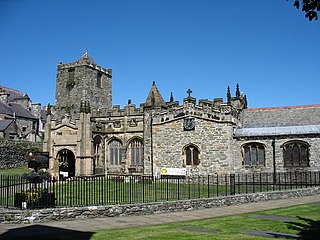
Saint Cybi or Saint Cuby was a 6th-century Cornish bishop, saint and, briefly, king, who worked largely in North Wales: his biography is recorded in two slightly variant medieval 'lives'.
Llangybi is a village and community in Monmouthshire, in southeast Wales, in the United Kingdom. It is located 3 miles (4.8 km) south of the town of Usk and 5 miles (8 km) north of Caerleon, in the valley of the River Usk.

St Hilary is a village in the Vale of Glamorgan, Wales. It is located just south of the A48, about a mile southeast of the market town of Cowbridge. The village has a population of about 260, in approximately 80 houses. Notable landmarks in the vicinity include The Bush Inn, the Church of St Hilary, the Old Beaupre Castle, New Beaupre, Coed Hills and St. Hilary mast.
Llan and its variants are a common placename element in Celtic languages. The name of the relevant saint or location follows the element: for example "Llanfair" is the parish or settlement around the church of St. Mair.

Llanarmon(English: Garmon's Church) is a small village and former civil parish in the old commote of Eifionydd and Cantref Dunoding in the Welsh county of Gwynedd. The parish was abolished in 1934 and incorporated into Llanystumdwy. The village lies 4 miles (6.4 km) north east of Pwllheli and is close to the village of Llangybi, a holy well and the mountain of Carn Pentrych. A well-preserved 15th-century manor house at Penarth-fawr is maintained by Cadw, and another ancient monument Plas Du(Welsh: Black Place) is a well-preserved, substantial sub-medieval gentry house. It also has important historical associations; it was known as the centre of the Roman Catholic faith in the region and was the home of Thomas Owen, High Sheriff of Caernarfonshire from 1569, who was imprisoned for sheltering missionary priests in the house in 1571.
"The village is pleasantly situated in a fertile plain, and the neighbour-hood partakes of the pleasing scenery which prevails in this part of the country. The living is a rectory not in charge, annexed to that of Llangybi, in the archdeaconry of Merioneth, and diocese of Bangor, and in the patronage of the Bishop of Bangor. The church, dedicated to Saint Garmon, is an ancient and spacious structure in good repair : some additional windows have lately been inserted, previously to which alteration the interior was very dark."
Samuel Lewis, Topographical Dictionary of Wales (1833)

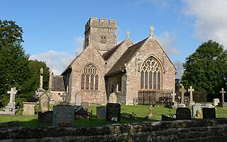
Llangybi is a village and parish in the south of Ceredigion, Wales. It is located on the A485 between Tregaron to the north and Lampeter to the south, a mile and a half north of the village of Betws Bledrws, which is in the wider community. Silian is another village located within the community.

St Mary's Church, Pentraeth is a small medieval parish church in the village of Pentraeth, in Anglesey, north Wales. The date of construction is unknown, but is probably from some time between the 12th to 14th centuries. A church dedicated to St Mary was recorded here in 1254, but there is a tradition that there was an older church dedicated to St Geraint, an early British saint. Some medieval stonework remains in three walls of the building. A chapel was added to the south side in the 16th or 17th century. The church was altered and refurbished during the 19th century, including an extensive rebuilding by Henry Kennedy, the architect for the Diocese of Bangor, in 1882. St Mary's is still used for worship by the Church in Wales, and is one of three churches in a combined parish. Its conservation is specifically included in the aims of a Chester-based charity that promotes health and the arts in Anglesey and the north-west of England.
St Caffo's Church, Llangaffo is a 19th-century church, in the south of Anglesey, north Wales, about 5 miles (8.0 km) from the county town, Llangefni. It was constructed in 1846 to replace the previous medieval church in the village of Llangaffo. The new building includes a number of monuments from the old church, and has a spire which is a prominent local landmark. The churchyard has part of a stone cross dating from the 9th or 10th century, and some gravestones from the 9th to 11th centuries. It is dedicated to St Caffo, a 6th-century martyr who was killed in the vicinity.
Caffo was a sixth-century Christian in Anglesey, north Wales, who is venerated as a saint and martyr. The son of a king from northern Britain who took shelter in Anglesey, Caffo was a companion of St Cybi, and is mentioned as carrying a red-hot coal in his clothes to Cybi without his clothes getting burnt. After leaving Cybi, Caffo was killed by shepherds in the south of Anglesey, possibly acting in retaliation for insults Caffo's brother had paid to the local ruler. The area where he died has a village, Llangaffo, named after him, as well as the parish church of St Caffo, Llangaffo.
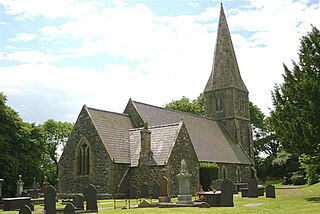
The Parish Church of St Hilary is a Grade II* listed Anglican church in the village of St Hilary in the Vale of Glamorgan, south Wales. It is one of 11 churches in the Parish of Cowbridge. It became a listed building on 22 February 1963.

St Enghenedl's Church, Llanynghenedl, is a former parish church in Anglesey, north Wales, dedicated to the son of a 6th-century King of Powys. According to the 19th-century antiquarian Angharad Llwyd, the first church in Llanynghenedl was erected in about 620. A new church was erected in 1862, replacing a building that the 19th-century clergyman and antiquarian Harry Longueville Jones noted as dating in part from the late 13th or early 14th century, based on the decorations on the south doorway. The church later fell into disuse as a result of the growth of the nearby village of Valley and the church there. In 1988, St Enghenedl's was dismantled and re-erected as an extension to St Mihangel's, Llanfihangel yn Nhowyn, so that St Mihangel's could serve as the church for RAF Valley. The former churchyard of St Enghenedl's is still visible but is now overgrown.(The churchyard is being cared for and no longer overgrown 2020 update)
In the United Kingdom, the term listed building refers to a building or other structure officially designated as being of special architectural, historical, or cultural significance; Grade I structures are those considered to be "buildings of exceptional interest". Listing was begun by a provision in the Town and Country Planning Act 1947. Once listed, strict limitations are imposed on the modifications allowed to a building's structure or fittings. In Wales, the authority for listing under the Planning Act 1990 rests with Cadw.

Eglwys y Bedd is all that remains of a 14th-century church in Anglesey, north Wales. It is set within the churchyard of St Cybi's, Holyhead, and may have been built on the site where Cybi lived and ministered. It is reputed to house the grave of Seregri, an Irish warrior who lived in the area in the 5th century.

Llandissilio is a village and parish in the community of Llandissilio West in east Pembrokeshire, Wales on the A478 road between Efailwen to the north and Clunderwen to the south. A largely ribbon development along the main road, the village is surrounded by farmland.
Saint Cyngar was a 5th-century Welsh Saint. He is the Patron Saint of Llangefni, Anglesey, in Wales, and a founding member of St. Cybi's Monastery at Holyhead, Anglesey.

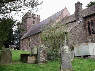
The Church of St Cybi, Llangybi, Monmouthshire is a parish church with its origins in the 13th or 14th century. Refurbished in the 15th century, the church was restored in 1909-10. The interior has a notable collection of medieval wall paintings, in particular a Christ of the Trades, dating from c.1460. The church, although an active parish church, is currently closed for a significant repair programme. It is a Grade II* listed building and the architectural writer John Newman, recording the church in the Buildings of Wales series, described it as "one of the most interesting in the Usk Valley."


