
Snowdonia is a mountainous region in northwestern Wales and a national park of 823 square miles (2,130 km2) in area. It was the first to be designated of the three national parks in Wales, in 1951.

The Second Severn Crossing, officially renamed the Prince of Wales Bridge since July 2018, is the M4 motorway bridge over the River Severn between England and Wales, inaugurated on 5 June 1996 by the Prince of Wales to supplement the traffic capacity of the Severn Bridge built in 1966. The bridge is operated by England's National Highways. It has a total length of 5,128 metres (16,824 ft).
The A487, officially the Fishguard to Bangor Trunk Road, is a trunk road in Wales that follows the coast from Haverfordwest, Pembrokeshire, in the south, to Bangor, Gwynedd, in the north.

Barmouth is a seaside town and community in the county of Gwynedd, northwestern Wales, lying on the estuary of the Afon Mawddach and Cardigan Bay. Located in the historic county of Merionethshire, the Welsh form of the name is derived from aber (estuary) and the river's name, "Mawddach". The English form of the name is a corruption of the earlier Welsh form Abermawdd. The community includes the tiny villages of Llanaber, Cutiau, and Caerdeon.

Dolgellau is a town and community in Gwynedd, north-west Wales, lying on the River Wnion, a tributary of the River Mawddach. It is traditionally the county town of the historic county of Merionethshire, which lost its administrative status when Gwynedd was created in 1974. Dolgellau is the main base for climbers of Cadair Idris. Although very small, it is the second largest settlement in Southern Gwynedd after Tywyn. The community includes Penmaenpool.

Fairbourne is a Welsh seaside village. It lies on the coast of Barmouth Bay in Arthog community, to the south of the estuary of the River Mawddach in Gwynedd, surrounded by the Snowdonia National Park. It is in an area listed by Gwynedd council for managed retreat due to rising sea levels.

The Afon Mawddach is a river in Gwynedd, Wales, which has its source in a wide area SH820300 north of Dduallt in Snowdonia. It is 28 miles (45 km) in length, and is much branched; many of the significant tributaries are of a similar size to the main river. The catchment area is bounded to the east by the Aran Fawddwy massif and to the west and north by the Harlech dome which forms a watershed just south of Llyn Trawsfynydd.

A trestle bridge is a bridge composed of a number of short spans supported by closely spaced frames. A trestle is a rigid frame used as a support, historically a tripod used to support a stool or a pair of isosceles triangles joined at their apices by a plank or beam such as the support structure for a trestle table. Each supporting frame is a bent. A trestle differs from a viaduct in that viaducts have towers that support much longer spans and typically have a higher elevation.

The Fairbourne Railway is a 12+1⁄4 in gauge miniature railway running for 2 miles (3.2 km) from the village of Fairbourne on the Mid-Wales coast, alongside the beach to the end of a peninsula at Barmouth Ferry railway station, where there is a connection with the Barmouth Ferry across the Mawddach estuary to the seaside resort of Barmouth.

Barmouth Bridge, or Barmouth Viaduct is a Grade II* listed single-track wooden railway viaduct across the estuary of the Afon Mawddach near Barmouth, Wales. It is 820 metres (900 yd) long and carries the Cambrian Line. It is the longest timber viaduct in Wales and one of the oldest in regular use in Britain.

The A494 is a trunk road in Wales and England. The route, which is officially known as the Dolgellau to South of Birkenhead Trunk Road, runs between the terminus of the M56 motorway between Mollington and Capenhurst and the A470 at Dolgellau, Gwynedd. Its northern sections remain among the busiest roads in Wales.

Morfa Mawddach railway station is an unstaffed station located on the outskirts of the village of Arthog in Gwynedd, Wales, on the Cambrian Coast line between Machynlleth and Pwllheli. Built by the Aberystwith and Welsh Coast Railway in 1865, it was formerly the junction station for the Ruabon to Barmouth Line. Since the closure of the Ruabon to Barmouth line in 1965, it remains open, as a minor station on the Cambrian Line.

Ffridd Gate was a station on the Corris Railway in Merioneth, Wales, UK. It was built at the level crossing over the B4404 road to Llanwrin, near the hamlet of Fridd. A small hamlet also grew up around the station and a nearby (pre-existent) toll-house. The hamlet and former station are near to the confluence of the Afon Dulas and the River Dyfi, around 2+1⁄4 miles (3.6 km) west of the village of Llanwrin and 1 mile (1.6 km) north of the town of Machynlleth.

Arthog is a village, post town and community in the Meirionnydd area in Gwynedd, north Wales including the villages of Fairbourne and Friog. It is located on the A493, approximately 8 miles (13 km) west of Dolgellau, and had a population of 1,010 in 2001, increasing slightly to 1,031 at the 2011 census.
The Ruabon–Barmouth line was a standard-gauge line owned by the Great Western Railway across the north of Wales which connected Ruabon, in the east, with Barmouth on the west coast.
The Aberystwith and Welsh Coast Railway was a standard gauge railway company, running a line along the west coast of Wales.

Penmaenpool railway station at Penmaenpool in Gwynedd, North Wales, was formerly a station on the Dolgelly [sic] branch of the Aberystwith and Welsh Coast Railway, part of the Ruabon to Barmouth Line. It closed to passengers on Monday 18 January 1965.
The Mawddach Trail is a cycle path route, part of Lôn Las Cymru, which runs for some 8 miles (13 km) from Dolgellau (52.7446°N 3.8866°W) to Morfa Mawddach railway station (52.7076°N 4.0315°W), by Barmouth bridge on the Cambrian coast. It is maintained by the Snowdonia National Park and is popular with walkers and cyclists alike. It passes some estuarine areas that are important for water birds, and the RSPB Information Centre at Penmaenpool makes use of the old signal box as an observation centre overlooking the estuary.
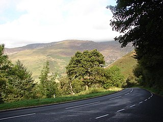
The A496 is a major coastal and mountainous road in southern Snowdonia.

Llanfachreth is a settlement approximately three miles north-east of Dolgellau, Gwynedd, in the community of Brithdir and Llanfachreth within the historic boundaries of Merionethshire, Wales.


