Ashby station (BART)

Last updated

Ashby
Ashby station platform from escalator, March 2018.JPG
Ashby station platform viewed from the mezzanine level
General information
Location3100 Adeline Street
Berkeley, California
Coordinates 37°51′11″N122°16′12″W / 37.853068°N 122.269957°W / 37.853068; -122.269957
Owned by San Francisco Bay Area Rapid Transit District, City of Berkeley
Line(s) BART R-Line
Platforms1 island platform
Tracks2
ConnectionsAiga bus trans.svg AC Transit: F, 12, 18, 800
Aiga bus trans.svg West Berkeley Shuttle
Construction
Structure typeUnderground
Parking715 spaces
Bicycle facilitiesracks, station, 24 shared lockers, 24 keyed reserved lockers
AccessibleYes
ArchitectMaher & Martens [1]
History
OpenedJanuary 29, 1973 [2]
Passengers
20242,008 (weekday average) [3]
Services
Preceding station Bart compact logo.svg Bay Area Rapid Transit Following station
MacArthur Orange Line Downtown Berkeley
toward Richmond
MacArthur
toward Millbrae
Red Line
Location
Ashby station (BART)

Ashby station is an underground Bay Area Rapid Transit (BART) station in Berkeley, California. The station is located beneath Adeline Street to the south of its intersection with Ashby Avenue. The station includes park-and-ride facilities with 715 automobile parking spaces in two separate parking lots. It is served by the Orange and Red lines.

Contents

Station layout

The station has a single island platform located below ground. The fare mezzanine is located at the same level as the west parking lot; stairs and an elevator provide access from Adeline Street overhead. The station is served several AC Transit routes that stop in different locations around its perimeter: [4]

The free West Berkeley Shuttle runs from the station to the West Berkeley area. [5]

History

Main entrance from the west parking lot Main entrance to Ashby station, March 2018.JPG
Main entrance from the west parking lot

The station site is approximately at the historic location of Berkeley Branch Railroad's Newbury station, which opened after 1876. [6] The BART Board approved the name "Ashby Place" in December 1965. [7] The three stations in Berkeley were originally planned to be elevated, but the City of Berkeley paid extra tax to have them built underground. The station design was controversial because it was not fully underground; the west side of the mezzanine is level with the parking lot. [8] [9] Eminent domain was used to take land for the parking lots, which contributed to the decline of the Black community in the area. [10] Service at Ashby station began on January 29, 1973, as part of the MacArthur to Richmond extension. [2]

Uniquely in the BART system, the City of Berkeley, rather than BART, controls the air rights on the parking lots. Between 2008 and 2010, a portion of the east parking lot was redeveloped as the Ed Roberts Campus, which houses several regional disability-related organizations. The east parking lot and station entrance were closed for construction on August 18, 2008. [11] The east parking lot reopened on April 19, 2010, and the Ed Roberts Campus and the new east entrance opened that November. [12] [13]

The west parking lot of the station hosts a popular flea market on weekends; a proposed residential transit-oriented development over the lot proved locally controversial. [14] The Berkeley City Council approved a memorandum of understanding with BART in December 2019 to begin planning for housing on the lot. [15] The council approved plans for housing at Ashby and North Berkeley in June 2022. [16] By July 2023, the Ashby development was stalled due to disagreements between BART and the city over a planned expansion of a BART electrical substation, which occupies part of the property. [17] BART presented modified plans to accommodate the substation in November 2023, with developer solicitation then planned for mid-2024. [18]

Related Research Articles

<span class="mw-page-title-main">Berkeley, California</span> City in California, United States

Berkeley is a city on the eastern shore of San Francisco Bay in northern Alameda County, California, United States. It is named after the 18th-century Anglo-Irish bishop and philosopher George Berkeley. It borders the cities of Oakland and Emeryville to the south and the city of Albany and the unincorporated community of Kensington to the north. Its eastern border with Contra Costa County generally follows the ridge of the Berkeley Hills. The 2020 census recorded a population of 124,321.

<span class="mw-page-title-main">Bay Area Rapid Transit</span> Rapid transit system serving the San Francisco Bay Area

Bay Area Rapid Transit (BART) is a rapid transit system serving the San Francisco Bay Area in California. BART serves 50 stations along six routes and 131 miles of track, including a 9-mile (14 km) spur line running to Antioch, which uses diesel multiple unit vehicles, and a 3-mile (4.8 km) automated guideway transit line serving San Francisco Bay Oakland International Airport. With an average of 160,400 weekday passengers as of the fourth quarter of 2023 and 48,119,400 annual passengers in 2023, BART is the seventh-busiest rapid transit system in the United States.

<span class="mw-page-title-main">Daly City station</span> Rapid transit station in California, US

Daly City station is an elevated Bay Area Rapid Transit (BART) station in Daly City, California, just south of the city limits of San Francisco. It is adjacent to Interstate 280 and California Route 1, which it serves as a park-and-ride station. The station is served by the Red, Yellow, Green, and Blue lines; it is the west terminal for the Green and Blue lines.

<span class="mw-page-title-main">West Oakland station</span> Rapid transit station in San Francisco Bay Area

West Oakland station is a Bay Area Rapid Transit (BART) station in the West Oakland neighborhood of Oakland, California. It has two elevated side platforms and is located near the eastern end of the Transbay Tube. All main BART lines except the Orange Line stop at the station. The Oakland Wye is located to the east of the station.

<span class="mw-page-title-main">Lake Merritt station</span> Rapid transit station in Oakland, California, US

Lake Merritt station is an underground Bay Area Rapid Transit (BART) station located east of Downtown Oakland near the eponymous Lake Merritt. The station is served by the Orange, Green, and Blue lines. It is the nearest BART station to Chinatown, Laney College, and Jack London Square station.

<span class="mw-page-title-main">19th Street Oakland station</span> Metro station in Oakland, California, US

19th Street Oakland station is an underground Bay Area Rapid Transit (BART) station located under Broadway between 17th Street and 20th Street in the Uptown District of Oakland, California. It is a timed transfer point between northbound trains to Richmond and to Antioch. The station has three underground levels, with tracks on the second and third levels. It is served by the Red Line, Orange Line, and Yellow Line, as well as by AC Transit buses on the surface at the Uptown Transit Center.

<span class="mw-page-title-main">Rockridge station</span> Metro station in Oakland, California, US

Rockridge station is a Bay Area Rapid Transit station located in the Rockridge district of Oakland, California. Located in the center median of the elevated State Route 24 west of the Caldecott Tunnel, the station has a single island platform serving two tracks. It is served by the Yellow Line.

<span class="mw-page-title-main">Orinda station</span> Rapid transit station in Orinda, California, US

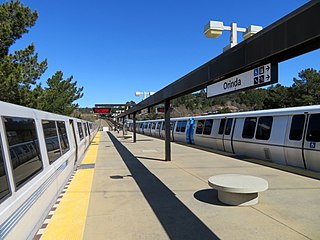
Orinda station is a Bay Area Rapid Transit station in Orinda, California. The station has an island platform in the center median of State Route 24. It is served by the Yellow Line. An abstract mural by Win Ng, partially covered by advertisements, is located in the fare lobby.

<span class="mw-page-title-main">Walnut Creek station</span> Rapid transit station in San Francisco Bay Area

Walnut Creek station is an elevated Bay Area Rapid Transit (BART) station in Walnut Creek, California, served by the Yellow Line. The station is located north of downtown Walnut Creek, adjacent to Interstate 680 and near the Ygnacio Valley Road and California Boulevard arterial roads.

<span class="mw-page-title-main">Pleasant Hill/Contra Costa Centre station</span> Rapid transit station in California, US

Pleasant Hill/Contra Costa Centre station is a Bay Area Rapid Transit (BART) station serving the Contra Costa Centre Transit Village in Contra Costa Centre, California, just north of Walnut Creek and just east of Pleasant Hill. It is served by the Yellow Line.

<span class="mw-page-title-main">Concord station (BART)</span> Rapid transit station in San Francisco Bay Area

Concord station is a Bay Area Rapid Transit (BART) station in Concord, California. The station is located between the downtown business district to the west and residential neighborhoods to the east. Concord station has a single elevated island platform and is served by the Yellow Line.

<span class="mw-page-title-main">Richmond station (California)</span> Railway station in Richmond, California, US

Richmond station is an Amtrak intercity rail and Bay Area Rapid Transit (BART) station located in downtown Richmond, California. Richmond is the north terminus of BART service on the Orange Line and Red Line; it is a stop for Amtrak's Capitol Corridor, San Joaquins, and California Zephyr routes. The accessible station has one island platform for the two BART tracks, with a second island platform serving two of the three tracks of the Union Pacific Railroad Martinez Subdivision for Amtrak trains. It is one of two transfer points between BART and Amtrak, along with Oakland Coliseum station.

<span class="mw-page-title-main">MacArthur station (BART)</span> Rapid transit station in San Francisco Bay Area

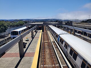
MacArthur station is a Bay Area Rapid Transit (BART) station in the Temescal District of Oakland, California. It is the largest station in the BART system, being the only one with four platform tracks. Service through MacArthur is timed for cross-platform transfers between the southbound lines that pass through the station. MacArthur station is located in the median of SR 24 just north of its interchange with I-580. The station is perpendicular to 40th Street and MacArthur Boulevard. The surrounding neighborhood is mostly low-density residential, making MacArthur station primarily a commuting hub.

<span class="mw-page-title-main">Downtown Berkeley station</span> Metro station in Berkeley, California, US

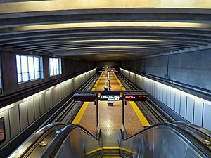
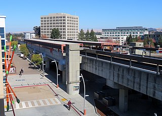
Downtown Berkeley station is an underground Bay Area Rapid Transit (BART) station in the Downtown Berkeley section of Berkeley, California. It is served by the Orange and Red lines.

<span class="mw-page-title-main">Union City station</span> Metro station in Union City, California, US

Union City station is a Bay Area Rapid Transit (BART) station in Union City, California. The station sits near Decoto Road east of Alvarado-Niles Road, directly behind the James Logan High School campus. The station is served by the Orange and Green lines. Local bus service is provided by Union City Transit and AC Transit.

<span class="mw-page-title-main">North Berkeley station</span> Metro station in Berkeley, California, US

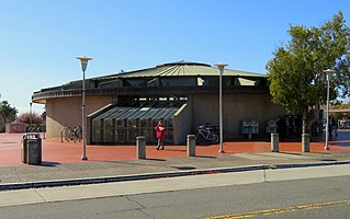
North Berkeley station is an underground Bay Area Rapid Transit (BART) station located in the North Berkeley neighborhood of Berkeley, California. It is bounded by Virginia Street, Sacramento Street, Delaware Street, and Acton Street in a residential area north of University Avenue. The main station entrance sits within a circular building at the center of a parking lot, while an elevator between the surface and the platform is located at the parking lot's Sacramento Street edge. The station is served by the Orange and Red lines.

<span class="mw-page-title-main">Hayward station (BART)</span> Metro station in Hayward, California, US

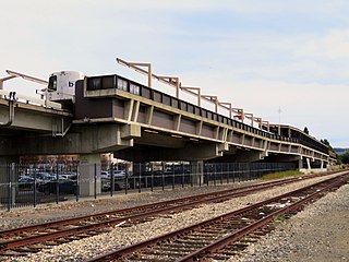
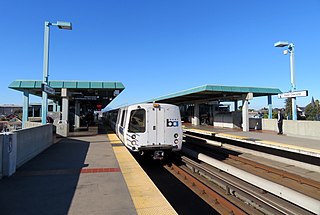
Hayward station is a Bay Area Rapid Transit (BART) station in Hayward, California, serving Downtown Hayward and the surrounding areas. It is served by the Orange and Green lines. The elevated station has two side platforms. A two-lane bus terminal is located on the northeast side of the station. A pedestrian tunnel under the Union Pacific Railroad Oakland Subdivision connects the fare lobby to a parking lot and a five-level parking garage.

<span class="mw-page-title-main">El Cerrito Plaza station</span> Rapid transit station in El Cerrito, California, US

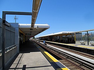
El Cerrito Plaza station is a Bay Area Rapid Transit (BART) station in El Cerrito, California, located adjacent to the El Cerrito Plaza shopping center. It primarily serves southern El Cerrito, northern Albany, and Kensington, along with nearby portions of Berkeley and Richmond. Nearly identical in form to El Cerrito del Norte station, El Cerrito Plaza station has two side platforms serving the line's two elevated tracks, with a fare lobby underneath. The Ohlone Greenway runs through the station area. The station is served by the Orange and Red lines.

<span class="mw-page-title-main">Oakland Coliseum station</span> Rail station in Oakland, California, US

The station complex of Amtrak's Oakland Coliseum station and Bay Area Rapid Transit (BART)'s Coliseum station is located in the East Oakland area of Oakland, California, United States. The two stations, located about 600 feet (180 m) apart, are connected to each other and to the Oakland Coliseum/Oakland Arena sports complex with an accessible pedestrian bridge. The BART station is served by the Orange, Green, and Blue lines; the Amtrak station is served by the Capitol Corridor service.

South Berkeley is a neighborhood in the city of Berkeley, California. It extends roughly from Dwight Way to the city’s border with Oakland, between Telegraph Avenue in the east and either Sacramento Street or San Pablo Avenue in the west. It lies at an elevation of 102 feet.

References

  1. Cerny, Susan Dinkelspiel (2007). An Architectural Guidebook to San Francisco and the Bay Area (1st ed.). Layton, UT: Gibbs Smith. pp. 501–502. ISBN   978-1-58685-432-4. OCLC   85623396.
  2. 1 2 "BART Chronology January 1947 – March 2009" (PDF). San Francisco Bay Area Rapid Transit District. March 2009. Archived from the original (PDF) on October 13, 2013.
  3. "Monthly Ridership Reports". San Francisco Bay Area Rapid Transit District. February 2024.
  4. "Transit Information: Ashby Station" (PDF). Metropolitan Transportation Commission. December 12, 2017.
  5. "West Berkeley Shuttle". Berkeley Gateway Transportation Management Association.
  6. "Downtown Berkeley Historic Resources Reconnaissance Survey" (PDF). City Of Berkeley. Retrieved April 17, 2019.
  7. "Names Approved for 38 Rapid Transit Stations Around Bay". Oakland Tribune. December 10, 1965. p. 10 via Newspapers.com.
  8. "Solution Hinted On Ashby Subway". Oakland Tribune. February 9, 1968. p. 21 via Newspapers.com. Open Access logo PLoS transparent.svg
  9. "Berkeley Station Agreement". Oakland Tribune. January 22, 1969. p. 9 via Newspapers.com.
  10. Dineen, J.K. (December 17, 2020). "Berkeley finally embracing housing in a bid to rebuild a historically Black neighborhood". San Francisco Chronicle. Retrieved August 8, 2023.
  11. "Ashby Station east entrance and lot to close for 18 months" (Press release). San Francisco Bay Area Rapid Transit District. August 1, 2008.
  12. "Ashby Station east parking lot to reopen April 19th" (Press release). San Francisco Bay Area Rapid Transit District. April 6, 2010.
  13. Taylor, Tracey (November 19, 2010). "Pioneering disability center opens its Berkeley campus". Berkeleyside.
  14. Orenstein, Natalie (March 27, 2017). "Possibilities for Adeline Corridor include BART underground, public park". Berkeleyside.
  15. Orenstein, Natalie (December 11, 2019). "Berkeley approves agreement with BART around housing at two stations". Berkeleyside.
  16. Hernández, Lauren; Ravani, Sarah (June 3, 2022). "Berkeley BART stations could see up to 3,600 units after council approves plans". San Francisco Chronicle. Retrieved August 8, 2023.
  17. Brown, Matthew (July 29, 2023). "Bay Area housing project on BART land is on hold due to dispute with transit agency". San Francisco Chronicle. Retrieved August 8, 2023.
  18. "Ashby BART Transit-Oriented Development: Traction Power Substation (TPSS) Update" (PDF). San Francisco Bay Area Rapid Transit District. November 8, 2023.

Commons-logo.svg Media related to Ashby station (BART) at Wikimedia Commons