Downtown Berkeley, Berkeley, California

Last updated
Downtown Berkeley
Berkeley-downtown-Bay-bridge-SF-in-back-from-Lab.jpg
Downtown Berkeley in the foreground, with San Francisco seen across the Bay
Location map Oakland.png
Red pog.svg
Downtown Berkeley
Location within Berkeley and the East Bay
Coordinates: 37°52′12″N122°16′05″W / 37.87°N 122.268°W / 37.87; -122.268
Country United States
State California
County Alameda
City Berkeley

Downtown Berkeley is the central business district of the city of Berkeley, California, United States, around the intersection of Shattuck Avenue and Center Street, and extending north to Hearst Avenue, south to Dwight Way, west to Martin Luther King Jr. Way, and east to Oxford Street. Downtown is the mass transit hub of Berkeley, with several AC Transit and UC Berkeley bus lines converging on the city's busiest BART station, as well as the location of Berkeley's civic center, high school, and Berkeley City College.

Contents

History

Addison Street, between Oxford Street and Shattuck Avenue, in 1994. The historic Studio Building is the second building on the right. Berkeley California1994.jpg
Addison Street, between Oxford Street and Shattuck Avenue, in 1994. The historic Studio Building is the second building on the right.

The area was formerly a settlement site of the Huichin/Chochen band of the Ohlone indigenous people. The site was probably associated with the proximity of Strawberry Creek which ran along what is today's Allston Way. During the days when the land was part of the vast Rancho San Antonio, a ford existed across Strawberry Creek beneath a clump of oak trees at approximately the intersection of Shattuck Avenue and Allston Way. The road or trail which crossed here connected the ranch houses of two of the Peralta brothers, Domingo and Vicente.

Following the Mexican–American War, four Americans laid claim to four equal strips of land in what is now downtown Berkeley, bounded on the north by what is today the alignment of Addison Street, and on the south, by Dwight Way. Among these claimants was Francis K. Shattuck. Shattuck's portion lay west of what is now Shattuck Avenue. He built a house here at the site of what is today the Hotel Shattuck Plaza. The county road going to Oakland along his property was informally called "Shattuck's road", but the planners of the College of California dubbed the street "Guyot" on their plat map. That name never caught on and the street name was upgraded to "Shattuck Avenue". In the 1890s, Strawberry Creek was culverted through the downtown section, the oak trees were removed, and Shattuck and University Avenues were improved. Nonetheless, the area developed slowly until about the time of the 1906 San Francisco earthquake, after which it developed rapidly.

The Central Pacific constructed its Berkeley Branch Railroad line connecting the area to the Oakland Pier and the transcontinental rail line in 1876, two years before the people living near the University of California and in Ocean View incorporated Berkeley. The end of the line at University Avenue was initially called the "Terminus" until the line was extended north, after which time it was called Berkeley Station. In the early years, downtown Berkeley was synonymous with "Berkeley Station", referring to the area around the railroad depot. The railroad served both passengers and freight at Berkeley Station. A telegraph office and Wells Fargo office were situated across the street from the depot.

The Key System opened up its electric train service to San Francisco from Downtown Berkeley in 1903. The Southern Pacific responded by electrifying and extending its lines in Berkeley in 1911 (East Bay Electric Lines) and moved its downtown freight operations just south of downtown to Ward Street and Shattuck. In 1941, however, SP ended its electric commuter train service. From then until April 1958, downtown Berkeley's commuter train service was solely in the hands of the Key System. Buses replaced the trains from 1958 to the present. In 1973, BART opened its own Berkeley station at Center Street and Shattuck, once again providing electric train service to San Francisco and elsewhere in the Bay Area.

For several years after the Key System's F train stopped running on Shattuck, its tracks (originally, the old SP tracks) remained in the pavement of Shattuck Avenue. Parking islands were created along the centerline of Shattuck overlapping the northbound tracks. In the early 1960s, a series of fountains were constructed which replaced some of these parking islands, extending from Center to Haste. The fountains quickly became the favorite targets of vandals who regularly put bubble bath in them. They were soon removed, just before Shattuck Avenue was torn up for the BART subway construction.

In early 2007 the Marine Recruiting Center for the northern Bay Area relocated from Alameda to downtown Berkeley in order to be closer to the University of California, Berkeley. [1] This move was met with protests from Code Pink, prompted the city council to pass a 6-3 resolution calling the Marines "uninvited and unwelcome intruders", and led to United States Senator Jim DeMint attempting to pass legislation that would strip Berkeley of its $2,392,000 in federal funding. [2] [3]

Commercial issues

University Avenue at night. Berkeleynight.jpg
University Avenue at night.

Berkeley's downtown section has been the principal commercial center of Berkeley since the railroad station was built. However, it has had to compete with the secondary commercial sections which emerged starting as early as the 19th century. Three of these in the past were West Berkeley (Ocean View), North Berkeley (Berryman's) and the Telegraph area immediately south of the University of California campus. Others which came a bit later were the Elmwood area along College near Ashby, San Pablo Avenue, South Berkeley (formerly the Lorin District) and Thousand Oaks along Solano Avenue.

Starting in the 1970s it also had to compete with the emergence of major shopping centers and malls outside of Berkeley, especially El Cerrito Plaza, Hilltop Mall, and Emeryville. These resulted in the loss of several formerly prominent downtown businesses, including two large department stores; Hink's, whose building was converted to a movie theater and several smaller stores, and J. C. Penney. Contributing factors which continue to date are high commercial rents, a shortage of street parking and convenient garages, and higher consumer prices than those offered elsewhere. The latter has been a problem since the earliest days as there has always been a tendency to view the University population as a captive consumer base. The city has created an official arts district along Addison Street and passed laws restricting business hours in other neighborhoods in an attempt to increase night time activity downtown. To address the parking situation, the city is planning to install a system of digital signs to direct drivers to available parking spaces downtown.

Today, Berkeley's downtown is highly eclectic, with numerous small businesses. Currently, the Berkeley City Council passed a new downtown area plan in an attempt to make the Downtown more sustainable and concentrate future development in the downtown area in conjunction with the announced plan of the University to build a hotel, conference center, and museum along Center Street. In 2009 local petition gatherers gained enough signatures to obstruct implementation of the plan, angering many residents of Berkeley, including the coalition of the Sierra Club, the Greenbelt Alliance, Berkeley Food & Housing Project and TransForm. The opponents argue that the new development calls for buildings that are too tall and have housing that is too expensive. Supporters of the downtown plan counter that the plan requires 20% affordable housing units and a denser downtown reduces carbon emissions.

In recent years, Shattuck Avenue has seen the opening of a number of new high-profile restaurants.

Government

Downtown Berkeley is a part of Berkeley's District 4 and is represented by Kate Harrison. It is considered a left-leaning neighborhood in civic politics.

Related Research Articles

<span class="mw-page-title-main">Berkeley, California</span> City in California, United States

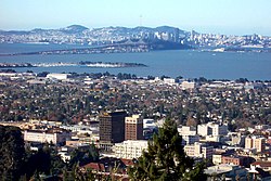
Berkeley is a city on the eastern shore of San Francisco Bay in northern Alameda County, California, United States. It is named after the 18th-century Anglo-Irish bishop and philosopher George Berkeley. It borders the cities of Oakland and Emeryville to the south and the city of Albany and the unincorporated community of Kensington to the north. Its eastern border with Contra Costa County generally follows the ridge of the Berkeley Hills. The 2020 census recorded a population of 124,321.

<span class="mw-page-title-main">Balboa Park station</span> Transit station in San Francisco, California, US

Balboa Park station is a Bay Area Rapid Transit (BART) station and Muni Metro complex in the Mission Terrace neighborhood of San Francisco, California, located near the eponymous Balboa Park. It is an intermodal hub served by four BART routes, three Muni Metro lines, and a number of Muni bus routes. The station complex also includes two rail yards, Cameron Beach Yard and Green Light Rail Center, where Muni maintains Muni Metro trains and heritage streetcars. BART uses a below-grade island platform on the west side of the complex; Muni Metro routes use several smaller side platforms located on surface-level rail loops around the yards.

<span class="mw-page-title-main">Richmond station (California)</span> Railway station in Richmond, California, US

Richmond station is an Amtrak intercity rail and Bay Area Rapid Transit (BART) station located in downtown Richmond, California. Richmond is the north terminus of BART service on the Orange Line and Red Line; it is a stop for Amtrak's Capitol Corridor, San Joaquins, and California Zephyr routes. The accessible station has one island platform for the two BART tracks, with a second island platform serving two of the three tracks of the Union Pacific Railroad Martinez Subdivision for Amtrak trains. It is one of two transfer points between BART and Amtrak, along with Oakland Coliseum station.

<span class="mw-page-title-main">Ashby station (BART)</span> Rapid transit station in San Francisco Bay Area

Ashby station is an underground Bay Area Rapid Transit (BART) station in Berkeley, California. The station is located beneath Adeline Street to the south of its intersection with Ashby Avenue. The station includes park-and-ride facilities with 715 automobile parking spaces in two separate parking lots.

<span class="mw-page-title-main">Downtown Berkeley station</span> Rapid transit station in San Francisco Bay Area

Downtown Berkeley station is an underground Bay Area Rapid Transit (BART) station in Berkeley, California. The station serves Downtown Berkeley and the surrounding areas.

<span class="mw-page-title-main">North Berkeley station</span> Rapid transit station in San Francisco Bay Area

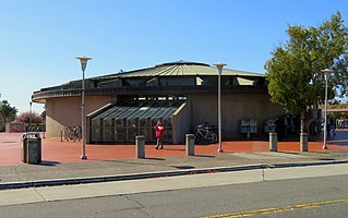
North Berkeley station is an underground Bay Area Rapid Transit (BART) station located on Sacramento Street in Berkeley, California. The station serves the North Berkeley neighborhood and the surrounding areas. It is bounded by Virginia Street, Sacramento Street, Delaware Street, and Acton Street in a residential area north of University Avenue. The main station entrance sits within a circular building at the center of a parking lot, while an elevator between the surface and the platform is located at the parking lot's Sacramento Street edge.

Solano Avenue in Berkeley and Albany, California is a two-mile (3.2 km) long east-west street. Solano Avenue is one of the larger shopping districts in the Berkeley area. Businesses along Solano Avenue cover a wide range, including grocery stores, coffee shops, drugstores, bookstores, antique dealers, apparel outlets, ethnic restaurants and a movie theater.

<span class="mw-page-title-main">Emeryville station</span> Amtrak station in Emeryville, California, United States

Emeryville station is an Amtrak station in Emeryville, California, United States. The station is served by the California Zephyr, Capitol Corridor, Coast Starlight, and San Joaquins. The station is the primary connection point for Amtrak Thruway buses serving San Francisco.

<span class="mw-page-title-main">Temescal, Oakland, California</span> Neighborhood of Oakland in Alameda, California, United States

Temescal is one of the oldest neighborhoods in Oakland, California, located in North Oakland, and centered on Telegraph Avenue. The neighborhood derives its name from Temescal Creek, a significant watercourse in the city.

<span class="mw-page-title-main">Strawberry Creek</span> River in California, United States

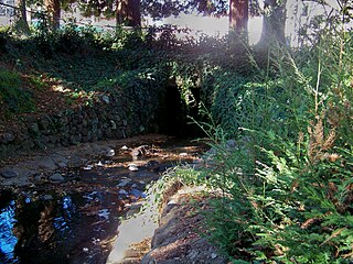
Strawberry Creek is the principal watercourse running through the city of Berkeley, California. Two forks rise in the Berkeley Hills of the California Coast Ranges, and form a confluence at the campus of the University of California, Berkeley. The creek then flows westward across the city to discharge into San Francisco Bay.

<span class="mw-page-title-main">East Bay Electric Lines</span> Former railway lines in the San Francisco Bay Area

The East Bay Electric Lines were a unit of the Southern Pacific Railroad that operated electric interurban-type trains in the East Bay region of the San Francisco Bay Area. Beginning in 1862, the SP and its predecessors operated local steam-drawn ferry-train passenger service in the East Bay on an expanding system of lines, but in 1902 the Key System started a competing system of electric lines and ferries. The SP then drew up plans to expand and electrify its system of lines and this new service began in 1911. The trains served the cities of Berkeley, Albany, Emeryville, Oakland, Alameda, and San Leandro transporting commuters to and from the large Oakland Pier and SP Alameda Pier. A fleet of ferry boats ran between these piers and the docks of the Ferry Building on the San Francisco Embarcadero.

<span class="mw-page-title-main">Ohlone Greenway</span>

The Ohlone Greenway is a 4.5-mile (7.2 km) pedestrian and bicycle path in the East Bay region of the San Francisco Bay Area.

The Berkeley Branch Railroad was a 3.84-mile (6.18 km) long branch line of the Central Pacific Railroad (CPRR) from a junction in what later became Emeryville called "Shellmound" to what soon became downtown Berkeley, adjacent to the new University of California campus. The line opened on August 16, 1876. The initial terminal point was at Shattuck and University Avenues in Berkeley. In 1878, the line was extended north along Shattuck to Vine with the original terminus then becoming Berkeley Station. The line connected at Shellmound with trains headed to the Oakland Pier and ferries to San Francisco. Beginning on January 22, 1882, Berkeley Branch trains proceeded directly to the pier.

<span class="mw-page-title-main">Oakland Coliseum station</span> Rail station in Oakland, California, US

The station complex of Amtrak's Oakland Coliseum station and Bay Area Rapid Transit (BART)'s Coliseum station is located in the East Oakland area of Oakland, California, United States. The two stations, located about 600 feet (180 m) apart, are connected to each other and to the Oakland Coliseum/Oakland Arena sports complex with an accessible pedestrian bridge.

<span class="mw-page-title-main">Berkeley station (Southern Pacific Railroad)</span>

Berkeley Station was the name of the principal railroad station in Berkeley, California from 1878 to 1911. It was located in what is now downtown Berkeley, on Shattuck Avenue between University Avenue and Center Street. The tract is today occupied by Shattuck Square and Berkeley Square. The name continued in use after 1911 although the station was no longer the main rail depot for Berkeley.

<span class="mw-page-title-main">Downtown Richmond, Richmond, California</span>

Downtown Richmond is the old center of Richmond, California. The area is roughly bordered by 6th street to the west, 23rd Street to the east, Barrett Avenue to the north, and Macdonald Avenue to the south. The area once featured major department stores and other chains such as J.C. Penney, Macy's, S. H. Kress & Co., and Sears before Hilltop Mall was built in the 1970s.The area is currently undergoing a revitalization effort by the city, which has included the Richmond Shopping Center anchored by a supermarket. The Richmond Transit Village—coined Metro Walk by the developers, the Olson Company—has also been built, along with remodeling of the Richmond BART and Amtrak station and a bus transit center served by AC Transit and Golden Gate Transit. A Kaiser Permanente hospital and a Social Security Administration processing center provide for a majority of the jobs in the area.

<span class="mw-page-title-main">Downtown Oakland</span> Central business district of Oakland, California

Downtown Oakland is the central business district of Oakland, California, United States. It is located roughly bounded by both the Oakland Estuary and Interstate 880 on the southwest, Interstate 980 on the northwest, Grand Avenue on the northeast, and Lake Merritt on the east.

<span class="mw-page-title-main">Pittsburg Center station</span> Rapid transit station in San Francisco Bay Area

Pittsburg Center station is a Bay Area Rapid Transit station on the Yellow Line. It is located at the Railroad Avenue overpass of Highway 4 in Pittsburg, California and serves the downtown area of about one mile (1.6 km) away via connecting buses provided by Tri Delta Transit. There is no reserved parking available at this station.

<span class="mw-page-title-main">Shattuck Avenue</span>

Shattuck Avenue is a major city street running north–south through Berkeley, California, and Oakland, California. At its southern end, the street branches from Telegraph Avenue in Oakland's Temescal district, then ends at Indian Rock Park in the Berkeley Hills to the north. Shattuck Avenue is the main street of Berkeley, forming the spine of that city's downtown, and the site of the Gourmet Ghetto in North Berkeley. The street was named for Francis Kittredge Shattuck, an early landowner and booster who later served as Mayor of Oakland. Shattuck was largely responsible for the original construction of the road as well as for a railroad built along its route.

References

  1. Kwong, Jessica (2007-10-17). "Protests Follow Recruiting Center to Berkeley". The Daily Californian . Independent Berkeley Students Publishing Company, Inc. Archived from the original on 2008-02-16. Retrieved 2008-02-05.
  2. Shalev, Asaf (2008-01-30). "City Council Passes Motions Criticizing Marines Office". The Daily Californian . Independent Berkeley Students Publishing Company, Inc. Archived from the original on 2008-02-03. Retrieved 2008-02-05.
  3. Shin, Jane; Kamal, Ameea (2008-02-07). "Senators Put Forward Act to Withhold Funds: Legislation in Response to Recruiting Center Opposition Would Remove Millions in Funds from Local Projects". The Daily Californian . Independent Berkeley Students Publishing Company, Inc. Archived from the original on 2008-02-10. Retrieved 2008-02-07.

37°52′12″N122°16′05″W / 37.87°N 122.268°W / 37.87; -122.268