Downtown Berkeley station

Last updated
Downtown Berkeley
Richmond-bound train at Downtown Berkeley station, June 2019.JPG
Richmond-bound train at Downtown Berkeley in June 2019
General information
Location2160 Shattuck Avenue
Berkeley, California
Coordinates 37°52′11″N122°16′06″W / 37.869799°N 122.268197°W / 37.869799; -122.268197
Line(s) BART R-Line
Platforms1 island platform
Tracks2
ConnectionsAiga bus trans.svg AC Transit: 6, 7, 18, 51B, 52, 65, 67, 79, 88, 800, 851, F, FS
Aiga bus trans.svg Bear Transit: C, H, P, R, RFS
Construction
Structure typeUnderground
Bicycle facilities Station
AccessibleYes
ArchitectMaher & Martens
History
OpenedJanuary 29, 1973
Rebuilt2016–2018
Previous namesBerkeley (1973–1995)
Passengers
20245,397 (weekday average) [1]
Services
Preceding station Bart compact logo.svg Bay Area Rapid Transit Following station
Ashby Orange Line North Berkeley
toward Richmond
Ashby
toward Millbrae
Red Line
Location
Downtown Berkeley station

Downtown Berkeley station is an underground Bay Area Rapid Transit (BART) station in the Downtown Berkeley section of Berkeley, California. It is served by the Orange and Red lines.

Contents

History

Southern Pacific

The Central Pacific Railroad opened its Berkeley Branch Railroad to the intersection of Shattuck and University Avenues on August 16, 1876. [2] Early civic leader Francis K. Shattuck donated land for the railroad and its depot, and subsidized the initial construction. [3] Berkeley was the terminus of the line until 1878, when it was extended northwest along Shattuck. The Central Pacific was leased by the Southern Pacific Railroad (SP) in 1885, then transferred to its Northern Railway subsidiary in 1888. [2] The first Berkeley station was a small wooden building at the northwest corner of Center Street and Shattuck; it was replaced in the 1890s by a slightly larger by still modest station. [3] [4]

On October 26, 1903, the Key System began electric commuter rail operation from Berkeley to the San Francisco ferries – a direct threat to the SP's steam-hauled trains – on a line that paralleled the SP tracks on Shattuck. [5] Around that time, Cal president Benjamin Ide Wheeler and other prominent Berkeley academics lobbied SP president E. H. Harriman for an improved train station to complement John Galen Howard's emerging architectural style for the nearby University of California, Berkeley. [3] Finally, the devastating 1906 earthquake and subsequent rebuilding "served as a powerful incentive to expedite the project". [3]

Surveying work began in June 1906; that September, SP management announced their intentions to convert their suburban lines to a frequent electric service to compete with the Key System. [3] The new station, an elegant red brick structure with buff terracotta trim, red tile roof, and a colonnade, opened on April 9, 1908. It was officially designed by SP architect Daniel J. Patterson in a similar style to Émile Bénard's original plans for the university, though the high quality of its design and circumstantial evidence led some historians to believe it was actually designed by Howard. [3] The SP lines were fully electrified in 1911. [5]

BART

Entrance to the Berkeley BART station (bottom right) as seen shortly after the station opened in 1973 Berkeley BART Station 1973 Postcard.jpg
Entrance to the Berkeley BART station (bottom right) as seen shortly after the station opened in 1973

The BART Board approved the name "Berkeley" in December 1965. [6] The station opened on January 29, 1973, as part of the extension from MacArthur to Richmond. [7] The station was designed by Maher & Martens of San Francisco in collaboration with Parsons Brinckerhoff, Tudor Construction, and Bechtel. [8]

In 1995, BART changed the name of the station from "Berkeley" to "Downtown Berkeley" in an effort to minimize confusion between this station and North Berkeley.[ citation needed ]

Removal of rotunda

New main entrance to the station. New Downtown Berkeley BART entrance.jpg
New main entrance to the station.

A station and plaza renovation project began construction on August 29, 2016 [9] and opened to the public on October 19, 2018. [10] The new plaza includes new lighting, landscaping, drainage, paving, and bus shelters in the overground plaza of the station. The old main rotunda entrance has been removed and was replaced by a glass entrance structure similar to those in Downtown Oakland. [11] The $11.2 million project is funded primarily by BART, with additional funding from the City of Berkeley, Metropolitan Transportation Commission, and Alameda County. A further project to renovate the underground station interior is in the planning stages. [12]

The entrances on the southern end of the station were closed from April 13, 2020, to June 12, 2021, due to low ridership during the COVID-19 pandemic. [13] Bathrooms at underground BART stations were closed after the September 11 attacks due to security concerns. The bathroom at Downtown Berkeley station reopened on June 30, 2023, after a renovation, with an attendant on duty during all operating hours. [14]

Station layout

Like most underground BART stations, Downtown Berkeley has two levels: a mezzanine containing the faregates and an island platform with two tracks. Access to the station is provided by five street-level entrances on Shattuck Avenue, with two at Addison Street and Allston Way each and one at the southwest corner of Shattuck Avenue and Center Street. [15] The escalators at the latter were topped by an 24-sided rotunda featuring artwork of the UC Botanical Garden.

Related Research Articles

<span class="mw-page-title-main">Bay Area Rapid Transit</span> Rapid transit system serving the San Francisco Bay Area

Bay Area Rapid Transit (BART) is a rapid transit system serving the San Francisco Bay Area in California. BART serves 50 stations along six routes and 131 miles of track, including a 9-mile (14 km) spur line running to Antioch, which uses diesel multiple unit vehicles, and a 3-mile (4.8 km) automated guideway transit line serving Oakland International Airport. With an average of 160,400 weekday passengers as of the fourth quarter of 2023 and 48,119,400 annual passengers in 2023, BART is the seventh-busiest rapid transit system in the United States.

<span class="mw-page-title-main">Embarcadero station</span> Subway station in San Francisco, California, US

Embarcadero station is a combined BART and Muni Metro rapid transit subway station in the Market Street subway in downtown San Francisco. Located under Market Street between Drumm Street and Beale Street near The Embarcadero, it serves the Financial District neighborhood and surrounding areas. The three-level station has a large fare mezzanine level, with separate platform levels for Muni Metro and BART below. Embarcadero station opened in May 1976 – almost two years after service began through the Transbay Tube – as an infill station.

<span class="mw-page-title-main">Montgomery Street station</span> Rapid transit station in San Francisco, California, US

Montgomery Street station is a combined BART and Muni Metro rapid transit subway station in the Market Street subway in downtown San Francisco. Located under Market Street between Montgomery Street and Sansome Street, it serves the Financial District neighborhood and surrounding areas. The three-level station has a large fare mezzanine level, with separate platform levels for Muni Metro and BART below. Montgomery Street and Embarcadero station to the north are typically the two busiest stations in the BART system.

<span class="mw-page-title-main">Powell Street station</span> Rapid transit station in San Francisco, California, US

Powell Street station is a combined BART and Muni Metro rapid transit station in the Market Street subway in downtown San Francisco. Located under Market Street between 4th Street and 5th Street, it serves the Financial District neighborhood and surrounding areas. The three-level station has a large fare mezzanine level, with separate platform levels for Muni Metro and BART below. The station is served by the BART Red, Yellow, Green, and Blue lines, and the Muni Metro J Church, K Ingleside, L Taraval, M Ocean View, N Judah, and S Shuttle lines.

<span class="mw-page-title-main">Civic Center/UN Plaza station</span> Rapid transit station in San Francisco, California, US

Civic Center/UN Plaza station is a combined BART and Muni Metro rapid transit station in the Market Street subway in downtown San Francisco. Located under Market Street between 7th Street and 8th Street, it is named for the Civic Center neighborhood and the adjacent United Nations Plaza. The three-level station has a large fare mezzanine level, with separate platform levels for Muni Metro and BART below.

<span class="mw-page-title-main">16th Street Mission station</span> Metro station in San Francisco, California, US

16th Street Mission station is a Bay Area Rapid Transit station located under Mission Street at 16th Street in the Mission District of San Francisco, California. Service at the station began, along with other stations between Montgomery Street Station and the Daly City station, on November 5, 1973. The station is served by the Red, Yellow, Green, and Blue lines.

<span class="mw-page-title-main">24th Street Mission station</span> Rapid transit station in San Francisco, California, US

24th Street Mission station is a Bay Area Rapid Transit (BART) station located under Mission Street at 24th Street in the Mission District of San Francisco, California. The station is served by the Red, Yellow, Green, and Blue lines.

<span class="mw-page-title-main">Millbrae station</span> Train station in Millbrae, California, U.S.

Millbrae station is an intermodal transit station serving Bay Area Rapid Transit (BART) and Caltrain, located in Millbrae, California. The station is the terminal station for BART on the San Francisco Peninsula, served by two lines: The Red Line before 9 pm and the Yellow Line during the early morning and evening. It is served by all Caltrain services. The station is also served by SamTrans bus service, Commute.org and Caltrain shuttle buses, and other shuttles.

<span class="mw-page-title-main">12th Street Oakland City Center station</span> Rapid transit station in Oakland, California, US

12th Street/Oakland City Center station is an underground Bay Area Rapid Transit (BART) station located under Broadway between 12th Street and 14th Street in Downtown Oakland, adjacent to the Oakland City Center. The station has three underground levels, with tracks on the second and third levels. It is served by the Red Line, Orange Line, and Yellow Line, as well as by AC Transit buses on the surface.

<span class="mw-page-title-main">19th Street Oakland station</span> Metro station in Oakland, California, US

19th Street Oakland station is an underground Bay Area Rapid Transit (BART) station located under Broadway between 17th Street and 20th Street in the Uptown District of Oakland, California. It is a timed transfer point between northbound trains to Richmond and to Antioch. The station has three underground levels, with tracks on the second and third levels. It is served by the Red Line, Orange Line, and Yellow Line, as well as by AC Transit buses on the surface at the Uptown Transit Center.

<span class="mw-page-title-main">Walnut Creek station</span> Rapid transit station in San Francisco Bay Area

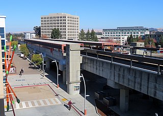
Walnut Creek station is an elevated Bay Area Rapid Transit (BART) station in Walnut Creek, California, served by the Yellow Line. The station is located north of downtown Walnut Creek, adjacent to Interstate 680 and near the Ygnacio Valley Road and California Boulevard arterial roads.

<span class="mw-page-title-main">Richmond station (California)</span> Railway station in Richmond, California, US

Richmond station is an Amtrak intercity rail and Bay Area Rapid Transit (BART) station located in downtown Richmond, California. Richmond is the north terminus of BART service on the Orange Line and Red Line; it is a stop for Amtrak's Capitol Corridor, San Joaquins, and California Zephyr routes. The accessible station has one island platform for the two BART tracks, with a second island platform serving two of the three tracks of the Union Pacific Railroad Martinez Subdivision for Amtrak trains. It is one of two transfer points between BART and Amtrak, along with Oakland Coliseum station.

<span class="mw-page-title-main">Ashby station (BART)</span> Metro station in Berkeley, California, US

Ashby station is an underground Bay Area Rapid Transit (BART) station in Berkeley, California. The station is located beneath Adeline Street to the south of its intersection with Ashby Avenue. The station includes park-and-ride facilities with 715 automobile parking spaces in two separate parking lots. It is served by the Orange and Red lines.

<span class="mw-page-title-main">North Berkeley station</span> Metro station in Berkeley, California, US

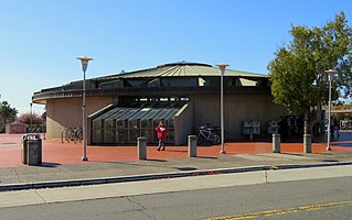
North Berkeley station is an underground Bay Area Rapid Transit (BART) station located in the North Berkeley neighborhood of Berkeley, California. It is bounded by Virginia Street, Sacramento Street, Delaware Street, and Acton Street in a residential area north of University Avenue. The main station entrance sits within a circular building at the center of a parking lot, while an elevator between the surface and the platform is located at the parking lot's Sacramento Street edge. The station is served by the Orange and Red lines.

<span class="mw-page-title-main">Hayward station (BART)</span> Metro station in Hayward, California, US

Hayward station is a Bay Area Rapid Transit (BART) station in Hayward, California, serving Downtown Hayward and the surrounding areas. It is served by the Orange and Green lines. The elevated station has two side platforms. A two-lane bus terminal is located on the northeast side of the station. A pedestrian tunnel under the Union Pacific Railroad Oakland Subdivision connects the fare lobby to a parking lot and a five-level parking garage.

<span class="mw-page-title-main">Downtown Berkeley, Berkeley, California</span> Neighborhood of Berkeley in Alameda, California, United States

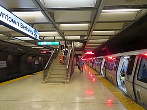
Downtown Berkeley is the central business district of the city of Berkeley, California, United States, around the intersection of Shattuck Avenue and Center Street, and extending north to Hearst Avenue, south to Dwight Way, west to Martin Luther King Jr. Way, and east to Oxford Street. Downtown is the mass transit hub of Berkeley, with several AC Transit and UC Berkeley bus lines converging on the city's busiest BART station, as well as the location of Berkeley's civic center, high school, and Berkeley City College.

<span class="mw-page-title-main">Downtown Oakland</span> Central business district of Oakland, California

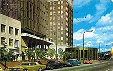
Downtown Oakland is the central business district of Oakland, California, United States. It is located roughly bounded by both the Oakland Estuary and Interstate 880 on the southwest, Interstate 980 on the northwest, Grand Avenue on the northeast, and Lake Merritt on the east.

<span class="mw-page-title-main">Warm Springs/South Fremont station</span> Rapid transit station in San Francisco Bay Area

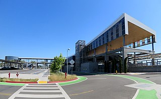
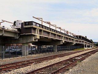
Warm Springs/South Fremont station is a Bay Area Rapid Transit (BART) station located in the Warm Springs district of Fremont, California. The station is served by the Orange and Green lines. It was the southern terminus of both lines from its opening on March 25, 2017 until June 13, 2020, when Milpitas and Berryessa/North San José stations opened as part of the Silicon Valley BART extension.

<span class="mw-page-title-main">Tempo (bus rapid transit)</span> Bus service in Oakland and San Leandro, California

Tempo is a bus rapid transit (BRT) service in Oakland and San Leandro in California. It is operated by AC Transit as Line 1T. The route has dedicated lanes and center-boarding stations along much of the corridor, prepaid fares, signal preemption, and all-door boarding.

References

  1. "Monthly Ridership Reports". San Francisco Bay Area Rapid Transit District. February 2024.
  2. 1 2 Robertson, Donald B. (1986). Encyclopedia of Western Railroad History: California. Caxton Press. p. 77. ISBN   978-0-87004-385-7 via Google Books.
  3. 1 2 3 4 5 6 Thompson, Daniella (August 18, 2008). "Berkeley Square: from transport hub to urban core". Berkeley Architectural History Association.
  4. "Berkeley, Alameda Co., Cal". Charles A. Bailey. 1890 via Online Archive of California.
  5. 1 2 "A pictorial history of public transportation in the East Bay, commemorating the achievements of the last century – from the beginning of the first train and ferry service in 1863 to the vast transportation network of today operated by the Alameda-Contra Costa Transit District" (PDF). Transit Times. Vol. 6, no. 5. Alameda-Contra Costa Transit District. September 1963. pp. 17, 26.
  6. "Names Approved for 38 Rapid Transit Stations Around Bay". Oakland Tribune. December 10, 1965. p. 10 via Newspapers.com.
  7. "BART Chronology January 1947 – March 2009" (PDF). San Francisco Bay Area Rapid Transit District. March 2009. Archived from the original (PDF) on October 13, 2013.
  8. Cerny, Susan (2007). An Architectural Guidebook to San Francisco and the Bay Area. Gibbs Smith. p. 502. ISBN   978-1-58685-432-4.
  9. Pao, Roann (30 August 2016). "Construction begins on Downtown Berkeley BART station plaza". The Daily Californian. Retrieved 8 February 2017.
  10. Dinkelspiel, Frances (October 19, 2018). "New Downtown Berkeley BART Plaza opens to fanfare". Berkeleyside. Retrieved October 23, 2018.
  11. Bay Area Rapid Transit District. "Downtown Berkeley BART Plaza and Transit Area Improvement Project" . Retrieved 8 February 2017.
  12. Bay Area Rapid Transit District. "Downtown Berkeley Station Modernization" . Retrieved 8 February 2017.
  13. "BART opens all entrances/exits that were previously closed due to pandemic" (Press release). San Francisco Bay Area Rapid Transit District. June 12, 2021.
  14. "BART reopens restrooms at Embarcadero and Downtown Berkeley stations" (Press release). San Francisco Bay Area Rapid Transit District. June 30, 2023.
  15. "Downtown Berkeley Station map". San Francisco Bay Area Rapid Transit District. Archived from the original on October 8, 2014. Retrieved July 29, 2019.