
Livermore is a city in Alameda County, California. With a 2020 population of 87,955, Livermore is the most populous city in the Tri-Valley, giving its name to the Livermore Valley. It is located on the eastern edge of California's San Francisco Bay Area, making it the easternmost city in the area. The current mayor is John Marchand.

The Tri-Valley area is grouping of three valleys in the East Bay region of California's Bay Area. The three valleys are Amador Valley, San Ramon Valley, and Livermore Valley. The Tri-Valley encompasses the cities of Dublin, Livermore, Pleasanton and San Ramon, the town of Danville and the CDPs of Alamo, Blackhawk and Diablo. The area is known for its Mediterranean climate, wineries, and nature. It is primarily suburban in character. The United States Census Bureau defines an urban area centered in the cities of Livermore, Pleasanton, and Dublin with a 2020 population of 240,381, ranked 167th in the United States in terms of population. The total population of the area is estimated to be 361,000. It offers more affordable living accommodations than the cities of San Francisco and San Jose.

The Altamont Corridor Express is a commuter rail service in California, connecting Stockton and San Jose during peak hours only. ACE is named for the Altamont Pass, through which it runs. Service is managed by the San Joaquin Regional Rail Commission, and operations are contracted to Herzog Transit Services. The 86-mile (138 km) route includes ten stops, with travel time about 2 hours and 12 minutes end-to-end. In 2023, the line had a ridership of 576,300, or about 2,500 per weekday as of the fourth quarter of 2023. ACE uses Bombardier BiLevel Coaches, MPI F40PH-3C locomotives, and Siemens Charger locomotives.

Wheels is a public bus service in the Tri-Valley region (southeast Alameda County) of the San Francisco Bay Area in California, United States. It is operated by the Livermore Amador Valley Transit Authority (LAVTA). Wheels operates local and limited-stop service in Dublin, Pleasanton, and Livermore, with limited service into Contra Costa County along Interstate 680. The LAVTA was formed in 1985; service began in Dublin and Pleasanton in 1986. In 1987, it took over the 1978-opened Rideo service in Livermore. In 2023, the system had a ridership of 1,289,600, or about 5,100 per weekday as of the fourth quarter of 2023.

Richmond station is an Amtrak intercity rail and Bay Area Rapid Transit (BART) station located in downtown Richmond, California. Richmond is the north terminus of BART service on the Orange Line and Red Line; it is a stop for Amtrak's Capitol Corridor, San Joaquins, and California Zephyr routes. The accessible station has one island platform for the two BART tracks, with a second island platform serving two of the three tracks of the Union Pacific Railroad Martinez Subdivision for Amtrak trains. It is one of two transfer points between BART and Amtrak, along with Oakland Coliseum station.

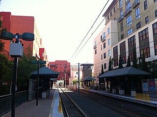
Dublin/Pleasanton station is a Bay Area Rapid Transit (BART) station on the border of Dublin and Pleasanton in California. It is the eastern terminus of the Blue Line. It is also a major bus terminal served by six providers.

El Cerrito del Norte station is a Bay Area Rapid Transit (BART) station located on Cutting Boulevard in El Cerrito, California. The station is served by the Orange and Red lines. Located near San Pablo Avenue and Interstate 80, it serves as a regional transit hub for local AC Transit bus services, and for commuter feeder services from Solano, Napa, and Marin Counties in the North Bay plus western Contra Costa County. Opened in 1973, the station was renovated in 2017–2021 to add additional elevators, stairs, and lobby space.

Emeryville station is an Amtrak station in Emeryville, California, United States. The station is served by the California Zephyr, Capitol Corridor, Coast Starlight, and San Joaquins. The station is the primary connection point for Amtrak Thruway buses serving San Francisco.
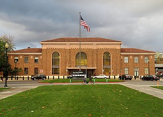
San Jose Diridon station is the central passenger rail depot for San Jose, California. It also serves as a major intermodal transit center for Santa Clara County and Silicon Valley. The station is named after former Santa Clara County Supervisor Rod Diridon Sr.

People in the San Francisco Bay Area rely on a complex multimodal transportation infrastructure consisting of roads, bridges, highways, rail, tunnels, airports, seaports, and bike and pedestrian paths. The development, maintenance, and operation of these different modes of transportation are overseen by various agencies, including the California Department of Transportation (Caltrans), the Association of Bay Area Governments, San Francisco Municipal Transportation Agency, and the Metropolitan Transportation Commission. These and other organizations collectively manage several interstate highways and state routes, eight passenger rail networks, eight trans-bay bridges, transbay ferry service, local and transbay bus service, three international airports, and an extensive network of roads, tunnels, and bike paths.

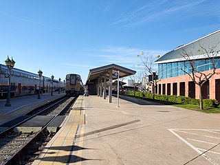
Santa Clara Transit Center is a railway station in downtown Santa Clara, California. It is served by Caltrain, Amtrak Capitol Corridor, and Altamont Corridor Express (ACE) trains. It is the planned terminus for the Silicon Valley BART extension into Santa Clara County on the future Green and Orange Lines. The former station building, constructed in 1863 by the San Francisco and San Jose Railroad, is used by the Edward Peterman Museum of Railroad History.
Bakersfield station is an intermodal facility in Bakersfield, California. It is the southern terminus of Amtrak California's San Joaquins route, with Amtrak Thruway buses continuing to Amtrak stations and bus stops throughout Southern California and Nevada. The station opened with a celebration on July 4, 2000. It contains an 8,300-square-foot (770 m2) train station with two platforms and three tracks, as well as a 17-bay bus station.
Del Mar station is an at-grade light rail station on the A Line of the Los Angeles Metro Rail system. It is located between Arroyo Parkway and Raymond Avenue at Del Mar Boulevard, after which the station is named, in Pasadena, California. The station is located on the site of the historic Pasadena Santa Fe Depot and the station building, built in 1935, still stands on the property.
The Highway 17 Express is an Amtrak Thruway route provided by a consortium of entities that provides regional service between San Jose and Santa Cruz County in the South Bay of the San Francisco Bay Area. The service is so called because it travels on California State Route 17. It is operated by the Santa Cruz Metropolitan Transit District.

Vasco Road station is an ACE station on Vasco Road in eastern Livermore, California. The station mainly serves the workers of Lawrence Livermore National Laboratory, Sandia National Laboratory and the surrounding industrial and office parks in eastern Livermore in addition to commuters from Livermore headed to job centers in the Silicon Valley to the southwest.

Robert J. Cabral Station, is a railway station in Stockton, California. In 2003, the station building was named in honor of the late Robert J. Cabral, a San Joaquin County supervisor instrumental in the creation of the Altamont Corridor Express (ACE), originally Altamont Commuter Express.
Throughout the history of Bay Area Rapid Transit, there have been plans to extend service to other areas.
Tracer is the public bus system for the city of Tracy, California. Unique among transit agencies, since 2002 the service operates as free public transport every April and December.

Valley Link is a proposed 26-mile-long (42 km) commuter rail service in Northern California, which seeks to connect the rapid transit Bay Area Rapid Transit (BART) system in the San Francisco Bay Area with the northern San Joaquin Valley via the Tri-Valley region. Since 1997, BART's Blue Line's eastern terminus is at Dublin/Pleasanton station on the border of Dublin and Pleasanton. Valley Link seeks to extend rail service east from here into the northern San Joaquin Valley over Altamont Pass and to help alleviate traffic congestion and reducing greenhouse gas emissions on Interstate 580 (I-580). The project resulted from various failed proposals to extend the Blue Line east to Livermore.
Isabel station is a proposed commuter rail train station in Livermore, California. It is expected to open in 2027 as a stop for Valley Link. The station's parking lot and bus bays are located on the north side of East Airway Boulevard while the platforms and rails are located in the median strip of Interstate 580 just east of Isabel Avenue.

