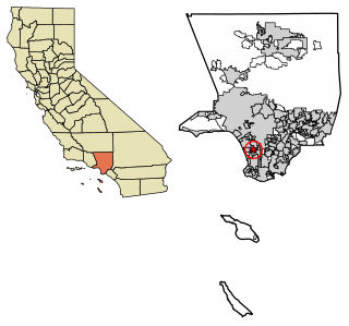
Alondra Park, also known as El Camino Village, is a census designated place (CDP) in Los Angeles County, California, United States. It is the unincorporated area north of Alondra Community Regional Park and El Camino College. It is east of Lawndale, south of Hawthorne, west of Gardena, and north of Torrance. Manhattan Beach Boulevard and Crenshaw Boulevard are the two major cross streets in the area. The population was 8,569 at the 2020 census, down from 8,592 at the 2010 census. There is an official Alondra Park Post Office of the U.S. Postal Service in nearby Gardena, California. Urbanized cement-lined Dominguez Creek bisects a portion of Alondra Park.

Gardena is a city located in the South Bay region of Los Angeles County, California, United States. The population was 58,829 at the 2010 census, up from 57,746 at the 2000 census. Until 2014, the US census cited the City of Gardena as the place with the highest percentage of Japanese Americans in California. Gardena's Japanese American population contributes to the South Bay region of Los Angeles being home to the largest concentration of Japanese companies within the mainland United States.
Hawthorne is a city in the Los Angeles metropolitan area, located in southwestern Los Angeles County, California. It is part of a seventeen-city region commonly called the South Bay. As of the 2020 US census, Hawthorne had a population of 88,083.

Pico-Union is a neighborhood in Central Los Angeles, California. The name "Pico-Union" refers to the neighborhood that surrounds the intersection of Pico Boulevard and Union Avenue. Located immediately west of Downtown Los Angeles, it is home to over 40,000 residents.
West Los Angeles is an area within the city of Los Angeles, California, United States. The residential and commercial neighborhood is divided by the Interstate 405 freeway, and each side is sometimes treated as a distinct neighborhood, mapped differently by different sources. Each lies within the larger Westside region of Los Angeles County.

East Hollywood is a densely populated neighborhood of 78,000+ residents that's part of the Hollywood area of the central region of Los Angeles, California. It is notable for being the site of Los Angeles City College, Barnsdall Park, and a hospital district. There are seven public and five private schools, a Los Angeles Public Library branch, and three hospitals. Almost two-thirds of the people living there were born outside the United States, and 90% were renters. In 2000, the neighborhood had high percentages of never-married people and single parents.

The Harbor Gateway is a 5.14-square-mile residential and industrial area (13.3 km2) in the Los Angeles Harbor Region, in the southern part of the city. The neighborhood is narrow and long, running along a north-south axis. Its unusual shape has given it the alternative name of "the Shoestring Strip". The northern limit of the neighborhood is Imperial Highway, a city street just north of I-105.
Lake Balboa is a neighborhood in the San Fernando Valley region of Los Angeles, California. The area was previously part of Van Nuys.

University Park is a 1.17 square miles (3.0 km2) neighborhood in the South Los Angeles region of Los Angeles, California. It is the home of the University of Southern California (USC), Mount St. Mary's College and Hebrew Union College. Additionally, the neighborhood is the home of the historic Shrine Auditorium.

Chesterfield Square is a 0.63-square-mile neighborhood in Los Angeles, California, located within the South Los Angeles region. It contains its namesake park, along with the Van Ness Recreation Center.

Manchester Square is a neighborhood in Los Angeles, California, within the South Los Angeles region.

West Park Terrace is a neighborhood in South Los Angeles. The 2009 Mapping L.A. project of the Los Angeles Times gave the same area a different name: Grammercy Park.

Central-Alameda is a 2.18 square miles (5.65 km2) square mile neighborhood within the South Los Angeles region of Los Angeles, California.
Green Meadows is a neighborhood in South Los Angeles, California, with a population of more than thirty thousand people. Green Meadows is within the South Los Angeles Community Plan area and is the home of Locke College Preparatory Academy.

Harvard Park is a 0.64-square-mile neighborhood in the South Los Angeles region of Los Angeles, California. It is centered on a municipal park by that name.
Vermont-Slauson is a 1.44-square-mile neighborhood within the South Los Angeles region of Los Angeles, California.

Adams-Normandie is a Historic Preservation Overlay Zone (HPOZ) in South Los Angeles, California, United States.

Exposition Park is a neighborhood in the south region of Los Angeles, California. It is home to Exposition Park, which includes the Los Angeles Memorial Coliseum, BMO Stadium, Exposition Rose Garden and three museums: the California African American Museum, the California Science Center and the Natural History Museum of Los Angeles County. It is also home to a Science Center Academy.

Vermont Vista is a neighborhood in Los Angeles, California, within the South Los Angeles area.

Hollywood Hills West is a neighborhood within Central Los Angeles, California.


