The South Bay is a region of the Los Angeles metropolitan area, located in the southwest corner of Los Angeles County. The name stems from its geographic location stretching along the southern shore of Santa Monica Bay. The South Bay contains sixteen cities plus portions of the City of Los Angeles and unincorporated portions of the county. The area is bounded by the Pacific Ocean on the south and west and generally by the City of Los Angeles on the north and east.

Long Beach is a city in Los Angeles County, California, United States. It is the 43rd-most populous city in the United States, with a population of 451,307 as of 2022. A charter city, Long Beach is the seventh-most populous city in California, the second most populous city in Los Angeles County, and the largest city in California that is not a county seat city.
Carson is a city in the South Bay and the Harbor regions of Los Angeles County, California, located 13 miles (21 km) south of downtown Los Angeles and approximately 14 miles (23 km) away from Los Angeles International Airport. It was Incorporated on February 20, 1968. The city is locally known for its plurality of Filipino-Americans and immigrants. As of the 2020 United States Census, the city had a population of 95,558.

San Pedro is a neighborhood located within the South Bay and Harbor region of the City of Los Angeles, California, United States. Formerly a separate city, it consolidated with Los Angeles in 1909. The Port of Los Angeles, a major international seaport, is partially located within San Pedro. The district has grown from being dominated by the fishing industry, to a working-class community within the city of Los Angeles, to an increasingly dense and diverse community.

Wilmington is a neighborhood in the South Bay and Harbor region of Los Angeles, California, covering 9.14 square miles (23.7 km2).
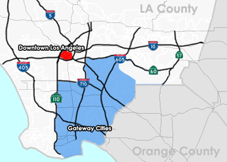
The Gateway Cities Region, or Southeast Los Angeles County, is an urbanized region located in southeastern Los Angeles County, California, between the City of Los Angeles proper, Orange County, and the Pacific Ocean. The cluster of cities has been termed "Gateway Cities" in that they serve as a "gateway" between the LA and Orange counties, with the city of Cerritos equidistant from Downtown L.A., Long Beach, and Santa Ana in Orange County. As such, the area is central to the Los Angeles-Long Beach-Anaheim, CA Metropolitan Statistical Area (MSA), and has a population of approximately 2,000,000 residents.

Area codes 310 and 424 are telephone area codes in the North American Numbering Plan (NANP) for the U.S. state of California. The numbering plan area includes the West Los Angeles and South Bay areas of Los Angeles County, a small portion of Ventura County, and Santa Catalina Island, which is located 26 miles (42 km) south.

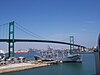
San Pedro Bay is an inlet on the Pacific Ocean coast of southern California, United States. It is the site of the Port of Los Angeles and the Port of Long Beach, which together form the fifth-busiest port facility in the world and the busiest in the Americas. The Los Angeles community of San Pedro borders a small portion of the western side of the bay. The city of Long Beach borders the port on the eastern side of the bay. The northern part of the bay, which is the largest part of the port, is bordered by the Los Angeles neighborhood of Wilmington.
Central Los Angeles is the historical urban region of the City of Los Angeles, California.

The Harbor Gateway, historically and sometimes informally known as the Shoestring due to its shape, is a 5.14-square-mile residential and industrial area (13.3 km2) in the South Bay and Los Angeles Harbor Region, in the southern part of the City of Los Angeles. The neighborhood is narrow and long, running along a north-south axis. The northern boundary of the neighborhood is Imperial Highway, a city street just north of I-105, while the southern boundary is marked by a southern segment of Sepulveda Boulevard.

State Route 47 is a state highway in the U.S. state of California, connecting Terminal Island to the mainland in the Los Angeles area. From its south end at I-110 in San Pedro, it heads east across the Vincent Thomas Bridge to the island and the end of state maintenance. The state highway begins again at the junction with I-710 on Terminal Island, crossing the Schuyler Heim Bridge north to the mainland and the second terminus, where SR 103 begins. Signage continues along a locally maintained route, mainly Alameda Street, to the Gardena Freeway in Compton, and an unconstructed alignment follows the same corridor to the Santa Monica Freeway (I-10) near downtown Los Angeles.
The San Pedro Pastoral Region is a pastoral region of the Archdiocese of Los Angeles in the Roman Catholic Church. It covers Long Beach and southern Los Angeles County, with its headquarters in Lakewood. The current regional auxiliary bishop is Bishop Marc V. Trudeau. The region has 68 parishes, 10 high schools, many elementary schools, 6 hospitals, and no Spanish missions.

California's 44th congressional district is a congressional district in the U.S. state of California. The district is centered in South Los Angeles and the Los Angeles Harbor Region. It is currently represented by Democrat Nanette Barragán. The 44th district was created as a result of the redistricting cycle after the 1980 census.

Don Manuel Domínguez e Ybáñez (1803–1882) was a Californio ranchero, politician, and a signer of the California Constitution in 1849. He served as two terms as Alcalde of Los Angeles (mayor). He was one of the largest landowners in Southern California, having inherited Rancho San Pedro in 1825, one of the largest ranchos in California. He was one of the founders of the cities of Carson and Compton and of the fishing village of San Pedro. Today, California State University, Dominguez Hills and the communities of Rancho Dominguez, East Rancho Dominguez, and West Rancho Dominguez bear his family's name.
Rancho San Pedro was one of the first California land grants and the first to win a patent from the United States. The Spanish Crown granted the 75,000 acres (300 km2) of land to soldier Juan José Domínguez in 1784, with his descendants validating their legal claim with the Mexican government at 48,000 acres (190 km2) in 1828, and later maintaining their legal claim through a United States patent validating 43,119 acres (174.50 km2) in 1858. The original Spanish land grant included what today consists of the Pacific coast cities of Los Angeles harbor, San Pedro, the Palos Verdes peninsula, Torrance, Redondo Beach, Hermosa Beach, and Manhattan Beach, and east to the Los Angeles River, including the cities of Lomita, Gardena, Harbor City, Wilmington, Carson, Compton, and western portions of Long Beach and Paramount.
Rancho Dominguez is an unincorporated community in Los Angeles County, California, United States. Rancho Dominguez is located between the cities of Compton, Long Beach and Carson.
Dominguez Channel is a 15.7-mile-long (25.3 km) river in southern Los Angeles County, California, in the center of the Dominguez Watershed of 133 square miles (340 km2).

Harbor City is a highly diverse neighborhood in the South Bay and Harbor region of Los Angeles, California, with a population upward of 36,000 people. Originally part of the Rancho San Pedro Spanish land grant, the 2.58-square-mile (6.7 km2) Harbor City was brought into Los Angeles as a preliminary step in the larger city's consolidation with the port cities of Wilmington and San Pedro.

San Pedro via Dominguez was a 25.39-mile (40.86 km) interurban transport route, part of the Pacific Electric system in Greater Los Angeles. Its termini were the Pacific Electric Building in Downtown Los Angeles and San Pedro in the south.

Rancho Dominguez Preparatory School (RDPS) is a public middle and high school in Long Beach, California in the Los Angeles metropolitan area, California, United States. It is a part of the Los Angeles Unified School District. It was previously named South Region High School #4.