Baldwin, New York | |
---|---|
Coordinates: 40°40′12.8″N73°36′45″W / 40.670222°N 73.61250°W | |
Country | United States |
State | New York |
County | Nassau County, New York |
Town | Hempstead |
Elevation | 23 ft (7.0104 m) |
Population (2010) | |
• Total | 24,033 |
Time zone | UTC-5 (Eastern (EST)) |
• Summer (DST) | UTC-4 (EDT) |
ZIP Code | 11510 |
Area code | 516 |
GNIS feature ID | 942888 |
Website | baldwinchamber |
Baldwin is a hamlet located in the Town of Hempstead in Nassau County, on Long Island, New York, United States. It had a population of 33,919 in 2020. [1]
The original inhabitants of this area between Parsonage Creek near Oceanside and Milburn Creek near Freeport were Native Americans known as the Meroke, or Merrick, a band of Lenape people who were indigenous to most of the South Shore of Long Island. They spoke an Algonquian language and lived in two villages along Milburn Creek. [2]
In 1643, English colonists began to call this area Hick's Neck, after one of two of Hempstead's early settlers, John Spragg from England and John Hicks from Flushing, New York. They extended the Hempstead village south to the salt meadows. The grist mill built by John Pine in 1686 on Milburn Creek attracted more English settlers. [3] They engaged in fishing, farming, marshing, raising longwood, and breeding and raising sheep. Between the American Revolutionary War and the War of 1812, Hick's Neck continued to grow, becoming a prosperous agricultural area. [4]
The first churches were built in the area in 1810 and 1872, and the first school was built in 1813. [5]
Sometime around the early 19th century Hick's Neck began to be called Milburn. The first documented use of the name Milburn was in 1839. [4] In 1855, the village was officially founded as Baldwinsville, named in honor of Thomas Baldwin (1795–1872), a sixth-generation member of the Baldwin family of Hempstead and the leading merchant of Milburn at the time. Baldwin owned a general store named T. Baldwin and Sons. He also had a hotel at what would now be considered the northwest corner of Merrick Road and Grand Avenue. [6]
In 1867, the South Side Railroad began operating at a station in Baldwinsville. In 1870, one of Thomas Baldwin's sons, Francis Baldwin, became a member of the New York State Assembly representing Queens County's 2nd District; he later served as the Queens County treasurer. [5] During this time, Baldwinsville was part of Queens County. A year later, the name of the village was changed from Baldwinsville to Baldwins by the U.S. Postal Service so as to not confuse it with the village of Baldwinsville in upstate New York. By 1892, by an act of local government, the village was officially named Baldwin. [6]
Shortly after Hempstead separated from Queens County in 1899, people began to move to "Beautiful Baldwin", as it was called by Charles Luerssen, a village realtor. The village had boating (sailboats), bathing, and fishing. By 1939, ten years after the opening of Sunrise Highway, Baldwin became the largest unincorporated village in New York State—a title that was lost to Levittown by 1960. [6]
In the 1990 US Census, the area south of Atlantic Avenue was designated as Baldwin Harbor, a hamlet and census-designated place. Baldwin Harbor remains a part of Baldwin's ZIP code, school district, and library system.
In May 1910, a breakthrough in American aviation history was made in Baldwin. The first all-American monoplane was designed, built, and successfully flown at this location by brothers Arthur and Albert Heinrich. The project was developed at the site now occupied by the Plaza Elementary School on Seaman Avenue and Rockville Drive. In the plane's initial and subsequent models, its unique designs featured controls that were combined into one stick, which allowed the pilot to fly the plane using one hand. [7]
The community is located in the southwestern section of Nassau County, on Long Island's South Shore of Long Island. [8]
According to the United States Census Bureau, the hamlet has a total area of 3.0 square miles (7.8 km2), of which 0.34% is water.
The climate is borderline between a hot summer humid continental climate (Dfa) and a humid subtropical climate (Cfa). Average monthly temperatures in the village center range from 31.9 °F in January to 74.8 °F in July. [9] The local hardiness zone is 7b.
There were 1,200 people in the community of Baldwin in 1882, [10] 1,500 in 1890, 5,000 in 1920, [10] 12,000 in 1930, 15,000 in 1940, and 31,630 in 1980. [11]
As of the census [12] [13] of 2010, there were 23,455 people, 7,868 households, and 6,081 families residing in the village. The population density was 7,954.4 inhabitants per square mile (3,071.2/km2). There were 7,999 housing units at an average density of 2,712.8 per square mile (1,047.4/km2). The racial makeup of the CDP was 39.8% Non-Hispanic White, 34.6% African American, 20.2% Hispanic or Latino, 4.2% Asian, 0.2% Native American, 0.02% Native Hawaiian and Other Pacific Islander, 8.2% from other races, and 3.9% from two or more races.
There were 7,868 households, out of which 38.3% had children under the age of 18 living with them, 61.0% were married couples living together, 12.7% had a female householder with no husband present, and 22.7% were non-families. Of all households, 18.5% were made up of individuals, and 9.3% had someone living alone who was 65 years of age or older. The average household size was 2.98 and the average family size was 3.40.
In the community, the population was spread out, with 26.1% under the age of 18, 7.2% from 18 to 24, 30.5% from 25 to 44, 24.1% from 45 to 64, and 12.0% who were 65 years of age or older. The median age was 37 years. For every 100 females, there were 89.9 males. For every 100 females aged 18 and over, there were 85.2 males.
The median income for a household in the community was $72,456, and the median income for a family was $79,400. Males had a median income of $52,069 versus $41,496 for females. The per capita income for the CDP was $29,114. About 1.1% of families and 1.4% of the population were below the poverty line, including 3.5% of those under the age of 18, and 2.1% of those aged 65 or over.
As of the census [12] of 2000, there were 23,455 people, 7,868 households, and 6,081 families residing in the village. The population density was 7,954.4 inhabitants per square mile (3,071.2/km2). There were 7,999 housing units at an average density of 2,712.8 per square mile (1,047.4/km2). The racial makeup of the CDP was 67.3% White, 17.9% African American, 10.6% Hispanic or Latino, 1.1% Asian, 0.8% Native American, 0.3% Pacific Islander, 4.60% from other races, and 3.03% from two or more races.
There were 7,868 households, out of which 38.3% had children under the age of 18 living with them, 61.0% were married couples living together, 12.7% had a female householder with no husband present, and 22.7% were non-families. Of all households, 18.5% were made up of individuals, and 9.3% had someone living alone who was 65 years of age or older. The average household size was 2.98 and the average family size was 3.40.
In the community, the population was spread out, with 26.1% under the age of 18, 7.2% from 18 to 24, 30.5% from 25 to 44, 24.1% from 45 to 64, and 12.0% who were 65 years of age or older. The median age was 37 years. For every 100 females, there were 89.9 males. For every 100 females age 18 and over, there were 85.2 males.
The median income for a household in the community was $71,456, and the median income for a family was $78,400. Males had a median income of $51,069 versus $40,496 for females. The per capita income for the CDP was $28,114. About 3.3% of families and 5.4% of the population were below the poverty line, including 5.5% of those under the age of 18, and 7.1% of those aged 65 or over.
Baldwin is home to many public parks, including Coes Neck Park, Lofts Pond Park, Milburn Pond Park, and Silver Lake Park (which is also in Oceanside). [8]
Baldwin is served primarily by the Baldwin Union Free School District. However, small parts are also served by the Oceanside UFSD, Rockville Centre UFSD, Roosevelt UFSD, and Uniondale UFSD. Additionally, a portion of the Freeport UFSD crosses into the hamlet, but the area only includes Milburn Pond Park. [8] [14] Children who reside within Baldwin and attend public schools go to school in one of these districts depending on where in the hamlet they live. [8] [14] The names of the schools are Lenox Elementary, Plaza Elementary, Meadow Elementary, Brookside Elementary, Steele Elementary, Baldwin Middle School, and Baldwin High School.
Baldwin was also home to one Catholic school: St. Christopher's. The school closed on July 24, 2021. [15]
Baldwin is located within the boundaries of the Baldwin, Freeport, Oceanside, Rockville Centre, Roosevelt, and Uniondale Library Districts. [8] The borders of each district within the hamlet roughly correspond with those of each school district. [8]
The Baldwin Long Island Railroad station is located in the hamlet. [8] [16] It is on the LIRR's Babylon Branch. [16]
Major roads which pass through the hamlet include:
National Grid USA provides natural gas to homes and businesses that are hooked up to natural gas lines in Baldwin. [17] [18]
PSEG Long Island provides power to all homes and businesses within Baldwin. [17] [19]
The soldiers who were posthumously awarded the Medal of Honor:
First Lieutenant Bernard J. Ray deliberately gave his life to spare his men of Company F, 8th Infantry, 4th Infantry Division on November 17, 1944, in the Hurtgen Forest.
Specialist Five John J. Kedenburg (BHS '64) was serving with a long-range reconnaissance team of South Vietnamese irregular troops while a member of the U.S. Army 5th Special Forces Group (Airborne). When his group came under attack and was encircled by a battalion-size North Vietnamese Army force, Kedenberg conducted a rear-guard action which allowed his group to break out of their encirclement and move to a landing zone. While in the landing zone, Kedenberg directed the defense of the L-Z and ultimately gave up the last chance of evacuation to one of his Vietnamese comrades.
Baldwin Harbor is a hamlet and former census-designated place (CDP) in the Town of Hempstead, in Nassau County, on Long Island, in New York, United States. It was created concomitant with the 1990 United States Census from the southernmost portions of the neighboring hamlet of Baldwin. As of the 2010 census, it had a population of 8,102.
Barnum Island is a hamlet and census-designated place (CDP) in Nassau County, New York, United States. The population was 2,590 at the 2020 census. It occupies the eastern portion of an island situated between Long Island and Long Beach. That island, previously known in its entirety as Hog Island, consists entirely of the communities of Barnum Island and Island Park.
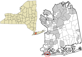
Bay Park is a hamlet and census-designated place (CDP) in the Town of Hempstead in Nassau County, on the South Shore of Long Island, in New York, United States. The population was 2,212 at the 2010 census.
East Atlantic Beach is a hamlet and census-designated place (CDP) in Nassau County, New York, United States. The population was 2,049 at the 2010 census. The unincorporated hamlet is governed by the Town of Hempstead, one of three towns in Nassau County.
Great Neck Gardens is a hamlet and census-designated place (CDP) located on the Great Neck Peninsula in Nassau County, on the North Shore of Long Island, New York, United States. The population was 1,186 at the 2010 census. As an unincorporated hamlet, it is governed by the Town of North Hempstead.
Greenvale is a hamlet and census-designated place (CDP) in the towns of North Hempstead and Oyster Bay in Nassau County, on the North Shore of Long Island, in New York, United States. It is considered part of the Greater Roslyn area, which is anchored by the Incorporated Village of Roslyn. The population was 1,069 at the time of the 2020 census.
Harbor Hills is a hamlet and census-designated place (CDP) located on the Great Neck Peninsula within the Town of North Hempstead in Nassau County, on the North Shore of Long Island, in New York, United States. The population was 575 at the 2010 census.
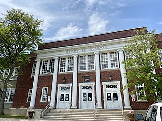
Herricks is a hamlet and census-designated place (CDP) in Nassau County, on Long Island, in New York, United States. The population was 4,398 at the 2020 census.
Hewlett is a hamlet and census-designated place (CDP) in the Town of Hempstead in Nassau County, on Long Island, in New York, United States. The population was 6,819 at the 2010 census.
Malverne Park Oaks is a hamlet and census-designated place (CDP) in the Town of Hempstead in Nassau County, on Long Island, in New York, United States. The population was 538 at the 2020 census.
Manhasset Hills is a hamlet and census-designated place (CDP) in the Town of North Hempstead in Nassau County, on Long Island, in New York, United States. The population was 3,592 at the 2010 census. Neighboring communities include Herricks, North Hills, North New Hyde Park, and Lake Success.
North Valley Stream is a hamlet and census-designated place (CDP) in the Town of Hempstead in Nassau County, on Long Island, in New York, United States. The population was 18,197 at the time of the 2020 census.
Oceanside is a hamlet and census-designated place (CDP) located in the southern part of the town of Hempstead, Nassau County, New York, United States. The population was 32,109 at the 2010 census.
Port Washington is a hamlet and census-designated place (CDP) on the Cow Neck Peninsula in the Town of North Hempstead, in Nassau County, on the North Shore of Long Island, in New York. The hamlet is the anchor community of the Greater Port Washington area. The population was 16,753 at the 2020 census.
Rockville Centre, commonly abbreviated as RVC, is an incorporated village located in the Town of Hempstead in Nassau County, on the South Shore of Long Island, in New York, United States. The population was 26,016 at the 2020 census.
Roosevelt is a hamlet and census-designated place (CDP) in the Town of Hempstead in Nassau County, on the South Shore of Long Island, in New York, United States. The population was 18,066 at the 2020 census.
Saddle Rock Estates is a hamlet and census-designated place (CDP) located on the Great Neck Peninsula within the Town of North Hempstead in Nassau County, on the North Shore of Long Island, in New York, United States. The population was 466 at the 2010 census.
South Valley Stream is an unincorporated hamlet and census-designated place (CDP) in the Town of Hempstead in Nassau County, on Long Island, in New York, United States. The population was 6,386 as of the 2020 census.
University Gardens is a hamlet and a census-designated place (CDP) in Nassau County, on the North Shore of Long Island, in New York, United States. It is located within the Town of North Hempstead and is part of the Greater Great Neck area. The population was 4,358 at the time of the 2020 census.
East Patchogue is a census-designated place (CDP) in the Town of Brookhaven in Suffolk County, on the South Shore of Long Island, in New York, United States. The population was 22,469 at the 2010 census. The CDP is a proximate representation of the East Patchogue hamlet used for statistical purposes of the Census Bureau.