Related Research Articles
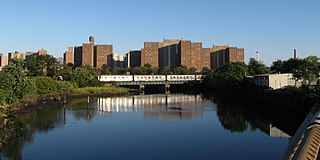
Coney Island Creek is a 1.8-mile-long (2.9 km) tidal inlet in Brooklyn, New York City. It used to be a 3-mile-long (4.8 km) continual strait and a partial mudflat connecting Gravesend Bay and Sheepshead Bay, making Coney Island an actual island, but the eastern half of the creek was filled in by land owners and city construction projects during a period spanning the early to mid 20th century.

Bensonhurst is a residential neighborhood in the southwestern section of the New York City borough of Brooklyn. The neighborhood is bordered on the northwest by 14th Avenue, on the northeast by 60th Street, on the southeast by Avenue P and 22nd Avenue, and on the southwest by 86th Street. It is adjacent to the neighborhoods of Dyker Heights to the northwest, Borough Park and Mapleton to the northeast, Bath Beach to the southwest, and Gravesend to the southeast.
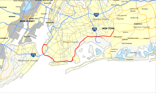
The Belt Parkway is the name given to a series of connected limited-access highways that form a belt-like circle around the New York City boroughs of Brooklyn and Queens. The Belt Parkway comprises three of the four parkways in what is known as the Belt System: the Shore Parkway, the Southern Parkway, and the Laurelton Parkway. The three parkways in the Belt Parkway are a combined 25.29 miles (40.70 km) in length. The Cross Island Parkway makes up the fourth parkway in the system, but is signed separately.

New Utrecht was a town in western Long Island, New York encompassing all or part of the present-day Bath Beach, Bay Ridge, Bensonhurst, Borough Park, Dyker Heights and Fort Hamilton neighborhoods of Brooklyn, New York City. New Utrecht was established in 1652 by Dutch settlers in the Dutch colony of New Netherland, the last of the original six towns to be founded in Kings County. New Utrecht ceased to exist in 1894 when it was annexed by the City of Brooklyn, and became part of the City of Greater New York when Brooklyn joined as a borough in 1898.

Bath Beach is a neighborhood in Brooklyn, New York City, United States. It is located at the southwestern edge of the borough on Gravesend Bay. The neighborhood borders Bensonhurst and New Utrecht to the northeast across 86th Street; Dyker Beach Park and Golf Course to the northwest across 14th Avenue; and Gravesend to the east across Stillwell Avenue.
Bay Parkway is a 2.7-mile (7.82 km) boulevard/parkway in the west portion of the New York City borough of Brooklyn.
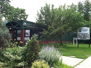
Alley Pond Park is the second-largest public park in Queens, New York City, occupying 655.3 acres (265.2 ha). The park is bordered to the east by Douglaston, to the west by Bayside, to the north by Little Neck Bay, and to the south by Union Turnpike. The Cross Island Parkway travels north-south through the park, while the Long Island Expressway and Grand Central Parkway travel east-west through the park. The park primarily consists of woodlands south of the Long Island Expressway and meadowlands north of the expressway. It is run and operated by the New York City Department of Parks and Recreation.

The B82 bus route constitutes a public transit line in central Brooklyn, New York City. It connects Starrett City in southeast Brooklyn with Coney Island on Brooklyn's southwestern coast. The B82 operates primarily via Kings Highway and Flatlands Avenue in southern Brooklyn. The route is operated by MTA Regional Bus Operations, under the New York City Bus and Select Bus Service brands.
Conduit Avenue is an arterial road in New York City, the vast majority of which is in Queens. The divided highway runs from Atlantic Avenue in Cypress Hills, Brooklyn to Hook Creek Boulevard in Rosedale, Queens at the Nassau County border. The thoroughfare is named after an aqueduct in its right-of-way.

Mapleton is a neighborhood in southern Brooklyn, New York City, bounded by 16th Avenue on the west, Dahill Road on the east, 57th Street on the north, and 65th Street on the south. It borders Bensonhurst and Borough Park to the west, and Midwood to the east.

The first Brooklyn Chinatown, was originally established in the Sunset Park area of the New York City borough of Brooklyn. It is one of the largest and fastest growing ethnic Chinese enclaves outside of Asia, as well as within New York City itself. As this Chinatown is rapidly evolving into an enclave predominantly of Fuzhou immigrants from Fujian Province in China, it is now increasingly common to refer to it as the Little Fuzhou or Fuzhou Town of the Western Hemisphere; as well as the largest Fuzhou enclave of New York City.

Cropsey Avenue is a major street in Brooklyn, New York City. It generally runs northwest-southeast, from Poly Place/14th Avenue in Bath Beach to Neptune Avenue/West 17th Street in Coney Island. It forms the northeastern boundary of Dreier-Offerman Park.

Lieutenant Joseph Petrosino Park is a New York City public park located in Bensonhurst, Brooklyn, New York City between 70th Street to the north, 71st Street to the south, 16th Avenue to the east, and New Utrecht Avenue to the west. It is on the east side of the 71st Street subway station. This part of Bensonhurst was within the Town of Nieuw Utrecht when it was founded during the Dutch colonial era in 1657. The town had its name Anglicized to New Utrecht during the English colonial era. The town lost its autonomous status and became part of the City of Brooklyn in 1894. Since 16th Avenue and New Utrecht Avenue do not run parallel to each other, the footprint of the park is trapezoidal in shape.
Seth Low Playground is a five-acre park located in the Bensonhurst neighborhood of Brooklyn. The park is named after Seth Low, a former Mayor of New York City and president of Columbia University. The City acquired this playground in 1924 as a park. Prior to this, it was the site of Indian Pond, a historical watering hole and ice skating location near the border of the former towns of New Utrecht and Gravesend. The park is bounded by Stillwell Avenue, Bay Parkway, West 12th Street and Avenue P. In 1896, the pond was filled with ash from a trash incinerator, covering it entirely.

Fort Hamilton Parkway is a parkway in Brooklyn, New York. It runs for 4.1 miles from the neighborhood of Windsor Terrace to Bay Ridge, its southern end at the entrance to its namesake military base at Fort Hamilton.

Spring Creek Park is a public park along the Jamaica Bay shoreline between the neighborhoods of Howard Beach, Queens, and Spring Creek, Brooklyn, in New York City. Created on landfilled former marshland, the park is mostly an undeveloped nature preserve, with only small portions accessible to the public for recreation.
Adventurer's Park is a small amusement park in the Bensonhurst section of Brooklyn in New York City. It is a concession located within the city-owned Nellie Bly Park, next to the Belt Parkway. The concession, also originally named Nellie Bly Park, features classic kiddie rides and arcade games as well as a Ferris wheel, go carts and miniature golf.

Calvert Vaux Park is an 85.53-acre (34.61 ha) public park in Gravesend, Brooklyn, in New York City. Created in 1934, it is composed of several disconnected sections along the Belt Parkway between Bay 44th and Bay 49th Streets. The peninsula upon which the park is located faces southwest into Gravesend Bay, immediately north of the Coney Island Creek. The park was expanded in the 1960s by waste from the construction of the Verrazzano-Narrows Bridge, and was renamed after architect Calvert Vaux in 1998. It is operated by the New York City Department of Parks and Recreation, also known as NYC Parks.
References
- ↑ "Bensonhurst Park". New York City Department of Parks and Recreation. Retrieved August 10, 2017.
- ↑ "Bensonhurst Park Playgrounds". New York City Department of Parks and Recreation. Retrieved August 10, 2017.
- ↑ "Bensonhurst Park Basketball Courts". New York City Department of Parks and Recreation. Retrieved August 10, 2017.
- ↑ "Bensonhurst Park Highlights". New York City Department of Parks and Recreation. Retrieved August 10, 2017.
- ↑ Silberstein, Rachel. "EXCLUSIVE: $6.5 Million In Renovations Coming To Bensonhurst Park". BKLYNER . Retrieved June 3, 2019.
- ↑ "Bensonhurst Park Is About To Get A Makeover". The Brooklyn Ink. September 12, 2016. Retrieved June 3, 2019.
- ↑ "Bensonhurst Park Playground Reconstruction". New York City Department of Parks and Recreation. Retrieved June 3, 2019.