Related Research Articles

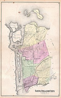
Long Island City (LIC) is a residential and commercial neighborhood on the extreme western tip of Queens, a borough in New York City. It is bordered by Astoria to the north; the East River to the west; New Calvary Cemetery in Sunnyside to the east; and Newtown Creek—which separates Queens from Greenpoint, Brooklyn—to the south.

St. Albans is a residential neighborhood in the southeastern portion of the New York City borough of Queens. It is bordered by Jamaica to the northwest, Hollis to the north, Queens Village to the northeast, Cambria Heights to the east, Laurelton to the southeast, Springfield Gardens to the south, and South Jamaica to the southwest. St. Albans is centered on the intersection of Linden Boulevard and Farmers Boulevard, about two miles north of John F. Kennedy International Airport.

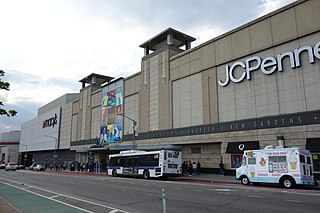
Flushing is a neighborhood in the north-central portion of the New York City borough of Queens. The neighborhood is the fourth-largest central business district in New York City. Downtown Flushing is a major commercial and retail area, and the intersection of Main Street and Roosevelt Avenue at its core is the third-busiest in New York City, behind Times Square and Herald Square.
Elmhurst is a neighborhood in the borough of Queens in New York City. It is bounded by Roosevelt Avenue on the north; the Long Island Expressway on the south; Junction Boulevard on the east; and the New York Connecting Railroad on the west.

Astoria is a neighborhood in the western portion of the New York City borough of Queens. Astoria is bounded by the East River and is adjacent to three other Queens neighborhoods: Long Island City to the southwest, Sunnyside to the southeast, and Woodside to the east. As of 2019, Astoria has an estimated population of 95,446.

Jamaica is a neighborhood in the New York City borough of Queens. It is mainly composed of a large commercial and retail area, though part of the neighborhood is also residential. Jamaica is bordered by Hollis to the east; St. Albans, Springfield Gardens, Rochdale Village to the southeast; South Jamaica to the south; Richmond Hill and South Ozone Park to the west; Briarwood to the northwest; and Kew Gardens Hills, Jamaica Hills, and Jamaica Estates to the north.

Woodside is a residential and commercial neighborhood in the western portion of the borough of Queens in New York City. It is bordered on the south by Maspeth, on the north by Astoria, on the west by Sunnyside, and on the east by Elmhurst, Jackson Heights, and East Elmhurst. Some areas are widely residential and very quiet, while other parts, especially the ones around Roosevelt Avenue, are busier.

Sunnyside is a neighborhood in the western portion of the New York City borough of Queens. It shares borders with Hunters Point and Long Island City to the west, Astoria to the north, Woodside to the east and Maspeth to the south. It contains the Sunnyside Gardens Historic District, one of the first planned communities in the United States.

Queens Botanical Garden is a botanical garden located at 43-50 Main Street in Flushing, Queens, New York City. The 39-acre (16 ha) site features rose, bee, herb, wedding, and perennial gardens; an arboretum; an art gallery; and a LEED-certified Visitor & Administration Building. Queens Botanical Garden is located on property owned by the City of New York, and is funded from several public and private sources. It is operated by Queens Botanical Garden Society, Inc.

East Elmhurst is a residential neighborhood in the northwest section of the New York City borough of Queens. It is bounded to the south by Jackson Heights and Corona, to the north and east by Bowery Bay, and to the west by Woodside and Ditmars Steinway. The area also includes LaGuardia Airport, located on the shore of Flushing Bay, LaGuardia Landing Lights Fields, and Astoria Heights.

Aviation High School, official name Aviation Career & Technical Education High School (24Q610), is public high school owned and operated by the New York City Department of Education. Formerly known as the Manhattan School of Aviation Trades (SAT), Aviation High School has operated since 1936.

Kew Gardens Hills is a neighborhood in the middle of the New York City borough of Queens. The borders are Flushing Meadows-Corona Park to the west, the Long Island Expressway to the north, Union Turnpike to the south, and Parsons Boulevard to the east.
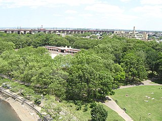
Astoria Park is a 59.96-acre (24.26 ha) public park in the Astoria neighborhood of Queens in New York City. The park is situated on the eastern shore of the Hell Gate, a strait of the East River, between Ditmars Boulevard to the north and Hoyt Avenue to the south. The Robert F. Kennedy (Triborough) and Hell Gate Bridges respectively pass over the park's southern and northern sections. Astoria Park contains a playground, a soccer field, a running track, a skate park, and courts for tennis, basketball, and bocce. Astoria Park also includes the Astoria Play Center, which consists of a recreation center and a pool. The park and play center are maintained by the New York City Department of Parks and Recreation.

Queens Metropolitan High School (QMHS) is a public high school in Forest Hills in Queens, New York. It is generally referred to simply as "QMHS," "Metro", or just "'Queens Metro" by the students. It is on the south side of Metropolitan Avenue in the Metropolitan Avenue Educational Campus at 91-30 Metropolitan Avenue, between a former Long Island Rail Road branch and 69th Avenue.
Flushing Fields is a public park in the northern section of the Flushing neighborhood of Queens in New York City. The site of this park was purchased by the Memorial Field of Flushing Corporation in 1921 at what was at the time open farmland. From its beginning, the park served as the home field for the softball, soccer, football and track teams from Flushing High School. The name of the park and monument at its southern section honor residents of Flushing killed in the First World War.
Vleigh Playground is a 2.243-acre park in Kew Gardens Hills, Queens, New York City. It takes its name from Head of the Vleigh Road, a colonial period path that ran along the northern boundary of the playground site. This path is presently followed by Vleigh Place and 70th Road. This road connected the town of Flushing to Brooklyn during colonial times, allowing travelers to circumvent Flushing Meadows, then an impassible swamp.

Judge Moses Weinstein Playground is a 3.25-acre triangular park located in the Kew Gardens Hills neighborhood of Queens, New York City.

Open Road Park is a small park in East Village, Manhattan, New York City, located east of First Avenue between 11th and 12th Streets. It is among the larger green spaces created in the East Village as a result of community organizing. The site of this park was taken over in 1993 by Open Road, a neighborhood nonprofit that developed the lot into a community garden and playground. Prior to its use as a park, the site was used for many purposes that reflect on the history of the surrounding neighborhood.
Foch Sitting Area is a 0.051-acre (210 m2) green public space in the South Jamaica neighborhood of Queens, New York, at the southeast corner of Foch Boulevard and the northbound service road of the Van Wyck Expressway. Like the adjacent Foch Boulevard, it is named after Ferdinand Foch, Marshal of France in World War I. The road, running between South Ozone Park and South Jamaica, was named following its completion in 1919.
Sunswick Creek is a buried stream located in Astoria and Long Island City, in the northwestern portion of Queens in New York City. It originated to the north of Queensboro Bridge and Queens Plaza in Long Island City, flowing north to the present-day site of the Socrates Sculpture Park in Astoria, and emptying into the East River. The creek was named for a term in the Algonquin language that likely means "Woman Chief" or "Sachem’s Wife."
References
- ↑ "Queens Historical Society Newsletter". Fall 1996.
- ↑ "City's Smallest Schoolhouse Doomed". Brooklyn Daily Eagle . June 28, 1910.
- ↑ Erickson, Charles (November 30, 2004). "Rekindling Memories". Newsday .
- ↑ Honan, Katie (July 17, 2015). "Park at Site of Last 1-Room Schoolhouse in Queens Gets $400K Boost". DNAinfo . Archived from the original on 2015-07-22.
- ↑ O'Brien, Shane (September 25, 2019). "Revamp of One Room Schoolhouse Park Begins, Work to be Done by Winter". Jackson Heights Post. Retrieved 2020-06-08.