Beverly Crest, Los Angeles

Last updated

Beverly Crest
Location map Western Los Angeles.png
Red pog.svg
Beverly Crest
Location within Los Angeles
Coordinates: 34°06′05″N118°24′59″W / 34.1015°N 118.4163°W / 34.1015; -118.4163
Country United States
State California
County Los Angeles
Time zone Pacific
Zip Code
90210
Area code 323

Beverly Crest is a neighborhood in the Santa Monica Mountains, in the Westside area of the city of Los Angeles, California.

Contents

History

Developer George Read purchased the 80-acre (32 ha) area in 1923. After the streets were paved and underground utilities and streetlights installed, development began in 1926. The land was subdivided into 178 parcels ranging in size from one-quarter to three-quarters of an acre. Two gatehouses (one of which remains) were constructed at the Schuyler Road entrance. Read installed a sign on the hillside (similar to the Hollywoodland sign) to market the neighborhood [1] as a community of "motion picture celebrities and other notables." [2]

On October 1, 2008, the City of Los Angeles approved the name of Beverly Crest for the neighborhood. [3]

Geography

Beverly Crest is east of Coldwater Canyon Drive and borders the city of Beverly Hills on the east, west and south. [1] According to the Crests Neighborhood Association, Beverly Crest consists of properties located on Lindacrest Drive, Readcrest Drive, Beverlycrest Drive, Lloydcrest Drive, Waynecrest Drive, Gilcrest Drive, Claircrest Drive, Ridgecrest Drive, Cerrocrest Drive, Meadow Drive and 1300-1631 Schuyler Road. [4]

Beverly Crest is included in the Bel Air–Beverly Crest Community Plan area of Los Angeles, which covers the neighborhoods of: Beverly Crest, Bel Air, Benedict Canyon, Beverly Glen, Laurel Canyon, and the northern portion of Holmby Hills). [5] [6] [7]

The name Beverly Crest was officially approved by the city to cover an area that includes the streets of Beverlycrest Drive, Cerrocrest Drive, Claircrest Drive, Gilcrest Drive, Lindacrest Drive, Lloydcrest Drive, Readcrest Drive, Ridgecrest Drive, Waynecrest and Schuyler Road. It lies in Los Angeles census tract 2611.01, block group 2 (as of 2008). [3] [8] The name "Beverly Crest" is sometimes used more broadly to refer to a larger section in the Bel Air–Beverly Crest Community Plan area, in the hills above the city of Beverly Hills. [9]

As mapped by Mapping L.A., the area of Beverly Crest is roughly triangular, with Sherman Oaks to the north, Bel Air to the southwest and the city of Beverly Hills to the southeast. The borders are mapped by the Los Angeles Times to run along Mulholland Drive on the north; Stone Canyon Road to the west, then Beverly Glen Boulevard below Stone Canyon Reservoir to Sunset Boulevard on the far south. The southeastern boundary with Beverly Hills is complex, and most of Beverly Crest lies within the so-called Beverly Hills Post Office, defined as ZIP code 90210 outside the city of Beverly Hills proper. The neighborhood of Hollywood Hills West is nearby on the east. [10]

Map of Beverly Crest as delineated by the Los Angeles Times Map of Beverly Crest neighborhood of Los Angeles, California.jpg
Map of Beverly Crest as delineated by the Los Angeles Times

Demographics

The following data applies to Beverly Crest within the boundaries established by Mapping L.A.:

The 2000 U.S. census counted 10,852 residents in the 8.24-square-mile Beverly Crest neighborhood—or 1,318 people per square mile, among the lowest population densities for the city and the county. In 2008, the city estimated that the population had increased to 11,569. In 2000 the median age for residents was 45, which was high for city and county neighborhoods. The percentages of residents aged 35 and older were among the county's highest. [10]

According to demographic surveys, in 2000 the median age of residents was 45 years old, which made Beverly Crest have one of the highest median ages for any of the neighborhoods in Los Angeles, behind only Century City and Bel-Air. [11]

The Los Angeles Times considered the neighborhood "not especially diverse" [12] ethnically within Los Angeles, given its relatively high percentage of Caucasian residents. The breakdown was whites, 87.5%; Asians, 4.0%; Latinos, 3.4%; blacks 1.7%; other races 3.3%. Iran (28.6%) and the United Kingdom (8.6%) were the most common places of birth for the 25% of the residents who were born abroad—which was an average percentage for Los Angeles as a whole. [10]

The median yearly household income in 2008 dollars was $169,282, considered high for the city and the county. Renters occupied 10% of the housing stock, and house- or apartment-owners held 90%. The average household size of 2.4 people was considered typical for Los Angeles. The 5.6% of families headed by single parents was low for city and county neighborhoods. The percentages of married people in Bel Air were among the county's highest—63.4% for men and 59.5% for women. There were 896 veterans, or 10.2% of the population, a high proportion compared to the rest of the city and county. [10]

More than two-thirds (67.6%) of Beverly Crest residents aged 25 and older had earned a four-year degree by 2000, a high percentage for the city and the county. The percentages of residents in that age range with a bachelor's degree or greater were high for the county. [10]

Notable residents

See also

Related Research Articles

<span class="mw-page-title-main">Beverly Hills, California</span> Urban City in California, United States

Beverly Hills is a city located in Los Angeles County, California, United States. A notable and historic suburb of Los Angeles, it is located immediately southwest of the Hollywood Hills, approximately 12.2 miles (19.6 km) northwest of downtown Los Angeles. Beverly Hills' land area totals to 5.71 square miles (14.8 km2), and is entirely surrounded by the city of Los Angeles. According to the 2020 census, the city has a population of 32,701; marking a decrease of 1,408 from the 2010 census count of 34,109.

<span class="mw-page-title-main">Westwood, Los Angeles</span> Neighborhood of Los Angeles in California, United States

Westwood is a commercial and residential neighborhood in the northern central portion of the Westside region of Los Angeles, California. It is the home of the University of California, Los Angeles (UCLA). Bordering the campus on the south is Westwood Village, a major regional district for shopping, dining, movie theaters, and other entertainment.

<span class="mw-page-title-main">Bel Air, Los Angeles</span> Neighborhood of Los Angeles, California

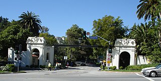
Bel Air is a residential neighborhood on the Los Angeles Westside, in the foothills of the Santa Monica Mountains in the U.S. state of California. Founded in 1923, it is the home of the Hannah Carter Japanese Garden and the American Jewish University.

<span class="mw-page-title-main">Los Feliz, Los Angeles</span> Neighborhood of Los Angeles in California, United States

Los Feliz is a hillside neighborhood in the greater Hollywood area of Los Angeles, California, abutting Hollywood and encompassing part of the Santa Monica Mountains. The neighborhood is named after the Feliz family of Californios who had owned the area since 1795, when José Vicente Feliz was granted Rancho Los Feliz.

<span class="mw-page-title-main">Century City</span> Neighborhood of Los Angeles in California, United States

Century City is a 176-acre neighborhood and business district in Los Angeles, California, United States. Located on the Westside to the south of Santa Monica Boulevard around 10 miles (16 km) west of Downtown Los Angeles, Century City is one of the most prominent employment centers in the Los Angeles metropolitan area, and its skyscrapers form a distinctive skyline on the city's westside.

<span class="mw-page-title-main">West Hills, Los Angeles</span> Neighborhood in Los Angeles, California, United States

West Hills is a suburban / residential community in the western San Fernando Valley region of the City of Los Angeles, California. The percentage of residents aged 35 and older is among the highest in Los Angeles County.

The Los Angeles Westside is an urban region in western Los Angeles County, California, United States. It has no official definition, but sources like LA Weekly and the Mapping L.A. survey of the Los Angeles Times place the region on the western side of the Los Angeles Basin south of the Santa Monica Mountains.

<span class="mw-page-title-main">Fairfax District, Los Angeles</span> Neighborhood of Los Angeles

The Fairfax District is a neighborhood in the Central region of Los Angeles, California.

West Los Angeles is an area within the city of Los Angeles, California, United States. The residential and commercial neighborhood is divided by the Interstate 405 freeway, and each side is sometimes treated as a distinct neighborhood, mapped differently by different sources. Each lies within the larger Westside region of Los Angeles County.

Porter Ranch is a suburban-type neighborhood of the City of Los Angeles in the northwest portion of the San Fernando Valley.

<span class="mw-page-title-main">Beverly Hills Post Office</span> Area of Los Angeles, California

Beverly Hills Post Office (BHPO) is the name given to a section of Los Angeles, California, that lies within the 90210 ZIP code, assigned to the Beverly Hills Post Office. Los Angeles mailing addresses with the ZIP code 90210 may be written as "Beverly Hills, CA 90210", though the properties themselves lie outside of the Beverly Hills city limits.

<span class="mw-page-title-main">Elysian Park, Los Angeles</span> Neighborhood in Los Angeles, California

Elysian Park is a neighborhood in Central Los Angeles, California, United States. The city park, Elysian Park, and Dodger Stadium are within the neighborhood, as are an all-boys Catholic high school and an elementary school.

Central Los Angeles is the historical urban region of the City of Los Angeles, California.

<span class="mw-page-title-main">South Robertson, Los Angeles</span> Neighborhood of Los Angeles in California, United States

South Robertson is an area on the Westside of Los Angeles that is served by the South Robertson neighborhood council. It contains the following city neighborhoods: Beverlywood, Castle Heights, Cheviot Hills, Crestview, La Cienega Heights and Reynier Village. The area is notable as a center for the Jewish community.

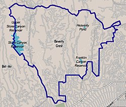
Beverly Glen is a neighborhood in the Santa Monica Mountains region of Los Angeles, California, located around Beverly Glen Boulevard north of Sunset Boulevard and south of Mulholland Drive. Stone Canyon Reservoir lies in the neighborhood.

Cheviot Hills is a neighborhood on the Westside of the city of Los Angeles, California.

Holmby Hills is a neighborhood on the Westside of Los Angeles, California, United States.

<span class="mw-page-title-main">Hollywood Hills West, Los Angeles</span>

Hollywood Hills West is a neighborhood within Central Los Angeles, California.

<span class="mw-page-title-main">Beverly Grove, Los Angeles</span> District and neighborhood of Los Angeles, California, US

Beverly Grove is an area within the Beverly–Fairfax neighborhood in the Mid-City West region of Los Angeles, California.

References

  1. 1 2 Los Angeles Department of City Planning. "Bel Air - Beverly Crest Districts" (PDF). Survey LA. p. 33. Retrieved January 11, 2021.
  2. Ryon, Ruth (June 1, 1986). "Rock Hudson's House Now on Market". Los Angeles Times .
  3. 1 2 "APPLICATION TO NAME A COMMUNITY BEVERLY CREST" (PDF). LACity.org. Retrieved January 11, 2021.
  4. "Crests Neighborhood Association". Archived from the original on September 16, 2017. Retrieved August 11, 2018.
  5. SurveyLA: Historic Resources Survey Report: Bel Air – Beverly Crest Community Plan Area
  6. Regular Meeting of the Board, Wednesday, January 27, 2016 7:00–9:00 P.M., Bel Air–Beverly Crest Neighborhood Council
  7. "About". Bel-Air/Beverly Crest Neighborhood Council. Archived from the original on October 3, 2011. Retrieved July 20, 2015.
  8. Council File: 08-0312, BEVERLY CREST / COMMUNITY NAMING AND RENAMING APPLICATION
  9. NAMING / RENAMING OF A COMMUNITY, REQUEST FOR DEPARTMENTAL EVALUATION, Report from City Planning to City Clerk, 2008-05-08. "Historical research indicates that the proposed name, 'Beverly Crest,' would accurately reflect the historical and cultural significance of the area. ... The Community Plan text does not include specific information on the history or boundaries of the area; however, historical research suggests that George E. Read originally named the area Beverly Crest when he began to subdivide the area in 1923. ... Further, the name 'Beverly Crest' is also geographically accurate because this area is located in the hills above the City of Beverly Hills, and is within the larger section of the Bel Air-Beverly Crest Community that is commonly referred to as 'Beverly Crest.'"
  10. 1 2 3 4 5 "Beverly Crest". Los Angeles Times . Mapping L.A. Retrieved July 20, 2015.
  11. "Median Age". Los Angeles Times . Mapping L.A. Retrieved July 20, 2015.
  12. "Diversity". Los Angeles Times . Mapping L.A. Retrieved July 20, 2015.
  13. 1 2 Chen, Joyce (May 6, 2020). "Hollywood Legend Rock Hudson's Former Home Hits the Market". architecturaldigest.com. Architectural Digest. Retrieved January 13, 2021.
  14. Rapattoni, Linda. "Private trust buys Hudson estate". United Press International. Retrieved January 13, 2021.
  15. Ryon, Ruth (July 19, 1987). "Buyer of Rock Hudson House Disclosed". Los Angeles Times . Retrieved January 13, 2021.
  16. Flemming, Jack (February 28, 2022). "Drake is buying Robbie Williams' Beverly Crest mansion for more than $70 million". Los Angeles Times. Retrieved March 1, 2022.