Bruce Highway | |
|---|---|
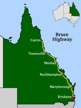 | |
Map of Queensland with Bruce Highway highlighted in yellow | |
| General information | |
| Type | Highway |
| Length | 1,679 km (1,043 mi) |
| Route number(s) |
|
| Major junctions | |
| North end | |
| |
| South end | |
| Location(s) | |
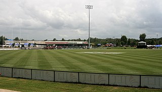
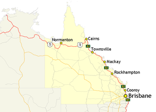
| Major settlements | Townsville, Mackay, Rockhampton, Maryborough, Gympie |
| Highway system | |

The Bruce Highway is a major highway in Queensland, Australia. Commencing in the state capital, Brisbane, it passes through areas close to the eastern coast on its way to Cairns in Far North Queensland. The route is part of the Australian National Highway and also part of Highway 1, the longest highway route in Australia. Its length is approximately 1,679 kilometres (1,043 mi); it is entirely sealed with bitumen. The highway is named after a popular former Queensland and federal politician, Harry Bruce. Bruce was the state Minister for Works in the mid-1930s when the highway was named after him. The highway once passed through Brisbane, but was truncated at Bald Hills when the Gateway Motorway became National Highway 1 upon its opening in December 1986.[ citation needed ]
Contents
- State-controlled road
- Route description
- Brisbane to Rockhampton
- Development of the M1
- History
- Remnants of early roads to the north of Brisbane
- Tom Petrie’s roads
- Upgrades
- Major upgrades: Bald Hills to Cooroy
- Major upgrades: Cooroy to Rockhampton
- Major upgrades: Rockhampton to Townsville
- Major upgrades: Townsville to Cairns
- Projects
- Northern Australian Beef Roads Upgrade
- Road train access to Rockhampton (stage 2)
- Highway towns
- Brisbane to Maryborough
- Maryborough to Rockhampton 2
- Rockhampton to Mackay
- Mackay to Townsville
- Townsville to Cairns
- Major intersections
- M1
- A1
- Route of former Bruce Highway through Townsville
- River crossings
- Queensland Electric Super Highway
- Precise locations
- Distances
- Phase 2
- Phase 3
- See also
- References
- External links
It was previously known as the Great North Coast Road, being renamed as the Bruce Highway in 1934 after the state's Minister for Public Works, Henry Bruce. [1]
The highway is the biggest traffic carrier in Queensland. It initially joined all the major coastal centres; however, a number of bypasses, particularly in the south, have diverted traffic around these cities to expedite traffic flow and ease urban congestion. As a result, the highway is constantly being shortened. The road is a dual carriageway from Brisbane to Kybong with some dual carriageway lengths at Gympie, many of these upgrades being completed in the 1980s (Glass House Mountains, Tanawha, Maryborough) and 1990s (Nambour, Yandina, and Cooroy).[ citation needed ]
The highway commences just south of the bridge over the Pine River at the Gateway Motorway interchange, 21 kilometres (13 mi) north of the Brisbane central business district. The highway has changed its route numbering from National Highway 1 to the M1 (motorway road) or A1 (single carriageway, generally with overtaking lanes).[ citation needed ]

Major cities along the route include Gympie, Maryborough, Rockhampton, Mackay, Townsville, and Cairns. The highway passes the Glasshouse Mountains, rainforests and pastures in the Sunshine Coast, the Gunalda Range (north of Gympie), Mount Larcom (north of Gladstone), and the arid countryside north of Rockhampton; after that, it passes through land predominantly used for sugar cane, crop growing and dairy farms and the sub-tropics and tropics.[ citation needed ]