The Sri Mariamman Temple is Singapore's oldest Hindu temple. It is an agamic temple, built in the Dravidian style. Located at 244 South Bridge Road, in the downtown Chinatown district, the temple serves the majority Hindu Singaporeans, Tamilians, in the city-state. Due to its architectural and historical significance, the temple has been gazetted a National Monument and is a major tourist attraction. Sri Mariamman Temple is managed by the Hindu Endowments Board, a statutory board under the Ministry of Community Development, Youth and Sports.

Tanjong Pagar is a historic district located within the Central Business District of Singapore, straddling the Outram Planning Area and the Downtown Core under the Urban Redevelopment Authority's urban planning zones. The district has a rich history and is known for its cultural and architectural landmarks, making it a popular tourist destination.
Bukit Merah, also known as Redhill, is a planning area and new town situated in the southernmost part of the Central Region of Singapore. the planning area borders Tanglin to the north, Queenstown to the west and the Downtown Core, Outram and Singapore River planning areas of the Central Area to the east.

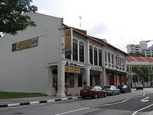
Jamae Mosque is one of the earliest mosques in Singapore, and is located on South Bridge Road in the Chinatown district within the Central Area. The mosque was established in 1826. This mosque is also known as Chulia Mosque and Periya Paḷḷi among the Tamil Muslim community in Singapore. Together with its neighbour, Sri Mariamman Temple, the mosque stands out in its predominantly Chinese location. The Mosque Street that runs beside it may have been named after this mosque.
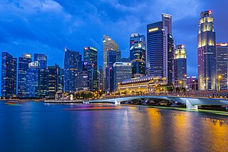
The Central Area, also called the City Area, and informally The City, is the main commercial city centre of Singapore. Located in the south-eastern part of the Central Region, the Central Area consists of eleven constituent planning areas: the Downtown Core, Marina East, Marina South, the Museum Planning Area, Newton, Orchard, Outram, River Valley, Rochor, the Singapore River and Straits View, as defined by the Urban Redevelopment Authority. The term Central Business District (CBD) has also been used to describe most of the Central Area as well, although its boundaries lie within the Downtown Core.

Jalan Besar Group Representation Constituency is a four-member Group Representation Constituency composed of several city suburbs along with the Central Area of Singapore. The Jalan Besar GRC is the electoral division representing the largest area of the downtown city centre of Singapore, followed by Tanjong Pagar GRC. There are four wards in the GRC: Kreta Ayer-Kim Seng, Kolam Ayer, Whampoa and lastly Kampong Glam. The current Members of Parliament are Denise Phua, Wan Rizal Wan Zakariah, Josephine Teo and Heng Chee How from the People's Action Party (PAP).

Masjid Al-Abrar is a mosque located along Telok Ayer Street in Chinatown within the Central Area, Singapore. It is one of the earliest mosques in Singapore.
Telok Ayer Chinese Methodist Church, is located on Telok Ayer Street within the Downtown Core of Singapore's central business district. The church is approximately 450 metres from Telok Ayer MRT station.

Telok Ayer Street is a street located in Singapore's Chinatown within the Outram district, linking Church Street to Cecil Street. Telok Ayer MRT station is located at the junction of Cross Street and this road.

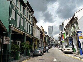
South Bridge Road is a major road in Singapore, running south of the Singapore River in Chinatown. It starts at Elgin Bridge and ends at the junction of Neil Road, Tanjong Pagar Road and Maxwell Road.

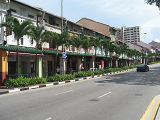
Pagoda Street is a street located in Chinatown within the Outram Planning Area in Singapore. The road links New Bridge Road and South Bridge Road, but has since been converted to a pedestrian mall to Chinatown MRT station at its New Bridge Road end.
Amoy Street is a one-way street located within Chinatown, within the Outram district in Singapore. The street is close to Tanjong Pagar MRT station.
Neil Road is a one-way road in Chinatown and Tanjong Pagar in the planning areas of Outram and Bukit Merah in Singapore. The road starts at the junction of South Bridge Road, Maxwell Road and Tanjong Pagar Road and ends at Kampong Bahru Road which then merges into Jalan Bukit Merah. At the end of the road, it is a conservation area of several shophouses and a three-story Victorian style school building, which was the former site of Fairfield Methodist Girls' School. In the Tanjong Pagar area of the road, it is home to rows of conserved shophouses for various purposes.

Kreta Ayer Road is a one-way road located in Chinatown within the Outram Planning Area in Singapore. The road links Neil Road to New Bridge Road and Eu Tong Sen Street, and is intersected by Keong Saik Road.

Tras Street is a street located in Tanjong Pagar in the Outram Planning Area and Downtown Core in Singapore. The road connects Enggor Street and Gopeng Street to Cook Street, and is intersected by Wallich Street.

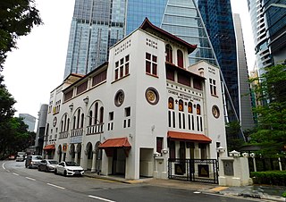
Duxton Hill is a small hill, as well as the name of a road, located in Tanjong Pagar in the Downtown Core district of Singapore.
Teban Gardens is a residential precinct located in Jurong East, Singapore. Immediately north of Pandan Reservoir, it comprises exclusively public housing built by the JTC Corporation and Housing and Development Board.

Commonwealth is a subzone of Queenstown, located in the central-western part of Singapore. It is named after the Commonwealth of Nations. Commonwealth consists of Housing and Development Board flats, and there is one primary school and a secondary school in the area, New Town Primary School and Queensway Secondary School. SBS Transit Bus Services 32, 51, 93, 100, 105, 111, 122, 123, 145, 147, 153, 186, 195, 196, 198, SMRT Buses Services 61, 961/961M & 970 and Tower Transit Singapore Service 855 passes through this area. The nearest Mass Rapid Transit station is Commonwealth MRT station. Amenities in the area include Blessed Sacrament Church, Faith Methodist Church, Masjid Mujahidin Mosque, Queenstown Community Centre, Queenstown Lutheran Church, Ridout Tea Garden, Shuang Long Shan Wu Shu Ancestral Hall, Sri Muneeswaran Temple and Tanglin Halt Food Centre and Market.

Kim Seng Road is a street in Singapore that runs along the upper-easternmost portion of the Bukit Merah-Central Area border. It was named after Peranakan philanthropist, Tan Kim Seng. Today, the boundaries of Kim Seng division are: Indus Road and Alexandra Canal in the north; Jalan Bukit Ho Swee in the south; Kim Seng Road and Outram Road in the east; and Lower Delta Road in the west.