Climate of Venezuela

Last updated

Temperature regimes of Venezuela Venezuela Temperature Regime.png
Temperature regimes of Venezuela

The Climate of Venezuela is characterized for being tropical and megathermal as a result of its geographical location near the Equator, but because of the topography and the dominant wind direction, several climatic types occur which can be the same as found in temperate latitudes, and even polar regions. Latitude exerts little influence on the Venezuelan While the coastal cities of Maracaibo, Barcelona, Porlamar and Maiquetia can get extremely hot, cities located at valleys such as Mérida, Caracas, Los Teques and San Cristobal have cooler climates, and the highest towns of Mucuchies and Apartaderos have cold (tundra) climates.

Contents

The hottest part of Venezuela is the northwest (Paraguana Peninsula and Guajira Peninsula), where temperatures of more than 38 °C (100 °F) are frequently recorded. The coldest part in the country are located in the highest areas of the Cordillera de Mérida, where temperatures lower than −2 °C (28 °F) are recorded. The Venezuelan Coastal Range and Guiana Highlands have average temperatures from 25 °C (77 °F) to 11 °C (52 °F), while the Llanos average temperature is over 23 °C (73 °F).

The highest temperature recorded was 42 °C (108 °F) in Machiques, [1] and the lowest temperature recorded was −11 °C (12 °F), it has been reported from an uninhabited high altitude at Páramo de Piedras Blancas (Mérida state), [2] even though no official reports exist, lower temperatures in the mountains of the Sierra Nevada de Mérida are known.

Climate zones according to Köppen

Koppen climate classification map of Venezuela. Venezuela Koppen.png
Köppen climate classification map of Venezuela.

According to the Köppen climate classification, Venezuela's climate types are: [3]

Group A: Tropical climates

It's the most prevalent and characteristic climate of the country. Maintaining temperatures above 18 °C (64 °F) and rainfall in most of the year:

It can be found throughout the country, dominating the Llanos and northern Guayana Region, as well as other parts of the country. It is dry between December and March with annual rainfall between 600 and 1,500 mm.

It is located in the Guayana Region, Orinoco Delta, west of Zulia, Andean and Coastal range foothills, Paria Peninsula and Barlovento region; with rainfall between 1,600 and 2,500 mm per year and a drought of just 45 days.

It's located south of Venezuela, Orinoco Delta, El Tamá area in west of Venezuela, and south of Maracaibo Lake. Rainfall exceeds 2,500 mm, not tending dry season.

Group B: Dry climates

This type of climate the evaporation exceeds precipitation. In Venezuela is typical of desert and arid coastal areas and with annual temperatures above 18 °C. The cold semiarid type can be found at elevated portions of the Andes.

It can be found in Guajira Peninsula, Paraguana Peninsula, Araya Peninsula and most of the Insular region.

It is located in the northern part of Zulia state, most of the area of Lara state and Falcón state, the coastal area, Insular region and some semi-arid areas in Venezuelan Andes.

It can be found locked at the temperate zones of high Andean valleys of Cordillera de Mérida.

Group C: Temperate climates

The monthly averages temperatures are below 22 °C (72 °F) but above 0 °C (32 °F). At least one month's average temperature is below 18 °C (64 °F):

It tends to experience noticeably drier weather during the lower-sun "winter" season. It's located in the medium areas of the southern-east slope of Cordillera de Mérida and Sierra de Perija, the highest areas of south-western Venezuelan coastal range.

This climate doesn't tend to has a dry season. It's located in the medium areas of the Cordillera de Mérida and Sierra de Perija, the highest areas of Venezuelan coastal range, and the top of the highest Guiana Highlands Tepuis.

Group E: Alpine climates

It's characterized by average temperatures below 10 °C in all 12 months of the year:

Also known as páramo climate, this climate often undergo a sudden and drastic change in daily-weather in which they fluctuate between temperatures from below freezing to as high as 20 °C. Mean annual temperatures range from 2 °C (36 °F) to 10 °C (50 °F). It is located above the 3,000 m in the Sierra de Perija and Cordillera de Mérida. The most popular village with this climate in the country is the town of Apartaderos [4]

This climate is reserved to the highest peaks of the Venezuelan Andes, such as Pico Bolívar, Pico Humboldt, [

Climate zones according to altitude

Venezuelan climatic types, according to their thermal floors. ClimateZones Venezuela.png
Venezuelan climatic types, according to their thermal floors.

Venezuelan climates are structured in "thermal floors", as mentioned next: [5] [6]

Very Hot

This climate is characterized by very hot temperatures above 26 °C (79 °F), with precipitations that ranges from dry (less than 300 mm) to pluvial (more than 3300 mm) conditions. This climate can be found in areas below 300 m in sedimentary basins and lowlands such as the Llanos, Orinoco Delta, Maracaibo Basin, Orinoco Basin, and coastal plains and islands; it comprises almost all the country. This climate zone is present in cities like Maracaibo, Punto Fijo, Ciudad Guayana, Porlamar, Puerto La Cruz, Barinas, Tucupita, Cumaná, Maturin, Anaco, Ciudad Bolívar, Cabimas, El Vigía and others.

Warm

Warm climate can be found between 300 and 650 m. It's characterized by temperatures from 23 °C (73 °F) to 26 °C (79 °F) and precipitations that ranges from scarcely rainy (300 – 700 mm) to pluvial (more than 3300 mm) conditions. This climate can be found in lower foothills and plateaus in the Guiana Highlands, Venezuelan Coastal Range, Coro region and Venezuelan Andes. Cities which have this climate zone are Barquisimeto, Maracay, Valencia, Guarenas-Guatire, San Juan de Los Morros, Charallave, Valera, Barinitas, San Antonio del Táchira, Quibor and others.

Cool

This climate features temperatures between 18 °C (64 °F) to 23 °C (73 °F) and precipitations that ranges from scarcely rainy (300 – 700 mm) to pluvial (more than 3300 mm) conditions. It can be found in the country's mountainous areas between 650 and 1,350-1,600 m This climate zone is present in cities like Mérida, San Cristóbal, Caracas, Sanare, Villa de Cura, Ejido, Trujillo, Escuque, Rubio, Tovar, Boconó, Duaca, Bejuma, Los Teques, Nirgua, Santa Elena de Uairen, among others.

Mild/Temperate

Mild or Temperate climate can be found in the mountainous areas between 1,350-1,600 to 2,400 m. It features temperatures around 13 °C (55 °F) to 18 °C (64 °F) and precipitations that ranges from scarcely rainy (300 – 700 mm) to pluvial (more than 3300 mm) conditions. This climate zone is present in cities like Mérida (higher part), Colonia Tovar, San Antonio de Los Altos, El Jarillo, El Junquito, Galipan, Timotes, La Grita, Tabay, La Mucuy and others; most of the top of the tepuis also present this climate.

Cold

This climate is characterized by temperatures above 8 °C (46 °F) and below 13 °C (55 °F), with precipitations that ranges from scarcely rainy (300 – 700 mm) to pluvial (more than 3300 mm) conditions. This climate can be found in mountainous areas around 2,400 to 3,200 m specifically in Sierra de Perija, Cordillera de Mérida, higher elevations at Venezuelan Coastal Range and higher tepuis (Monte Roraima, Kukenan, Cerro Marahuaca, Chimantá Massif). This climate zone is present in towns like Mucuchíes, Chachopo and Los Nevados.

Very Cold

This climate can be found in the Venezuelan Andes area, between 3,200 and 4,150 m. It's characterized by temperatures from 3 °C (37 °F) to 8 °C (46 °F) and precipitations that ranges from scarcely rainy (300 – 700 mm) to rainy (1800–2500 mm) conditions. This climate zone is present in towns like Apartaderos and Llano del Hato. The condition of this climate is also known as páramo

Frosty

Frosty climate is found at the highest areas in Venezuelan Andes, between 4,150 and 4,700 m. where the temperatures are between 0 °C (32 °F) to 3 °C (37 °F). This climate zone is present exclusively at Sierra Nevada de Mérida, Sierra de La Culata and Sierra de Santo Domingo.

Glacial

This climate is characterized by average temperatures below 0 °C (32 °F) all year, it's located in the highest peaks of Venezuela in the Cordillera de Mérida such as Pico Bolívar, Pico Humboldt, Pico La Concha, Pico Bonpland, Pico Espejo, Pico Mucuñuque and Pico Piedras Blancas. Only Pico Bolivar and Pico Humboldt have their glaciers preserved, while the other peaks are exposed to nival zone conditions.


See also

Related Research Articles

<span class="mw-page-title-main">Geography of Colombia</span> Overview of the geography of Colombia

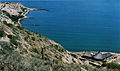
The Republic of Colombia is situated largely in the north-west of South America, with some territories falling within the boundaries of Central America. It is bordered to the north-west by Panama; to the east by Brazil and Venezuela; to the south by Ecuador and Peru; and it shares maritime limits with Costa Rica, Nicaragua, Honduras, Jamaica, the Dominican Republic, and Haiti.

<span class="mw-page-title-main">Geography of the Dominican Republic</span>

The Dominican Republic is a country in the West Indies that occupies the eastern five-eighths of Hispaniola. It has an area of 48,670 km2, including offshore islands. The land border shared with Haiti, which occupies the western three-eighths of the island, is 376 km long. The maximum length, east to west, is 390 km from Punta de Agua to Las Lajas, on the border with Haiti. The maximum width, north to south, is 265 km from Cape Isabela to Cape Beata. The capital, Santo Domingo, is located on the south coast.

<span class="mw-page-title-main">Geography of Ecuador</span>

Ecuador is a country in western South America, bordering the Pacific Ocean at the Equator, for which the country is named. Ecuador encompasses a wide range of natural formations and climates, from the desert-like southern coast to the snowcapped peaks of the Andes mountain range to the plains of the Amazon Basin. Cotopaxi in Ecuador is one of the world's highest active volcanos. It also has a large series of rivers that follow the southern border and spill into the northwest area of Peru.

<span class="mw-page-title-main">Mediterranean climate</span> Type of climate

A Mediterranean climate, also called a dry summer climate, described by Köppen as Cs, is a temperate climate type that occurs in the lower mid-latitudes. Such climates typically have dry summers and wet winters, with summer conditions ranging from warm to hot and winter conditions typically being mild to cool. These weather conditions are typically experienced in the majority of Mediterranean-climate regions and countries, but remain highly dependent on proximity to the ocean, altitude and geographical location.

<span class="mw-page-title-main">Köppen climate classification</span> Climate classification system

The Köppen climate classification is one of the most widely used climate classification systems. It was first published by German-Russian climatologist Wladimir Köppen (1846–1940) in 1884, with several later modifications by Köppen, notably in 1918 and 1936. Later, German climatologist Rudolf Geiger (1894–1981) introduced some changes to the classification system in 1954 and 1961, which is thus sometimes called the Köppen–Geiger climate classification.

<span class="mw-page-title-main">Oceanic climate</span> Climate classification

An oceanic climate, also known as a marine climate, is the temperate climate sub-type in Köppen classification represented as Cfb, typical of west coasts in higher middle latitudes of continents, generally featuring cool summers and mild winters, with a relatively narrow annual temperature range and few extremes of temperature. Oceanic climates can be found in both hemispheres generally between 45 and 63 latitude. Other varieties of climates usually classified together with these include subtropical highland climates, represented as Cwb or Cfb, and subpolar oceanic or cold subtropical highland climates, represented as Cfc or Cwc. Subtropical highland climates occur in some mountainous parts of the subtropics or tropics, some of which have monsoon influence, while their cold variants and subpolar oceanic climates occur near polar or tundra regions.

<span class="mw-page-title-main">Argentine Northwest</span>

The Argentine Northwest is a geographic and historical region of Argentina composed of the provinces of Catamarca, Jujuy, La Rioja, Salta, Santiago del Estero and Tucumán.

<span class="mw-page-title-main">Cordillera de Mérida</span> Series of mountain ranges in Venezuela

The Cordillera de Mérida is a series of mountain ranges, or massif, in northwestern Venezuela. The Cordillera de Mérida is a northeastern extension of the Andes Mountains and the most important branch of the Venezuelan Andes. The ranges run southwest–northeast between the Venezuelan-Colombian border and the Venezuelan Coastal Ranges. The Táchira depression separates the Cordillera de Mérida from the Cordillera Oriental, which forms the Colombia-Venezuela border.

<span class="mw-page-title-main">Apartaderos</span> Place in Mérida, Venezuela

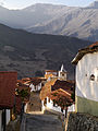
Apartaderos is a small Andean town in Mérida State, Venezuela.

<span class="mw-page-title-main">Sierra Nevada de Mérida</span>

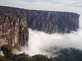
The Sierra Nevada de Mérida is the highest mountain range in the largest massif in Venezuela, the Cordillera de Mérida, which in turn is part of the northern extent of the Cordillera de los Andes. The Sierra Nevada de Mérida includes the highest peaks in Venezuela, Pico Bolívar, which has an elevation of 4,981 metres (16,342 ft), Pico Humboldt, Pico Bonpland and others.

<span class="mw-page-title-main">Climate of Colombia</span> Tropical and isothermal

The Climate of Colombia is characterized for being tropical and isothermal as a result of its geographical location near the Equator presenting variations within five natural regions and depending on the altitude, temperature, humidity, winds and rainfall. Each region maintains an average temperature throughout the year only presenting variables determined by precipitation during a rainy season caused by the Intertropical Convergence Zone.

<span class="mw-page-title-main">Climate of the United States</span> Varies due to changes in latitude, and a range of geographic features

The climate of the United States varies due to changes in latitude, and a range of geographic features, including mountains and deserts. Generally, on the mainland, the climate of the U.S. becomes warmer the further south one travels, and drier the further west, until one reaches the West Coast.

<span class="mw-page-title-main">Climate of Chile</span>

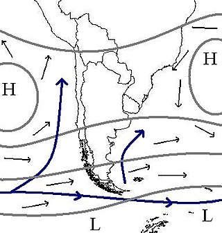
The climate of Chile comprises a wide range of weather conditions across a large geographic scale, extending across 38 degrees in latitude, making generalizations difficult. According to the Köppen system, Chile within its borders hosts at least seven major climatic subtypes, ranging from low desert in the north, to alpine tundra and glaciers in the east and southeast, tropical rainforest in Easter Island, Oceanic in the south and Mediterranean climate in central Chile. There are four seasons in most of the country: summer, autumn, winter, and spring.

<span class="mw-page-title-main">Climate of Argentina</span> Climate of the country

The climate of Argentina varies from region to region, as the vast size of the country and wide variation in altitude make for a wide range of climate types. Summers are the warmest and wettest season in most of Argentina except in most of Patagonia where it is the driest season. Warm in the north, cool in the center and cold in the southern parts experiencing frequent frost and snow. Because southern parts of the country are moderated by the surrounding oceans, the cold is less intense and prolonged than areas at similar latitudes in the northern hemisphere. Spring and autumn are transition seasons that generally feature mild weather.

<span class="mw-page-title-main">Climate of Mexico</span> Overview of the climate of Mexico

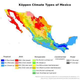
The climate of Mexico is very varied. The Tropic of Cancer effectively divides the country into temperate and tropical zones. Land that is north of the twenty-fourth parallel experiences lower temperatures during the winter months. South of the twenty-fourth parallel, temperatures are fairly consistent all year round and vary solely as a function of elevation. The north of the country usually receives less precipitation than the south.

<span class="mw-page-title-main">Sierra Nevada National Park (Venezuela)</span> Venezuelan National Park

The Sierra Nevada National Park (PNSN) is an important National Park of Venezuela located between Mérida and Barinas states in the west of the country. It was created on May 2, 1952, by decree of President Germán Suárez Flamerich, in order to protect the Sierra Nevada de Mérida in the Andes.

<span class="mw-page-title-main">Trewartha climate classification</span> Categorical system for longer-range recurrent weather patterns of Earth, orig. 1966

The Trewartha climate classification (TCC) or the Köppen–Trewartha climate classification (KTC) is a climate classification system first published by American geographer Glenn Thomas Trewartha in 1966. It is a modified version of the Köppen–Geiger system, created to answer some of its deficiencies. The Trewartha system attempts to redefine the middle latitudes to be closer to vegetation zoning and genetic climate systems.

<span class="mw-page-title-main">Climatic regions of Argentina</span> Overview of climatic regions of Argentina

Due to its vast size and range of altitudes, Argentina possesses a wide variety of climatic regions, ranging from the hot subtropical region in the north to the cold subantarctic in the far south. The Pampas region lies between those and featured a mild and humid climate. Many regions have different, often contrasting, microclimates. In general, Argentina has four main climate types: warm, moderate, arid, and cold in which the relief features, and the latitudinal extent of the country, determine the different varieties within the main climate types.

<span class="mw-page-title-main">Cordillera de Merida páramo</span> Ecoregion in the Andes mountain range of Venezuela

The Cordillera de Merida páramo (NT1004) is an ecoregion containing páramo vegetation above the treeline in the Andes mountain range of Venezuela. The isolated habitat has many endemic species. It is relatively stable and intact.

<span class="mw-page-title-main">Highland temperate climate</span>

The highland temperate climates are a temperate climate sub-type, although located in tropical zone, isothermal and with characteristics different from others temperate climates like oceanic or mediterranean where they are often are included without proper differentiation.

References

  1. "Extreme High Temperature in Venezuela". wunderground. Archived from the original on 20 September 2014. Retrieved 16 October 2012.
  2. "Extreme Low Temp in Venezuela". Wunderground. Archived from the original on 6 July 2013. Retrieved 16 October 2012. NOTE: Pass the cursor over the subrayed record to see the source of this. "This location is probably uninhabited, but is close to the town of San Isidro de Apartaderos. −11 °C (12 °F) has been reported from an uninhabited high altitude at Páramo de Piedras Blancas, Mérida state."
  3. "Tipos Climáticos". Venezuela Virtual. Archived from the original on 2 September 2012. Retrieved 5 August 2016.{{cite web}}: CS1 maint: bot: original URL status unknown (link)
  4. Sanchez Davila, Gabriel. "Sierra de Santo Domingo: Biogeographic reconstructions for the Quaternary of a former snowy mountain range". Academia (in Spanish). p. 51. Retrieved 5 July 2019.
  5. Silva, Gustavo (2010). Tipos y subtipos climáticos de Venezuela (PDF) (in Spanish). Universidad de Los Andes. Retrieved 5 August 2016.
  6. Silva, Gustavo (2002). "Classification of thermal floors in Venezuela" (PDF). Revista Geográfica Venezolana (in Spanish). 43 (2): 311–328. Retrieved 5 August 2016.