
The national parks of Venezuela are protected areas in Venezuela covering a wide range of habitats. In 2007 there were 43 national parks, covering 21.76% of Venezuela's territory.[ citation needed ]
The national parks of Venezuela are protected areas in Venezuela covering a wide range of habitats. In 2007 there were 43 national parks, covering 21.76% of Venezuela's territory.[ citation needed ]
Every Venezuela state has one or more national parks.
18 national parks are over 1000 km2; 15 over 2000 km2; 5 over 5000 km2 and 3 over 10,000 km2. The largest parks, in the Guayana Region, are Parima Tapirapecó National Park (39,000 km2) and Canaima National Park (30,000 km2).

Bolívar is one of the 23 states into which Venezuela is divided. The state capital city is Ciudad Bolívar, but the largest city is Ciudad Guayana. Bolívar State covers a total surface area of 242,801 km2 (93,746 sq mi) and as of the 2011 census, had a population of 1,410,964. The state contains Angel Falls.
La Gran Sabana is a region in southeastern Venezuela, part of the Guianan savanna ecoregion.

Pico Bolívar is the highest mountain in Venezuela, at 4,978 metres (16,332 ft). Located in Mérida State, its top is permanently covered with névé snow and three small glaciers. It can be reached only by walking; the Mérida cable car, which was the highest and longest cable car in the world when it was built, only reaches Pico Espejo. From there it is possible to climb to Pico Bolívar. The peak is named after the Venezuelan independence hero Simón Bolívar.

Henri Pittier National Park is the oldest national park in Venezuela, originally created in 1937 under the name of Rancho Grande by decree of President Eleazar López Contreras. In 1953 the park was renamed in honor of Henri Pittier, a distinguished Swiss geographer, botanist and ethnologist, who arrived in Venezuela in 1917, classified more than 30,000 plants in the country and devoted many years studying the flora and fauna in the park.

The Guayana Region is an administrative region of eastern Venezuela.

The Los Roques Archipelago is a federal dependency of Venezuela consisting of approximately 350 islands, cays, and islets in a total area of 40.61 square kilometers. The archipelago is located 128 kilometers (80 mi) directly north of the port of La Guaira, in the Caribbean Sea.

Mérida, officially known as Santiago de los Caballeros de Mérida, is the capital of the municipality of Libertador and the state of Mérida, and is one of the main cities of the Venezuelan Andes. It was founded in 1558 by Captain Juan Rodríguez Suárez, forming part of Nueva Granada, but later became part of the Captaincy General of Venezuela and played an active role in the War of Independence.
Upuigma-tepui, also known as El Castillo, is a tepui in Bolívar state, Venezuela. A relatively isolated peak, both it and nearby Angasima-tepui lie just south of the vast Chimantá Massif, from which they are separated by the Río Aparurén valley. Upuigma-tepui is situated entirely within the bounds of Canaima National Park.
The Tamá National Natural Park is a national park located in the Tamá Massif of the Andean Region of Colombia, between the municipalities Toledo and Herrán, in the department of Norte de Santander, in the northeastern part of the Eastern Ranges of the Colombian Andes. One of the main attractions of the park is a 820-metre-high (2,690 ft) waterfall, one of the world's highest.

Tourism in Venezuela has been developed considerably for decades, particularly because of its geographical position, the variety of landscapes, the richness of plants and wildlife, the artistic expressions and the privileged tropical climate of the country, which affords each region throughout the year. Since 2013 the country is having a very severe economic and political crisis affecting tourism all over the country.
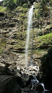
The El Guache National Park Is a protected area with the status of national park in Venezuela, located at the beginning of the Andes mountain range, comprising mountainous parts of the Lara and Portuguesa states, and the birth of the Guache, Ospino, Toco, Morador and Are rivers. 2 In its adjacencies is the mighty waterfall San Miguel. It has an area of 12,200 ha traditionally measured and 15,960 Ha. Its temperature is between 19 °C. and 26 °C. Precipitation varies between 1800 and 2000 mm annually.

Tirgua National Park, also known as General Manuel Manrique National Park, is a national park in Venezuela. It protects the headwaters of several waterways, especially the river Tirgua, which gives its name to the park.

The General Juan Pablo Peñaloza National Park Also Páramos Batallón y La Negra National Park Is a national park of Venezuela that is formed by several páramos: Among them Batallón and La Negra, which are an important source of water supply. It is located between the states Mérida and Táchira, northwest of the Táchira depression in the Páramos de El Batallón and La Negra in Venezuela.

The El Tamá National Park It is a protected area with the status of a national park that is located between the Andes and plains of Venezuela. It protects part of the Tamá Massif. It has an area of 139,000 hectares and is located in the states of Táchira and Apure, near the border with Colombia. Created as a National Park on December 12, 1978, by the then President Carlos Andrés Pérez.

The Aguaro-Guariquito National Park, also rendered as Aguaro Guariquito National Park, is a protected area with the status of national park in the South American country of Venezuela. Located in the region of the Llanos, it extends over the municipalities of Francisco de Miranda and Jose Rondon in Guárico state.

The Laguna de Tacarigua National Park Also Tacarigua Lagoon National Park Is a protected area with the status of a national park located east of Miranda State, in the South American country of Venezuela. It comprises a permanent coastal lagoon of 7800 ha and 1.2 m of average depth, separated from the sea by a restinga or coastal barrier of 28.8 km long and 300–1000 m wide that was formed by the action of the sea current Which runs along the coast in an East-West direction.

The Formaciones de Tepuyes Natural Monument also known as tepui Also Formaciones de Tepuyes Is a protected natural space since 1991, located in Venezuela more specifically in the states of Amazonas and Bolívar. Should not be confused with the Canaima national park that contains part of the tepuyes.
The Abra de Río Frío Natural Monument Is a protected natural space located in the municipality of San Cristóbal, in the state of Táchira, Venezuela. Received the status of natural monument on February 18, 1993.
The Loefling Zoo Also Zoological Park Loefling Is a publicly owned zoological garden located southwest of Cachamay Park, in Ciudad Guayana, part of the Bolivar State in the Venezuelan Guayana region. It received its name in honor of the Swedish botanist Pehr Löfling. He was one of the first to make the fauna and flora of this region known to science, and he died near Ciudad Guayana.

The Caura National Park is a protected area with the status of National Park in Venezuela. With an area of 7,534,000 ha. (75,340 km2) it is the largest park in the country and the most recently created (2017).
| Wikivoyage has a travel guide for National parks of Venezuela . |
| Wikimedia Commons has media related to National parks of Venezuela . |


