Related Research Articles
Human geography or anthropogeography is the branch of geography which studies spatial relationships between human communities, cultures, economies, and their interactions with the environment, examples of which include urban sprawl and urban redevelopment. It analyzes spatial interdependencies between social interactions and the environment through qualitative and quantitative methods.
Social statistics is the use of statistical measurement systems to study human behavior in a social environment. This can be accomplished through polling a group of people, evaluating a subset of data obtained about a group of people, or by observation and statistical analysis of a set of data that relates to people and their behaviors.

The First Law of Geography, according to Waldo Tobler, is "everything is related to everything else, but near things are more related than distant things." This first law is the foundation of the fundamental concepts of spatial dependence and spatial autocorrelation and is utilized specifically for the inverse distance weighting method for spatial interpolation and to support the regionalized variable theory for kriging. The first law of geography is the fundamental assumption used in all spatial analysis.

The quantitative revolution (QR) was a paradigm shift that sought to develop a more rigorous and systematic methodology for the discipline of geography. It came as a response to the inadequacy of regional geography to explain general spatial dynamics. The main claim for the quantitative revolution is that it led to a shift from a descriptive (idiographic) geography to an empirical law-making (nomothetic) geography. The quantitative revolution occurred during the 1950s and 1960s and marked a rapid change in the method behind geographical research, from regional geography into a spatial science.

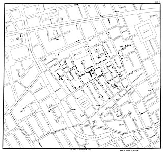
Spatial analysis is any of the formal techniques which studies entities using their topological, geometric, or geographic properties. Spatial analysis includes a variety of techniques using different analytic approaches, especially spatial statistics. It may be applied in fields as diverse as astronomy, with its studies of the placement of galaxies in the cosmos, or to chip fabrication engineering, with its use of "place and route" algorithms to build complex wiring structures. In a more restricted sense, spatial analysis is geospatial analysis, the technique applied to structures at the human scale, most notably in the analysis of geographic data. It may also be applied to genomics, as in transcriptomics data.

The modifiable areal unit problem (MAUP) is a source of statistical bias that can significantly impact the results of statistical hypothesis tests. MAUP affects results when point-based measures of spatial phenomena are aggregated into spatial partitions or areal units as in, for example, population density or illness rates. The resulting summary values are influenced by both the shape and scale of the aggregation unit.
Geomorphometry, or geomorphometrics, is the science and practice of measuring the characteristics of terrain, the shape of the surface of the Earth, and the effects of this surface form on human and natural geography. It gathers various mathematical, statistical and image processing techniques that can be used to quantify morphological, hydrological, ecological and other aspects of a land surface. Common synonyms for geomorphometry are geomorphological analysis, terrain morphometry, terrain analysis, and land surface analysis. Geomorphometrics is the discipline based on the computational measures of the geometry, topography and shape of the Earth's horizons, and their temporal change. This is a major component of geographic information systems (GIS) and other software tools for spatial analysis.

Geography is the study of the lands, features, inhabitants, and phenomena of Earth. Geography is an all-encompassing discipline that seeks an understanding of Earth and its human and natural complexities—not merely where objects are, but also how they have changed and come to be. While geography is specific to Earth, many concepts can be applied more broadly to other celestial bodies in the field of planetary science. Geography has been called "a bridge between natural science and social science disciplines."
Geographic information systems (GISs) and geographic information science (GIScience) combine computer-mapping capabilities with additional database management and data analysis tools. Commercial GIS systems are very powerful and have touched many applications and industries, including environmental science, urban planning, agricultural applications, and others.
A boundary problem in analysis is a phenomenon in which geographical patterns are differentiated by the shape and arrangement of boundaries that are drawn for administrative or measurement purposes. The boundary problem occurs because of the loss of neighbors in analyses that depend on the values of the neighbors. While geographic phenomena are measured and analyzed within a specific unit, identical spatial data can appear either dispersed or clustered depending on the boundary placed around the data. In analysis with point data, dispersion is evaluated as dependent of the boundary. In analysis with areal data, statistics should be interpreted based upon the boundary.
Quantitative geography is a subfield and methodological approach to geography that develops, tests, and uses scientific, mathematical, and statistical methods to analyze and model geographic phenomena and patterns. It aims to explain and predict the distribution and dynamics of human and physical geography through the collection and analysis of quantifiable data. The approach quantitative geographers take is generally in line with the scientific method, where a falsifiable hypothesis is generated, and then tested through observational studies. This has received criticism, and in recent years, quantitative geography has moved to include systematic model creation and understanding the limits of their models. This approach is used to study a wide range of topics, including population demographics, urbanization, environmental patterns, and the spatial distribution of economic activity. The methods of quantitative geography are often contrasted by those employed by qualitative geography, which is more focused on observing and recording characteristics of geographic place. However, there is increasing interest in using combinations of both qualitative and quantitative methods through mixed-methods research to better understand and contextualize geographic phenomena.
The second law of geography, according to Waldo Tobler, is "the phenomenon external to a geographic area of interest affects what goes on inside." This is an extension of his first. He first published it in 1999 in reply to a paper titled "Linear pycnophylactic reallocation comment on a paper by D. Martin" and then again in response to criticism of his first law of geography titled "On the First Law of Geography: A Reply." Much of this criticism was centered on the question of if laws were meaningful in geography or any of the social sciences. In this document, Tobler proposed his second law while recognizing others have proposed other concepts to fill the role of 2nd law. Tobler asserted that this phenomenon is common enough to warrant the title of 2nd law of geography. Unlike Tobler's first law of geography, which is relatively well accepted among geographers, there are a few contenders for the title of the second law of geography. Tobler's second law of geography is less well known but still has profound implications for geography and spatial analysis.
Technical geography is the branch of geography that involves using, studying, and creating tools to obtain, analyze, interpret, understand, and communicate spatial information. The other branches, most commonly limited to human geography and physical geography, can usually apply the concepts and techniques of technical geography. However, the methods and theory are distinct, and a technical geographer may be more concerned with the technological and theoretical concepts than the nature of the data. Further, a technical geographer may explore the relationship between the spatial technology and the end users to improve upon the technology and better understand the impact of the technology on human behavior. Thus, the spatial data types a technical geographer employs may vary widely, including human and physical geography topics, with the common thread being the techniques and philosophies employed. To accomplish this, technical geographers often create their own software or scripts, which can then be applied more broadly by others. They may also explore applying techniques developed for one application to another unrelated topic, such as applying Kriging, originally developed for mining, to disciplines as diverse as real-estate prices. In teaching technical geography, instructors often need to fall back on examples from human and physical geography to explain the theoretical concepts. While technical geography mostly works with quantitative data, the techniques and technology can be applied to qualitative geography, differentiating it from quantitative geography. Within the branch of technical geography are the major and overlapping subbranches of geographic information science, geomatics, and geoinformatics.

The uncertain geographic context problem or UGCoP is a source of statistical bias that can significantly impact the results of spatial analysis when dealing with aggregate data. The UGCoP is very closely related to the Modifiable areal unit problem (MAUP), and like the MAUP, arises from how we divide the land into areal units. It is caused by the difficulty, or impossibility, of understanding how phenomena under investigation in different enumeration units interact between enumeration units, and outside of a study area over time. It is particularly important to consider the UGCoP within the discipline of time geography, where phenomena under investigation can move between spatial enumeration units during the study period. Examples of research that needs to consider the UGCoP include food access and human mobility.

Spatial neural networks (SNNs) constitute a supercategory of tailored neural networks (NNs) for representing and predicting geographic phenomena. They generally improve both the statistical accuracy and reliability of the a-spatial/classic NNs whenever they handle geo-spatial datasets, and also of the other spatial (statistical) models whenever the geo-spatial datasets' variables depict non-linear relations.
Qualitative geography is a subfield and methodological approach to geography focusing on the subjective and interpretive aspects of human experiences and world perceptions. It is concerned with understanding the lived experiences of individuals and groups and the social, cultural, and political contexts in which those experiences occur. Thus, qualitative geography is traditionally placed under the branch of human geography; however, technical geographers are increasingly directing their methods toward interpreting, visualizing, and understanding qualitative datasets. While qualitative geography is often viewed as the opposite of quantitative geography, the two sets of techniques are increasingly used to complement each other. Qualitative research can be employed in the scientific process to start the observation process, determine variables to include in research, validate results, and contextualize the results of quantitative research through mixed-methods approaches.
Arthur Getis was an American geographer known for his significant contributions to spatial statistics and geographic information science (GIScience). With a career spanning over four decades, Getis authored more than one hundred peer-reviewed papers and book chapters, greatly influencing GIScience and geography as a whole. The Getis-Ord family of statistics, one of the most commonly used in spatial analysis, is based on his and J. Keith Ord's work and is still widely used in the creation of hot spot maps.
The Scientific Geography Series is a series of small books that each focus on a specific geographic concept from a scientific framework.
Alexander Stewart Fotheringham is a British-American geographer known for his contributions to quantitative geography and geographic information science (GIScience). He holds a Ph.D. in geography from McMaster University and is a Regents professor of computational spatial science in the School of Geographical Sciences and Urban Planning at Arizona State University. He has contributed to the literature surrounding spatial analysis and spatial statistics, particularly in the development of geographically weighted regression (GWR) and multiscale geographically weighted regression (MGWR).
Duane F. Marble was an American geographer known for his significant contributions to quantitative geography and geographic information science (GIScience). Marble had a 40-year career as a professor at multiple institutions, retiring from the Ohio State University and holding a courtesy appointment as Professor of Geosciences at Oregon State University afterward. His early work was highly influential in computer cartography and is regarded as a significant contributor to the quantitative revolution in geography. His work on constructing a "Model Curricula" in GIScience is listed as the starting foundation built upon by the Geographic Information Science and Technology Body of Knowledge.
References
- 1 2 3 Lyndhurst, Collins (1975). An Introduction to Markov Chain Analysis (PDF). Headley. Brothers Ltd The Invicta Press Ashford Kent and London. ISBN 0 902246 43 7.
- 1 2 3 Dorling, Daniel (1996). Area Cartograms: Their use and Creation (PDF). ISBN 1 872464 09 2.
- 1 2 Hall, Tim (2019). "Reflecting on resources". Journal of Geography in Higher Education. 43 (1): 1–6. doi: 10.1080/03098265.2019.1570091 .
- 1 2 3 4 5 6 7 8 9 10 11 12 13 14 15 16 17 18 19 20 Massam, Brian (1979). "Dear diary: comments on CATMOG". Journal of Geography in Higher Education. 3 (2): 54–63. doi:10.1080/03098267908708729.
- 1 2 3 4 5 6 7 8 9 10 11 12 13 14 15 16 17 18 19 20 21 22 23 Webber, M J (1980). "Literature for teaching quantitative geography: technique by, for, but not of geographers". Environment and Planning A. 12 (9): 1083–1090. doi:10.1068/a121083.
- ↑ Wrigley, N (1985). "Review: Central Place Theory, Gravity and Spatial Interaction Models, Industrial Location, Scientific Geography Series,". Environment and Planning A. 17 (10): 1415–1428. doi:10.1068/a171415.
- 1 2 Albrecht, Jochen (2007). Key Concepts and Techniques in GIS. SAGE Publications Ltd. ISBN 978-1412910163.
- ↑ "Quantitative Methods Research Group". Quantitative Methods Research Group (QMRG) at the Royal Geographical Society (with the Institute for British Geographers). Retrieved 14 August 2022.
- ↑ "CATMOG Catalog". Quantitative Methods Research Group (QMRG) at the Royal Geographical Society (with the Institute for British Geographers). Retrieved 14 August 2022.
- ↑ Taylor, Peter (1983). Distance Decay in Spatial Interactions (PDF). ISBN 0 86094 090 X.
- ↑ Clark, David (1975). Understanding Canonical Correlation Analysis. ISBN 0 902246 49 6.
- ↑ Openshaw, Stan (1975). Some Theoretical and Applied Aspects of Spatial Interaction Shopping Models S Openshaw (PDF). ISBN 0 902246 51 8.
- ↑ Unwin, James (1978). An Introduction to Trend Surface Analysis (PDF). ISBN 0 902246 51 8.
- ↑ Johnston, R.J. (1976). Classification in Geography (PDF). ISBN 0 902246 54 2.
- ↑ Goddard, John; Kirby, Andrew (1976). An Introduction to Factor Analysis (PDF). ISBN 0 902246 55 0.
- ↑ Daultrey, Stu (1976). Principal Components Analysis (PDF). ISBN 0 902246 56 9.
- ↑ Davidson, Norman (1976). Causal Inferences from Dichotomous Variables (PDF). ISBN 0 902246 59 3.
- ↑ Wrigley, Neil (1976). Introduction to the Use of Logit Models in Geography (PDF). ISBN 0 902246 62 3.
- ↑ Hay, Alan (1977). Linear Programming: Elementary Geographical Applications of the Transportation Problem (PDF). ISBN 0 90224665 8.
- ↑ Thomas, R. W. (1977). An Introduction to Quadrat Analysis (PDF). ISBN 0 902246 66 6.
- ↑ Thrift, Nigel (1977). An Introduction to Time-Geography (PDF). ISBN 0 90224667 4.
- ↑ Tinkler, Keith J. (1977). An Introduction to Graph Theoretical Methods in Geography (PDF). ISBN 0 90224668 2.
- ↑ Ferguson, Rob (1977). Linear Regression in Geography (PDF). ISBN 0 902246 87 9.
- ↑ Wrigley, Neil (1977). Probability Surface Mapping. An Introduction with Examples and Fortran Programmes (PDF).
- ↑ Dixon, C.; Leach, B. (1977). Sampling Methods for Geographical Research (PDF). ISBN 0 902246 96 8.
- ↑ Dixon, C.; Leach, B. (1977). Questionnaires and Interviews in Geographical Research (PDF). ISBN 0 902246 97 6.
- ↑ Gardiner, V.; Gardiner, G. (1979). Analysis of Frequency Distributions (PDF). ISBN 0 902246 98 4.
- 1 2 3 4 5 6 7 8 9 10 11 12 13 14 15 16 Norcliffe, Glen (1983). "A CATMOG IN GLOVES CATCHES NO MICE". Journal of geography in higher education. 7 (2): 181–188.
- ↑ Silk, John (1979). Analysis of Covariance and Comparison of Regression Lines (PDF). ISBN 0 902246 99 2.
- ↑ Todd, Daniel (1979). An Introduction to the Use of Simultaneous-Equation Regression Analysis in Geography (PDF).
- ↑ Lai, Pong-wai (1979). Transfer Function Modelling: Relationship Between Time Series Variables (PDF). ISBN 0 86094 029 2.
- ↑ Richards, K. S. (1979). Stochastic Processes in One Dimensional Series: an Introduction.
- ↑ Killen, James (1979). Linear Programming: The Simplex Method with Geographical Applications (PDF).
- ↑ Gaile, Gary L.; Burt, James E. (1980). Directional Statistics (PDF). ISBN 0 86094 032 2.
- ↑ RIch, D. C. (1980). Potential Models in Human Geography. ISBN 0 86094 044 6.
- ↑ Pringle, D. G. (1980). Causal Modelling: The Simon-Blalock Approach (PDF). ISBN 0 86094 045 4.
- ↑ Bennett, R.J. (1981). Statistical Forecasting (PDF).
- ↑ Dewdney, J.C. (1981). The British Census (PDF). ISBN 0 86094 070 5.
- ↑ Silk, John (1981). The Analysis of Variance (PDF).
- ↑ Thomas, R. W. (1981). Information Statistics in Geography (PDF). ISBN 0 86094 090 X.
- ↑ Kellerman, Aharon (1981). Centrographic Measures in Geography (PDF). ISBN 0 86094 091 8.
- ↑ Haynes, Robin (1982). An Introduction to Dimensional Analysis for Geographers (PDF). ISBN 0 86094 097 7.
- ↑ Beaumont, John; Gatrell, Anthony (1982). An Introduction to Q-Analysis (PDF). ISBN 0 86094 106 X.
- ↑ Clark, G. (1982). The Agricultural Census – United Kingdom and United States (PDF). ISBN 0 86094 115 9.
- ↑ Aplin, Graeme (1983). Order-Neighbour Analysis (PDF). ISBN 0 86094 126 4.
- ↑ Johnston, R.J.; Semple, R.K. (1983). Classification Using Information Statistics (PDF). ISBN 0 86094 133 7.
- ↑ Openshaw, Stan (1983). The Modifiable Areal Unit Problem (PDF). ISBN 0 86094 134 5.
- ↑ Dixon, Chris; Leach, Bridget (1984). Survey Research in Underdeveloped Countries (PDF). ISBN 0 86094 135 3.
- ↑ Clark, G. (1984). Innovation Diffusion: Contemporary Geographical Approaches (PDF). ISBN 0 86094 168X.
- ↑ Kirby, Roger (1985). Choice in Field Surveying (PDF). ISBN 0 86094 174 4.
- ↑ Pickles, Andrew. An Introduction to Likelihood Analysis (PDF). ISBN 0 86094 190 6.
- ↑ Dewdney, J.C. The UK Census of Population 1981. ISBN 0 86094 191 4.
- ↑ Pickles, John (1986). Geography and Humanism (PDF).
- ↑ Boots, Barry N. (1986). Voronoi (Thiessen) Polygons (PDF). ISBN 0 86094 221 X.
- ↑ Fotheringham, A.S.; Knudsen, Daniel C. (1987). Goodness-of-Fit Statistics (PDF). ISBN 0 86094 222 8.
- ↑ Goodchild, Michael F. (1986). Spatial Autocorrelation (PDF). ISBN 0-86094-223-6.
- ↑ Cox, Nicholas J. (1989). "Teaching and learning spatial autocorrelation: a review". Journal of Geography in Higher Education. 13 (2): 185–190. doi:10.1080/03098268908709084.
- ↑ Tinkler, Keith (1987). Introductory Matrix Algebra (PDF). ISBN 0 86094 224 4.
- ↑ Sibley, David (1988). Spatial Applications of Exploratory Data Analysis (PDF). ISBN 0-86094-228-7.
- ↑ Coshall, John (1989). The Application of Nonparametric Statistical Tests in Geography (PDF).
- ↑ O'Brien, L.G. (1989). The Statistical Analysis of Contingency Table Designs (PDF). ISBN 1 872464 01 7.
- ↑ Bracken, Ian; Higgs, Gary; Martin, David; Webster, Chris (1989). A Classification of Geographical Information Systems Literature and Applications (PDF).
- ↑ Beaumont, John R (1991). An Introduction To Market Analysis (PDF). ISBN 1 872464 03 3.
- ↑ Jones, Kelvyn (1991). Multi-Level Models for Geographical Research (PDF).
- ↑ Moffatt, Ian (1991). Causal and Simulation Modelling Using System Dynamics (PDF).
- ↑ Martin, David (1993). The UK Census of Population 1991 (PDF).
- ↑ Jianfa, Shen (1994). Dynamic Analysis of Spatial Population Systems. ISBN 1 872464 07 6.
- ↑ Cook, Ian; Crang, Phil (1995). Doing Ethnographies.
| Branches |
| ||||||||
|---|---|---|---|---|---|---|---|---|---|
| Techniques and tools |
| ||||||||
| Institutions | |||||||||
| Education | |||||||||