Dickens, Iowa

Last updated

Dickens, Iowa
Clay County Iowa Incorporated and Unincorporated areas Dickens Highlighted.svg
Location of Dickens, Iowa
Coordinates: 43°7′51″N95°1′14″W / 43.13083°N 95.02056°W / 43.13083; -95.02056
Country Flag of the United States.svg  United States
State Flag of Iowa.svg  Iowa
County Clay
Area
[1]
  Total0.83 sq mi (2.16 km2)
  Land0.83 sq mi (2.16 km2)
  Water0.00 sq mi (0.00 km2)
Elevation
1,335 ft (407 m)
Population
 (2020)
  Total146
  Density174.85/sq mi (67.55/km2)
Time zone UTC-6 (Central (CST))
  Summer (DST) UTC-5 (CDT)
ZIP code
51333
Area code 712
FIPS code 19-21360
GNIS feature ID0455912

Dickens is a city in Clay County, Iowa, United States. The population was 146 in the 2020 census, a decline from 202 in 2000. [2]

Contents

History

Dickens was founded in 1886. [3]

Geography

Dickens' longitude and latitude coordinates in decimal form are 43.130811, -95.020685. [4]

According to the United States Census Bureau, the city has a total area of 0.84 square miles (2.18 km2), all land. [5]

Demographics

Historical population
CensusPop.Note
1910 255
1920 33732.2%
1930 333−1.2%
1940 37813.5%
1950 311−17.7%
1960 241−22.5%
1970 240−0.4%
1980 28920.4%
1990 214−26.0%
2000 202−5.6%
2010 185−8.4%
2020 146−21.1%
U.S. Decennial Census [6] [2]
The population of Dickens, Iowa from US census data DickensIowaPopPlot.png
The population of Dickens, Iowa from US census data

2010 census

As of the census [7] of 2010, there were 185 people, 72 households, and 52 families residing in the city. The population density was 220.2 inhabitants per square mile (85.0/km2). There were 76 housing units at an average density of 90.5 per square mile (34.9/km2). The racial makeup of the city was 98.4% White, 0.5% Asian, and 1.1% from other races. Hispanic or Latino of any race were 1.1% of the population.

There were 72 households, of which 31.9% had children under the age of 18 living with them, 54.2% were married couples living together, 12.5% had a female householder with no husband present, 5.6% had a male householder with no wife present, and 27.8% were non-families. 20.8% of all households were made up of individuals, and 9.7% had someone living alone who was 65 years of age or older. The average household size was 2.57 and the average family size was 3.02.

The median age in the city was 37.8 years. 24.9% of residents were under the age of 18; 9.2% were between the ages of 18 and 24; 23.8% were from 25 to 44; 28.1% were from 45 to 64; and 14.1% were 65 years of age or older. The gender makeup of the city was 53.0% male and 47.0% female.

2000 census

As of the census [8] of 2000, there were 202 people, 74 households, and 58 families residing in the city. The population density was 240.9 inhabitants per square mile (93.0/km2). There were 83 housing units at an average density of 99.0 per square mile (38.2/km2). The racial makeup of the city was 97.52% White, 1.49% Asian, and 0.99% from two or more races.

There were 74 households, out of which 36.5% had children under the age of 18 living with them, 75.7% were married couples living together, 2.7% had a female householder with no husband present, and 20.3% were non-families. 16.2% of all households were made up of individuals, and 6.8% had someone living alone who was 65 years of age or older. The average household size was 2.73 and the average family size was 3.10.

In the city, the population was spread out, with 29.2% under the age of 18, 4.0% from 18 to 24, 30.2% from 25 to 44, 25.2% from 45 to 64, and 11.4% who were 65 years of age or older. The median age was 39 years. For every 100 females, there were 92.4 males. For every 100 females age 18 and over, there were 110.3 males.

The median income for a household in the city was $44,167, and the median income for a family was $43,750. Males had a median income of $26,786 versus $20,515 for females. The per capita income for the city was $13,344. About 7.7% of families and 4.5% of the population were below the poverty line, including 4.4% of those under the age of eighteen and none of those 65 or over.

Education

Dickens is within the Spencer Community School District. [9] It was previously in the South Clay Community School District; [10] on July 1, 2010 that district dissolved, with a portion going to the Spencer district. [11]

Related Research Articles

<span class="mw-page-title-main">Clay County, Iowa</span> County in Iowa, United States

Clay County is a county located in the U.S. state of Iowa. As of the 2020 census, the population was 16,384. Its county seat is Spencer. Its name is in honor of Henry Clay Jr., a colonel who died in action in the Mexican–American War, and son of Henry Clay, famous American statesman from Kentucky.

<span class="mw-page-title-main">Harpers Ferry, Iowa</span> City in Iowa, United States

Harpers Ferry is a city in Taylor Township, Allamakee County, Iowa, United States. The population was 262 at the time of the 2020 census.

<span class="mw-page-title-main">Moulton, Iowa</span> City in Iowa, United States

Moulton is a city in Appanoose County, Iowa, United States. The population was 607 at the time of the 2020 census.

<span class="mw-page-title-main">Everly, Iowa</span> City in Iowa, United States

Everly is a city in Clay County, Iowa, United States. The population was 575 in the 2020 census, a decline from 647 in 2000. The Ocheyedan River flows to the south and west of the city. Famous people born here include Vern Fear.

<span class="mw-page-title-main">Fostoria, Iowa</span> City in Iowa, United States

Fostoria is a city in Clay County, Iowa, United States. The population was 230 in the 2020 census, unchanged from the 2000.

<span class="mw-page-title-main">Gillett Grove, Iowa</span> City in Iowa, United States

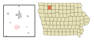
Gillett Grove is a city in Clay County, Iowa, United States. The population was 30 in the 2020 census, a decline from 55 in 2000.

<span class="mw-page-title-main">Peterson, Iowa</span> City in Iowa, United States

Peterson is a city in Clay County, Iowa, United States. The population was 322 in the 2020 census, a decline from 372 in 2000.

<span class="mw-page-title-main">Rossie, Iowa</span> City in Iowa, United States

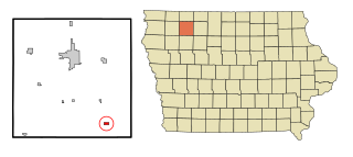
Rossie is a city in Clay County, Iowa, United States. The population was 49 in the 2020 census, a decrease from 58 in 2000.

<span class="mw-page-title-main">Royal, Iowa</span> City in Iowa, United States

Royal is a city in Clay County, Iowa, United States. The population was 379 in the 2020 census, a decline from 479 in 2000.

<span class="mw-page-title-main">Webb, Iowa</span> City in Iowa, United States

Webb is a city in Clay County, Iowa, United States. The population was 138 in the 2020 census, a decline from 165 in 2000.

<span class="mw-page-title-main">Buck Grove, Iowa</span> City in Iowa, United States

Buck Grove is a city in Crawford County, Iowa, United States. The population was 34 at the 2020 census.

<span class="mw-page-title-main">Pulaski, Iowa</span> City in Iowa, United States

Pulaski is a city in Davis County, Iowa, United States. The population was 264 at the time of the 2020 census.

<span class="mw-page-title-main">Maynard, Iowa</span> City in Iowa, United States

Maynard is a city in Fayette County, Iowa, United States. The population was 476 at the time of the 2020 census.

<span class="mw-page-title-main">Hayesville, Iowa</span> City in Iowa, United States

Hayesville is a city in Keokuk County, Iowa, United States. The population was 41 at the time of the 2020 census.

<span class="mw-page-title-main">Leighton, Iowa</span> City in Iowa, United States

Leighton is a city in Mahaska County, Iowa, United States. The population was 158 in the 2020 census, an increase from 153 in the 2000 census.

<span class="mw-page-title-main">Hancock, Iowa</span> City in Iowa, United States

Hancock is a city in Pottawattamie County, Iowa, United States, along the West Nishnabotna River. The population was 200 at the time of the 2020 census.

<span class="mw-page-title-main">Dixon, Iowa</span> City in Iowa, United States

Dixon is a city in Scott County, Iowa, United States. The population was 202 at the time of the 2020 census.

<span class="mw-page-title-main">Donahue, Iowa</span> City in Iowa, United States

Donahue is a city in Scott County, Iowa, United States. The population was 335 at the 2020 census. The city has a mayor-council form of government.

<span class="mw-page-title-main">Maysville, Iowa</span> City in Iowa, United States

Maysville is a city in Scott County, Iowa, United States. The population was 156 at the time of the 2020 census.

<span class="mw-page-title-main">Dickens, Texas</span> City in Texas, United States

Dickens is a city in and the county seat of Dickens County, Texas, United States. The population was 286 at the 2010 census, down from 332 at the 2000 census.

References

  1. "2020 U.S. Gazetteer Files". United States Census Bureau. Retrieved March 16, 2022.
  2. 1 2 "2020 Census State Redistricting Data". census.gov. United states Census Bureau. Retrieved August 12, 2021.
  3. Gillespie, Samuel (1909). History of Clay County, Iowa: From Its Earliest Settlement to 1909. S. J. Clarke Publishing Company. pp.  73.
  4. "US Gazetteer files: 2010, 2000, and 1990". United States Census Bureau. February 12, 2011. Retrieved April 23, 2011.
  5. "US Gazetteer files 2010". United States Census Bureau. Archived from the original on July 2, 2012. Retrieved May 11, 2012.
  6. "Census of Population and Housing". Census.gov. Retrieved June 4, 2015.
  7. "U.S. Census website". United States Census Bureau . Retrieved May 11, 2012.
  8. "U.S. Census website". United States Census Bureau . Retrieved January 31, 2008.
  9. "Spencer." Iowa Department of Education. Retrieved on July 21, 2018.
  10. Home. South Clay Community School District. November 4, 2001. Retrieved on July 20, 2018. "Welcome to South Clay Community School, a K-6 school serving the communities of Dickens, Gillett Grove, and Webb, Iowa."
  11. "REORGANIZATION & DISSOLUTION ACTIONS SINCE 1965-66 Archived 2018-06-19 at the Wayback Machine ." Iowa Department of Education. Retrieved on July 20, 2018.