Webb, Iowa

Last updated
Webb, Iowa
Clay County Iowa Incorporated and Unincorporated areas Webb Highlighted.svg
Location of Webb, Iowa
Coordinates: 42°56′53″N95°0′44″W / 42.94806°N 95.01222°W / 42.94806; -95.01222 Coordinates: 42°56′53″N95°0′44″W / 42.94806°N 95.01222°W / 42.94806; -95.01222
Country Flag of the United States.svg  United States
State Flag of Iowa.svg  Iowa
County Clay
Area
[1]
  Total0.50 sq mi (1.30 km2)
  Land0.50 sq mi (1.30 km2)
  Water0.00 sq mi (0.00 km2)
Elevation
1,375 ft (419 m)
Population
 (2020)
  Total138
  Density274.35/sq mi (105.87/km2)
Time zone UTC-6 (Central (CST))
  Summer (DST) UTC-5 (CDT)
ZIP code
51366
Area code 712
FIPS code 19-83010
GNIS feature ID0462768

Webb is a city in Clay County, Iowa, United States. The population was 138 in the 2020 census, a decline from 165 in 2000. [2]

Contents

Geography

Webb's longitude and latitude coordinates
in decimal form are 42.948134, -95.012281. [3]

According to the United States Census Bureau, the city has a total area of 0.50 square miles (1.29 km2), all land. [4]

Demographics

Historical population
CensusPop.
1910 150
1920 21946.0%
1930 2409.6%
1940 2545.8%
1950 235−7.5%
1960 2360.4%
1970 234−0.8%
1980 222−5.1%
1990 167−24.8%
2000 165−1.2%
2010 141−14.5%
2020 138−2.1%
U.S. Decennial Census [5] [2]

2010 census

As of the census [6] of 2010, there were 313 people, 63 households, and 40 families living in the city. The population density was 282.0 inhabitants per square mile (108.9/km2). There were 78 housing units at an average density of 156.0 per square mile (60.2/km2). The racial makeup of the city was 99.3% White and 0.7% African American.

There were 63 households, of which 23.8% had children under the age of 18 living with them, 52.4% were married couples living together, 3.2% had a female householder with no husband present, 7.9% had a male householder with no wife present, and 36.5% were non-families. 31.7% of all households were made up of individuals, and 15.9% had someone living alone who was 65 years of age or older. The average household size was 2.24 and the average family size was 2.83.

The median age in the city was 43.5 years. 22.7% of residents were under the age of 18; 6.5% were between the ages of 18 and 24; 22.8% were from 25 to 44; 26.2% were from 45 to 64; and 22% were 65 years of age or older. The gender makeup of the city was 52.5% male and 47.5% female.

2000 census

As of the census [7] of 2000, there were 165 people, 73 households, and 44 families living in the city. The population density was 328.0 inhabitants per square mile (126.6/km2). There were 83 housing units at an average density of 165.0 per square mile (63.7/km2). The racial makeup of the city was 99.39% White and 0.61% Native American. Hispanic or Latino of any race were 0.61% of the population.

There were 73 households, out of which 26.0% had children under the age of 18 living with them, 50.7% were married couples living together, 4.1% had a female householder with no husband present, and 38.4% were non-families. 34.2% of all households were made up of individuals, and 20.5% had someone living alone who was 65 years of age or older. The average household size was 2.26 and the average family size was 2.84.

In the city, the population was spread out, with 25.5% under the age of 18, 4.2% from 18 to 24, 24.2% from 25 to 44, 23.6% from 45 to 64, and 22.4% who were 65 years of age or older. The median age was 42 years. For every 100 females, there were 96.4 males. For every 100 females age 18 and over, there were 86.4 males.

The median income for a household in the city was $27,500, and the median income for a family was $31,500. Males had a median income of $30,000 versus $21,528 for females. The per capita income for the city was $13,087. About 10.4% of families and 9.8% of the population were below the poverty line, including 18.8% of those under the age of eighteen and none of those 65 or over.

Education

Sioux Central Community School District serves the community. [8]

Webb was previously a part of the South Clay Community School District; [9] on July 1, 2010, the district was dissolved, with portions going to Sioux Central. [10]

Related Research Articles

<span class="mw-page-title-main">Clay County, Iowa</span> County in Iowa, United States

Clay County is a county located in the U.S. state of Iowa. As of the 2020 census, the population was 16,384. Its county seat is Spencer. Its name is in honor of Henry Clay Jr., a colonel who died in action in the Mexican–American War, and son of Henry Clay, famous American statesman from Kentucky.

<span class="mw-page-title-main">Linn Grove, Iowa</span> City in Iowa, United States

Linn Grove is a city in Buena Vista County, Iowa, United States. The population was 163 at the time of the 2020 census. The nearby Chan-Ya-Ta Site contains the remains of a 1000-year-old prehistoric village, and is on the National Register of Historic Places.

<span class="mw-page-title-main">Newell, Iowa</span> City in Iowa, United States

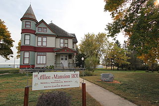
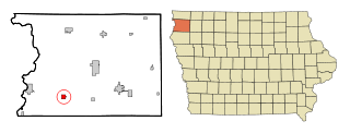
Newell is a city in Buena Vista County, Iowa, United States. The population was 906 according to the 2020 census.

<span class="mw-page-title-main">Rembrandt, Iowa</span> City in Iowa, United States

Rembrandt is a city in Buena Vista County, Iowa, United States. The population was 209 at the time of the 2020 census.

<span class="mw-page-title-main">Sioux Rapids, Iowa</span> City in Iowa, United States

Sioux Rapids is a city in Buena Vista County, Iowa, United States. The population was 748 at the time of the 2020 census.

<span class="mw-page-title-main">Dickens, Iowa</span> City in Iowa, United States

Dickens is a city in Clay County, Iowa, United States. The population was 146 in the 2020 census, a decline from 202 in 2000.

<span class="mw-page-title-main">Everly, Iowa</span> City in Iowa, United States

Everly is a city in Clay County, Iowa, United States. The population was 575 in the 2020 census, a decline from 647 in 2000. The Ocheyedan River flows to the south and west of the city. Famous people born here include Vern Fear.

<span class="mw-page-title-main">Gillett Grove, Iowa</span> City in Iowa, United States

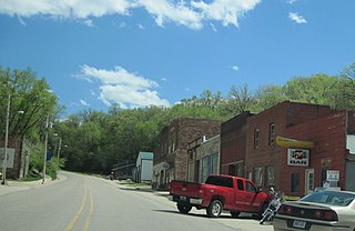
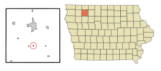
Gillett Grove is a city in Clay County, Iowa, United States. The population was 30 in the 2020 census, a decline from 55 in 2000.

<span class="mw-page-title-main">Greenville, Iowa</span> City in Iowa, United States

Greenville is a city in Clay County, Iowa, United States. The population was 71 in the 2020 census, a decline from 93 in 2000.

<span class="mw-page-title-main">Peterson, Iowa</span> City in Iowa, United States

Peterson is a city in Clay County, Iowa, United States. The population was 322 in the 2020 census, a decline from 372 in 2000.

<span class="mw-page-title-main">Royal, Iowa</span> City in Iowa, United States

Royal is a city in Clay County, Iowa, United States. The population was 379 in the 2020 census, a decline from 479 in 2000.

<span class="mw-page-title-main">Little Sioux, Iowa</span> City in Iowa, United States

Little Sioux is a city in Harrison County, Iowa, United States. The population was 166 at the time of the 2020 census. The city is most known for Little Sioux Scout Ranch of the Boy Scouts of America.

<span class="mw-page-title-main">Moorhead, Iowa</span> City in Iowa, United States

Moorhead is a city in Monona County, Iowa, United States. Moorhead stands along the Soldier River. The population was 199 at the time of the 2020 census.

<span class="mw-page-title-main">Onawa, Iowa</span> City in Iowa, USA

Onawa is a city in, and the county seat of, Monona County, Iowa, United States. The population was 2,906 at the time of the 2020 Census. It is the largest town on the Iowa side of the Missouri River between Council Bluffs and Sioux City.

<span class="mw-page-title-main">Chatsworth, Iowa</span> City in Iowa, United States

Chatsworth is a city in Sioux County, Iowa, United States. The population was 75 at the 2020 census.

<span class="mw-page-title-main">Ireton, Iowa</span> City in Iowa, United States

Ireton is a city in Sioux County, Iowa, United States. The population was 590 at the time of the 2020 census.

<span class="mw-page-title-main">Correctionville, Iowa</span> City in Iowa, United States

Correctionville is a city in Woodbury County, Iowa, United States. It is part of the Sioux City, IA–NE–SD Metropolitan Statistical Area. The population was 766 at the time of the 2020 census. The town name comes from the original survey of the town. Correctionville has been noted for its unusual place name. It is supposedly the longest single-word place name in the state of Iowa.

<span class="mw-page-title-main">Lawton, Iowa</span> City in Iowa, United States

Lawton is a city in Woodbury County, Iowa, Iowa, United States. It is part of the Sioux City metropolitan area. The population was 943 at the time of the 2020 census.

<span class="mw-page-title-main">Oto, Iowa</span> City in Iowa, United States

Oto is a city in Woodbury County, Iowa, United States. It is part of the Sioux City, IA–NE–SD Metropolitan Statistical Area. The population was 72 at the time of the 2020 census.

<span class="mw-page-title-main">Irene, South Dakota</span> City in South Dakota, United States

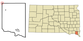
Irene is a city in Clay, Turner, and Yankton counties in South Dakota, United States. The population was 422 at the 2020 census. The portion of Irene that is located in Turner County is a part of the Sioux Falls, South Dakota metropolitan area, the portion located in Yankton County is part of the Yankton Micropolitan Statistical Area, and the portion located in Clay County is part of both the Vermillion Micropolitan Statistical Area and the Sioux City-Vermillion Combined Statistical Area. Irene is also host to the Irene Rodeo, held every summer.

References

  1. "2020 U.S. Gazetteer Files". United States Census Bureau. Retrieved March 16, 2022.
  2. 1 2 "2020 Census State Redistricting Data". census.gov. United states Census Bureau. Retrieved 12 August 2021.
  3. "US Gazetteer files: 2010, 2000, and 1990". United States Census Bureau. 2011-02-12. Retrieved 2011-04-23.
  4. "US Gazetteer files 2010". United States Census Bureau . Retrieved 2012-05-11.
  5. "Census of Population and Housing". Census.gov. Retrieved June 4, 2015.
  6. "U.S. Census website". United States Census Bureau . Retrieved 2012-05-11.
  7. "U.S. Census website". United States Census Bureau . Retrieved 2008-01-31.
  8. "Sioux Central." Iowa Department of Education. Retrieved on July 21, 2018.
  9. Home. South Clay Community School District. November 4, 2001. Retrieved on July 20, 2018. "Welcome to South Clay Community School, a K-6 school serving the communities of Dickens, Gillett Grove, and Webb, Iowa."
  10. "REORGANIZATION & DISSOLUTION ACTIONS SINCE 1965-66." Iowa Department of Education. Retrieved on July 20, 2018.

http://cityofwebb.com/