Greenville, Iowa

Last updated
Greenville, Iowa
Clay County Iowa Incorporated and Unincorporated areas Greenville Highlighted.svg
Coordinates: 43°0′58″N95°8′44″W / 43.01611°N 95.14556°W / 43.01611; -95.14556 Coordinates: 43°0′58″N95°8′44″W / 43.01611°N 95.14556°W / 43.01611; -95.14556
Country Flag of the United States.svg  United States
State Flag of Iowa.svg  Iowa
County Clay
Area
[1]
  Total0.17 sq mi (0.43 km2)
  Land0.17 sq mi (0.43 km2)
  Water0.00 sq mi (0.00 km2)
Elevation
1,391 ft (424 m)
Population
 (2020)
  Total71
  Density427.71/sq mi (165.34/km2)
Time zone UTC-6 (Central (CST))
  Summer (DST) UTC-5 (CDT)
ZIP code
51343
Area code(s) 712
FIPS code 19-32970
GNIS feature ID0465587

Greenville is a city in Clay County, Iowa, United States. The population was 71 in the 2020 census, a decline from 93 in 2000. [2]

Contents

History

The Greenville post office opened in 1871. The town was named for its first postmaster, A. W. Green. [3]

Bank robbery of 1901

On November 16, 1901, one Mr. Brown opened the bank in Greenville and discovered that the bank had been robbed. The vault handle had been removed, explosives placed into the opening, and the vault door blown off.

Three men were seen later in Spencer, then Webb, and finally Albert City where they were cornered at the depot. A gunfight ensued, during which one of the gunmen was killed. The other two were captured and later sentenced to life terms in Fort Madison, while the dead gunman was buried in an unnamed grave in Fairfield Cemetery in Albert City.

Sixty-four empty shells were picked up in the depot after the fight. [4]

Geography

Greenville is located at 43°0′58″N95°8′44″W / 43.01611°N 95.14556°W / 43.01611; -95.14556 (43.016091, -95.145464). [5]

According to the United States Census Bureau, the city has a total area of 0.18 square miles (0.47 km2), all land. [6]

Demographics

Historical population
CensusPop.
1920 167
1930 1680.6%
1940 1690.6%
1950 1732.4%
1960 1730.0%
1970 117−32.4%
1980 1224.3%
1990 84−31.1%
2000 9310.7%
2010 75−19.4%
2020 71−5.3%
U.S. Decennial Census [7] [2]
The population of Greenville, Iowa from US census data GreenvilleIowaPopPlot.png
The population of Greenville, Iowa from US census data

2010 census

As of the census [8] of 2010, there were 75 people, 30 households, and 18 families residing in the city. The population density was 416.7 inhabitants per square mile (160.9/km2). There were 34 housing units at an average density of 188.9 per square mile (72.9/km2). The racial makeup of the city was 96.0% White and 4.0% Native American. Hispanic or Latino of any race were 2.7% of the population.

There were 30 households, of which 30.0% had children under the age of 18 living with them, 56.7% were married couples living together, 3.3% had a female householder with no husband present, and 40.0% were non-families. 30.0% of all households were made up of individuals, and 16.7% had someone living alone who was 65 years of age or older. The average household size was 2.50 and the average family size was 3.17.

The median age in the city was 36.8 years. 24% of residents were under the age of 18; 9.3% were between the ages of 18 and 24; 26.6% were from 25 to 44; 29.3% were from 45 to 64; and 10.7% were 65 years of age or older. The gender makeup of the city was 49.3% male and 50.7% female.

2000 census

As of the census [9] of 2000, there were 93 people, 34 households, and 24 families residing in the city. The population density was

There were 34 households, out of which 38.2% had children under the age of 18 living with them, 70.6% were married couples living together, 2.9% had a female householder with no husband present, and 26.5% were non-families. 23.5% of all households were made up of individuals, and 11.8% had someone living alone who was 65 years of age or older. The average household size was 2.74 and the average family size was 3.20.

In the city, the population was spread out, with 31.2% under the age of 18, 5.4% from 18 to 24, 26.9% from 25 to 44, 26.9% from 45 to 64, and 9.7% who were 65 years of age or older. The median age was 38 years. For every 100 females, there were 102.2 males. For every 100 females age 18 and over, there were 93.9 males.

The median income for a household in the city was $29,531, and the median income for a family was $37,500. Males had a median income of $34,063 versus $21,250 for females. The per capita income for the city was $22,217. There were 18.8% of families and 19.2% of the population living below the poverty line, including 23.8% of under eighteens and none of those over 64.

Notable people

Education

Clay Central–Everly Community School District operates public schools serving the community. [12]

Related Research Articles

Clay County, Iowa County in Iowa, United States

Clay County is a county located in the U.S. state of Iowa. As of the 2020 census, the population was 16,384. Its county seat is Spencer. Its name is in honor of Henry Clay, Jr., a colonel who died in action in the Mexican–American War, and son of Henry Clay, famous American statesman from Kentucky.

Farm Loop, Alaska CDP in Alaska, United States

Farm Loop is a census-designated place (CDP) in Matanuska-Susitna Borough, Alaska, United States. It is part of the Anchorage, Alaska Metropolitan Statistical Area. At the 2020 census the population was 2,747, up from 1,028 in 2010.

Franklin, Idaho City in Idaho, United States

Franklin is a city in Franklin County, Idaho, United States. The population was 641 at the 2010 census. It is part of the Logan, Utah-Idaho Metropolitan Statistical Area.

Fruitland, Idaho City in Idaho, United States

Fruitland is a city in Payette County, Idaho, United States. It lies along U.S. Route 95 in the Treasure Valley of southwest Idaho, about 50 miles (80 km) west of Boise on the border with Oregon. It is part of the Ontario Micropolitan Area. Fruitland is named after apple orchards that surround the community, and its slogan is "The Big Apple of Idaho."

Dickens, Iowa City in Iowa, United States

Dickens is a city in Clay County, Iowa, United States. The population was 146 in the 2020 census, a decline from 202 in 2000.

Everly, Iowa City in Iowa, United States

Everly is a city in Clay County, Iowa, United States. The population was 575 in the 2020 census, a decline from 647 in 2000. The Ocheyedan River flows to the south and west of the city. Famous people born here include Vern Fear.

Fostoria, Iowa City in Iowa, United States

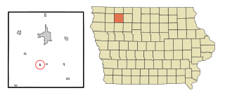
Fostoria is a city in Clay County, Iowa, United States. The population was 230 in the 2020 census, unchanged from the 2000.

Gillett Grove, Iowa City in Iowa, United States

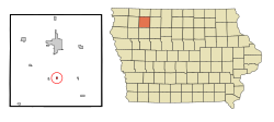
Gillett Grove is a city in Clay County, Iowa, United States. The population was 30 in the 2020 census, a decline from 55 in 2000.

Peterson, Iowa City in Iowa, United States

Peterson is a city in Clay County, Iowa, United States. The population was 322 in the 2020 census, a decline from 372 in 2000.

Rossie, Iowa City in Iowa, United States

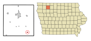
Rossie is a city in Clay County, Iowa, United States. The population was 49 in the 2020 census, a decrease from 58 in 2000.

Royal, Iowa City in Iowa, United States

Royal is a city in Clay County, Iowa, United States. The population was 379 in the 2020 census, a decline from 479 in 2000.

Webb, Iowa City in Iowa, United States

Webb is a city in Clay County, Iowa, United States. The population was 138 in the 2020 census, a decline from 165 in 2000.

Fayette, Missouri City in Missouri, United States

Fayette is a city in and the county seat of Howard County, Missouri, United States. It is part of the Columbia, Missouri Metropolitan Statistical Area. The city's population was 2,803 at the 2020 census.

Arbela, Missouri Village in Missouri, United States

Arbela is a village in Scotland County, Missouri, United States. As of the 2020 census, its population was 24.

Gilead, Nebraska Village in Nebraska, United States

Gilead is a village in Thayer County, Nebraska, United States. The population was 39 at the 2010 census.

New Franklin, Missouri City in Missouri, United States

New Franklin is a city in Howard County, Missouri, United States. The population was 1,027 at the 2020 census. It is part of the Columbia, Missouri Metropolitan Statistical Area.

Dayton Lakes, Texas City in Texas, United States

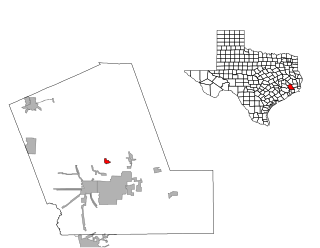
Dayton Lakes is a city in Liberty County, Texas, United States. The population was 93 at the 2010 census. Prior to 1985 Dayton Lakes city was a developed and marketed recreational subdivision named Dayton Lake Estates. In January 1985 the corporation that marketed the original subdivision held and election of residents and when the election was successful, they petitioned the District Court in Liberty County, Texas and The City of Dayton Lakes, TX, a Non Profit Corporation, was created as a city/town. The actual document was filed and recorded on January 19, 1985. Those corporate papers are the city's legal identity.

Lac La Belle, Wisconsin Village in Wisconsin, United States

Lac La Belle is a village located mostly in Waukesha County in the U.S. state of Wisconsin. The population was 290 at the 2010 census. Of this, 289 were in Waukesha County, and one person was in Jefferson County. The village is located mostly within the town of Oconomowoc in Waukesha County. On March 28, 2002, the village annexed a portion of land in the town of Ixonia in Jefferson County.

Etna, Wyoming Census-designated place in Wyoming, United States

Etna is a census-designated place (CDP) in Lincoln County, Wyoming, United States. The population was 164 at the 2010 census.

Milford (CDP), Massachusetts CDP in Massachusetts, United States

Milford is a census-designated place (CDP) in the town of Milford in Worcester County, Massachusetts, United States. The population was 25,055 at the 2010 census.

References

  1. "2020 U.S. Gazetteer Files". United States Census Bureau. Retrieved March 16, 2022.
  2. 1 2 "2020 Census State Redistricting Data". census.gov. United states Census Bureau. Retrieved 12 August 2021.
  3. Gillespie, Samuel (1909). History of Clay County, Iowa: From Its Earliest Settlement to 1909. S. J. Clarke Publishing Company. pp.  62.
  4. History of Albert City
  5. "US Gazetteer files: 2010, 2000, and 1990". United States Census Bureau. 2011-02-12. Retrieved 2011-04-23.
  6. "US Gazetteer files 2010". United States Census Bureau. Archived from the original on 2012-01-25. Retrieved 2012-05-11.
  7. "Census of Population and Housing". Census.gov. Retrieved June 4, 2015.
  8. "U.S. Census website". United States Census Bureau . Retrieved 2012-05-11.
  9. "U.S. Census website". United States Census Bureau . Retrieved 2008-01-31.
  10. Medal of Honor Database
  11. Arlington National Cemetery Database
  12. "Clay Central-Everly." Iowa Department of Education. Retrieved on July 21, 2018.