Fostoria, Iowa

Last updated

Fostoria, Iowa
Clay County Iowa Incorporated and Unincorporated areas Fostoria Highlighted.svg
Location of Fostoria, Iowa
Coordinates: 43°14′30″N95°9′18″W / 43.24167°N 95.15500°W / 43.24167; -95.15500
Country Flag of the United States (23px).png  United States
State Flag of Iowa.svg  Iowa
County Clay
Area
[1]
  Total0.41 sq mi (1.05 km2)
  Land0.41 sq mi (1.05 km2)
  Water0.00 sq mi (0.00 km2)
Elevation
1,457 ft (444 m)
Population
 (2020)
  Total230
  Density566.50/sq mi (218.61/km2)
Time zone UTC-6 (Central (CST))
  Summer (DST) UTC-5 (CDT)
ZIP code
51340
Area code 712
FIPS code 19-28650
GNIS feature ID0456695

Fostoria is a city in Clay County, Iowa, United States. The population was 230 in the 2020 census, unchanged from the 2000. [2]

Contents

Geography

Fostoria's longitude and latitude coordinates
in decimal form are 43.241539, -95.155039. [3]

According to the United States Census Bureau, the city has a total area of 0.47 square miles (1.22 km2), all land. [4]

Demographics

Historical population
CensusPop.Note
1920 119
1930 14219.3%
1940 136−4.2%
1950 1478.1%
1960 16713.6%
1970 21931.1%
1980 26119.2%
1990 205−21.5%
2000 23012.2%
2010 2310.4%
2020 230−0.4%
U.S. Decennial Census [5] [2]
The population of Fostoria, Iowa from US census data FostoriaIowaPopPlot.png
The population of Fostoria, Iowa from US census data

2010 census

As of the census [6] of 2010, there were 231 people, 87 households, and 63 families residing in the city. The population density was 491.5 inhabitants per square mile (189.8/km2). There were 94 housing units at an average density of 200.0 per square mile (77.2/km2). The racial makeup of the city was 96.5% White, 0.4% Asian, 0.9% from other races, and 2.2% from two or more races. Hispanic or Latino of any race were 2.6% of the population.

There were 87 households, of which 36.8% had children under the age of 18 living with them, 57.5% were married couples living together, 8.0% had a female householder with no husband present, 6.9% had a male householder with no wife present, and 27.6% were non-families. 20.7% of all households were made up of individuals, and 6.9% had someone living alone who was 65 years of age or older. The average household size was 2.66 and the average family size was 3.14.

The median age in the city was 39.3 years. 28.6% of residents were under the age of 18; 3% were between the ages of 18 and 24; 27.8% were from 25 to 44; 30.8% were from 45 to 64; and 10% were 65 years of age or older. The gender makeup of the city was 51.1% male and 48.9% female.

2000 census

As of the census [7] of 2000, there were 230 people, 95 households, and 70 families residing in the city. The population density was 483.7 inhabitants per square mile (186.8/km2). There were 97 housing units at an average density of 204.0 per square mile (78.8/km2). The racial makeup of the city was 96.96% White, 0.43% African American, 0.87% Asian, 0.43% from other races, and 1.30% from two or more races. Hispanic or Latino of any race were 0.87% of the population.

There were 95 households, out of which 36.8% had children under the age of 18 living with them, 60.0% were married couples living together, 9.5% had a female householder with no husband present, and 26.3% were non-families. 20.0% of all households were made up of individuals, and 6.3% had someone living alone who was 65 years of age or older. The average household size was 2.42 and the average family size was 2.77.

In the city, the population was spread out, with 26.5% under the age of 18, 2.6% from 18 to 24, 36.1% from 25 to 44, 22.6% from 45 to 64, and 12.2% who were 65 years of age or older. The median age was 37 years. For every 100 females, there were 100.0 males. For every 100 females age 18 and over, there were 92.0 males.

The median income for a household in the city was $38,750, and the median income for a family was $42,250. Males had a median income of $30,313 versus $20,125 for females. The per capita income for the city was $15,952. None of the families and 2.2% of the population were living below the poverty line, including no under eighteens and 12.0% of those over 64.

Education

Most of the community is served by the Okoboji Community School District. [8] The district was established on July 1, 1988 by the merger of the Arnolds Park and Milford school districts. [9] Okoboji High School in Milford is the local high school.

A small part of Fostoria is within the Spencer Community School District. [10]

Related Research Articles

<span class="mw-page-title-main">Dickinson County, Iowa</span> County in Iowa, United States

Dickinson County is a county located in the U.S. state of Iowa. As of the 2020 census, the population was 17,703. The county seat is Spirit Lake. The county was organized in 1857 and is named in honor of Daniel S. Dickinson, a U.S. Senator for New York.

<span class="mw-page-title-main">Moulton, Iowa</span> City in Iowa, United States

Moulton is a city in Appanoose County, Iowa, United States. The population was 607 at the time of the 2020 census.

<span class="mw-page-title-main">Fairbank, Iowa</span> City in Iowa, United States

Fairbank is a city in Buchanan and Fayette counties in the U.S. state of Iowa. The population was 1,111 at the time of the 2020 census.

<span class="mw-page-title-main">Arnolds Park, Iowa</span> City in Iowa, United States

Arnolds Park is a city in Dickinson County, Iowa, United States. The population was 1,110 in the 2020 census, a decline from the 1,162 population in the 2000 census.

<span class="mw-page-title-main">Milford, Iowa</span> City in Iowa, United States

Milford is a city in Dickinson County, Iowa, United States. The population was 3,321 at the time of the 2020 census. The town includes many businesses related to its location in the Iowa Great Lakes region and is often referred to as the southern gateway to the Iowa Great Lakes.

<span class="mw-page-title-main">Okoboji, Iowa</span> City in Iowa, United States

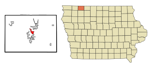
Okoboji is a city in Dickinson County, Iowa, United States, along the eastern shore of West Okoboji Lake in the Iowa Great Lakes region. At the time of the 2020 census, its population was 768.

<span class="mw-page-title-main">Spirit Lake, Iowa</span> City in Iowa, United States

Spirit Lake is a city in Dickinson County, Iowa, United States. The population was 5,439 at the 2020 census. It is the county seat of Dickinson County.

<span class="mw-page-title-main">Wahpeton, Iowa</span> City in Iowa, United States

Wahpeton is a city in Dickinson County, Iowa, United States. The population was 345 at the time of the 2020 census.

<span class="mw-page-title-main">West Okoboji, Iowa</span> City in Iowa, United States

West Okoboji is a city in Dickinson County, Iowa, United States. The population was 308 at the time of the 2020 census. The city is located on West Okoboji Lake, from which it takes its name. It is part of the Iowa Great Lakes region.

<span class="mw-page-title-main">Mondamin, Iowa</span> City in Iowa, United States

Mondamin is a city in Harrison County, Iowa, United States. The population was 339 at the time of the 2020 census.

<span class="mw-page-title-main">Woodbine, Iowa</span> City in Iowa, United States

Woodbine is a city in Harrison County, Iowa, United States, along the Boyer River. The population was 1,625 at the time of the 2020 census.

<span class="mw-page-title-main">Hills, Iowa</span> City in Iowa, United States

Hills is a city in Johnson County, Iowa, United States. It is part of the Iowa City, Iowa Metropolitan Statistical Area. The population was 863 at the time of the 2020 census. It is part of the Iowa City Community School District.

<span class="mw-page-title-main">Wapello, Iowa</span> City in Iowa, United States

Wapello is a city in and the county seat of Louisa County, Iowa, United States. The population was 2,084 at the time of the 2020 census.

<span class="mw-page-title-main">Leighton, Iowa</span> City in Iowa, United States

Leighton is a city in Mahaska County, Iowa, United States. The population was 158 in the 2020 census, an increase from 153 in the 2000 census.

<span class="mw-page-title-main">Emerson, Iowa</span> City in Iowa, United States

Emerson is a city in Mills County, Iowa, United States. The population was 403 at the time of the 2020 census.

<span class="mw-page-title-main">Runnells, Iowa</span> City in Iowa, United States

Runnells is a city in the southeastern corner of Polk County, Iowa, United States. The population was 457 at the time of the 2020 census. It is part of the Des Moines–West Des Moines Metropolitan Statistical Area. Runnells has its own Post Office, located at 112 Brown Street.

<span class="mw-page-title-main">McClelland, Iowa</span> City in Iowa, United States

McClelland is a city in Pottawattamie County, Iowa, United States. The city was founded in 1903 after the Great Western Railroad was extended to include Council Bluffs, Iowa The population was 146 at the time of the 2020 census.

<span class="mw-page-title-main">Dixon, Iowa</span> City in Iowa, United States

Dixon is a city in Scott County, Iowa, United States. The population was 202 at the time of the 2020 census.

<span class="mw-page-title-main">Cambridge, Iowa</span> City in Iowa, United States

Cambridge is a city in Story County, Iowa, United States. The population was 827 at the 2020 census. It is part of the Ames, Iowa Metropolitan Statistical Area, which is a part of the larger Ames-Boone, Iowa Combined Statistical Area.

<span class="mw-page-title-main">Fostoria, Ohio</span> City in Ohio, United States

Fostoria is a city located at the convergence of Hancock, Seneca, and Wood counties in the northwestern part of the U.S. state of Ohio. The population was 13,046 at the 2020 Census, slightly down from 13,441 at the 2010 Census. It is approximately 40 miles (64 km) south of Toledo and 90 miles (140 km) north of Columbus. The community grew substantially during the end of the 19th century, coinciding with the northwest Ohio gas boom. Typical of Rust Belt cities, Fostoria peaked in size in 1970.

References

  1. "2020 U.S. Gazetteer Files". United States Census Bureau. Retrieved March 16, 2022.
  2. 1 2 "2020 Census State Redistricting Data". census.gov. United states Census Bureau. Retrieved August 12, 2021.
  3. "US Gazetteer files: 2010, 2000, and 1990". United States Census Bureau. February 12, 2011. Retrieved April 23, 2011.
  4. "US Gazetteer files 2010". United States Census Bureau. Archived from the original on July 2, 2012. Retrieved May 11, 2012.
  5. "Census of Population and Housing". Census.gov. Retrieved June 4, 2015.
  6. "U.S. Census website". United States Census Bureau . Retrieved May 11, 2012.
  7. "U.S. Census website". United States Census Bureau . Retrieved January 31, 2008.
  8. "Okoboji" (PDF). Iowa Department of Education . Retrieved March 24, 2020.
  9. "REORGANIZATION & DISSOLUTION ACTIONS SINCE 1965-66" (PDF). Iowa Department of Education. Archived from the original (PDF) on February 9, 2019. Retrieved March 22, 2020.
  10. "Spencer." Iowa Department of Education. Retrieved on July 21, 2018.