Environmental impact of reservoirs

Last updated
The Wachusett Dam in Clinton, Massachusetts. Wachusett-dam.jpg
The Wachusett Dam in Clinton, Massachusetts.

The environmental impact of reservoirs comes under ever-increasing scrutiny as the global demand for water and energy increases and the number and size of reservoirs increases.

Contents

Dams and reservoirs can be used to supply drinking water, generate hydroelectric power, increase the water supply for irrigation, provide recreational opportunities, and flood control. In 1960 the construction of Llyn Celyn and the flooding of Capel Celyn provoked political uproar which continues to this day. More recently, the construction of Three Gorges Dam and other similar projects throughout Asia, Africa and Latin America have generated considerable environmental and political debate. Currently, 48 percent of rivers and their hydro-ecological systems are affected by reservoirs and dams. [1]

Upstream impacts

Lake Nasser behind the Aswan dam, Egypt, 5250 km , displaced 60,000 people Lake Nasser.jpg
Lake Nasser behind the Aswan dam, Egypt, 5250 km , displaced 60,000 people

Fragmentation of river ecosystems

A dam acts as a barrier between the upstream and downstream movement of migratory river animals, such as salmon and trout. [3]

Some communities have also begun the practice of transporting migratory fish upstream to spawn via a barge. [3]

Reservoir sedimentation

Rivers carry sediment down their riverbeds, allowing for the formation of depositional features such as river deltas, alluvial fans, braided rivers, oxbow lakes, levees and coastal shores. The construction of a dam blocks the flow of sediment downstream, leading to downstream erosion of these sedimentary depositional environments, and increased sediment build-up in the reservoir. While the rate of sedimentation varies for each dam and each river, eventually all reservoirs develop a reduced water-storage capacity due to the exchange of "live storage" space for sediment. [4] Diminished storage capacity results in decreased ability to produce hydroelectric power, reduced availability of water for irrigation, and if left unaddressed, may ultimately result in the expiration of the dam and river. [5]

The trapping of sediment in reservoirs reduce sediment delivery downstream, which negatively impacts channel morphology, aquatic habitats and land elevation maintenance of deltas. [6] Apart from dam removal, there are other strategies to mitigate reservoir sedimentation.

Flushing flow method

The flushing flow method involves partially or completely emptying the reservoir behind a dam to erode the sediment stored on the bottom and transport it downstream. [7] [6] Flushing flows aim to restore natural water and sediment fluxes in the river downstream of the dam, however the flushing flow method is less costly compared to removing dams or constructing bypass tunnels.

Flushing flows have been implemented in the Ebro river twice a year in autumn and spring since 2003, except for two dry years in 2004 and 2005. [8] [9] The construction of multiple dams on the Ebro river disrupted the delivery of sediments downstream and as a result, the Ebro delta faces a sediment deficit. The river channel also narrowed and bank erosion increased. [7] During experiments, it was found that suspended sediment concentration during flushing flows is double that of natural floods, although the total water discharge is lower. This means that flushing flows have a relatively high sediment transport capacity, [8] which in turn suggests that flushing flows positively impact downstream river ecosystems, maximising sediment delivery to the lowest reaches of the river. [10] A total of 340,000 t/year of sediment could be delivered to the Ebro delta, which could result in a net accretion rate of 1 mm per year. [7]

Sediment bypasses

Sediment bypass tunnels can partially restore sediment dynamics in rivers downstream of dams, and are primarily used in Japan and Switzerland. [11] Bypass tunnels divert part of the incoming water and sediments during floods into a tunnel around a reservoir and dam. The water and sediment thus never enter the reservoir but join the river again below the dam. [12] Bypass tunnels reduce riverbed erosion and increase morphological variability below the dam. [13]

Impact below dam

River line and coastal erosion

As all dams result in reduced sediment load downstream, a dammed river is greatly demanding for sediment as it will not have enough sediment. This is because the rate of deposition of sediment is greatly reduced since there is less to deposit but the rate of erosion remains nearly constant, the water flow erodes the river shores and riverbed, threatening shoreline ecosystems, deepening the riverbed, and narrowing the river over time. This leads to a compromised water table, reduced water levels, homogenization of the river flow and thus reduced ecosystem variability, reduced support for wildlife, and reduced amount of sediment reaching coastal plains and deltas. [5] This prompts coastal erosion, as beaches are unable to replenish what waves erode without the sediment deposition of supporting river systems. [14] Downstream channel erosion of dammed rivers is related to the morphology of the riverbed, which is different from directly studying the amounts of sedimentation because it is subject to specific long term conditions for each river system. For example, the eroded channel could create a lower water table level in the affected area, impacting bottomland crops such as alfalfa or corn, and resulting in a smaller supply. [15] In the case of the Three Gorges Dam in China the changes described above now appears to have arrived at a new balance of erosion and sedimentation over a 10-year period in the lower reaches of the river. The impacts on the tidal region have also been linked to the upstream effects of the dam. [16]

In addition to coastal erosion impacts, reduced river flow may also alter ocean currents and ecosystems. [17]

Nutrients sequestration

Once a dam is put in place represents an obstacle to the flux of nutrients such as carbon (C), nitrogen (N), phosphorus (P), and silicon (Si) on downstream river, floodplains and delta. The increased residence time of these elements in the lentic system of a reservoir, compared to the lotic system of a river, promotes their sedimentation or elimination  [18] which can be up to 40%, 50%, and 60% for nitrogen, phosphorus and silica respectively [19] and this ultimately changes nutrients stoichiometry in the aquatic ecosystem downstream a dam.  The stochiometric imbalance of nitrogen, phosphorus, and silicon of the outflow can have repercussion on downstream ecosystems by shifting the phytoplankton community at the base of the food web with consequences to the whole aquatic population. [20] [21] [22] An example is the effect of the construction of the Aswan High dam in Egypt, where the drop in nutrient concentration to the Nile delta impeded the diatom blooms causing a substantial decrease the fish population of Sardinella aurita and Sardinella eba, while the reduced load of mud and silt affected the micro-benthic fauna leading to the decline of shrimp population. [23] The change in nutrients stoichiometry and silicon depletion at a river delta can also cause harmful algal and bacterial blooms to the detriment of diatoms' growth for whom silicon availability represents a milestone for shells' formation.

Since dammed rivers store nutrients during their lifespan, it can be expected that when a dam is removed, these legacy nutrients are remobilized causing downstream ecosystems' eutrophication and probable loss of biodiversity, thereby achieving the opposite effect desired by the river restoration action at dam dismissal.

Water temperature

The water of a deep reservoir in temperate climates typically stratifies with a large volume of cold, oxygen poor water in the hypolimnion. Analysis of temperature profiles from 11 large dams in the Murray Darling Basin (Australia) indicated differences between surface water and bottom water temperatures up to 16.7 degrees Celsius. [24] If this water is released to maintain river flow, it can cause adverse impacts on the downstream ecosystem including fish populations. [25] Under worse case conditions (such as when the reservoir is full or near full), the stored water is strongly stratified and large volumes of water are being released to the downstream river channel via bottom level outlets, depressed temperatures can be detected 250 - 350 kilometres downstream. [24] The operators of Burrendong Dam on the Macquarie River (eastern Australia) are attempting to address thermal suppression by hanging a geotextile curtain around the existing outlet tower to force the selective release of surface water. [26]

Natural ecosystems destroyed by agriculture

Many dams are built for irrigation and although there is an existing dry ecosystem downstream, it is deliberately destroyed in favor of irrigated farming. After the Aswan Dam was constructed in Egypt it protected Egypt from the droughts in 1972–73 and 1983–87 that devastated East and West Africa. The dam allowed Egypt to reclaim about 840,000 hectares in the Nile Delta and along the Nile Valley, increasing the country's irrigated area by a third. The increase was brought about both by irrigating what used to be desert and by bringing under cultivation 385,000 hectares that were natural flood retention basins. About half a million families were settled on these new lands. In 1983 the Franklin Dam project in Tasmania, Australia was cancelled following a campaign to protect surrounding forest from clearing and flooding. [27]

Effects on flood-dependent ecology and agriculture

In many[ quantify ] low lying developing countries[ example needed ] the savanna and forest ecology adjacent to floodplains and river deltas are irrigated by wet season annual floods. Farmers annually plant flood recession crops, where the land is cultivated after floods recede to take advantage of the moist soil. Dams generally discourage this cultivation and prevent annual flooding, creating a dryer downstream ecology while providing a constant water supply for irrigation.

Water becomes scarce for nomadic pastoralist in Baluchistan due to new dam developments for irrigation. BaluchNomads.jpg
Water becomes scarce for nomadic pastoralist in Baluchistan due to new dam developments for irrigation.

Case studies

Potential for disaster

Dams occasionally break causing catastrophic damage to communities downstream. Dams break due to engineering errors, attack or natural disaster. The greatest dam break disaster to date happened in China in 1975 killing 200,000 Chinese citizens. Other major failures during the 20th century were at Morbi, India (5,000 fatalities), at Vajont, Italy (2000 dead), while three other dam failures have each caused at least 1000 fatalities.

Flood control

The controversial Three Gorges Dam in China is able to store 22 cubic kilometres of floodwaters on the Yangtze River. The 1954 Yangtze River floods killed 33,000 people and displaced 18 million people from their homes. In 1998 a flood killed 4000 people and 180 million people were affected. The flooding of the reservoir caused over a million people to relocate, then a flood in August 2009 was completely captured by the new reservoir, protecting hundreds of millions of people downstream.

Mercury cycling and methylmercury production

The creation of reservoirs can alter the natural biogeochemical cycle of mercury. Studies conducted on the formation of an experimental reservoir by the flooding of a boreal wetland showed a 39-fold increase in the production of toxic methylmercury (MeHg) following the flooding. [31] The increase in MeHg production only lasted about 2–3 years before returning to near normal levels. However, MeHg concentration in lower food chain organisms remained high and showed no signs of returning to pre-flood levels. The fate of MeHg during this time period is important when considering its potential to bioaccumulate in predatory fish. [32]

Effects beyond the reservoir

Effects on humans

Diseases
Whilst reservoirs are helpful to humans, they can also be harmful as well. One negative effect is that the reservoirs can become breeding grounds for disease vectors. This holds true especially in tropical areas where mosquitoes (which are vectors for malaria) and snails (which are vectors for Schistosomiasis) can take advantage of this slow flowing water. [33]

Lake Manantali, 477 km , displaced 12,000 people. 10.34748W 13.10430N.png
Lake Manantali, 477 km , displaced 12,000 people.

Resettlement
Dams and the creation of reservoirs also require relocation of potentially large human populations if they are constructed close to residential areas. The record for the largest population relocated belongs to the Three Gorges dam built in China. Its reservoir submerged a large area of land, forcing over a million people to relocate. "Dam related relocation affects society in three ways: an economic disaster, human trauma, and social catastrophe", states Dr. Michael Cernea of the World Bank and Dr. Thayer Scudder, a professor at the California Institute of Technology. [2] As well, as resettlement of communities, care must also be taken not to irreparably damage sites of historical or cultural value. The Aswan Dam forced the movement of the Temple at Aswan to prevent its destruction by the flooding of the reservoir.

Greenhouse gases

Reservoirs may contribute to changes in the Earth's climate. Warm climate reservoirs generate methane, a greenhouse gas when the reservoirs are stratified, in which the bottom layers are anoxic (i.e. they lack oxygen), leading to degradation of biomass through anaerobic processes. [34] [ page needed ] At a dam in Brazil, where the flooded basin is wide and the biomass volume is high the methane produced results in a pollution potential 3.5 times more than an oil-fired power plant would be. [35] A theoretical study has indicated that globally hydroelectric reservoirs may emit 104 million metric tonnes of methane gas annually. [36] Methane gas is a significant contributor to global climate change. This isn't an isolated case, and it appears that especially hydroelectric dams constructed in lowland rainforest areas (where inundation of a part of the forest is necessary) produce large amounts of methane. Bruce Forsberg and Alexandre Kemenes have demonstrated that the Balbina Dam for instance emits 39,000 tonnes of methane each year [37] and three other dams in the Amazon produce at least 3 to 4× as much CO2 as an equivalent coal-fired power plant. Reasons for this being that lowland rainforests are extremely productive and thus stores far more carbon than other forests. Also, microbes that digest rotting material grow better in hot climates, thus producing more greenhouse gases. Despite this, as of 2020, another 150 hydroelectric dams are planned to be constructed in the Amazon basin. [38] There is some indication that greenhouse gas emissions decline over the lifetime of the dam. "But even including methane emissions, total GHG [Green-House Gas] per KWh generated from hydropower is still at least half that from the least polluting thermal alternatives.Thus, from the perspective of global warming mitigation, dams are the most attractive alternative to fossil fuel based energy sources." [34]

Research conducted at the Experimental Lakes Area indicates that creating reservoirs through the flooding of boreal wetlands, which are sinks for CO2, converts the wetlands into sources of atmospheric carbon. [31] In these ecosystems, variation in organic carbon content has been found to have little effect on the rates of greenhouse gas emission. This means that other factors such as the lability of carbon compounds and temperature of the flooded soil are important to consider. [39]

The following table indicates reservoir emissions in milligrams per square meter per day for different bodies of water. [40]

LocationCarbon DioxideMethane
Lakes7009
Temperate reservoirs150020
Tropical reservoirs3000100

See also

Related Research Articles

<span class="mw-page-title-main">Hydropower</span> Power generation via movement of water

Hydropower, also known as water power, is the use of falling or fast-running water to produce electricity or to power machines. This is achieved by converting the gravitational potential or kinetic energy of a water source to produce power. Hydropower is a method of sustainable energy production. Hydropower is now used principally for hydroelectric power generation, and is also applied as one half of an energy storage system known as pumped-storage hydroelectricity.

<span class="mw-page-title-main">Dam</span> Barrier that stops or restricts the flow of surface or underground streams

A dam is a barrier that stops or restricts the flow of surface water or underground streams. Reservoirs created by dams not only suppress floods but also provide water for activities such as irrigation, human consumption, industrial use, aquaculture, and navigability. Hydropower is often used in conjunction with dams to generate electricity. A dam can also be used to collect or store water which can be evenly distributed between locations. Dams generally serve the primary purpose of retaining water, while other structures such as floodgates or levees are used to manage or prevent water flow into specific land regions.

<span class="mw-page-title-main">Floodplain</span> Land adjacent to a river which is flooded during periods of high discharge

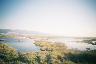
A floodplain or flood plain or bottomlands is an area of land adjacent to a river. Floodplains stretch from the banks of a river channel to the base of the enclosing valley, and experience flooding during periods of high discharge. The soils usually consist of clays, silts, sands, and gravels deposited during floods.

<span class="mw-page-title-main">River delta</span> Silt deposition landform at the mouth of a river

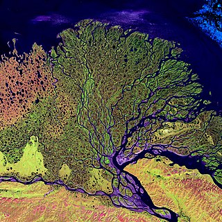
A river delta is a landform shaped like a triangle, created by the deposition of sediment that is carried by a river and enters slower-moving or stagnant water. This occurs when a river enters an ocean, sea, estuary, lake, reservoir, or another river that cannot carry away the supplied sediment. It is so named because its triangle shape resembles the Greek letter Delta. The size and shape of a delta are controlled by the balance between watershed processes that supply sediment, and receiving basin processes that redistribute, sequester, and export that sediment. The size, geometry, and location of the receiving basin also plays an important role in delta evolution.

<span class="mw-page-title-main">Hydroelectricity</span> Electricity generated by hydropower

Hydroelectricity, or hydroelectric power, is electricity generated from hydropower. Hydropower supplies one sixth of the world's electricity, almost 4500 TWh in 2020, which is more than all other renewable sources combined and also more than nuclear power. Hydropower can provide large amounts of low-carbon electricity on demand, making it a key element for creating secure and clean electricity supply systems. A hydroelectric power station that has a dam and reservoir is a flexible source, since the amount of electricity produced can be increased or decreased in seconds or minutes in response to varying electricity demand. Once a hydroelectric complex is constructed, it produces no direct waste, and almost always emits considerably less greenhouse gas than fossil fuel-powered energy plants. However, when constructed in lowland rainforest areas, where part of the forest is inundated, substantial amounts of greenhouse gases may be emitted.

<span class="mw-page-title-main">Sedimentation</span> Tendency for particles in suspension to settle down

Sedimentation is the deposition of sediments. It takes place when particles in suspension settle out of the fluid in which they are entrained and come to rest against a barrier. This is due to their motion through the fluid in response to the forces acting on them: these forces can be due to gravity, centrifugal acceleration, or electromagnetism. Settling is the falling of suspended particles through the liquid, whereas sedimentation is the final result of the settling process.

<span class="mw-page-title-main">Tana River (Kenya)</span>

The ca. 1000 km long Tana River is the longest river in Kenya, it is also called Sagana River in the Mt Kenya region and gives its name to the Tana River County. Its catchment covers ca. 100,000 km² and can be divided into the headwaters and the lower Tana consisting of the section downstream of Kora where the river flows for ca. 700 km through semi-arid plains. Its tributaries include some major rivers in the Central Region like Thika, Ragati River, Nyamindi, Thiba ,Mathioya, Chania in short all Rivers flowing from Mt Kenya and Aberdare Ranges all end up in River Tana. The river rises from Mt Kenya in Nyeri. Initially it runs east before turning south around the massif of Mount Kenya and meanders all the way up to Indian Ocean. A series of hydroelectric dams has been constructed along the river. These include the Masinga Dam, the Kamburu Dam, the Gitaru Dam, the Kindaruma Dam and the Kiambere Dam. en The Masinga Reservoir and the Kiambere Reservoir, created by the Masinga and Kiambere dams respectively, serve a dual purpose: hydro-electric power (HEP) generation and agricultural irrigation. The other three are used exclusively for HEP generation. A 2003 study reported that two-thirds of Kenya's electrical needs were supplied by the series of dams along the Tana River. Many people believe this river has groundwater underneath it, but it doesn't. The electricity is then supplied to the national grid system and distributed countrywide through a series of substations, transformers and cables.

<span class="mw-page-title-main">Reservoir</span> Storage space for water

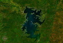
A reservoir is an enlarged lake behind a dam. Such a dam may be either artificial, usually built to store fresh water, or it may be a natural formation.

<span class="mw-page-title-main">Elwha Dam</span> Dam in Washington, USA

The Elwha Dam was a 108-ft high dam located in the United States, in the state of Washington, on the Elwha River approximately 4.9 miles (7.9 km) upstream from the mouth of the river on the Strait of Juan de Fuca.

<span class="mw-page-title-main">Urban runoff</span> Surface runoff of water caused by urbanization

Urban runoff is surface runoff of rainwater, landscape irrigation, and car washing created by urbanization. Impervious surfaces are constructed during land development. During rain, storms, and other precipitation events, these surfaces, along with rooftops, carry polluted stormwater to storm drains, instead of allowing the water to percolate through soil. This causes lowering of the water table and flooding since the amount of water that remains on the surface is greater. Most municipal storm sewer systems discharge untreated stormwater to streams, rivers, and bays. This excess water can also make its way into people's properties through basement backups and seepage through building wall and floors.

<span class="mw-page-title-main">Dam removal</span>

Dam removal is the process of demolishing a dam, returning water flow to the river. Arguments for dam removal consider whether their negative effects outweigh their benefits. The benefits of dams include hydropower production, flood control, irrigation, and navigation. Negative effects of dams include environmental degradation, such as reduced primary productivity, loss of biodiversity, and declines in native species; some negative effects worsen as dams age, like structural weakness, reduced safety, sediment accumulation, and high maintenance expense. The rate of dam removals in the United States has increased over time, in part driven by dam age. As of 1996, 5,000 large dams around the world were more than 50 years old. In 2020, 85% percent of dams in the United States are more than 50 years old. In the United States roughly 900 dams were removed between 1990 and 2015, and by 2015, the rate was 50 to 60 per year. France and Canada have also completed significant removal projects. Japan's first removal, of the Arase Dam on the Kuma River, began in 2012 and was completed in 2017. A number of major dam removal projects have been motivated by environmental goals, particularly restoration of river habitat, native fish, and unique geomorphological features. For example, fish restoration motivated the Elwha Ecosystem Restoration and the dam removal on the river Allier, while recovery of both native fish and of travertine deposition motivated the restoration of Fossil Creek.

<span class="mw-page-title-main">Avulsion (river)</span> Rapid abandonment of a river channel and formation of a new channel

In sedimentary geology and fluvial geomorphology, avulsion is the rapid abandonment of a river channel and the formation of a new river channel. Avulsions occur as a result of channel slopes that are much less steep than the slope that the river could travel if it took a new course.

<span class="mw-page-title-main">Environmental effects of irrigation</span> Land & irrigation

The environmental effects of irrigation relate to the changes in quantity and quality of soil and water as a result of irrigation and the subsequent effects on natural and social conditions in river basins and downstream of an irrigation scheme. The effects stem from the altered hydrological conditions caused by the installation and operation of the irrigation scheme.

<span class="mw-page-title-main">Ebro</span> River in the Iberian Peninsula

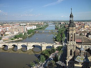
The Ebro is a river of the north and northeast of the Iberian Peninsula, in Spain. It rises in Cantabria and flows 930 kilometres (580 mi), almost entirely in an east-southeast direction. It flows into the Mediterranean Sea forming a delta in the Province of Tarragona, in southern Catalonia. In the Iberian peninsula, it ranks second in length after the Tagus and second in discharge volume, and drainage basin, after the Douro. It is the longest river entirely within Spain; the other two mentioned flow into Portugal. It is also the second-longest river in the Mediterranean basin, after the Nile.

A mouth bar is an element of a deltaic system, which refers to the typically mid-channel deposition of the sediment transported by the river channel at the river mouth.

<span class="mw-page-title-main">Alluvial river</span> Type of river

An alluvial river is one in which the bed and banks are made up of mobile sediment and/or soil. Alluvial rivers are self-formed, meaning that their channels are shaped by the magnitude and frequency of the floods that they experience, and the ability of these floods to erode, deposit, and transport sediment. For this reason, alluvial rivers can assume a number of forms based on the properties of their banks; the flows they experience; the local riparian ecology; and the amount, size, and type of sediment that they carry.

<span class="mw-page-title-main">Shihmen Dam</span> Dam in Taoyuan City, Taiwan

Shihmen Dam is a major rock fill dam across the Dahan River in northern Taoyuan City. It forms the Shihmen Reservoir (石門水庫), Taiwan's third largest reservoir or artificial lake. It provides irrigation in Taoyuan, flood control for the Taipei Basin, and hydroelectricity and domestic water supply for more than three million people in northern Taiwan.

The Kishanganga Hydroelectric Project is a run-of-the-river hydroelectric scheme in Jammu and Kashmir, India. Its dam diverts water from the Kishanganga River to a power plant in the Jhelum River basin. It is located near Dharmahama Village, 5 km (3 mi) north of Bandipore in the Kashmir valley and has an installed capacity of 330 MW.

Legacy sediment (LS) is depositional bodies of sediment inherited from the increase of human activities since the Neolithic. These include a broad range of land use and land cover changes, such as agricultural clearance, lumbering and clearance of native vegetation, mining, road building, urbanization, as well as alterations brought to river systems in the form of dams and other engineering structures meant to control and regulate natural fluvial processes (erosion, deposition, lateral migration, meandering). The concept of LS is used in geomorphology, ecology, as well as in water quality and toxicological studies.

<span class="mw-page-title-main">Sedimentation enhancing strategy</span>

Sedimentation enhancing strategies are environmental management projects aiming to restore and facilitate land-building processes in deltas. Sediment availability and deposition are important because deltas naturally subside and therefore need sediment accumulation to maintain their elevation, particularly considering increasing rates of sea-level rise. Sedimentation enhancing strategies aim to increase sedimentation on the delta plain primarily by restoring the exchange of water and sediments between rivers and low-lying delta plains. Sedimentation enhancing strategies can be applied to encourage land elevation gain to offset sea-level rise. Interest in sedimentation enhancing strategies has recently increased due to their ability to raise land elevation, which is important for the long-term sustainability of deltas.

References

  1. Schmutz, Stefan; Moog, Otto (2018), Schmutz, Stefan; Sendzimir, Jan (eds.), "Dams: Ecological Impacts and Management", Riverine Ecosystem Management, Cham: Springer International Publishing, pp. 111–127, doi: 10.1007/978-3-319-73250-3_6 , ISBN   978-3-319-73249-7
  2. 1 2 A comparative survey of dam-induced resettlement in 50 cases by Thayer Scudder and John Gray
  3. 1 2 Mann, Charles C; Mark L. Plummer (August 2000). "Can Science Rescue Salmon?". Science. New Series. 289 (5480): 716–719. doi:10.1126/science.289.5480.716. PMID   10950712. S2CID   129268573.
  4. Silenced Rivers: The Ecology and Politics of Large Dams, by Patrick McCully, Zed Books, London, 1996. ISBN   1-85649-902-2
  5. 1 2 Reservoir Sedimentation Handbook; Morris, Gregory & Fan, Jiahua; McGraw-Hill Publishers; 1998.
  6. 1 2 Kondolf, G. M.; Gao, Y.; Annandale, G. W.; Morris, G. L.; Jiang, E.; Zhang, J.; Cao, Y; Carling, P.; Fu, K.; Guo, Q.; Hotchkiss, Rollin (2014). "Sustainable sediment management in reservoirs and regulated rivers: Experiences from five continents". Earth's Future. 2 (5): 256–280. Bibcode:2014EaFut...2..256K. doi: 10.1002/2013EF000184 . ISSN   2328-4277.
  7. 1 2 3 Rovira, A.; Ibàñez, C. (2007). "Sediment management options for the lower Ebro River and its delta". Journal of Soils and Sediments. 7 (5): 285–295. doi:10.1065/jss2007.08.244. ISSN   1439-0108. S2CID   97748305.
  8. 1 2 Batalla, R. J.; Vericat, D. (2009). "Hydrological and sediment transport dynamics of flushing flows: implications for management in large Mediterranean Rivers". River Research and Applications. 25 (3): 297–314. Bibcode:2009RivRA..25..297B. doi:10.1002/rra.1160. S2CID   129530817.
  9. Gómez, C. M.; Pérez-Blanco, C. D.; Batalla, R. J. (2014). "Tradeoffs in river restoration: Flushing flows vs. hydropower generation in the Lower Ebro River, Spain". Journal of Hydrology. 518: 130–139. Bibcode:2014JHyd..518..130G. doi:10.1016/j.jhydrol.2013.08.029.
  10. Tena, A.; Vericat, D.; Batalla, R. J. (2014). "Suspended sediment dynamics during flushing flows in a large impounded river (the lower River Ebro)". Journal of Soils and Sediments. 14 (12): 2057–2069. doi:10.1007/s11368-014-0987-0. ISSN   1614-7480. S2CID   55058640.
  11. Kondolf, G. M.; Annandale, G.; Rubin, Z. (2015). "Sediment starvation from dams in the lower Mekong river basin: Magnitude of effect and potential mitigation opportunities". 36th IAHR World Congress.
  12. Auel, C.; Berchtold, T.; Boes, R. M. (2010). "Sediment management in the Solis Reservoir using a bypass tunnel". Dam Safety: Sustainability in a Changing Environment; Proceedings of the 8th ICOLD European Club Symposium. Verlag der Technischen Universität Graz: 455–460. ISBN   978-3-85125-118-0.
  13. Boes, R. M.; Auel, C.; Müller-Hagmann, M.; Albayrak, I. (2014). "Sediment bypass tunnels to mitigate reservoir sedimentation and restore sediment continuity". Reservoir sedimentation. CRC Press, Taylor and Francis Group. pp. 221–228.
  14. Warrick, Jonathan A.; Stevens, Andrew W.; Miller, Ian M.; Harrison, Shawn R.; Ritchie, Andrew C.; Gelfenbaum, Guy (2019-09-27). "World's largest dam removal reverses coastal erosion". Scientific Reports. 9 (1): 13968. Bibcode:2019NatSR...913968W. doi:10.1038/s41598-019-50387-7. ISSN   2045-2322. PMC   6764949 . PMID   31562373.
  15. Sedimentation Engineering; American Society of Civil Engineers Committee; American Society of Civil Engineers Headquarters; 1975.
  16. Dai, Zhijun; Liu, James T. (2013-02-14). "Impacts of large dams on downstream fluvial sedimentation: An example of the Three Gorges Dam (TGD) on the Changjiang (Yangtze River)". Journal of Hydrology. 480: 10–18. Bibcode:2013JHyd..480...10D. doi:10.1016/j.jhydrol.2012.12.003.
  17. Gies, Erica (3 May 2023). "The Oceans Are Missing Their Rivers". Nautilus Quarterly . Retrieved 5 May 2023.
  18. Maavara, Taylor; Chen, Qiuwen; Van Meter, Kimberly; Brown, Lee E.; Zhang, Jianyun; Ni, Jinren; Zarfl, Christiane (February 2020). "River dam impacts on biogeochemical cycling". Nature Reviews Earth & Environment. 1 (2): 103–116. Bibcode:2020NRvEE...1..103M. doi:10.1038/s43017-019-0019-0. ISSN   2662-138X. S2CID   211006052.
  19. Josette, Garnier; Leporcq, Bruno; Sanchez, Nathalie; Philippon, Xavier (1999). "Biogeochemical mass-balances (C, N, P, Si) in three large reservoirs of the Seine Basin (France)". Biogeochemistry. 47 (2): 119–146. doi:10.1023/A:1006101318417. S2CID   95558971.
  20. Friedl, Gabriela; Wüest, Alfred (April 2002). "Disrupting biogeochemical cycles - Consequences of damming". Aquatic Sciences. 64 (1): 55–65. doi:10.1007/s00027-002-8054-0. S2CID   44859140.
  21. Humborg, Christoph; Conley, Daniel J.; Rahm, Lars; Wulff, Fredrik; Cociasu, Adriana; Ittekkot, Venugopalan (February 2000). "Silicon Retention in River Basins: Far-reaching Effects on Biogeochemistry and Aquatic Food Webs in Coastal Marine Environments". Ambio: A Journal of the Human Environment. 29 (1): 45–50. doi:10.1579/0044-7447-29.1.45. ISSN   0044-7447. S2CID   86019928.
  22. Turner, R. E.; Qureshi, N.; Rabalais, N. N.; Dortch, Q.; Justic, D.; Shaw, R. F.; Cope, J. (1998-10-27). "Fluctuating silicate:nitrate ratios and coastal plankton food webs". Proceedings of the National Academy of Sciences. 95 (22): 13048–13051. Bibcode:1998PNAS...9513048T. doi: 10.1073/pnas.95.22.13048 . ISSN   0027-8424. PMC   23704 . PMID   9789038.
  23. Aleem, A. A. (August 1972). "Effect of river outflow management on marine life". Marine Biology. 15 (3): 200–208. doi:10.1007/BF00383550. ISSN   0025-3162. S2CID   84575211.
  24. 1 2 Lugg, Allan (2014). "Review of cold water pollution in the Murray-Darling Basin and the impacts on fish communities". Ecological Management & Restoration. 15 (1): 71–79. Bibcode:2014EcoMR..15...71L. doi:10.1111/emr.12074.
  25. West, Richard (2010). "Shad Monitoring in the Afon Tywi SAC: A Case Study" . In Hurford, Clive; Schneider, Michael; Cowx, Ian (eds.). Conservation Monitoring in Freshwater Habitats . Springer Dordrecht. pp. 219–230. doi:10.1007/978-1-4020-9278-7. ISBN   978-1-4020-9277-0. ISSN   0343-6993.
  26. "Burrendong temperature control structure". StateWater.com.au. WaterNSW. Archived from the original on 2015-09-23. Retrieved 2015-09-22.
  27. Stobbe Reimer, Asha Miriam (2021-09-30). "Tasmanian Wilderness Society blocks dam construction (Franklin River Campaign) 1981-83". The Commons Social Change Library. Retrieved 2023-07-07.
  28. ILRI, 1982. Modern interferences in traditional water resources in Baluchistan . In: Annual Report 1982, pp. 23-34. ILRI, Wageningen, The Netherlands. Reprinted in Water International 9 (1984), pp. 106- 111. Elsevier Sequoia, Amsterdam. Also reprinted in Water Research Journal (1983) 139, pp. 53-60.
  29. A. deGeorges and B.K. Reilly, 2006. Dams and large scale irrigation on the Senegal river: impacts on man and the environment . UNDP Human Development Report.
  30. C.A.Drijver and M.Marchand, 1985. Taming the floods. Environmental aspects of the floodplain developments of Africa. Centre of Environmental Studies, University of Leiden, The Netherlands.
  31. 1 2 Kelly, C. A.; Rudd, J. W. M.; Bodaly, R. A.; Roulet, N. P.; St.Louis, V. L.; Heyes, A.; Moore, T. R.; Schiff, S.; Aravena, R.; Scott, K. J.; Dyck, B. (May 1997). "Increases in Fluxes of Greenhouse Gases and Methyl Mercury following Flooding of an Experimental Reservoir". Environmental Science & Technology. 31 (5): 1334–1344. doi:10.1021/es9604931. ISSN   0013-936X. S2CID   129247176.
  32. St.Louis, Vincent L.; Rudd, John W. M.; Kelly, Carol A.; Bodaly, R. A. (Drew); Paterson, Michael J.; Beaty, Kenneth G.; Hesslein, Raymond H.; Heyes, Andrew; Majewski, Andrew R. (March 2004). "The Rise and Fall of Mercury Methylation in an Experimental Reservoir†". Environmental Science & Technology. 38 (5): 1348–1358. Bibcode:2004EnST...38.1348S. doi:10.1021/es034424f. ISSN   0013-936X. PMID   15046335.
  33. William R. Jobin, 1999. Dams and Disease: Ecological Design and Health Impacts of Large Dams, Canals, and Irrigation Systems , Taylor & Francis, ISBN   0-419-22360-6
  34. 1 2 Climate Change and Dams: An Analysis of the Linkages Between the UNFCCC Legal Regime and Dams.
  35. Graham-Rowe, Duncan (2005). "Hydroelectric Power's Dirty Secret Revealed", NewScientist.com.
  36. Lima, Ivan B. T. (2007). "Methane Emissions from Large Dams as Renewable Energy Resources: A Developing Nation Perspective". Mitigation and Adaptation Strategies for Global Change. 13 (2): 193–206. doi:10.1007/s11027-007-9086-5. S2CID   27146726.
  37. Kemenes, Alexandre; Forsberg, Bruce R.; Melack, John M. (September 2011). "CO₂ emissions from a tropical hydroelectric reservoir (Balbina, Brazil)". Journal of Geophysical Research . 116 (G3): G03004. Bibcode:2011JGRG..116.3004K. doi: 10.1029/2010jg001465 .
  38. Grossman, Daniel (18 September 2019). "Deliberate drowning of Brazil's rainforest is worsening climate change". New Scientist . Retrieved 30 September 2020.
  39. Matthews, Cory J. D.; Joyce, Elizabeth M.; Louis, Vincent L. St.; Schiff, Sherry L.; Venkiteswaran, Jason J.; Hall, Britt D.; Bodaly, R. A. (Drew); Beaty, Kenneth G. (April 2005). "Carbon Dioxide and Methane Production in Small Reservoirs Flooding Upland Boreal Forest". Ecosystems. 8 (3): 267–285. doi:10.1007/s10021-005-0005-x. ISSN   1432-9840. S2CID   30088541.
  40. St. Louis, Vincent L.; Kelly, Carol A.; Duchemin, Éric; Rudd, John W. M.; Rosenberg, David M. (2000). "Reservoir Surfaces as Sources of Greenhouse Gases to the Atmosphere: A Global Estimate" (PDF). BioScience. 50 (9): 766–755. doi: 10.1641/0006-3568(2000)050[0766:RSASOG]2.0.CO;2 .