Fortifications of London

Last updated

Statue of the Emperor Trajan in front of a section of the London Wall at Tower Hill. The wall's lower Roman section can be identified by its bands of clay tiles. London wall statue.jpg
Statue of the Emperor Trajan in front of a section of the London Wall at Tower Hill. The wall's lower Roman section can be identified by its bands of clay tiles.

The fortifications of London are extensive and mostly well maintained, though many of the City of London's fortifications and defences were dismantled in the 17th and 18th century. Many of those that remain are tourist attractions, most notably the Tower of London.

Contents

History

Roman times

London's first defensive wall was built by the Romans around 200 AD. This was around 80 years after the construction of the city's fort (whose north and west walls were thickened and doubled in height to form part of the new city wall), and 150 years after the city was founded as Londinium.

The London Wall remained in active use as a fortification for over 1,000 years afterwards, defending London against raiding Saxons in 457 and surviving into Medieval times. There were six main entrances through the wall into the City, five built by the Romans at different times in their occupation of London.

These were, going clockwise from Ludgate in the west to Aldgate in the east: Ludgate, Newgate, Aldersgate, Cripplegate, Bishopsgate and Aldgate. A seventh, Moorgate, was added in Medieval times between Cripplegate and Bishopsgate.

Middle ages

After the Norman conquest in 1066 the city fortifications were added to, as much to protect the Normans from the people of the City of London as to protect London from outside invaders. King William had two fortifications built:

A third fortification, Montfichet's Castle, was built to the north west by Gilbert de Monfichet, a native of Rouen, and relative of William.

The Tower of London in 1597 Tower plan.JPG
The Tower of London in 1597

Later in the medieval period the walls were redeveloped with the addition of crenellations, more gates and further bastions.

City gates

The portals that once guarded the entrances to the City of London through the City Wall were multi-storey buildings that had one or two archways through the middle for traffic, protected by gates and portcullises. They were often used as prisons, or used to display executed criminals to passers-by. Beheaded traitors often had their head stuck on a spike on London Bridge, then their body quartered and spread among the gates.

After the curfew, rung by the bells of St Mary le Bow and other churches at nine o'clock, or dusk, (whichever came earlier) the gates were shut. They reopened at sunrise, or at six o'clock the next morning, whichever came later. Entry was forbidden during these times, and citizens inside the gates were required to remain in their homes. The gates were also used as checkpoints, to check people entering the City, and to collect any tolls that were being charged for the upkeep of the wall, or any other purpose that might require money. It is possible that the wall was maintained for the sole purpose of collecting taxes, and not for defence at all.

The gates were repaired and rebuilt many times. After the restoration of the monarchy in 1660 all of the city gates were unhinged and had their portcullises wedged open, rendering them defenceless, but they were retained as a visible sign of the prestige of the city. Most of the gates were demolished around 1760 due to traffic congestion.

The positions of all the gates are now marked by a main road with the same name, except for Cripplegate, which is a tiny street somewhat north of the position of that gate.

London Bridge

"Old London Bridge was itself fortified against attack. The Southwark end of the bridge was defended by the Great Stone Gate, which was probably completed along with the rest of the bridge in 1209 and was built on the third pier from the bank. In January 1437, the whole gatehouse collapsed into the Thames but was rebuilt from 1465 to 1466. A second line of defence was provided by a drawbridge which spanned the seventh and eighth piers. First mentioned in 1257, it was probably supported by a wooden tower at first, but this was replaced by a stone gatehouse between 1426 and 1428, known as the Drawbridge Gate or the New Stone Gate. The drawbridge served a double function; firstly it could form an impassable barrier to any force attacking from the south and secondly, whilst allowing merchant vessels to pass upstream to the dock at Queenhithe, when lowered it could prevent enemy ships from passing to attack from the rear. The Drawbridge Gate was demolished in 1577. Although the Great Stone Gate was demolished and rebuilt in 1727, it had little military function and was demolished completely in 1760. [1]

17th century

A model of the fortifications built around London during the English Civil War viewed from the east. Lines of Communication (London).jpg
A model of the fortifications built around London during the English Civil War viewed from the east.

19th century

World War I

During World War I, part of the London Defence Positions scheme was resurrected to form a stop line in the event of a German invasion. North of the Thames the line was continued to the River Lea at Broxbourne and south of the Thames, it was extended to Halling, Kent, thus linking to the Chatham defences.

World War II and later

The Admiralty Citadel in 2008. Admiralty Citadel2008.jpg
The Admiralty Citadel in 2008.

Further preparations were made for the defence of London during World War II with the threat of invasion in 1940. These preparations comprised building shelters and fortifications against air attack in the city itself, and preparing defence positions outside the city against the possibility of land attack. GHQ Line was the longest and most important of a number of anti-tank Stop Lines, it was placed to protect London and the industrial heartland of England. GHQ Line ran East from the Bristol area, much of it along the Kennet and Avon canal; it turned south at Reading and wrapped round London passing just south of Aldershot and Guildford; and then headed north through Essex and towards Edinburgh. Inside the GHQ Line there were complete rings of defences, the Outer (Line A), Central (Line B) and Inner (Line C) London Defence Rings.

In the city the Cabinet War Rooms and the Admiralty Citadel were built to protect command and control centres, and a series of deep-level shelters prepared, as refuge for the general population against bombing. In June 1940 under the direction of General Edmund Ironside, concentric rings of anti-tank defences and pillboxes were constructed: The London Inner Keep, London Stop Line Inner (Line C), London Stop Line Central (Line B) and London Stop Line Outer (Line A). [3] Work on these lines was halted weeks later by Ironside's successor, General Alan Brooke, [4] who favoured mobile warfare above static defence.

Following the end of World War II and with the advent of the Cold War era, further hardened defences were prepared in the city to protect command and control structures. A number of citadels were improved, and new ones built, including PINDAR, Kingsway telephone exchange and, possibly, Q-Whitehall, though much of this work is still regarded as secret.

Terrorism defences

London is a major terrorist target, having been subjected to repeated Provisional Irish Republican Army (IRA) bombings during the Troubles and more recently 7 July 2005 London bombings by Muslim extremists. In the late 1980s the IRA planned a campaign to disrupt the City of London. Two massive truck bombs were exploded in the City of London: the Baltic Exchange bomb on 10 April 1992, and just over a year later the Bishopsgate bombing. The Corporation of the City of London responded by altering the layout of access roads to the city and putting in checkpoints to be manned when the threat level warrants it; these measures are known as the "ring of steel" a name taken from the more formidable defences that, at that time, ringed the centre of Belfast.

The rest of London (with the exception of obvious targets such as Whitehall, the Palace of Westminster, the Royal residences, the airports and some embassies) do not have such overt protection, but London is heavily monitored by CCTV, and many other landmark buildings now have concrete barriers to defend against truck bombs.

See also

Notes

  1. Pierce, Patricia (2001), Old London Bridge, Headline Book Publishing, ISBN   978-0-747-23493-7 (pp. 318-329)
  2. The modeby is by artist group craft:pegg, located in Bishops Square, Spitalfields Market
  3. "London Pillboxes and Anti-Invasion Defences". Archived from the original on 1 February 2010. Retrieved 4 November 2009.
  4. Alanbrooke, Field Marshal Lord (edited by Alex Danchev and Daniel Todman) (2001). War Diaries 1939-1945. Phoenix Press. ISBN   1-84212-526-5.

Related Research Articles

<span class="mw-page-title-main">City of London</span> Central business district of London, England

The City of London is a city, ceremonial county and local government district that contains the historic centre and constitutes, alongside Canary Wharf, the primary central business district (CBD) of London. It constituted most of London from its settlement by the Romans in the 1st century AD to the Middle Ages, but the modern area named London has since grown far beyond the City of London boundary. The City is now only a small part of the metropolis of Greater London, though it remains a notable part of central London. Administratively, the City of London is not one of the London boroughs, a status reserved for the other 32 districts. It is also a separate ceremonial county, being an enclave surrounded by Greater London, and is the smallest ceremonial county in the United Kingdom.

<span class="mw-page-title-main">Defensive wall</span> Fortification used to protect an area from potential aggressors

A defensive wall is a fortification usually used to protect a city, town or other settlement from potential aggressors. The walls can range from simple palisades or earthworks to extensive military fortifications with towers, bastions and gates for access to the city. From ancient to modern times, they were used to enclose settlements. Generally, these are referred to as city walls or town walls, although there were also walls, such as the Great Wall of China, Walls of Benin, Hadrian's Wall, Anastasian Wall, and the Atlantic Wall, which extended far beyond the borders of a city and were used to enclose regions or mark territorial boundaries. In mountainous terrain, defensive walls such as letzis were used in combination with castles to seal valleys from potential attack. Beyond their defensive utility, many walls also had important symbolic functions – representing the status and independence of the communities they embraced.

<span class="mw-page-title-main">Fortification</span> Military defensive construction

A fortification is a military construction or building designed for the defense of territories in warfare, and is also used to establish rule in a region during peacetime. The term is derived from Latin fortis ("strong") and facere.

<span class="mw-page-title-main">Aldgate</span> Human settlement in England

Aldgate was a gate in the former defensive wall around the City of London. It gives its name to Aldgate High Street, the first stretch of the A11 road, which included the site of the former gate.

<span class="mw-page-title-main">GHQ Line</span> Defence line built in the United Kingdom during World War II

The GHQ Line was a defence line built in the United Kingdom during World War II to contain an expected German invasion.

<span class="mw-page-title-main">Bishopsgate</span> Ward of the City of London

Bishopsgate was one of the eastern gates in London's former defensive wall. The gate's name is traditionally attributed to Earconwald, who was Bishop of London in the 7th century. It was first built in Roman times and marked the beginning of Ermine Street, the ancient road running from London to York (Eboracum). The gate was rebuilt twice in the 15th and 18th centuries, but was permanently demolished in 1760.

<span class="mw-page-title-main">London Wall</span> Defensive wall built around London

The London Wall was a defensive wall first built by the Romans around the strategically important port town of Londinium in c. AD 200, and is now the name of a modern street in the City of London.

<span class="mw-page-title-main">Fortifications of Portsmouth</span>

The fortifications of Portsmouth are extensive due to its strategic position on the English Channel and role as home to the Royal Navy. For this reason, Portsmouth was, by the 19th century, one of the most fortified cities in the world. The fortifications have evolved over the centuries in response to changes in tactics and technology and the area defended has increased. While the first defences focused on Portsmouth harbour, in step with the fortifications of Gosport, later defensive structures protected the whole of Portsea Island and an increasing distance inland. At the same time, the fortifications of Portsmouth and Gosport became part of the wider fortifications of the Solent. Old Portsmouth, on the southwest corner of Portsea Island, has been walled for much of its history.

<span class="mw-page-title-main">Tilbury Fort</span> Fortification in England

Tilbury Fort, also known historically as the Thermitage Bulwark and the West Tilbury Blockhouse, is an artillery fort on the north bank of the River Thames in England. The earliest version of the fort, comprising a small blockhouse with artillery covering the river, was constructed by King Henry VIII to protect London against attack from France as part of his Device programme. It was reinforced during the 1588 Spanish Armada invasion scare, after which it was reinforced with earthwork bastion, and Parliamentary forces used it to help secure the capital during the English Civil War of the 1640s. Following naval raids during the Anglo-Dutch Wars, the fort was enlarged by Sir Bernard de Gomme from 1670 onwards to form a star-shaped defensive work, with angular bastions, water-filled moats and two lines of guns facing onto the river.

<span class="mw-page-title-main">Upnor Castle</span> Fort in Kent, England

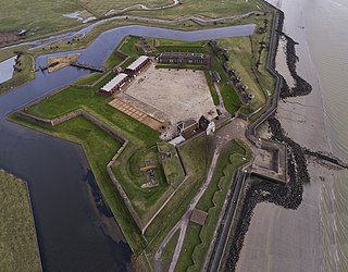
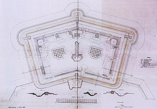
Upnor Castle is an Elizabethan artillery fort located on the west bank of the River Medway in Kent. It is in the village of Upnor, opposite and a short distance downriver from the Chatham Dockyard, at one time a key naval facility. The fort was intended to protect both the dockyard and ships of the Royal Navy anchored in the Medway. It was constructed between 1559–67 on the orders of Elizabeth I, during a period of tension with Spain and other European powers. The castle consists of a two-storeyed main building protected by a curtain wall and towers, with a triangular gun platform projecting into the river. It was garrisoned by about 80 men with a peak armament of around 20 cannon of various calibres.

<span class="mw-page-title-main">St Botolph's Aldgate</span> Church in London, England

St Botolph's Aldgate is a Church of England parish church in the City of London and also, as it lies outside the line of the city's former eastern walls, a part of the East End of London. The church served the ancient parish of St Botolph without Aldgate which included the extramural Portsoken Ward of the City of London, as well as East Smithfield which is outside the City.

<span class="mw-page-title-main">St Botolph-without-Bishopsgate</span> Church in the City of London

St Botolph-without-Bishopsgate is a Church of England church in the Bishopsgate Without area of the City of London, and also, by virtue of lying outside the city's eastern walls, part of London's East End.

<span class="mw-page-title-main">Halle Gate</span> Former city gate in Brussels, Belgium

The Halle Gate is a former medieval city gate and the last vestige of the second walls of Brussels, Belgium. Built between 1381 and 1383, it was heavily restored in the 19th century in its current neo-Gothic style by the architect Henri Beyaert. It is now a museum dedicated to the medieval City of Brussels, part of the Royal Museums of Art and History (RMAH).

<span class="mw-page-title-main">East End of London</span> Area of London, England

The East End of London, often referred to within the London area simply as the East End, is the historic core of wider East London, east of the Roman and medieval walls of the City of London and north of the River Thames. It does not have universally accepted boundaries to the north and east, though the River Lea is sometimes seen as the eastern boundary. Parts of it may be regarded as lying within Central London. The term "East of Aldgate Pump" is sometimes used as a synonym for the area.

<span class="mw-page-title-main">Wards of the City of London</span> Special form of ward in the City of London

The City of London is divided into 25 wards. The city is the historic core of the much wider metropolis of Greater London, with an ancient and sui generis form of local government, which avoided the many local government reforms elsewhere in the country in the 19th and 20th centuries. Unlike other modern English local authorities, the City of London Corporation has two council bodies: the now largely ceremonial Court of Aldermen, and the Court of Common Council.

<span class="mw-page-title-main">Walls of Amsterdam</span> Series of historic walls built around the city of Amsterdam, Netherlands

The walls of Amsterdam were built in the Middle Ages to protect the city against attack. The Medieval walls were replaced with a series of bastions in the 17th century. In the 19th century, the walls were torn down and replaced with the Defence Line of Amsterdam, a fortification line which encircled Amsterdam at a distance from the city.

<span class="mw-page-title-main">Zwinger</span> Area between main and secondary walls of a fortification

"Zwinger" is a German word for outer ward or outer bailey. It represents an open kill zone area between two defensive walls that is used for defensive purposes. Zwingers were built in the post-classical and early modern periods to improve the defence of castles and town walls. The term is usually left untranslated, but is sometimes rendered as "outer courtyard", presumably referring to the subsequent role of a Zwinger as a castle's defences became redundant and it was converted into a palace or schloss; however, this belies its original purpose as a form of killing ground for the defence. The word is linked with zwingen, "to force", perhaps because the Zwinger forced an enemy to negotiate it before assaulting the main defensive line. Essenwein states that the "main purpose of this feature was so that the besieging force could not reach the actual castle wall very easily with battering rams or belfries, but had to stop at the lower, outer wall; also that two ranks of archers, behind and above one another, could fire upon the approaching enemy".

<span class="mw-page-title-main">Bridge tower</span>

A bridge tower was a type of fortified tower built on a bridge. They were typically built in the period up to early modern times as part of a city or town wall or castle. There is usually a tower at both ends of the bridge. During the 19th century, a number of bridge towers were built in the Gothic Revival style – Tower Bridge in London is perhaps the best known example; however, many original medieval towers survive across Europe.

<span class="mw-page-title-main">Polygonal fort</span> Type of fortification

A polygonal fort is a type of fortification originating in France in the late 18th century and fully developed in Germany in the first half of the 19th century. Unlike earlier forts, polygonal forts had no bastions, which had proved to be vulnerable. As part of ring fortresses, polygonal forts were generally arranged in a ring around the place they were intended to protect, so that each fort could support its neighbours. The concept of the polygonal fort proved to be adaptable to improvements in the artillery which might be used against them, and they continued to be built and rebuilt well into the 20th century.

<span class="mw-page-title-main">Siege of London (1471)</span> Battle during the War of the Roses

The siege of London was an episode of the Wars of the Roses between 12 and 15 May 1471, in which adherents of the House of Lancaster commanded by Thomas Neville unsuccessfully attempted to storm the city and free King Henry VI, who had been imprisoned in the Tower of London by his rival Edward IV of the House of York. This confrontation, which was an epilogue to the recent battles of Barnet and Tewkesbury, completed the final restoration of Edward IV and ensured the Yorkist hold on the throne.

References