Cripplegate

Last updated

Ward of Cripplegate
Greater London UK location map 2.svg
Red pog.svg
Ward of Cripplegate
Location within Greater London
Population2,782 (2011 Census. Ward) [1]
OS grid reference TQ327811
Sui generis
Administrative area Greater London
Region
Country England
Sovereign state United Kingdom
Post town LONDON
Postcode district EC2
Dialling code 020
Police City of London
Fire London
Ambulance London
UK Parliament
London Assembly
List of places
UK
England
London
51°31′05″N0°05′35″W / 51.518087°N 0.0931473°W / 51.518087; -0.0931473

Cripplegate was a gate in the London Wall which once enclosed the City of London, England.

Contents

The Cripplegate gate lent its name to the Cripplegate ward of the City, which encompasses the area where the gate and the former city wall once stood. The ward is divided into two parts: Cripplegate Within and Cripplegate Without, [2] a division that originated from the gate and wall. Each part has a designated beadle and a deputy (alderman). Following boundary changes in 1994 (City) and 2003 (ward), the majority of the ward now falls within Cripplegate Without, as the ward of Bassishaw has expanded significantly into the Cripplegate Within area.

Until World War II, the area approximating to Cripplegate Without was commonly known as simply Cripplegate. The area was almost entirely destroyed in the Blitz of World War II, causing the term to fall out of colloquial speech. Cripplegate Without is the site of the Barbican Estate and Barbican Centre, with a small part of these lying in neighbouring Aldersgate Without.

The gate

An illustration of the gate, c. 1650. Cripplegate Hollar.PNG
An illustration of the gate, c. 1650.
Cripplegate plaque Cripplegate plaque.jpg
Cripplegate plaque

The origins of the gate's name are unclear. [3] One theory, bolstered by a mentioning of the gate in the fourth law code of Æthelred the Unready and a charter of William the Conqueror from 1068 under the name "Crepelgate", [4] is that it takes its name from the Anglo-Saxon word crepel, meaning a covered or underground passageway.

Another unsubstantiated theory suggests it is named after the cripples who used to beg there. [5] The name of the nearby medieval church of St Giles-without-Cripplegate lends credence to this suggestion as Saint Giles is the patron saint of cripples and lepers.

History of the gate

It was initially the northern gate to the Roman city walls, built around AD 120 or 150, [6] eighty years before the rest of the wall was completed. It appeared to have been used as part of the Roman city walls until at least the 10th-11th centuries. Cripplegate was rebuilt during the 1490s and was unhinged and fortified with a portcullis after Charles II became king in 1660. It was eventually demolished in 1760; much of Cripplegate was gone by the 19th century and only small fragments of it survive today.

The ward

Location within the City, after the 21st century boundary changes City of London, Ward of Cripplegate.svg
Location within the City, after the 21st century boundary changes
Ancient boundaries of the City Wards, prior to 2003 City of London Ward Map, 1870.svg
Ancient boundaries of the City Wards, prior to 2003

Cripplegate is one of the 25 ancient wards of the City of London, each electing an alderman to the Court of Aldermen and commoners (the City equivalent of a councillor) to the Court of Common Council of the City of London Corporation. Only electors who are Freemen of the City are eligible to stand. In the early 12th century, the area was originally referred to as Alwoldii which was probably the name of the current alderman. [7] The early records are unreliable as regards who the Aldermen were, but from 1286 there is a more reliable list of Aldermen available. [7]

The modern City of London spreads across a square mile of land and remains divided into 25 geographic areas, or 'wards'. Four of these wards (Aldersgate, Portsoken, Queenhithe and Cripplegate), are described as 'residential' as they contain the vast majority of all City residents.

Geography

The Ward of Cripplegate provides part of the Northern edge of the City and stretches from just below Old Street, down to London Wall at its southern tip, where it meets the Ward of Bassishaw. To the west is the Ward of Aldersgate and on the Eastern edge is Coleman Street.

The 2003 Ward Boundary Review recommended some significant changes for a number of wards and these were eventually implemented in 2013. [7]

The Cripplegate Ward boundary used to extend a great deal further south, all the way down to Cheapside in fact. The ward was home to the halls of six livery companies and now only one remains (the Barber-Surgeons in Monkwell Square). [7]

Each ward is represented by an assembly called the 'Court of Common Council'. This consists of 100 common councilmen and 25 alderman (one for each Ward). The number of councilmen allocated to each particular ward is based on the size of the electorate and where Cripplegate used to warrant twelve members of council it is now reduced to nine. [7]

The ward is promoted by the Cripplegate Ward Club. Founded in 1878, The Cripplegate Ward Club is a social organisation, encouraging its members to take an interest in the civic affairs of the City, while also supporting appeals and charitable activities. Cripplegate is among the busiest of the 20-plus ward clubs in the City of London, with a varied programme of events throughout the year.

Jewin Crescent painting at the Imperial War Museum Jewin Crescent.jpg
Jewin Crescent painting at the Imperial War Museum

The gate's name is preserved in the church of St Giles-without-Cripplegate which is sited immediately outside the site of the former gate.

A small road named Cripplegate Street lies slightly to the north of the site of the gate between Viscount Street and Bridgewater Street. [8]

History of the ward

The wards of London appear to have taken shape in the 11th century, before the Norman Conquest. Their administrative, judicial and military purpose made them equivalent to Hundreds in the countryside. The primary purpose of wards like Cripplegate, which included a gate, appears to have been the defence of the gate, [9] as gates were the weakest points in any fortification.

Cripplegate Without was, in the 11th, 12th and possibly later centuries, part of an area outside the northern wall called the Soke of Cripplegate, held by the church of St. Martin's Le Grand. [10]

In 1068, a burial site, where Jewin Street now stands, was the only place in England where Jews were permitted to be buried. Those living elsewhere in the country were forced, at great expense and inconvenience, to bring their dead there. [11]

The philosopher Thomas More, writer of Utopia, was born on Milk Street in 1478.

In 1555, John Gresham endowed the new Gresham's School in Norfolk with three tenements in the parish of St. Giles Without Cripplegate, including 'The White Hind' and 'The Peacock'. [12]

During the Second World War, the Cripplegate area, a centre of the rag trade, [13] was virtually destroyed and by 1951 the resident population of the City stood at only 5,324, of whom 48 lived in Cripplegate. Discussions began in 1952 about the future of the area, and the decision to build new residential properties was taken by the Court of Common Council on 19 September 1957. The area was reopened as the Barbican Estate in 1969.

Tranter's Hotel was located at 6–9 Bridgewater Square, [14] in a Georgian building with 60 rooms available, [15] not far from today's Beech Street, before being destroyed by the World War II bombs.

It was advertised in a number of periodicals and magazines between 1887 and 1919 as a very centrally located, family and commercial, temperance-friendly hotel, convenient for St Paul's Cathedral and Aldersgate station, for business and pleasure. [16]

Politics

Current elected representatives in Cripplegate are David Graves (Alderman), Mark Bostock, David Bradshaw, Mary Durcan, Vivienne Littlechild, Susan Pearson, William Pimlott, Stephen Quilter and John Tomlinson. [17]

In the 2017 City-wide Common Council elections, the Labour Party won two seats in Cripplegate ward with local residents Mary Durcan and William Pimlott making Labour gains. [18] The Labour Party won a record total of five seats on the Common Council in March 2017 winning two seats in Portsoken, two seats in Cripplegate ward and one seat in Aldersgate ward. [19]

Following a boundary change in 1994, the Golden Lane Estate was transferred from Islington to the City, and so Cripplegate is today the most populous of the four residential wards of the City, with a population of 2,782 (2011).

Other uses

Cripplegate Foundation

Cripplegate Foundation is a registered charity and local grant-making foundation supporting residents in the London borough of Islington and a small area of the City of London. The Foundation's vision is of a society where everyone can live a rewarding and fulfilled life, free from poverty and inequality. [20]

Cripplegate Foundation works to improve access to opportunities for everyone and to make lasting change. They do this by:

As a place-based funder, Cripplegate Foundation's grants and programmes are available to Islington groups and residents based on their respective criteria. These include Islington Council's Community Chest, Islington’s Resident Support Scheme (RSS), the Catalyst Programme, and Islington Giving funds. [21]

As well as awarding grants, Cripplegate Foundation offers a range of resources to Islington’s residents and voluntary organisations. These include innovative and practical research, advice and support, How Not What, [22] a key outcome of the Development Partner programme, [23] and office space available for booking by Islington voluntary groups.

History of Cripplegate Foundation

The Foundation dates its origins to the donation of £40 "to provide trousers for local people" on 2 April 1500. [24] However it was only in 1891 that various local trusts were consolidated into the Cripplegate Foundation by the London Parochial Charities Act. [24] Between 1896 and 1973 the foundation ran the Cripplegate Institute at the southern end of Golden Lane, a handsome 'peoples palace' designed by architect Sidney Smith which contained a theatre and concert hall, a library free to residents and offices for social workers and from which grants to groups and individuals were given. [24] The building was listed in 1987 but was sold by the Foundation and subsequently completely gutted by Swiss Bank UBS for its own offices. [25] From 1 April 2008 the area of benefit was expanded to include Islington. John Gilbert is the chair of the foundation, having been on the board of governors since 2005. [24]

Cripplegate Bank

The Cripplegate Savings Bank was established in 1819 as a joint stock bank, then re-registered as Cripplegate Bank Ltd in 1879, and finally renamed London, Commercial & Cripplegate Bank Ltd in 1900. [26] In between 1876-1906 the Cripplegate Bank was located at 31 and then 1 Whitecross Street, before been incorporated into the Union Bank of London, and finally been liquidated. [27]

The second wedding in the film Four Weddings and a Funeral takes place in the fictional church of St. Mary of the Fields, Cripplegate, EC2. [28] It was filmed in the chapel of the Royal Naval College, Greenwich. [29]

Cripplegate makes an appearance in the 2020 video game, Assassin's Creed: Valhalla as one of the restricted areas in London.

See also

Related Research Articles

<span class="mw-page-title-main">City of London</span> Central business district of London, England

The City of London, widely referred to simply as the City, is a city, ceremonial county and local government district that contains the ancient centre, and constitutes, alongside Canary Wharf, the primary central business district (CBD) of London and one of the leading financial centres of the world. It constituted most of London from its settlement by the Romans in the 1st century AD to the Middle Ages, but the modern area referred to as London has since grown far beyond the City of London boundary. The City is now only a small part of the metropolis of Greater London, though it remains a notable part of central London. Administratively, the City of London is not one of the London boroughs, a status reserved for the other 32 districts. It is also a separate ceremonial county, being an enclave surrounded by Greater London, and is the smallest ceremonial county in England.

<span class="mw-page-title-main">Finsbury</span> District of Central London

Finsbury is a district of Central London, forming the southeastern part of the London Borough of Islington. It borders the City of London.

<span class="mw-page-title-main">Barbican Estate</span> Residential complex in London, England

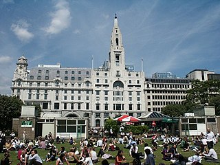
The Barbican Estate, or Barbican, is a residential complex of around 2,000 flats, maisonettes, and houses in central London, England, within the City of London. It is in an area once devastated by World War II bombings and densely populated by financial institutions, 1.4 miles north east of Charing Cross. Originally built as rental housing for middle and upper-middle-class professionals, it remains an upmarket residential estate. It contains, or is adjacent to, the Barbican Arts Centre, the Museum of London, the Guildhall School of Music and Drama, the Barbican public library, the City of London School for Girls and a YMCA, forming the Barbican Complex.

<span class="mw-page-title-main">Aldgate</span> Human settlement in England

Aldgate was a gate in the former defensive wall around the City of London. It gives its name to Aldgate High Street, the first stretch of the A11 road, which included the site of the former gate.

<span class="mw-page-title-main">City of London Corporation</span> English municipal governing body

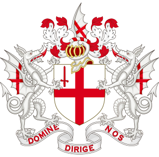
The City of London Corporation, officially and legally the Mayor and Commonalty and Citizens of the City of London, is the municipal governing body of the City of London, the historic centre of London and the location of much of the United Kingdom's financial sector.

Farringdon is a small district in Central London, the southern part of the London Borough of Islington. The term is used to describe the area around Farringdon station. Historically the district corresponded to southern Clerkenwell and the small parish of St Sepulchre Middlesex.

<span class="mw-page-title-main">London Wall</span> Defensive wall built around London

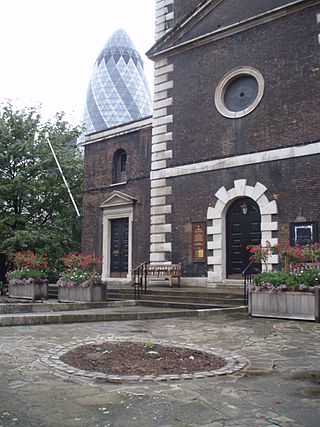
The London Wall is a defensive wall first built by the Romans around the strategically important port town of Londinium in c. AD 200, as well as the name of a modern street in the City of London, England.

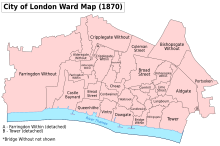
Aldersgate is a Ward of the City of London, England, named after one of the northern gates in the London Wall which once enclosed the City.

<span class="mw-page-title-main">Cities of London and Westminster (UK Parliament constituency)</span> UK Parliament constituency in England, created 1950

Cities of London and Westminster is a constituency returning a single Member of Parliament (MP) to the House of Commons in the United Kingdom Parliament. It is a borough constituency for the purposes of election expenses and type of returning officer. As with all constituencies, the election is decided using the first past the post system of election. Since its creation at the 1950 general election, the constituency has always elected the candidate nominated by the Conservative Party.

<span class="mw-page-title-main">Bassishaw</span> Ward of the City of London

Bassishaw is a ward in the City of London. Small, it is bounded by wards: Coleman Street, east; Cheap, south; Cripplegate, north; Aldersgate, west.

<span class="mw-page-title-main">Farringdon Within</span> Ward of the City of London

Farringdon Within is one of the 25 wards of the City of London, the historic and financial centre of London, England. It was formed in the 14th century from the sub-division of the pre-existing Farringdon Ward into Farringdon Within, and Farringdon Without, beyond the Wall.

<span class="mw-page-title-main">Farringdon Without</span> Ward of the City of London

Farringdon Without is the most westerly Ward of the City of London, England. Its suffix Without reflects its origin as lying beyond the City's former defensive walls. It was first established in 1394 to administer the suburbs west of Ludgate and Newgate, including West Smithfield and Temple. This was achieved by splitting the very large, pre-existing Farringdon Ward into two parts, Farringdon Within and Farringdon Without. The large and prosperous extramural suburb of Farringdon Without has been described as having been London's first West End.

<span class="mw-page-title-main">Portsoken</span> Ward of the City of London

Portsoken, traditionally referred to with the definite article as the Portsoken, is one of the City of London, England's 25 ancient wards, which are still used for local elections. Historically an extra-mural Ward, lying east of Aldgate and the City walls, the area is sometimes considered to be part of the East End of London.

<span class="mw-page-title-main">Cheap (ward)</span> Ward of the City of London

Cheap is a small ward in the City of London, England. It stretches west to east from King Edward Street, the border with Farringdon Within ward, to Old Jewry, which adjoins Walbrook; and north to south from Gresham Street, the border with Aldersgate and Bassishaw wards, to Cheapside, the boundary with Cordwainer and Bread Street wards. The name Cheap derives from the Old English word "chep" for "market".

<span class="mw-page-title-main">Coleman Street Ward</span> Ward of the City of London

Coleman Street is one of the 25 ancient wards of the City of London, England, and lies on the City's northern boundary with the London Borough of Islington.

<span class="mw-page-title-main">Castle Baynard</span> Ward of the City of London

Castle Baynard is one of the 25 wards of the City of London, the historic and financial centre of London, England.

<span class="mw-page-title-main">Wards of the City of London</span> Special form of ward in the City of London

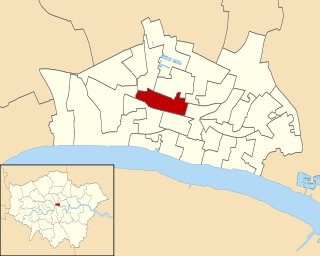
The City of London is divided into 25 wards. The city is the historic core of the much wider metropolis of Greater London, with an ancient and sui generis form of local government, which avoided the many local government reforms elsewhere in the country in the 19th and 20th centuries. Unlike other modern English local authorities, the City of London Corporation has two council bodies: the now largely ceremonial Court of Aldermen, and the Court of Common Council.

<span class="mw-page-title-main">Whitecross Street</span>

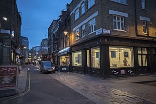
Whitecross Street is a short street in Islington, in Inner London. It features an eponymous street market and a large housing estate.

<span class="mw-page-title-main">2017 City of London Corporation election</span> Elections to the Court of Common Council of the City of London Corporation on 22 March 2017

The 2017 City of London Corporation election took place on 23 March 2017 to elect members of the Court of Common Council in the City of London Corporation. The election was the first time apart from a 2014 by-election that partisan candidates were elected to the body. Fifteen of the hundred seats on the council were won by political parties: the newly created Temple & Farringdon Together party and the Labour Party.

<span class="mw-page-title-main">2022 City of London Corporation election</span> 2022 local election in the City of London

The 2022 City of London Corporation election took place on 24 March 2022 to elect members of the Court of Common Council in the City of London Corporation, England. The election was postponed for a year due to the COVID-19 pandemic.

References

  1. "City of London Ward population 2011". Neighbourhood Statistics. Office for National Statistics. Archived from the original on 21 October 2016. Retrieved 16 October 2016.
  2. Cripplegate Ward News Archived 12 June 2011 at the Wayback Machine - note use of "Within" and "Without" on page 4
  3. Harben, Henry (1918). A Dictionary of London. London.{{cite book}}: CS1 maint: location missing publisher (link)
  4. 'Saxon London', by Alan Vince, 1990, p43
  5. 'Cripplegate, one of the 26 Wards of the City of London' Baddesley, J.J p91: London; Blades, East & Blades; 1921
  6. "London Wall: the west gate of Cripplegate fort and a section of Roman wall in London Wall underground car park, adjacent to Noble Street". historicengland.org.uk. Retrieved 4 March 2021.
  7. 1 2 3 4 5 Caroline Fiona Gordon (1985), The Ward of Cripplegate in the City of London, London: Cripplegate Ward Club, OL   14531369M
  8. A-Z London. Geographer's A-Z Map Co Ltd. 2001. p. 162. ISBN   0-85039-753-7.
  9. London 800-1216: The Shaping of a City, Brook and Keir Ch 7
  10. Archaeological Excavations at Moor House, Jeremy Haslam p48
  11. Light for the last days (1888), H. Grattan Guinness D.D., FRAS>
  12. Herbert, William, The History of the Twelve Great Livery Companies of London (London, Wm Herbert, 1836) pp. 80-81 at books.google.co.uk
  13. Tom Bolton (24 June 2015). "From Cripplegate to Agar Town: inside London's vanished neighbourhoods". The Guardian. Retrieved 24 June 2015. by the second world war, Cripplegate had become "Fire Island", the highest-insurance-risk area in London, occupied by rag trade warehouses packed with tinder-box stock.
  14. "A London Inheritance". A London Inheritance.
  15. "Black's Guide to Edinburgh". A. and C. Black. 1903.
  16. Whitaker, Joseph (1848). "An Almanack for the Year of Our Lord".
  17. "Find Member". democracy.cityoflondon.gov.uk. 6 March 2022.
  18. "Archived copy" (PDF). Archived from the original (PDF) on 9 November 2017. Retrieved 7 January 2019.{{cite web}}: CS1 maint: archived copy as title (link)
  19. "Labour wins record five seats in historic City of London election victory". The Independent. 24 March 2017.
  20. "Introducing Cripplegate Foundation". Cripplegate Foundation. Retrieved 7 June 2023.
  21. "Grants & Programmes". Cripplegate Foundation. Retrieved 7 June 2023.
  22. "HOW NOT WHAT". HOW NOT WHAT. Retrieved 7 June 2023.
  23. "More than just grant-making". Cripplegate Foundation. Retrieved 7 June 2023.[ permanent dead link ]
  24. 1 2 3 4 "History". www.cripplegate.org. Cripplegate Foundation Limited. Archived from the original on 9 December 2017. Retrieved 8 December 2017.
  25. "CRIPPLEGATE INSTITUTE, Non Civil Parish - 1262632 | Historic England". historicengland.org.uk.
  26. "London, Commercial & Cripplegate Bank Ltd". RBS Heritage Hub. Retrieved 5 June 2019.
  27. "The Discovery Service".
  28. Sic : Cripplegate is in the EC3 postcode area.
  29. Four Weddings and a Funeral Archived 18 April 2008 at the Wayback Machine at movie-locations.com