Langbourn

Last updated

Ward of Langbourn
City of London, Ward of Langbourn.svg
Location within the City
Greater London UK location map 2.svg
Red pog.svg
Ward of Langbourn
Location within Greater London
OS grid reference TQ331809
Sui generis
Administrative area Greater London
Region
Country England
Sovereign state United Kingdom
Post town LONDON
Postcode district EC3
Dialling code 020
Police City of London
Fire London
Ambulance London
UK Parliament
London Assembly
List of places
UK
England
London
51°30′43″N0°05′06″W / 51.512°N 0.085°W / 51.512; -0.085 Coordinates: 51°30′43″N0°05′06″W / 51.512°N 0.085°W / 51.512; -0.085

Langbourn is one of the 25 ancient wards of the City of London. It reputedly is named after a buried stream in the vicinity. [1]

Contents

St. Edmund's on Lombard Street. Lombard Street, London.jpg
St. Edmund's on Lombard Street.
St. Mary Woolnoth on the corner of Lombard Street and King William Street. St mary woolnoth exterior.jpg
St. Mary Woolnoth on the corner of Lombard Street and King William Street.

It is a small ward; a long thin area, running in a west–east direction. Historically, Lombard Street and Fenchurch Street were the principal streets, forming the cores of the ward's West and East divisions respectively. Boundary changes in 2003 and 2013 have resulted in most of the northern sides of these streets remaining in Langbourn, whilst the southern sides are now largely in the wards of Candlewick, Bridge, Billingsgate and Tower. Three changes to the boundaries of Langbourn took place in 2013; all of the southern side of Lombard Street, with the notable exception of the guild - or ward - church of St Mary Woolnoth, is in Candlewick (from 2003 to 2013 Candlewick extended only to Abchurch Lane); the ward of Walbrook now includes the northern side of Lombard Street from number 68 to Bank junction. In turn, Langbourn expanded by taking another part of Leadenhall Market, from Lime Street ward.

The ward at present borders eight other wards (Walbrook, Candlewick, Bridge, Billingsgate, Tower, Aldgate, Lime Street, and Cornhill); historically no other City ward bordered so many neighbours. [2]

The ward encompasses a large area of Leadenhall Market [3] and two historic churches: St. Mary Woolnoth and St. Edmund's. Historically, the ward also contained four other churches: St Nicholas Acons (destroyed in the Great Fire 1666), All Hallows Staining (demolished 1870), St. Dionis Backchurch (1878), and All Hallows Lombard Street (1939). [4] It has its own club for ward officials, City workers and residents [5] and newsletter. [6]

Politics

Langbourn is one of 25 wards of the City of London, electing an alderman to the Court of Aldermen and three councilmen (the City equivalent of a councillor) to the Court of Common Council of the City of London Corporation. Only electors who are a freeman of the City of London are eligible to stand.

Lost River

The 1598 Survey of London [7] records the course of the Langbourn river. The entry notes that the Langbourne had ceased to flow by the time the entry was written.

"Langborne water so called of the length thereof, was a greate streame of water breaking out of the ground, in Fan Church streete [Fenchurch St], which ran downe with a swift course, west, through that streete, thwart Grastreet [Gracechurch Street] and downe Lombardestreete [Lombard Street], to the west ende of S. Mary Woolnothes Church, and then turning the course South downe Shareborne lane [Sherbourne Lane], so termed of sharing or deviding, it brake into divers rilles or rillets to the River of Thames, of this Bourne that warde tooke the name, and is till this day called Langborne warde, this Bourne also is long since stopped up at the heade and the rest of the course filled up and paved over, so that no signe thereof remaineth more then the names aforesaide."

The John Stowe's 1598 Survey of London records the street name Sharebourne Lane and attributes its origin to the dividing of the stream at this point. Henry Harben's 1918 Dictionary of London [8] asserts that Stowe's explanation "must be left out of account as a possible derivation, inasmuch as it ignores the earliest forms of the name to be found." It goes on to list "Shitteborwelane," "Shiteburn lane," "Shiteb(ur)uelane" and "Shiteburlane as forms of the name recorded around 1300 AD. Harben goes on to state that:

"The first syllable " shitte," " shite," "schite," presents considerable difficulty, and it is hard to See from what A.S. [Anglo Saxon] word it can be derived, as the suggested derivation from A. S. "scir "= a share, "sciran "= to divide, seems to leave the "t" out of account. The word "borwe," "borue" suggests O.E. "burh," "burgh," "borough," rather than "burn" or "bourne," as the original form. "Burgh "= fortress, walled town, later perhaps "a mansion," "fortified house."

Later commentators [9] have made the conclusion that the modern english translation is either "Shit House Lane" or "Shite Bourne Lane" and refers to public latrines that were placed over the river.

Nicholas Barton, in his 1962 book "Lost Rivers of London" [10] lists the Langbourn in his chapter on "Dubious Lost Rivers" for three reasons:

  1. "It does not fit in with the contours, and actually involves the proposed stream's flowing uphill to the extent of three feet, both in the ancient and modern ground levels."
  2. "During the construction of the Gracechurch Street sewer the builders specifically looked for it and found no traces."
  3. "Stow more or less admits that he himself has nothing more to go on than the name."

Related Research Articles

<span class="mw-page-title-main">Subterranean rivers of London</span> Underground rivers in London, England

The subterranean or underground rivers of London are or were the direct or indirect tributaries of the upper estuary of the Thames, that were built over during the growth of the metropolis of London. They now flow through culverts, with some of them now integral parts of London's sewerage system and diverted accordingly.

<span class="mw-page-title-main">Aldgate</span> Human settlement in England

Aldgate was a gate in the former defensive wall around the City of London. It gives its name to Aldgate High Street, the first stretch of the A11 road, which included the site of the former gate.

<span class="mw-page-title-main">Gracechurch Street</span>

Gracechurch Street is a main road in the City of London, the historic and financial centre of London, which is designated the A1213.

<span class="mw-page-title-main">Billingsgate</span> Ward of the City of London

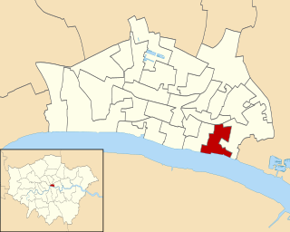
Billingsgate is one of the 25 Wards of the City of London. This small City Ward is situated on the north bank of the River Thames between London Bridge and Tower Bridge in the south-east of the Square Mile.

<span class="mw-page-title-main">St Mary Woolnoth</span> Church in London, England

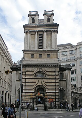
St Mary Woolnoth is an Anglican church in the City of London, located on the corner of Lombard Street and King William Street near Bank junction. The present building is one of the Queen Anne Churches, designed by Nicholas Hawksmoor. The parish church continues to be actively used for services, with Holy Communion every Tuesday. St Mary Woolnoth lies in the ward of Langbourn.

The Langbourne or Lorteburn is reputed to be a lost river, which may have run in the east of the City of London and gave its name to the Langbourn ward of the city. If it existed, the Langbourne was a small stream or streams, arising in the vicinity of Aldgate and either joining the Walbrook or flowing directly into the Thames. The river is seldom included on maps or lists of lost rivers, and its existence is denied by Nicholas Barton, in his 1962 book Lost Rivers of London, but in more recent work David Bentley argues for its existence.

<span class="mw-page-title-main">Fenchurch Street</span>

Fenchurch Street is a street in London linking Aldgate at its eastern end with Lombard Street and Gracechurch Street in the west. It is a well-known thoroughfare in the City of London financial district and is the site of many corporate offices and headquarters. The name "Fenchurch" means "church in the fenny or marshy ground" and presumably refers to St Gabriel Fenchurch, which stood at the junction of Fenchurch Street and Cullum Street until it was destroyed by the Great Fire.

<span class="mw-page-title-main">River Walbrook</span> Subterranean river in the City of London, England

The Walbrook is a subterranean river in London. It gives its name to the Walbrook City ward and to a nearby street. It played an important role in the Roman settlement of Londinium.

<span class="mw-page-title-main">St Edmund, King and Martyr</span> Church in London , England

St Edmund, King and Martyr, is an Anglican church in Lombard Street, in the City of London, dedicated to St Edmund the Martyr.

<span class="mw-page-title-main">St Benet Gracechurch</span> Church in London, England

St Benet Gracechurch, so called because a haymarket existed nearby (Cobb), was a parish church in the City of London. First recorded in the 11th century, it was destroyed in the Great Fire of London of 1666 and rebuilt by the office of Sir Christopher Wren. The church was demolished in 1868.

<span class="mw-page-title-main">Worshipful Company of Parish Clerks</span> Guild of the City of London

The Worshipful Company of Parish Clerks is one of the Guilds of the City of London. It has no livery, because "in the 16th century, the Parish Clerks declined to take the Livery on the grounds that the surplice was older than the Livery and was the proper garb of members of the Company." It is not, therefore, technically a livery company although to all intents and purposes it acts as such. It is one of two such historic companies without livery, the other being the Company of Watermen and Lightermen.

<span class="mw-page-title-main">St Nicholas Acons</span> Church in London, England

St Nicholas Acons was a parish church in the City of London. In existence by the late 11th century, it was destroyed during the Great Fire of London of 1666 and not rebuilt.

<span class="mw-page-title-main">Candlewick (ward)</span> Ward in the City of London

Candlewick is a small ward, one of the 25 ancient wards in the City of London.

<span class="mw-page-title-main">All Hallows Lombard Street</span> Church in London, England

All Hallows Lombard Street, also seen with descriptor Gracechurch Street, was a parish church in the City of London. It stood behind thin buildings fronting both streets, in Langbourn Ward, The west and south sides faced into Ball Alley. Of medieval origin, it was rebuilt following the Great Fire of London. It was demolished in 1937; its tower was reconstructed at Twickenham as part of the new church of All Hallows, which also received its bells and complete interior fittings.

<span class="mw-page-title-main">St Dionis Backchurch</span> Church in London, England

St Dionis Backchurch was a parish church in the Langbourn ward of the City of London. Of medieval origin, it was rebuilt after the Great Fire of London to the designs of Christopher Wren and demolished in 1878.

<span class="mw-page-title-main">St Mary Woolchurch Haw</span> Church in London, England

St Mary Woolchurch Haw was a parish church in the City of London, destroyed in the Great Fire of London of 1666 and not rebuilt. It came within the ward of Walbrook.

<span class="mw-page-title-main">St Leonard, Eastcheap</span> Church in London, England

St. Leonard, Eastcheap, sometimes referred to as St Leonard Milkchurch, was a parish church in the City of London. Of medieval origin, it was destroyed in the Great Fire of London in 1666 and not rebuilt. The site of the church was retained as a graveyard.

<span class="mw-page-title-main">Lombard Street, London</span>

Lombard Street is a street notable for its connections with the City of London's merchant, banking and insurance industries, stretching back to medieval times.

<span class="mw-page-title-main">Bank Junction</span>

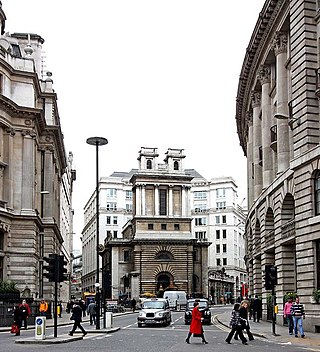
Bank Junction is a major road junction in the City of London, the historic and financial centre of London, at which nine streets converge and where traffic is controlled by traffic lights and give-way lines. It is named after the nearby Bank of England. Directly underneath it is one of the ticket halls of Bank station, one of the busiest stations on the London Underground.

References

  1. Derivation of name
  2. The City of London-a history Borer,M.I.C. (New York,D.McKay Co, 1978) ISBN   0-09-461880-1
  3. City of London Police Profile Archived 9 October 2007 at the Wayback Machine
  4. Vanished Churches of the City of London Huelin,G: London (Guildhall Publishing, 1996) ISBN   0-900422-42-4
  5. Ward Club details Archived 24 July 2008 at the Wayback Machine
  6. 7 March edition [ permanent dead link ]
  7. Stow, John; Stephen, William fitz (2016). "Survey of London (1598): Rivers and Other Waters". mapoflondon.uvic.ca. Retrieved 19 September 2021.
  8. "Shelley House - Ship Alley | British History Online". www.british-history.ac.uk. Retrieved 19 September 2021.
  9. Partridge, Chris (18 April 2004). "A street by any other name..." the Guardian. Retrieved 19 September 2021.
  10. Barton, Nicholas (1962). Lost Rivers of London. Historical Publications Ltd. p. 60. ISBN   9780948667152.