Aldgate Pump

Last updated

The Aldgate Pump, looking east towards Whitechapel prior to August 2019 restoration. Aldgate Pump (33081127203).jpg
The Aldgate Pump, looking east towards Whitechapel prior to August 2019 restoration.

Aldgate Pump is a historic former water pump located at the junction where Aldgate High Street meets Fenchurch Street and Leadenhall Street in the City of London. The pump is considered to be the symbolic start point of the East End of London.

Contents

The pump is also notable for its long and sometimes dark history, along with its significant cultural references.

Design

The wolf's head on Aldgate Pump The wolf of Aldgate pump (39035980574).jpg
The wolf's head on Aldgate Pump

Aldgate Pump is a Grade II listed structure. [1] The metal wolf head on the pump's spout is supposed to signify the last wolf shot in the City of London. [2]

Historic photographs show that the pump was surmounted by an ornate wrought iron lantern. During the 20th century this was removed, but was recreated by the Bottega Prata workshop in Bologna, Italy, during its restoration by the Heritage of London Trust, unveiled in September 2019. [3] The pump can no longer be used to draw water, but a drainage grating is still in place.

History

As a well, it was mentioned during the reign of King John in the early 13th century. [4]

A structure is shown on Braun and Hogenburg's map of 1574, and shown as St Michael’s Well on the Agas map of 1633. John Stow recalled the execution of the Bailiff of Romford on a gibbet 'near the well within Aldgate'. [5] This execution seems to have been carried out on the dubious basis that he was involved in Kett's Rebellion of 1549. [6]

The pump in 1874 The Aldgate Pump in 1874. Wellcome M0010341.jpg
The pump in 1874

Served by one of London's many underground streams, the water was praised for being "bright, sparkling, and cool, and of an agreeable taste". [7] These qualities were later found to be derived from decaying organic matter from adjoining graveyards, [7] and the leaching of calcium from the bones of the dead in many new cemeteries in north London through which the stream ran from Hampstead. [8] Several hundred people died during what became known as the Aldgate Pump Epidemic, [8] [ dubious ] and on its relocation in 1876, the New River Company changed the supplies to mains water.

Fenchurch Street railway station was built in 1841 upon the site of Aldgate Pump Court. [9]

As the City of London developed, it is thought to have been taken down and moved a short distance to the west, to its current location in 1876, as a result of road widening. [4]

East End

The pump has been at its current site since 1876 Aldgate Pump - geograph.org.uk - 498941.jpg
The pump has been at its current site since 1876

The line of the former eastern walls and gates of the City are taken as the usual start point of the East End, but the pump lies just inside the site of the former Aldgate. The pump is a suitable symbolic start point for several reasons:

Cultural references

Phrases

East of Aldgate Pump is a term used to apply to the East End or East London as a whole. It is also used in two phrases which seem to hark back to the epidemic:

Music, TV and literature

Charles Dickens refers to the pump in The Uncommercial Traveller , published in 1860: "My day's no-business beckoning me to the East End of London. I had turned my face to that point of the metropolitan compass…and had got past Aldgate Pump." [11]

Aldgate Pump was also the name of a song, written by G. W. Hunt for the lion comique Arthur Lloyd in 1869. In the song, the raconteur is abandoned by the girl "I met near Aldgate Pump". [12]

Not without hyperbole, the pump was once referenced thus: "East of Aldgate Pump, people cared for nothing but drink, vice and crime". [13]

Related Research Articles

<span class="mw-page-title-main">City of London</span> Central business district of the Greater London Conurbation, England

The City of London, widely referred to simply as the City, is a city, ceremonial county and local government district that contains the ancient centre, and constitutes, along with Canary Wharf, the primary central business district (CBD) of London and one of the leading financial centres of the world. It constituted most of London from its settlement by the Romans in the 1st century AD to the Middle Ages, but the modern area referred to as London has since grown far beyond the City of London boundary. The City is now only a small part of the metropolis of Greater London, though it remains a notable part of central London. The City of London is not one of the London boroughs, a status reserved for the other 32 districts. It is also a separate ceremonial county, being an enclave surrounded by Greater London, and is the smallest ceremonial county in England.

<span class="mw-page-title-main">Whitechapel</span> Human settlement in England

Whitechapel is an area in London, England, and is located in the London Borough of Tower Hamlets. It is in East London and part of the East End. It is the location of Tower Hamlets Town Hall and therefore the borough town centre. Whitechapel is located 3.4 miles (5.5 km) east of Charing Cross.

<span class="mw-page-title-main">London Borough of Barking and Dagenham</span> London borough in United Kingdom

The London Borough of Barking and Dagenham is a London borough in East London. It lies around 9 miles (14.4 km) east of Central London. It is an Outer London borough and the south is within the London Riverside section of the Thames Gateway; an area designated as a national priority for urban regeneration. At the 2011 census it had a population of 187,000, the majority of which are within the Becontree estate. The borough's three main towns are Barking, Chadwell Heath and Dagenham. The local authority is the Barking and Dagenham London Borough Council. Barking and Dagenham was one of six London boroughs to host the 2012 Summer Olympics.

<span class="mw-page-title-main">Aldgate</span> Human settlement in England

Aldgate was a gate in the former defensive wall around the City of London.

<span class="mw-page-title-main">Fenchurch Street railway station</span> Railway terminus in the City of London

Fenchurch Street railway station, also known as London Fenchurch Street, is a central London railway terminus in the southeastern corner of the City of London. It takes its name from its proximity to Fenchurch Street, a key thoroughfare in the City. The station and all trains are operated by c2c. Services run on lines built by the London and Blackwall Railway (L&BR) and the London, Tilbury and Southend Railway (LTSR) are to destinations in east London and south Essex, including Upminster, Grays, Basildon, Southend and Shoeburyness.

<span class="mw-page-title-main">Tower Hill tube station</span> London Underground station

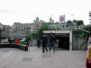
Tower Hill is a London Underground station in Tower Hill in the East End of London. It is on the Circle line between Monument and Aldgate stations, and the District line between Monument and Aldgate East. Tower Hill is within Travelcard zone 1 and is a short distance from Tower Gateway station for the Docklands Light Railway, Fenchurch Street station for National Rail mainline services, and Tower Millennium Pier for River Services.

<span class="mw-page-title-main">Aldgate tube station</span> London Underground station

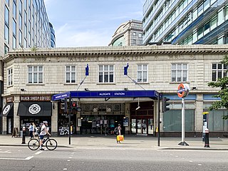
Aldgate is a London Underground station near Aldgate in the City of London. The station is on the Circle line between Tower Hill and Liverpool Street, and is the eastern terminus of the Metropolitan line. It is in Travelcard Zone 1.

<span class="mw-page-title-main">A11 road (England)</span> Road in England

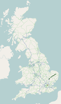
The A11 is a major trunk road in England. It originally ran roughly north east from London to Norwich, Norfolk. It now consists of a short section in Inner London and a much longer section in Cambridgeshire, Suffolk and Norfolk. The lengthy section between these was renumbered as a result of the opening of the M11 in the 1970s and then the A12 extension in 1999.

<span class="mw-page-title-main">Upminster station</span> London Underground and railway station

Upminster is an interchange station serving the town of Upminster in the London Borough of Havering, Greater London. It is on the London, Tilbury and Southend line (LTSR), 15 miles 20 chains (24.5 km) down the line from London Fenchurch Street; it is the eastern terminus of the District line on the London Underground; and it is the eastern terminus of the Romford to Upminster Line on the London Overground network. Upminster is the easternmost station on the London Underground network as well as the easternmost National Rail station in London.

<span class="mw-page-title-main">London, Tilbury and Southend line</span> Commuter railway line in Essex, England

The London, Tilbury and Southend line, also known as Essex Thameside, is a commuter railway line on the British railway system. It connects Fenchurch Street station, in central London, with destinations in east London and Essex, including Barking, Upminster, Basildon, Grays, Tilbury, Southend and Shoeburyness.

<span class="mw-page-title-main">St Olave's Church, Hart Street</span> Church in London, England

St Olave's Church, Hart Street, is a Church of England church in the City of London, located on the corner of Hart Street and Seething Lane near Fenchurch Street railway station.

<span class="mw-page-title-main">Bow, London</span> Human settlement in England

Bow is an area of east London, England, within the London Borough of Tower Hamlets, 4.6 miles (7.4 km) east of Charing Cross.

<span class="mw-page-title-main">Fenchurch Street</span> Street in the City of London

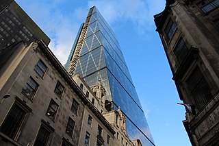
Fenchurch Street is a street in London, England, linking Aldgate at its eastern end with Lombard Street and Gracechurch Street in the west. It is a well-known thoroughfare in the City of London financial district and is the site of many corporate offices and headquarters. The name "Fenchurch" means "church in the fenny or marshy ground" and presumably refers to St Gabriel Fenchurch, which stood at the junction of Fenchurch Street and Cullum Street until it was destroyed by the Great Fire.

<span class="mw-page-title-main">Leadenhall Street</span> Street in the City of London, England

Leadenhall Street is a street in the City of London. It is about 13-mile-long (0.54 km) and links Cornhill in the west to Aldgate in the east. It was formerly the start of the A11 road from London to Norwich, but that route now starts further east at Aldgate.

<span class="mw-page-title-main">Horsemonger Lane Gaol</span> Prison in south London (closed 1878)

Horsemonger Lane Gaol was a prison close to present-day Newington Causeway in Southwark, south London. Built at the end of the 18th century, it was in use until 1878.

<span class="mw-page-title-main">East Tilbury</span> Village in Essex, England

East Tilbury is a village and former civil parish in the unitary authority of Thurrock borough, Essex, England, and one of the traditional Church of England parishes in Thurrock. In 2011 the ward had a population of 6,363.

<span class="mw-page-title-main">Lime Street, London</span>

Lime Street is a minor road in the City of London between Fenchurch Street to the south and Leadenhall Street to the north. Its name comes from the lime burners who once sold lime from there for use in construction.

<span class="mw-page-title-main">Langbourn</span> Ward of the City of London

Langbourn is one of the 25 ancient wards of the City of London. It reputedly is named after a buried stream in the vicinity.

<span class="mw-page-title-main">East End of London</span> Area of London, England

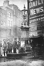
The East End of London, often referred to within the London area simply as the East End, is the historic core of wider East London, east of the Roman and medieval walls of the City of London and north of the River Thames. It does not have universally accepted boundaries on its north and east sides, though the River Lea is sometimes seen as the eastern boundary. Parts of it may be regarded as lying within Central London. The term "East of Aldgate Pump" is sometimes used as a synonym for the area.

<span class="mw-page-title-main">East India Arms</span> Pub in London, England

The East India Arms is a pub in the City of London. The building is located on Fenchurch Street near the place where the East India Company had its headquarters.

References

  1. Historic England. "Details from listed building database (1064733)". National Heritage List for England . Retrieved 14 September 2009.
  2. "The English-speaking World: Incorporating the Landmark". English-Speaking Union. 29 April 1932. Archived from the original on 22 May 2022. Retrieved 21 September 2020 via Google Books.
  3. https://memoirsofametrogirl.com/2022/06/09/aldgate-water-pump-history-city-of-london/
  4. 1 2 Aldermary Churchyard – Aldgate Ward Archived 4 June 2011 at the Wayback Machine , A Dictionary of London (1918). accessed 14 September 2009
  5. 1 2 The London Encyclopaedia, Weinreb and Hibbert
  6. Romford Recorder article looking at the execution https://www.romfordrecorder.co.uk/news/heritage/romford-history-shock-as-bailiff-was-hanged-under-martial-law-1-5116417 Archived 2 August 2019 at the Wayback Machine
  7. 1 2 Britain), Institution of Civil Engineers (Great (29 April 1868). "Minutes of Proceedings of the Institution of Civil Engineers". The Institution. Archived from the original on 22 May 2022. Retrieved 21 September 2020 via Google Books.
  8. 1 2 "Aldgate Pump. Part of the Secret London series by Historic UK". Historic UK. Archived from the original on 24 September 2020. Retrieved 29 April 2019.
  9. Aldgate Ward School – All Hallows Garschirch, Gracechurch, Grascherch, in Gracioustreete Archived 19 August 2011 at the Wayback Machine , A Dictionary of London (1918). accessed 14 September 2009
  10. Brewers dictionary of phrase and fable ) https://www.bartleby.com/81/5319.html Archived 2 August 2019 at the Wayback Machine
  11. Charles Dickens, The Uncommercial Traveller, Chapter 3, "Wapping Workhouse".
  12. Arthur Lloyd's "Aldgate pump" Archived 7 September 2008 at the Wayback Machine (Arthur Lloyd music hall history) accessed 14 September 2009
  13. Hoping to find the original source http://spitalfieldslife.com/2019/07/11/at-aldgate-pump/ Archived 12 July 2019 at the Wayback Machine

51°30′47.4″N00°04′40.4″W / 51.513167°N 0.077889°W / 51.513167; -0.077889