
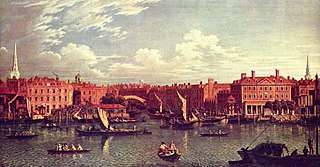
Blackfriars Bridge is a road and foot traffic bridge over the River Thames in London, between Waterloo Bridge and Blackfriars Railway Bridge, carrying the A201 road. The north end is in the City of London near the Inns of Court and Temple Church, along with Blackfriars station. The south end is in the London Borough of Southwark, near the Tate Modern art gallery and the Oxo Tower.

Thameslink is a 24-hour main-line route in the British railway system, running from Bedford, Luton, St Albans City, Peterborough and Cambridge via central London to Sutton, Orpington, Sevenoaks, Rainham, Horsham, Brighton, East Grinstead, and Littlehampton. The network opened as a through service in 1988, with severe overcrowding by 1998, carrying more than 28,000 passengers in the morning peak. All the services are currently operated by Govia Thameslink Railway.
The River Fleet is the largest of London's subterranean rivers, all of which today contain foul water for treatment. It has been used as a sewer since the development of Joseph Bazalgette's London sewer system in the mid 19th century with the water being treated at Beckton Sewage Treatment Works. Its headwaters are two streams on Hampstead Heath, each of which was dammed into a series of ponds—the Hampstead Ponds and the Highgate Ponds—in the 18th century. At the southern edge of Hampstead Heath these descend underground as sewers and join in Camden Town. The waters flow 4 miles (6 km) from the ponds.

Blackfriars, also known as London Blackfriars, is a central London railway station and connected London Underground station in the City of London. It provides Thameslink services: local, and regional and limited Southeastern commuter services to South East London and Kent. Its platforms span the River Thames, the only one in London to do so, along the length of Blackfriars Railway Bridge, a short distance downstream from Blackfriars Bridge. There are two station entrances either side of the Thames, along with a connection to the London Underground District and Circle lines.

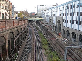
Snow Hill tunnel is a railway tunnel on the northern edge of the City of London which carries the up and down Snow Hill lines between City Thameslink and Farringdon stations. The tunnel runs beneath the Smithfield meat market and was constructed, using the cut-and-cover method, immediately prior to the building of the market. The tunnel opened on 1 January 1866.

Ludgate Hill is a street and surrounding area, on a small hill in the City of London, England. The street passes through the former site of Ludgate, a city gate that was demolished – along with a gaol attached to it – in 1760.

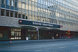
City Thameslink is a central London railway station within the City of London, with entrances on Ludgate Hill and Holborn Viaduct. The station is on the Thameslink route between Blackfriars to the south and Farringdon to the north.

Farringdon Road is a road in Clerkenwell, London.
Blackfriars is in central London, specifically the south-west corner of the City of London.
Holborn Viaduct was a railway station in the City of London, providing local and commuter services. It was located to the southeast of Holborn Viaduct, and east of Farringdon Street.
Rowland Mason Ordish was an English engineer. He is most noted for his design of the Winter Garden, Dublin (1865), for his detailed work on the single-span roof of London's St Pancras railway station, undertaken with William Henry Barlow (1868) and the Albert Bridge, a crossing of the River Thames in London, completed in 1873.

The London station group is a group of 18 railway stations served by the National Rail network in central London. The group contains all 14 terminal stations in central London, either serving major national services or local commuter routes, and 4 other through-stations that are considered terminals for ticketing purposes. All current stations in the group fall within London fare zone 1. A ticket marked "London Terminals" allows travel to any station in the group via any permitted route, as determined by the National Routeing Guide.

Ludgate Hill was a railway station in the City of London that was opened on 1 June 1865 by the London, Chatham and Dover Railway (LC&DR) as its City terminus. It was on Ludgate Viaduct between Queen Victoria Street and Ludgate Hill, slightly north of St. Paul's station on the site of the former Fleet Prison.

Ludgate Circus is a road junction in the City of London where Farringdon Street/New Bridge Street crosses Fleet Street/Ludgate Hill.
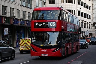
London Buses route 63 is a Transport for London contracted bus route in London, England. Running between Honor Oak and King's Cross, it is operated by Abellio London.

The Thameslink Programme, originally Thameslink 2000, was a £6 billion project in south-east England to upgrade and expand the Thameslink rail network to provide new and longer trains between a wider range of stations to the north and to the south of London. The development facilitated new cross-London journeys, which means that passengers no longer have to change trains in London. Work included platform lengthening, station remodelling, new railway infrastructure, and new rolling stock. The project was originally proposed in 1991 following the successful introduction of the initial Thameslink service in 1988. After many delays, planning permission was granted in 2006 and funding was approved in October 2007. Work started in 2009 and was completed on 18 September 2020, although trains over the new routes began running in 2018.
The Widened Lines is a double-track railway line forming part of the Thameslink route between St Pancras and Farringdon within Central London.

The A201 is an A road in London running from Kings Cross to Bricklayer's Arms.
Ludgate Circus was a planned London Underground station that would have formed part of "phase 2" of the Fleet line had it been completed. Taking its name from the nearby Ludgate Circus in the City of London financial district, preliminary preparation work was begun in the 1970s, but the plan was later postponed due to lack of funds.

The Holborn Viaduct–Herne Hill line is a railway line between Holborn Viaduct in the City of London and Herne Hill in the London Borough of Lambeth. After the closure of Holborn Viaduct station the line ends at the south portal of Snow Hill tunnel merging into Snow Hill lines. From there the Widened Lines to St Pancras and Kentish Town are reached. Today the section north of Blackfriars is part of the Thameslink core. Originally being a branch line of the London, Chatham and Dover Railway (LCDR) towards the City of London, the line is sometimes called LCDR City Branch.


