Geographical midpoint of Europe

Last updated

This map shows in red points some of the locations of claimants to the title of Centre of Europe:
Dilove (Rakhiv, Ukraine), Krahule (or Kremnicke Bane, Slovakia), Dresden and Kleinmaischeid (Germany), Torun and Suchowola (Poland), Bernotai, or Purnuskes (Lithuania)
.mw-parser-output .side-box{margin:4px 0;box-sizing:border-box;border:1px solid #aaa;font-size:88%;line-height:1.25em;background-color:#f9f9f9;display:flow-root}.mw-parser-output .side-box-abovebelow,.mw-parser-output .side-box-text{padding:0.25em 0.9em}.mw-parser-output .side-box-image{padding:2px 0 2px 0.9em;text-align:center}.mw-parser-output .side-box-imageright{padding:2px 0.9em 2px 0;text-align:center}@media(min-width:500px){.mw-parser-output .side-box-flex{display:flex;align-items:center}.mw-parser-output .side-box-text{flex:1}}@media(min-width:720px){.mw-parser-output .side-box{width:238px}.mw-parser-output .side-box-right{clear:right;float:right;margin-left:1em}.mw-parser-output .side-box-left{margin-right:1em}}
.mw-parser-output .plainlist ol,.mw-parser-output .plainlist ul{line-height:inherit;list-style:none;margin:0;padding:0}.mw-parser-output .plainlist ol li,.mw-parser-output .plainlist ul li{margin-bottom:0}
Map all coordinates using OpenStreetMap
Download coordinates as:
KML
GPX (all coordinates)
GPX (primary coordinates)
GPX (secondary coordinates) Centre of Europe.jpg
This map shows in red points some of the locations of claimants to the title of Centre of Europe:
Dilove (Rakhiv, Ukraine), Krahule (or Kremnické Bane, Slovakia), Dresden and Kleinmaischeid (Germany), Toruń and Suchowola (Poland), Bernotai, or Purnuškės (Lithuania)

The location of the geographical centre of Europe depends on the definition of the borders of Europe, mainly whether remote islands are included to define the extreme points of Europe, and on the method of calculating the final result. Thus, several places claim to host this hypothetical centre.

Contents

Current claimants

Locations currently vying for the distinction of being the centre of Europe include:

Extreme points of Europe

Extreme points of Europe and two of its geographic centres: the Saaremaa island in western Estonia, and Babruysk in Belarus. Extreme points of Europe.png
Extreme points of Europe and two of its geographic centres: the Saaremaa island in western Estonia, and Babruysk in Belarus.

The picture above shows the extreme points of Europe, northern or southern. The northern, which are Ostrov Rudolfa or Rudolf Island, a Russian island, Kinnarodden, a tourist attraction in Norway, and Mys Zhelaniya or Cape Zhelaniya, the northernmost point of Severny Island, Russia. The extreme southern parts of Europe are Cabo da Roca, A historical place in Portugal, Punta de Tarifa, the southernmost point on the Spanish mainland, and Gavdos, an island in Greece under the administrative region of Crete.

History of claims

Poland

Monument in Suchowola, Poland Podlaskie - Suchowola - Suchowola - Kosciuszki - Park - Kamien centrum Europy 20110925 01.JPG
Monument in Suchowola, Poland

The first official declaration of the Centre of Europe was made in 1775 by the Polish royal astronomer and cartographer Szymon Antoni Sobiekrajski, who calculated it to be in the town of Suchowola [9] near Białystok in modern north-eastern Poland. The method used was that of calculating equal distances from the extreme points of Europe: the westernmost point in Portugal; the easternmost point in the Central Urals; the northernmost point in Norway; and the southernmost point in Greece (islands were not taken into consideration). There is a monument commemorating that definition in Suchowola 53°34′39″N23°06′22″E / 53.57750°N 23.10611°E / 53.57750; 23.10611 (Suchowola, Poland (monument)) .

Slovakia

The marker stone in Kremnicke Bane, Slovakia KremnickeBane-stred-europy.jpg
The marker stone in Kremnické Bane, Slovakia

In about 1815 there was a declaration that the centre of Europe was located near the mining town of Kremnica, on a hill that forms the water division between the basins of the Baltic Sea and Black Sea, near St. John Baptist Church. The method used for calculating is unknown, but from the description given on the commemorative plaque located near the church 48°44′37″N18°55′50″E / 48.74361°N 18.93056°E / 48.74361; 18.93056 (Kremnické Bane, Slovakia (monument)) , it seems that it has been the centre of the smallest circle circumscribed on Europe (yet the limits of Europe taken into consideration are not known). The title of the "Centre of Europe" is also claimed by the neighbouring village Krahule (ancient Blaufuß), which used to belong to the same parish, now a famous centre for winter sports, with a hotel and recreation centre called "Stred Európy" ("Centre of Europe").

Transcarpathia, Ukraine

Austrian-Hungarian marker in Ukraine Center of Europe - monument - nearby Rakhiv - Ukraine (5647-49).jpg
Austrian-Hungarian marker in Ukraine

In 1887, geographers from the Austro-Hungarian Empire set up a historical marker and a large stone in what is today a part of Ukraine, believed to mark the geographic centre of Europe. The interpretation of the worn Latin inscription on the monument is debated, with some claiming that the marker is merely one of a number of fixed triangulation points for surveying purposes established around the territory of the former empire. The external borders of Europe taken into account during the calculations are not known. According to the description, the methodology used for the calculation is that of the geometrical middle point of the extreme latitudes and longitudes of Europe, so the stone was located at 48°30′N23°23′E / 48.500°N 23.383°E / 48.500; 23.383 . However, the actual location of the monument seems rather 47°57′46.47″N24°11′14.4″E / 47.9629083°N 24.187333°E / 47.9629083; 24.187333 (Dilove, Ukraine (monument)) and not the coordinates to which they relate. This is near the village of Dilove located on the Tisza river, close to the Romanian border, in the county of Rakhiv in the Transcarpathian region.

Soviet measurements

Measurements done after World War II by Soviet scientists reconfirmed the Austria-Hungarian claim that Rakhiv and Dilove to be the geographical centre of Europe. The old marker in the small town was renewed, and a major campaign to convince everyone of its validity was undertaken.[ citation needed ]

Tillenberg/Dyleň, today in the Czech Republic/Bavaria

Marker near Tillenberg Mittelpunkt Europas.jpg
Marker near Tillenberg

Austrian geographers also marked the 939-metre-high Tillenberg (Dyleň) near the Bohemian city of Eger/Cheb with a copper plate as the centre of Europe. As the border to Germany/Bavaria runs 100 m west of the mountaintop, the German village of Bad Neualbenreuth uses this for promotional purposes. Bayerischer Rundfunk journalists asked the Institut für Geographie of the University of Munich to verify the claims. The institute concluded that the centre lies further to the south, in Hildweinsreuth near Flossenbürg.

Sweden

In 1988 using Spherical trigonometry with the three corners of Europe as Cabo de São Vincente in the west, Spitsbergen in the north and Astrakan in the east, Arne Wennberg calculated Landskrona as the midpoint of Europe. [10] A monument is built on the town square in the form of a pen stuck in stone.

Lithuania

Monument in Girija, Lithuania CentreofEurope.jpg
Monument in Girija, Lithuania
The division of Europe into the cardinal directions and the central part (with an area of 1/9 of Europe) from the geographical center in Lithuania The division of Europe by cardinal directions.Center of Europe near Vilnius. Caucasus border.png
The division of Europe into the cardinal directions and the central part (with an area of 1/9 of Europe) from the geographical center in Lithuania

After a re-estimation of the boundaries of the continent of Europe in 1989, Jean-George Affholder, a scientist at the Institut Géographique National (French National Geographic Institute) determined that the geographic centre of Europe is located at 54°54′24″N25°19′12″E / 54.90667°N 25.32000°E / 54.90667; 25.32000 (Purnuškės (centre of gravity)) . [11] The method used for calculating this point was that of the centre of gravity of the geometrical figure of Europe. This point is located in Lithuania, near the village of Girija. A monument, composed by the sculptor Gediminas Jokūbonis and consisting of a column of white granite surmounted by a crown of stars, was erected at the location in 2004. An area of woods and fields surrounding the geographic centre point and including Lake Girija, Bernotai Hill, and an old burial ground, was set aside as a reserve in 1992. The State Tourism Department at the Ministry of Economy of Lithuania has classified the Geographic Centre monument and its reserve as a tourist attraction. 17 km away lies Europos Parkas, Open Air Museum of the Centre of Europe, a sculpture park containing the world's largest sculpture made of TV sets. [12]

It is the only Geographical Centre of Europe with recognition in the Guinness Book of World Records. [13]

Hungary

Church in Tallya Tallya legifoto1.jpg
Church in Tállya

It is claimed that a 1992 survey found that the geometric centre of Europe is in the village of Tállya, Hungary 48°14′10″N21°13′33″E / 48.23610°N 21.22574°E / 48.23610; 21.22574 . [14] [15] In 2000, a sculpture was erected in the village, with a table on it declaring the place the "Geometric Centre of Europe". [16]

Belarus

Monument to the Geographical Centre of Europe in Polotsk, Belarus Polotsk Centr Evropy 1.JPG
Monument to the Geographical Centre of Europe in Polotsk, Belarus

In 2000 Belarusian scientists Alexey Solomonov and Valery Anoshko published a report that stated the geographic centre of Europe was located near Lake Sho ( 55°10′55″N28°15′30″E / 55.18194°N 28.25833°E / 55.18194; 28.25833 ; Belarusian : Шо) in Vitebsk Region. [17]

The scientists used a special computer program that takes Europe in a single entity – the White Sea and the Baltic Sea, Britain and Ireland were included in the program as continental zone objects. It is assumed that in the calculations to determine the center of Europe, one must take into account the inland waters of Europe and the Ural Mountains, the eastern border of Europe.

Scientists from the Russian Central Research Institute of Geodesy, Aerial Survey and Cartography (Russian : ЦНИИГАиК) confirmed the calculations of Belarusian geodesists that the geographical centre of Europe is located in Polotsk 55°30′0″N28°48′0″E / 55.50000°N 28.80000°E / 55.50000; 28.80000 . A small monument to the Geographical Centre of Europe was set up in Polotsk on 31 May 2008. [18]

Estonia

Saaremaa island in western Estonia Eesti Saaremaa.png
Saaremaa island in western Estonia

It is claimed that if all the islands of Europe – from the Azores to Franz Joseph Land and from Crete to Iceland – are taken into consideration then the centre of Europe lies at 58°18′14″N22°16′44″E / 58.30389°N 22.27889°E / 58.30389; 22.27889 (North of Torgu) in the village of Mõnnuste, on Saaremaa island in western Estonia. Again, no author and no method of calculation have been disclosed. The local Kärla Parish is seeking to verify the location and to turn it into a tourist location. [19]

Geographic centre of the European Union

The French Institut Géographique National (IGN) has been calculating the changing location of what it estimates to be the geographical centre of the European Union (EU) since at least 1987. Its calculations exclude such extra-European territories of the EU as French Polynesia. As the European Union (or formerly – European Community) has grown in the last 50 years, the geographical centre has shifted with each expansion.

1987–1990

Church in Saint-Andre-le-Coq Eglise de Saint-Andre-le-Coq face sud.jpg
Church in Saint-André-le-Coq

12 members: In 1987 the centre of the European Community of the 12 members was declared to be in the middle of France, in the village of Saint-André-le-Coq, département of Puy-de-Dôme, région of Auvergne.

1990–1995

Village of Saint-Clement 003 St Clement ( 03250 ).JPG
Village of Saint-Clément

12 members after the reunification of Germany . In 1990, the centre shifted some 25 km north-eastward, to the place called Noireterre in the village of Saint-Clément, département of Allier, the same région of Auvergne. A small monument commemorating the latter discovery still exists in Saint Clément.

1995–2004

Memorial at Viroinval (15-member-EU) Centre europe des 15.jpg
Memorial at Viroinval (15-member-EU)

15 members: Using the same techniques, the IGN has identified the geographic centre of the 15-member Union (1995–2004) to be in Viroinval, Belgium, at coordinates 50°00′33″N4°39′59″E / 50.00917°N 4.66639°E / 50.00917; 4.66639 (Viroinval (15 members)) , and a monument there records that finding.

2004–2007

Memorial at Kleinmaischeid (25-member-EU) Kleinmaischeid Zirkelschlag.jpg
Memorial at Kleinmaischeid (25-member-EU)

25 members: The 25-member Union (2004–2007), had a centre calculated by the IGN to be situated at 50°31′31″N7°35′50″E / 50.52528°N 7.59722°E / 50.52528; 7.59722 (Kleinmaischeid (25 members)) , in the village of Kleinmaischeid, Rhineland-Palatinate, Germany.

2007–2013

Memorial at Gelnhausen-Meerholz (27-member-EU) Mittelpunkt Europas bei Gelnhausen-Meerholz.JPG
Memorial at Gelnhausen-Meerholz (27-member-EU)

27 members: On 1 January 2007, with the inclusion of Romania and Bulgaria in the European Union, the geographic centre of the European Union changed to a wheat field outside of the German town Gelnhausen, in the state of Hesse, 115 km east of the previous marker, at 50°10′21″N9°9′0″E / 50.17250°N 9.15000°E / 50.17250; 9.15000 (Gelnhausen (27 members)) . [20]

2013–2020

Geographical centre of the 28-member European Union including Mayotte (from 10 May 2014) in Westerngrund, Bavaria Mittelpunkt der EU seit 10. Mai 2014 in Westerngrund.JPG
Geographical centre of the 28-member European Union including Mayotte (from 10 May 2014) in Westerngrund, Bavaria

28 members: On 1 July 2013, with the accession of Croatia, the geographic centre entered North-West Bavaria in the place Westerngrund at the river Schulzengrundbach at 50°7′2.23″N9°14′51.97″E / 50.1172861°N 9.2477694°E / 50.1172861; 9.2477694 (Geographical Centre of EU in Westerngrund (28 members since 1 July 2013)) . When the French overseas department Mayotte (Indian Ocean island group between Southeast African mainland and Madagascar) joined the EU on 10 May 2014 (as part of France), the geographic center shifted by 500 m to 50°6′8.004″N9°15′15.91″E / 50.10222333°N 9.2544194°E / 50.10222333; 9.2544194 (Geographical Centre of EU in Westerngrund (28 members including Mayotte since 10 May 2014)) , still at Westerngrund, beside a path. [21] It is 40 km east of Frankfurt, Germany, which is headquarters to the European Central Bank.

2020–present

Gadheim, Bavaria GADHEIM-EU-CENTRE-OF-POST-BREXIT.jpg
Gadheim, Bavaria

27 members after Brexit : On 31 January 2020, with the withdrawal of the United Kingdom from the EU, the geographical mid-point moved to Gadheim near Würzburg, Bavaria, at 49°50′34.8″N9°54′07.4″E / 49.843000°N 9.902056°E / 49.843000; 9.902056 (geometric center of EU, post-Brexit) . [22]

Other calculations

The geographical midpoint of the European Union is not free from disputes either. If some different extreme points of the European Union, like some Atlantic Ocean islands, are taken into consideration this point is calculated in different locations.[ citation needed ]

Eurozone

The original centre of the Eurozone is located in France. This location has changed with the accession of new countries into the Eurozone (e.g. Slovakia 2009).[ citation needed ]

See also

Related Research Articles

<span class="mw-page-title-main">Geometric centre of Slovenia</span> Spatial reference point denoting the central position of the country

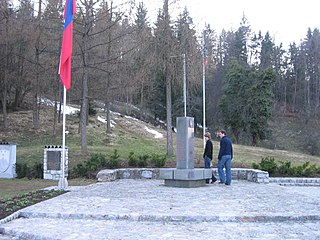
The Geometric Centre of Slovenia is the geometric centre of the country. Its geographic coordinates are 46°07′11.8″N14°48′55.2″E and its elevation is 644.842 m. It lies in the hamlet of Spodnja Slivna near Vače in the Municipality of Litija. Since 4 July 1982, it has been marked with a memorial stone designed by the architect Marjan Božič, about 50 m away from the given coordinates. A plaque reading Živimo in gospodarimo na svoji zemlji was added on 14 September 1989. In 2003, Slovenia adopted the Geometric Centre of Slovenia Act, which is a unique case in Europe.

<span class="mw-page-title-main">Suchowola</span> Place in Podlaskie Voivodeship, Poland

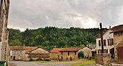
Suchowola is a town in north-eastern Poland in Sokółka County in the Podlaskie Voivodeship, located on both banks of the Olszanka River. Its population is 2,196 (2017).

<span class="mw-page-title-main">Tállya</span> Village in Northern Hungary, Hungary

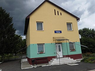
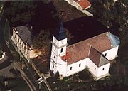
Tállya is a village in Borsod-Abaúj-Zemplén county, Northern Hungary, 45 kilometres from county seat Miskolc, in the famous Tokaj-Hegyalja wine district.

<span class="mw-page-title-main">Pole of inaccessibility</span> Geographic location

A pole of inaccessibility with respect to a geographical criterion of inaccessibility marks a location that is the most challenging to reach according to that criterion. Often it refers to the most distant point from the coastline, implying a maximum degree of continentality or oceanity. In these cases, a pole of inaccessibility can be defined as the center of the largest circle that can be drawn within an area of interest without encountering a coast. Where a coast is imprecisely defined, the pole will be similarly imprecise.

This article lists extreme locations on Earth that hold geographical records or are otherwise known for their geophysical or meteorological superlatives. All of these locations are Earth-wide extremes; extremes of individual continents or countries are not listed.

<span class="mw-page-title-main">Centre points of the United Kingdom</span>

There has long been debate over the exact location of the geographical centre of the United Kingdom, and its constituent countries, due to the complexity and method of the calculation, such as whether to include offshore islands, and the fact that erosion will cause the position to change over time. There are two main methods of calculating this "centre": either as the centroid of the two-dimensional shape made by the country, or as the point farthest from the boundary of the country. These two methods give quite different answers.

This is a list of the extreme points of Europe: the geographical points that are higher or farther north, south, east or west than any other location in Europe. Some of these positions are open to debate, as the definition of Europe is diverse.

<span class="mw-page-title-main">Extreme points of the European Union</span>

This is a list of the extreme points of the European Union — the points that are farther north, south, east or west than any other location.

<span class="mw-page-title-main">Westerngrund</span> Municipality in Bavaria, Germany

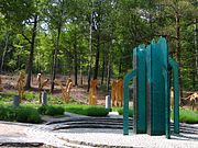
Westerngrund is a community in the Aschaffenburg district in the Regierungsbezirk of Lower Franconia (Unterfranken) in Bavaria, Germany, and a member of the Verwaltungsgemeinschaft of Schöllkrippen. From 2013 to 2020, the geodetic centre of the European Union was located within the community's boundaries.

<span class="mw-page-title-main">Geographical centre of Scotland</span> Geographical center in Perth and Kinross, Scotland, UK

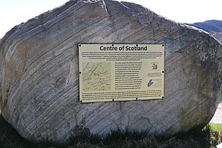
There is some debate as to the location of the geographical centre of Scotland. This is due to different methods of calculating the centre, and whether surrounding islands are included.

In geography, the centroid of the two-dimensional shape of a region of the Earth's surface is known as its geographic centre or geographical centre or gravitational centre. Informally, determining the centroid is often described as finding the point upon which the shape would balance. This method is also sometimes described as the "gravitational method".

The geographical center of Sweden is contested amongst at least four locations.

The geographical centre of Earth is the geometric centre of all land surfaces on Earth. Geometrically defined it is the centroid of all land surfaces within the two dimensions of the Geoid surface which approximates the Earth's outer shape. The term centre of minimum distance specifies the concept more precisely as the domain is the sphere surface without boundary and not the three-dimensional body.

<span class="mw-page-title-main">Geographical midpoint of Asia</span>

The location of the geographical centre of Asia depends on the definition of the borders of Asia, mainly whether remote islands are included to define the extreme points of Asia, and on the method of calculating the final result.

<span class="mw-page-title-main">Dilove</span> Village in Zakarpattia Oblast, Ukraine

Dilove is a village located in Rakhiv Raion of Zakarpattia Oblast in Ukraine.

References

  1. "SVK: Kremnické Bane – Geographical Center Of Europe". en.infoglobe.cz.
  2. "Geographical Centre of Europe: Monument in Rakhiv". Lonely Planet.
  3. "The Museum of Geographical Centre of Europe". Museums of Lithuania.
  4. http://confluence.org/confluence.php?visitid=14714  : "according to the research of the French National Geographic Institute, the one and only geographical central point of the continent is in Lithuania, a fact that even won recognition in the Guinness Book of World Records"
  5. "Geographical centre of Europe" . Retrieved 27 July 2018.
  6. Tapon, Francis (2011). The Hidden Europe: What Eastern Europeans Can Teach Us. SonicTrek. p. 14. ISBN   978-0-9765812-2-2.
  7. Viktor Korbut (2009). "How to reach the centre of Europe". Belarus Magazine. No. 5. Archived from the original on 21 September 2013. Retrieved 21 September 2013.
  8. "Tállya". www.tortenelmi-borut.hu. Archived from the original on 25 September 2013. Retrieved 13 September 2013. According to topographical measurements, Tállya is the geodesic centre of [...] continental Europe
  9. "Suchowola commune (Poland)". In 1775 royal astronomer Szymon Antoni Sobiekrajski published a report in which he stated that Suchowola is the exact geographic centre of Europe
  10. "Pennan kvar på Järnvägsgatan". HD (in Swedish). Retrieved 31 January 2021.
  11. Jan S. Krogh. "Other Places of Interest: Central Europe".
  12. "Europos Parkas: Open Air Museum of the Centre of Europe". EU PHARE 2001 Co-operation in the Baltic Sea Region Programme.
  13. "The geographical Centre of Europe". visitlithuania.net. Retrieved 4 November 2019.
  14. "Tállya Online: Európa Mértani Közepe, Tállya". Archived from the original on 13 May 2008. Retrieved 1 July 2008.
  15. Cristea, George (2001). Jakten på Europas mittpunkt (in Swedish). Stockholm: Carlsson. ISBN   91-7203-435-1.
  16. "Tállya nevezetességei – Közterületi szobrok – Európa mértani középpontja (DSCF6249)" [Sights of Tállya – Public Sculptures – The Geometric Center of Europe (DSCF6249)] (in Hungarian). Archived from the original on 18 November 2009. Retrieved 1 July 2008.
  17. Igor Anisimov (2007). "Letters stamped "From the center of Europe"". No. 5. Belarus Magazine. Archived from the original on 7 February 2012.{{cite magazine}}: Cite magazine requires |magazine= (help)
  18. Российские геодезисты подтвердили нахождение центра Европы в Полоцке - Главные новости - БЕЛТА - новости, события, факты, комментарии [ dead link ]
  19. "Kärla vald tahab Euroopa keskpunkti külalistele avada" (in Estonian). Archived from the original on 26 May 2011. Retrieved 29 November 2008.
  20. Frey, George (5 January 2007). "5 January 2007". Signonsandiego.com. Archived from the original on 11 September 2012. Retrieved 3 January 2011.
  21. "OpenStreetMap".
  22. Connolly, Kate (6 April 2017). "Gadheim – the Bavarian hamlet set to become the centre of a post-Brexit EU". The Guardian. Retrieved 5 September 2017.

Further reading

A film about the "Center of Europe"

A 2004 Polish-German documentary, Środek Europy (Die Mitte, "The Center"), written and directed by Stanisław Mucha, shows over a dozen different locations. [1]