Continent | Asia |
---|---|
Region | Central Asia / South Asia |
Coordinates | 33°00′N65°00′E / 33.000°N 65.000°E |
Area | Ranked 40th |
• Total | 647,230 km2 (249,900 sq mi) |
Coastline | 0 km (0 mi) |
Borders | Pakistan 2,670 km (1,660 mi), Tajikistan 1,357 km (843 mi), Iran 921 km (572 mi), Turkmenistan 804 km (500 mi), Uzbekistan 144 km (89 mi), China 91 km (57 mi) |
Highest point | Noshaq, 7,492 m (24,580 ft) |
Lowest point | Amu Darya at Khamyab, 258 m (846 ft) |
Longest river | Helmand River |
Largest lake | Kamal Khan Dam Kajaki Dam Dahla Dam Naghlu Dam Band-e Amir Qargha |
Climate | Arid to semiarid; cold winters and hot summers |
Terrain | mostly low plateau with deserts, rangelands and a fertile plain in the southeast |
Natural resources | natural gas, petroleum, coal, copper, chromite, talc, barites, sulfur, lead, zinc, iron ore, salt, precious and semiprecious stone [1] [2] [3] [4] [5] |
Natural hazards | earthquakes, flooding, avalanches |
Environmental issues | limited fresh water, soil degradation, overgrazing, deforestation, desertification, air pollution, water pollution |
Afghanistan is a landlocked mountainous country located on the Iranian Plateau, [6] at the crossroads of Central Asia [7] [8] and South Asia. [9] [10] The country is the 40th largest in the world in size. Kabul is the capital and largest city of Afghanistan, located in the Kabul Province. With a location at the intersection of major trade routes, Afghanistan has attracted a succession of invaders since the sixth century BCE. [11]
Afghanistan contains most of the Hindu Kush. There are a number of major rivers in the country, including Amu Darya, Arghandab, Farah, Hari, Helmand, Kabul, Kokcha, and Kunar. The country also possesses many smaller rivers as well as streams, canals, lakes, ponds, and springs. Most of its fresh water has been historically flowing into neighboring countries. [12]
Rainfall in Afghanistan is very scarce, and mainly only affects the northern highlands, arriving in March and April. Rainfall in the more arid lowlands is rare, and can be very unpredictable. [13] Marked characteristics are the great differences of summer and winter temperature and of day and night temperature, as well as the extent to which change of climate can be attained by slight change of place. The Afghan climate is a dry one. The sun shines for three-fourths of the year, and the nights are clearer than the days.
Taking the highlands of the country as a whole, there is no great difference between the mean temperature of Afghanistan and that of the lower Himalaya. However, a remarkable feature of the Afghan climate is its extreme temperature range within limited periods. The smallest daily range in the north is when the weather is cold; the greatest is when it is hot. For seven months of the year (from May to November) this range exceeds 17 °C (31 °F) daily. Waves of intense cold occur, lasting for several days, and one may have to endure temperatures of −24 °C (−11 °F), rising to a maximum of −8 °C (18 °F). At Ghazni the snow has been known to stay long beyond the vernal equinox; the temperatures sink as low as −25 °C (−13 °F). Oral tradition tells of the destruction of the entire population of Ghazni by snowstorms on more than one occasion.[ citation needed ] On the other hand, the summer temperature is exceedingly high, especially in the Oxus regions, where a shade maximum of 45–50 °C (113–122 °F) is not uncommon.
The summer heat is strong in the Sistan Basin, Jalalabad and Turkestan. The simoom wind occurs in Kandahar province during the summer. The hot season is rendered more intense by frequent dust storms and strong winds; whilst the bare rocky ridges that traverse the country, absorbing heat by day and radiating it by night, render the summer nights most oppressive. In Kabul the heat is tempered occasionally by cool breezes from the Hindu Kush, and the nights are usually cool. In Kandahar snow seldom falls on the plains or lower hills; when it does, it melts at once.
The combination of hot summers and bitterly cold winters has been noted comparable to the U.S. state of Wyoming. [14]
The summer rains that accompany the southwest monsoon in India, beat along the southern slopes of the Himalaya, and travel up the Kabul valley as far as Laghman, though they are more clearly felt in Bajour and Panjkora, under the Hindu Kush, and in the eastern branches of Safed Koh. Rain also falls at this season at the head of Kurram valley. South of this the Suliman mountains may be taken as the western limit of the monsoon's action. It is not felt in the rest of Afghanistan, in which, as in the rest of western Asia, the winter rains and snow are the most considerable. The spring rain, though less copious, is more important to agriculture than the winter rain, unless where the latter falls in the form of snow. In the absence of monsoon influences there are steadier weather indications than in India. The north-west blizzards which occur in winter and spring are the most noticeable feature, and their influence is clearly felt on the Indian frontier.
Climate data for Kabul (1956–1983) | |||||||||||||
---|---|---|---|---|---|---|---|---|---|---|---|---|---|
Month | Jan | Feb | Mar | Apr | May | Jun | Jul | Aug | Sep | Oct | Nov | Dec | Year |
Record high °C (°F) | 18.8 (65.8) | 18.4 (65.1) | 26.7 (80.1) | 28.7 (83.7) | 33.5 (92.3) | 36.8 (98.2) | 37.8 (100.0) | 37.3 (99.1) | 35.1 (95.2) | 31.6 (88.9) | 24.4 (75.9) | 20.4 (68.7) | 37.8 (100.0) |
Mean daily maximum °C (°F) | 4.5 (40.1) | 5.5 (41.9) | 12.5 (54.5) | 19.2 (66.6) | 24.4 (75.9) | 30.2 (86.4) | 32.1 (89.8) | 32.0 (89.6) | 28.5 (83.3) | 22.4 (72.3) | 15.0 (59.0) | 8.3 (46.9) | 19.5 (67.1) |
Daily mean °C (°F) | −2.3 (27.9) | −0.7 (30.7) | 6.3 (43.3) | 12.8 (55.0) | 17.3 (63.1) | 22.8 (73.0) | 25.0 (77.0) | 24.1 (75.4) | 19.7 (67.5) | 13.1 (55.6) | 5.9 (42.6) | 0.6 (33.1) | 12.1 (53.8) |
Mean daily minimum °C (°F) | −7.1 (19.2) | −5.7 (21.7) | 0.7 (33.3) | 6.0 (42.8) | 8.8 (47.8) | 12.4 (54.3) | 15.3 (59.5) | 14.3 (57.7) | 9.4 (48.9) | 3.9 (39.0) | −1.2 (29.8) | −4.7 (23.5) | 4.3 (39.7) |
Record low °C (°F) | −25.5 (−13.9) | −24.8 (−12.6) | −12.6 (9.3) | −2.1 (28.2) | 0.4 (32.7) | 3.1 (37.6) | 7.5 (45.5) | 6.0 (42.8) | 1.0 (33.8) | −3.0 (26.6) | −9.4 (15.1) | −18.9 (−2.0) | −25.5 (−13.9) |
Average precipitation mm (inches) | 34.3 (1.35) | 60.1 (2.37) | 67.9 (2.67) | 71.9 (2.83) | 23.4 (0.92) | 1.0 (0.04) | 6.2 (0.24) | 1.6 (0.06) | 1.7 (0.07) | 3.7 (0.15) | 18.6 (0.73) | 21.6 (0.85) | 312.0 (12.28) |
Average rainy days | 2 | 3 | 10 | 11 | 8 | 1 | 2 | 1 | 1 | 2 | 4 | 3 | 48 |
Average snowy days | 7 | 6 | 3 | 0 | 0 | 0 | 0 | 0 | 0 | 0 | 0 | 4 | 20 |
Average relative humidity (%) | 68 | 70 | 65 | 61 | 48 | 36 | 37 | 38 | 39 | 42 | 52 | 63 | 52 |
Mean monthly sunshine hours | 177.2 | 178.6 | 204.5 | 232.5 | 310.3 | 353.4 | 356.8 | 339.7 | 303.9 | 282.6 | 253.2 | 182.4 | 3,175.1 |
Source: NOAA [16] |
Climate data for Jalalabad | |||||||||||||
---|---|---|---|---|---|---|---|---|---|---|---|---|---|
Month | Jan | Feb | Mar | Apr | May | Jun | Jul | Aug | Sep | Oct | Nov | Dec | Year |
Record high °C (°F) | 25.0 (77.0) | 28.8 (83.8) | 34.5 (94.1) | 40.5 (104.9) | 45.4 (113.7) | 47.5 (117.5) | 44.7 (112.5) | 42.4 (108.3) | 41.2 (106.2) | 38.2 (100.8) | 32.4 (90.3) | 25.4 (77.7) | 47.5 (117.5) |
Mean daily maximum °C (°F) | 15.9 (60.6) | 17.9 (64.2) | 22.5 (72.5) | 28.3 (82.9) | 34.7 (94.5) | 40.4 (104.7) | 39.3 (102.7) | 38.0 (100.4) | 35.2 (95.4) | 30.5 (86.9) | 23.3 (73.9) | 17.5 (63.5) | 28.6 (83.5) |
Daily mean °C (°F) | 8.5 (47.3) | 10.9 (51.6) | 16.3 (61.3) | 21.9 (71.4) | 27.7 (81.9) | 32.7 (90.9) | 32.8 (91.0) | 31.9 (89.4) | 28.1 (82.6) | 22.2 (72.0) | 14.9 (58.8) | 9.5 (49.1) | 21.5 (70.6) |
Mean daily minimum °C (°F) | 2.9 (37.2) | 5.6 (42.1) | 10.5 (50.9) | 15.3 (59.5) | 19.8 (67.6) | 24.7 (76.5) | 26.7 (80.1) | 26.2 (79.2) | 21.4 (70.5) | 14.4 (57.9) | 6.9 (44.4) | 3.5 (38.3) | 14.8 (58.7) |
Record low °C (°F) | −14.1 (6.6) | −9.5 (14.9) | −1.0 (30.2) | 6.1 (43.0) | 10.6 (51.1) | 13.5 (56.3) | 19.0 (66.2) | 17.5 (63.5) | 11.0 (51.8) | 2.7 (36.9) | −4.5 (23.9) | −5.5 (22.1) | −14.1 (6.6) |
Average precipitation mm (inches) | 18.1 (0.71) | 24.3 (0.96) | 39.2 (1.54) | 36.4 (1.43) | 16.0 (0.63) | 1.4 (0.06) | 6.9 (0.27) | 7.7 (0.30) | 8.3 (0.33) | 3.2 (0.13) | 8.3 (0.33) | 12.1 (0.48) | 181.9 (7.17) |
Average rainy days | 4 | 5 | 8 | 8 | 4 | 1 | 1 | 1 | 1 | 1 | 2 | 3 | 39 |
Average relative humidity (%) | 61 | 60 | 62 | 59 | 47 | 40 | 52 | 58 | 56 | 55 | 58 | 63 | 56 |
Mean monthly sunshine hours | 180.9 | 182.7 | 207.1 | 227.8 | 304.8 | 339.6 | 325.9 | 299.7 | 293.6 | 277.6 | 231.0 | 185.6 | 3,056.3 |
Source: NOAA (1964-1983) [17] |
Climate data for Herāt | |||||||||||||
---|---|---|---|---|---|---|---|---|---|---|---|---|---|
Month | Jan | Feb | Mar | Apr | May | Jun | Jul | Aug | Sep | Oct | Nov | Dec | Year |
Record high °C (°F) | 24.4 (75.9) | 27.6 (81.7) | 31.0 (87.8) | 37.8 (100.0) | 39.7 (103.5) | 44.6 (112.3) | 50.7 (123.3) | 42.7 (108.9) | 39.3 (102.7) | 37.0 (98.6) | 30.0 (86.0) | 26.5 (79.7) | 50.7 (123.3) |
Mean daily maximum °C (°F) | 9.1 (48.4) | 11.9 (53.4) | 17.9 (64.2) | 24.0 (75.2) | 29.6 (85.3) | 35.0 (95.0) | 36.7 (98.1) | 35.1 (95.2) | 31.4 (88.5) | 25.0 (77.0) | 17.8 (64.0) | 12.0 (53.6) | 23.8 (74.8) |
Daily mean °C (°F) | 2.9 (37.2) | 5.5 (41.9) | 10.2 (50.4) | 16.3 (61.3) | 22.1 (71.8) | 27.2 (81.0) | 29.8 (85.6) | 28.0 (82.4) | 22.9 (73.2) | 16.1 (61.0) | 8.8 (47.8) | 4.7 (40.5) | 16.2 (61.2) |
Mean daily minimum °C (°F) | −2.9 (26.8) | −0.6 (30.9) | 3.8 (38.8) | 9.1 (48.4) | 13.3 (55.9) | 18.2 (64.8) | 21.2 (70.2) | 19.2 (66.6) | 13.2 (55.8) | 7.4 (45.3) | 1.0 (33.8) | −1.4 (29.5) | 8.5 (47.2) |
Record low °C (°F) | −26.7 (−16.1) | −20.5 (−4.9) | −13.3 (8.1) | −2.3 (27.9) | 0.8 (33.4) | 9.7 (49.5) | 13.3 (55.9) | 8.4 (47.1) | 1.3 (34.3) | −5.6 (21.9) | −12.8 (9.0) | −22.7 (−8.9) | −26.7 (−16.1) |
Average precipitation mm (inches) | 51.6 (2.03) | 44.8 (1.76) | 55.1 (2.17) | 29.2 (1.15) | 9.8 (0.39) | 0.0 (0.0) | 0.0 (0.0) | 0.0 (0.0) | 0.0 (0.0) | 1.7 (0.07) | 10.9 (0.43) | 35.8 (1.41) | 238.9 (9.41) |
Average rainy days | 6 | 8 | 8 | 7 | 2 | 0 | 0 | 0 | 0 | 1 | 3 | 5 | 40 |
Average snowy days | 2 | 2 | 1 | 0 | 0 | 0 | 0 | 0 | 0 | 0 | 0 | 1 | 6 |
Average relative humidity (%) | 72 | 69 | 62 | 56 | 45 | 34 | 30 | 30 | 34 | 42 | 55 | 67 | 50 |
Mean monthly sunshine hours | 149.3 | 153.5 | 202.5 | 235.7 | 329.6 | 362.6 | 378.6 | 344.8 | 323.2 | 274.0 | 235.0 | 143.1 | 3,131.9 |
Source 1: NOAA (1959–1983) [18] | |||||||||||||
Source 2: Ogimet [19] |
Climate data for Kandahar (1964–1983) | |||||||||||||
---|---|---|---|---|---|---|---|---|---|---|---|---|---|
Month | Jan | Feb | Mar | Apr | May | Jun | Jul | Aug | Sep | Oct | Nov | Dec | Year |
Record high °C (°F) | 25.0 (77.0) | 26.0 (78.8) | 36.5 (97.7) | 37.1 (98.8) | 43.0 (109.4) | 45.0 (113.0) | 46.5 (115.7) | 44.5 (112.1) | 41.0 (105.8) | 37.5 (99.5) | 31.5 (88.7) | 26.0 (78.8) | 46.5 (115.7) |
Mean daily maximum °C (°F) | 12.2 (54.0) | 14.8 (58.6) | 21.6 (70.9) | 28.1 (82.6) | 34.1 (93.4) | 39.1 (102.4) | 40.2 (104.4) | 38.2 (100.8) | 34.0 (93.2) | 27.5 (81.5) | 21.0 (69.8) | 15.4 (59.7) | 27.2 (81.0) |
Daily mean °C (°F) | 5.1 (41.2) | 7.8 (46.0) | 13.9 (57.0) | 20.2 (68.4) | 25.4 (77.7) | 30.0 (86.0) | 31.9 (89.4) | 29.4 (84.9) | 23.5 (74.3) | 17.5 (63.5) | 11.0 (51.8) | 7.3 (45.1) | 18.6 (65.4) |
Mean daily minimum °C (°F) | 0.0 (32.0) | 2.4 (36.3) | 7.1 (44.8) | 12.3 (54.1) | 15.8 (60.4) | 19.5 (67.1) | 22.5 (72.5) | 20.0 (68.0) | 13.5 (56.3) | 8.5 (47.3) | 3.3 (37.9) | 1.0 (33.8) | 10.5 (50.9) |
Record low °C (°F) | −12.1 (10.2) | −10.0 (14.0) | −4.8 (23.4) | 2.0 (35.6) | 2.4 (36.3) | 8.5 (47.3) | 13.5 (56.3) | 9.0 (48.2) | 5.2 (41.4) | −2.2 (28.0) | −9.3 (15.3) | −11.4 (11.5) | −12.1 (10.2) |
Average precipitation mm (inches) | 54.0 (2.13) | 42.0 (1.65) | 41.1 (1.62) | 18.7 (0.74) | 2.2 (0.09) | 0 (0) | 2.3 (0.09) | 1.0 (0.04) | 0 (0) | 2.3 (0.09) | 7.0 (0.28) | 20.0 (0.79) | 190.6 (7.52) |
Average precipitation days | 6 | 6 | 6 | 4 | 1 | 0 | 0 | 0 | 0 | 1 | 2 | 3 | 29 |
Average relative humidity (%) | 58 | 59 | 50 | 41 | 30 | 23 | 25 | 25 | 24 | 29 | 40 | 52 | 38 |
Mean monthly sunshine hours | 198.4 | 183.6 | 235.6 | 255.0 | 347.2 | 369.0 | 341.0 | 337.9 | 324.0 | 306.9 | 264.0 | 217.0 | 3,379.6 |
Source: NOAA (1964–1983) [20] |
Climate data for Zaranj | |||||||||||||
---|---|---|---|---|---|---|---|---|---|---|---|---|---|
Month | Jan | Feb | Mar | Apr | May | Jun | Jul | Aug | Sep | Oct | Nov | Dec | Year |
Record high °C (°F) | 24.1 (75.4) | 30.6 (87.1) | 37.0 (98.6) | 45.0 (113.0) | 51.0 (123.8) | 49.7 (121.5) | 49.3 (120.7) | 50.0 (122.0) | 49.7 (121.5) | 42.0 (107.6) | 36.0 (96.8) | 27.8 (82.0) | 51.0 (123.8) |
Mean daily maximum °C (°F) | 14.3 (57.7) | 18.7 (65.7) | 25.0 (77.0) | 32.6 (90.7) | 37.3 (99.1) | 42.8 (109.0) | 42.5 (108.5) | 41.3 (106.3) | 37.0 (98.6) | 31.2 (88.2) | 23.1 (73.6) | 17.7 (63.9) | 30.3 (86.5) |
Daily mean °C (°F) | 6.5 (43.7) | 10.0 (50.0) | 15.7 (60.3) | 23.3 (73.9) | 29.1 (84.4) | 33.4 (92.1) | 35.0 (95.0) | 32.3 (90.1) | 27.2 (81.0) | 21.9 (71.4) | 13.1 (55.6) | 8.7 (47.7) | 21.3 (70.4) |
Mean daily minimum °C (°F) | 0.1 (32.2) | 2.9 (37.2) | 7.7 (45.9) | 14.7 (58.5) | 20.0 (68.0) | 25.2 (77.4) | 27.3 (81.1) | 24.9 (76.8) | 18.5 (65.3) | 12.3 (54.1) | 4.8 (40.6) | 0.7 (33.3) | 13.3 (55.9) |
Record low °C (°F) | −13.2 (8.2) | −8.2 (17.2) | −5.2 (22.6) | 1.0 (33.8) | 5.0 (41.0) | 16.0 (60.8) | 18.4 (65.1) | 13.2 (55.8) | 3.9 (39.0) | −2.7 (27.1) | −7.1 (19.2) | −8.8 (16.2) | −13.2 (8.2) |
Average precipitation mm (inches) | 19.7 (0.78) | 9.9 (0.39) | 11.2 (0.44) | 2.4 (0.09) | 0.6 (0.02) | 0.0 (0.0) | 0.0 (0.0) | 0.0 (0.0) | 0.0 (0.0) | 1.2 (0.05) | 1.4 (0.06) | 5.1 (0.20) | 51.5 (2.03) |
Average rainy days | 3 | 2 | 2 | 2 | 0 | 0 | 0 | 0 | 0 | 0 | 1 | 1 | 11 |
Average relative humidity (%) | 55 | 50 | 44 | 40 | 35 | 29 | 28 | 29 | 33 | 41 | 49 | 54 | 41 |
Source: NOAA (1969-1983) [21] |
Climate data for Mazar-i-Sharif | |||||||||||||
---|---|---|---|---|---|---|---|---|---|---|---|---|---|
Month | Jan | Feb | Mar | Apr | May | Jun | Jul | Aug | Sep | Oct | Nov | Dec | Year |
Record high °C (°F) | 24.0 (75.2) | 28.6 (83.5) | 32.4 (90.3) | 37.8 (100.0) | 43.0 (109.4) | 45.6 (114.1) | 48.1 (118.6) | 46.0 (114.8) | 39.5 (103.1) | 37.0 (98.6) | 29.8 (85.6) | 24.4 (75.9) | 48.1 (118.6) |
Mean daily maximum °C (°F) | 8.0 (46.4) | 10.7 (51.3) | 16.3 (61.3) | 24.3 (75.7) | 31.2 (88.2) | 37.0 (98.6) | 38.9 (102.0) | 36.9 (98.4) | 31.9 (89.4) | 24.7 (76.5) | 16.4 (61.5) | 10.8 (51.4) | 23.9 (75.1) |
Daily mean °C (°F) | 2.6 (36.7) | 5.1 (41.2) | 10.8 (51.4) | 17.9 (64.2) | 24.5 (76.1) | 29.9 (85.8) | 33.3 (91.9) | 29.9 (85.8) | 23.9 (75.0) | 16.7 (62.1) | 9.1 (48.4) | 5.1 (41.2) | 17.4 (63.3) |
Mean daily minimum °C (°F) | −2.1 (28.2) | 0.0 (32.0) | 5.1 (41.2) | 11.3 (52.3) | 16.6 (61.9) | 22.5 (72.5) | 25.9 (78.6) | 23.8 (74.8) | 17.1 (62.8) | 9.4 (48.9) | 3.2 (37.8) | 0.0 (32.0) | 11.1 (51.9) |
Record low °C (°F) | −22.3 (−8.1) | −24.0 (−11.2) | −6.1 (21.0) | −0.8 (30.6) | 1.0 (33.8) | 11.4 (52.5) | 11.1 (52.0) | 13.7 (56.7) | 2.6 (36.7) | 4.5 (40.1) | −8.7 (16.3) | −15.5 (4.1) | −24.0 (−11.2) |
Average precipitation mm (inches) | 28.9 (1.14) | 34.8 (1.37) | 43.8 (1.72) | 28.3 (1.11) | 11.2 (0.44) | 0.2 (0.01) | 0.0 (0.0) | 0.0 (0.0) | 0.1 (0.00) | 3.9 (0.15) | 13.5 (0.53) | 21.7 (0.85) | 186.4 (7.32) |
Average rainy days | 4 | 7 | 10 | 9 | 4 | 0 | 0 | 0 | 0 | 2 | 4 | 6 | 46 |
Average snowy days | 4 | 3 | 1 | 0 | 0 | 0 | 0 | 0 | 0 | 0 | 0 | 2 | 10 |
Average relative humidity (%) | 79 | 77 | 72 | 64 | 44 | 27 | 25 | 24 | 28 | 41 | 62 | 75 | 52 |
Mean monthly sunshine hours | 122.2 | 118.4 | 158.1 | 193.8 | 299.9 | 352.9 | 364.4 | 332.7 | 298.2 | 223.2 | 173.6 | 125.5 | 2,762.9 |
Source: NOAA (1959–1983) [22] |
Climate data for Kunduz | |||||||||||||
---|---|---|---|---|---|---|---|---|---|---|---|---|---|
Month | Jan | Feb | Mar | Apr | May | Jun | Jul | Aug | Sep | Oct | Nov | Dec | Year |
Record high °C (°F) | 21.2 (70.2) | 25.0 (77.0) | 32.8 (91.0) | 38.9 (102.0) | 42.2 (108.0) | 46.2 (115.2) | 45.3 (113.5) | 44.2 (111.6) | 39.2 (102.6) | 39.4 (102.9) | 28.4 (83.1) | 21.6 (70.9) | 46.2 (115.2) |
Mean daily maximum °C (°F) | 6.3 (43.3) | 9.5 (49.1) | 15.8 (60.4) | 23.0 (73.4) | 29.8 (85.6) | 37.3 (99.1) | 39.0 (102.2) | 36.9 (98.4) | 31.8 (89.2) | 24.5 (76.1) | 16.0 (60.8) | 9.7 (49.5) | 23.3 (73.9) |
Daily mean °C (°F) | 1.6 (34.9) | 4.4 (39.9) | 10.4 (50.7) | 17.2 (63.0) | 22.9 (73.2) | 29.3 (84.7) | 31.3 (88.3) | 29.2 (84.6) | 23.9 (75.0) | 16.9 (62.4) | 9.5 (49.1) | 4.4 (39.9) | 16.8 (62.1) |
Mean daily minimum °C (°F) | −2.4 (27.7) | 0.0 (32.0) | 5.7 (42.3) | 11.6 (52.9) | 15.7 (60.3) | 20.9 (69.6) | 23.3 (73.9) | 21.5 (70.7) | 16.3 (61.3) | 10.6 (51.1) | 4.1 (39.4) | 0.0 (32.0) | 10.6 (51.1) |
Record low °C (°F) | −22.7 (−8.9) | −23.1 (−9.6) | −11.8 (10.8) | −2.1 (28.2) | 4.2 (39.6) | 12.5 (54.5) | 15.7 (60.3) | 12.6 (54.7) | 3.5 (38.3) | −2.0 (28.4) | −9.8 (14.4) | −20 (−4) | −23.1 (−9.6) |
Average precipitation mm (inches) | 44.0 (1.73) | 56.5 (2.22) | 76.7 (3.02) | 54.4 (2.14) | 29.8 (1.17) | 0.1 (0.00) | 1.3 (0.05) | 0.3 (0.01) | 0.1 (0.00) | 7.3 (0.29) | 23.7 (0.93) | 28.4 (1.12) | 322.6 (12.68) |
Average rainy days | 5 | 6 | 11 | 10 | 9 | 1 | 1 | 0 | 0 | 3 | 5 | 6 | 57 |
Average snowy days | 5 | 4 | 2 | 0 | 0 | 0 | 0 | 0 | 0 | 0 | 1 | 2 | 14 |
Average relative humidity (%) | 80 | 75 | 75 | 71 | 54 | 31 | 28 | 29 | 32 | 44 | 63 | 76 | 55 |
Mean monthly sunshine hours | 114.4 | 114.6 | 158.9 | 201.0 | 276.5 | 332.1 | 340.2 | 315.5 | 289.7 | 221.8 | 169.3 | 118.3 | 2,652.3 |
Source: NOAA (1958-1983) [23] |
The Hindu Kush mountain range reaches a height of 7,492 m (24,580 ft) at Noshaq, Afghanistan's highest peak. Of the ranges extending southwestward from the Hindu Kush, the Foladi peak (Shah Foladi) of the Baba mountain range ( Koh-i-Baba ) reaches the greatest height: 5,142 m (16,870 ft). The Safed Koh range, which includes the Tora Bora area, dominates the border area southeast of Kabul.
Important passes include the Unai Pass across the Safed Koh, the Kushan and Salang Passes through the Hindu Kush, and the Khyber Pass that connects Afghanistan with Pakistan. The summit of the Khyber Pass at 1,070 m (3,510 ft) at Landi Kotal, Pakistan is 5 km (3 mi) east of the border town of Torkham. Other key passages through the mountainous Pakistan border include two from Paktika Province into Pakistan's Waziristan region: one at Angoor Ada, and one further south at the Gumal River crossing, plus the Charkai River passage south of Khost, Afghanistan, at Pakistan's Ghulam Khan village into North Waziristan. The busy Pak-Afghan border crossing at Wesh, Afghanistan is in a flat and dry area, though this route involves Pakistan's Khojak Pass at 2,707 m (8,881 ft) just 14 km (9 mi) from the border. The border connects Kandahar and Spin Boldak in Afghanistan with Quetta in Pakistan.
The Wakhan Corridor in the northeast lies eastward of the province of Panjshir, between the Hindu Kush and the Pamir Mountains, which leads to the Wakhjir Pass into Xinjiang in China. In Kabul, and over all the northern part of the country to the descent at Gandamak, winter is rigorous, especially so on the high Arachosian plateau.
Although Herat is approximately 240 m (787 ft) lower than Kandahar, the summer climate there is more temperate along with the yearly climate. From May to September, the wind blows from the northwest with great force, and this extends across the country to Kandahar. The winter is mild; snow melts as it falls, and even on the mountains does not lie long. Three years out of four at Herat it does not freeze hard enough for the people to store ice. Yet, it was not very far from Herat, in Rafir Kala, in 1750, where Ahmad Shah's army, retreating from Persia, is said to have lost 18,000 men from cold in a single night. In the northern Herat districts records of the coldest month (February) show the mean minimum as −8 °C (18 °F) and the maximum as 3 °C (37 °F). The eastern reaches of the Hari River, including the rapids, are frozen hard in the winter, and people travel on it as on a road.
Afghanistan receives snow between November and March, which gradually melts into numerous rivers, streams, canals, lakes, ponds, and springs, but most of the country's fresh water continues to flow into neighboring countries. [24] It loses about two-thirds of its water to neighboring Pakistan, Iran, Tajikistan, Uzbekistan and Turkmenistan. [12]
The nation's drainage system is largely landlocked.
The characteristic distribution of vegetation on the mountains of Afghanistan is worthy of attention. The great mass of it is confined to the main ranges and their immediate offshoots, whilst on the more distant and terminal prolongations it is almost entirely absent; in fact, these are naked rock and stone. On the Safed Koh alpine range itself and its immediate branches, at a height of 1,800–3,000 m (5,900–9,800 ft) there is abundant growth of large forest trees, among which conifers are the most noble and prominent, such as Cedrus deodara , Abies excelsa , Pinus longifolia , Pinus pinaster , Stone pine (the edible pine, although this species is probably introduced, since it is original to Spain and Portugal) and the larch. There is also the yew, the hazel, juniper, walnut, wild peach and almond. Growing under the shade of these are several varieties of rose, honeysuckle, currant, gooseberry, hawthorn, rhododendron and a luxuriant herbage, among which the ranunculus family is important for frequency and number of genera. The lemon and wild vine are also here met with, but are more common on the northern mountains. The walnut and oak (evergreen, holly-leaved and kermes) descend to the secondary heights, where they become mixed with alder, ash, khinjak, Arbor-vitae, juniper, with species of Astragalus. Here also are Indigoferae rind dwarf laburnum.
Down to 1,000 m (3,300 ft) there are wild olive, species of rock-rose, wild privet, acacias and mimosas, barberry and Zizyphus ; and in the eastern ramifications of the chain, Nannerops ritchiana (which is applied to a variety of useful purposes), Bignonia or trumpet flower, sissu, Salvadora persica , verbena, acanthus, varieties of Gesnerae.
The lowest terminal ridges, especially towards the west, are, as it has been said, naked in aspect. Their scanty vegetation is almost wholly herbal; shrubs are only occasional; trees almost non-existent. Labiate, composite and umbelliferous plants are most common. Ferns and mosses are almost confined to the higher ranges.
In the low brushwood scattered over portions of the dreary plains of the Kandahar tablelands, it is possible to find leguminous thorny plants of the papilionaceous suborder, such as camel-thorn ( Hedysarum alhagi ), Astragalus in several varieties, spiny rest-harrow ( Ononis spinosa), the fibrous roots of which often serve as a tooth-brush; plants of the sub-order Mimosae, as the sensitive mimosa; a plant of the rue family, called by the natives lipad; the common wormwood; also certain orchids, and several species of Salsola. The rue and wormwood are in general use as domestic medicines—the former for rheumatism and neuralgia; the latter in fever, debility and dyspepsia, as well as for a vermifuge. The lipad, owing to its heavy nauseous odour, is believed to keep off evil spirits. In some places, occupying the sides and hollows of ravines, it is found the Rose Bay, called in Persian khar-zarah, or ass-bane, the wild laburnum and various Indigoferae.
In the last several decades, 90% of forests in Afghanistan have been destroyed and much of the timber has been exported to neighboring Pakistan. As a result, large percent of Afghanistan's land could be subject to soil erosion and desertification. On the positive note, the Karzai administration and international organizations are helping counter this problem by often planting millions of saplings. [25] Afghanistan had a 2018 Forest Landscape Integrity Index mean score of 8.85/10, ranking it 15th globally out of 172 countries. [26]
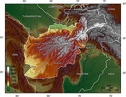
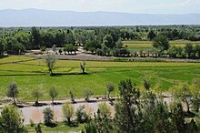
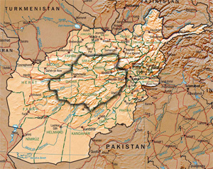
Afghanistan, officially the Islamic Emirate of Afghanistan, is a landlocked country located at the crossroads of Central Asia and South Asia. Referred to as the Heart of Asia, it is bordered by Pakistan to the east and south, Iran to the west, Turkmenistan to the northwest, Uzbekistan to the north, Tajikistan to the northeast, and China to the northeast and east. Occupying 652,864 square kilometers (252,072 sq mi) of land, the country is predominantly mountainous with plains in the north and the southwest, which are separated by the Hindu Kush mountain range. Kabul is the country's largest city and serves as its capital. According to the World Population review, as of 2021, Afghanistan's population is 40.2 million. The National Statistics Information Authority of Afghanistan estimated the population to be 32.9 million as of 2020.
Kandahar is a city in Afghanistan, located in the south of the country on the Arghandab River, at an elevation of 1,010 m (3,310 ft). It is Afghanistan's second largest city after Kabul, with a population of about 614,118. It is the capital of Kandahar Province and the centre of the larger cultural region called Loy Kandahar. Kandahar is the founding city and spiritual center of the Taliban. Despite the capital of Afghanistan being Kabul, where the government administration is based, Kandahar is the seat of power in Afghanistan as the supreme leader and his spiritual advisers are based there. Kandahar has therefore been called the de facto capital of Afghanistan, though the Taliban maintain Kabul is the capital.
The Geography of Pakistan encompasses a wide variety of landscapes varying from plains to deserts, forests, and plateaus ranging from the coastal areas of the Indian Ocean in the south to the mountains of the Karakoram, Hindukush, Himalayas ranges in the north. Pakistan geologically overlaps both with the Indian and the Eurasian tectonic plates where its Sindh and Punjab provinces lie on the north-western corner of the Indian plate while Balochistan and most of the Khyber Pakhtunkhwa lie within the Eurasian plate which mainly comprises the Iranian Plateau.
The Himalayas, or Himalaya, is a mountain range in Asia, separating the plains of the Indian subcontinent from the Tibetan Plateau. The range has some of the Earth's highest peaks, including the highest, Mount Everest; more than 100 peaks exceeding elevations of 7,200 m (23,600 ft) above sea level lie in the Himalayas.
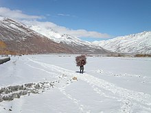
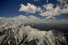
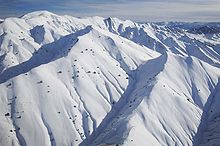
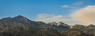
The Hindu Kush is an 800-kilometre-long (500 mi) mountain range on the Iranian Plateau in Central and South Asia to the west of the Himalayas. It stretches from central and eastern Afghanistan into northwestern Pakistan and far southeastern Tajikistan. The range forms the western section of the Hindu Kush Himalayan Region (HKH); to the north, near its northeastern end, the Hindu Kush buttresses the Pamir Mountains near the point where the borders of China, Pakistan and Afghanistan meet, after which it runs southwest through Pakistan and into Afghanistan near their border.
Hazarajat, also known as Hazaristan, is a mostly mountainous region in the central highlands of Afghanistan, among the Kuh-e Baba mountains in the western extremities of the Hindu Kush. It is the homeland of the Hazara people who make up the majority of its population. Hazarajat denotes an ethnic and religious zone.
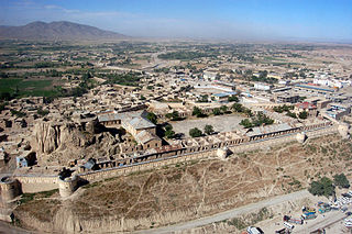
Gardez is the capital of the Paktia Province of Afghanistan. The population of the city was estimated to be ca. 10,000 in the 1979 census and was estimated to be 70,000 in 2008. The majority of the city's native population is Pashtun. The city of Gardez is located at the junction between two important roads that cut, through a huge alpine valley. Surrounded by the mountains and deserts of the Hindu Kush, which boil up from the valley floor to the north, east and west, it is the axis of commerce for a huge area of eastern Afghanistan and has been a strategic location for armies throughout the country's long history of conflict. Observation posts built by Alexander the Great are still crumbling on the hilltops just outside the city limits. The city of Gardez has a population of 70,641. It has 13 districts and a total land area of 6,174 hectares (23.84 sq mi). The total number of dwellings in this city is 7,849.
Maymana is the capital city of Faryab Province in northwestern Afghanistan, near the Afghanistan–Turkmenistan border. It is approximately 400 km (250 mi) northwest of the country's capital Kabul, and is located on the Maymana River, which is a tributary of the Murghab River. The population of Maymana was 149,040 in 2015, making it one of the largest cities of northwestern Afghanistan.
The Spīn Ghar or Safēd Kōh meaning both White Mountains, or sometimes meaning white mountain range, is a mountain range to the south of the Hindu Kush. It ranges from eastern Afghanistan into Khyber Pakhtunkhwa, Pakistan, and forms a natural border between the two areas. Its highest peak is Mount Sikaram on the Afghanistan–Pakistan border, which towers above all surrounding hills to 4,755 m (15,600 ft) above mean sea level. The lower hills are mostly barren and treeless, but pine grows on the main mountains that form the East Afghan montane conifer forests.
Environmental issues in Afghanistan are monitored by the National Environmental Protection Agency (NEPA). They predate the political turmoil of the past few decades. Forests have been depleted by centuries of grazing and farming, practices which have only increased with modern population growth.
Mount Sikaram is a mountain on the Afghanistan–Pakistan border, south of the Kabul River and Khyber Pass. At 4,755 m (15,600 ft), it is the highest peak of the Spīn Ghar, or Safēd Kōh, mountain range.
The climate of California varies widely from hot desert to alpine tundra, depending on latitude, elevation, and proximity to the Pacific Coast. California's coastal regions, the Sierra Nevada foothills, and much of the Central Valley have a Mediterranean climate, with warmer, drier weather in summer and cooler, wetter weather in winter. The influence of the ocean generally moderates temperature extremes, creating warmer winters and substantially cooler summers in coastal areas.
Communities of various religious and ethnic background have lived in the land of what is now Afghanistan. Before the Islamic conquest, south of the Hindu Kush was ruled by the Zunbil and Kabul Shahi rulers. When the Chinese travellers visited Afghanistan between 399 and 751 AD, they mentioned that Hinduism and Buddhism was practiced in different areas between the Amu Darya in the north and the Indus River in the south. The land was ruled by the Kushans followed by the Hephthalites during these visits. It is reported that the Hephthalites were fervent followers of the Hindu god Surya.
Afghanistan has three railway lines in the north of the country. The first is between Mazar-i-Sharif and the border town of Hairatan in Balkh province, which then connects with Uzbek Railways of Uzbekistan. The second links Torghundi in Herat province with Turkmen Railways of Turkmenistan. The third is between Turkmenistan and Aqina in Faryab province of Afghanistan, which extends south to the city of Andkhoy. The country currently lacks a passenger rail service, but a new rail link from Herat to Khaf in Iran for both cargo and passengers was recently completed. Passenger service is also proposed in Hairatan – Mazar-i-Sharif section and Mazar-i-Sharif – Aqina section.
The Baba Mountain range is the western extension of the Hindu Kush, and the origin of Afghanistan's Kabul, Arghandab, Helmand, Farah, Hari, Murghab, Balkh, and Kunduz rivers. The mountain range is crowned by Foladi peak rising 5048 m above sea level, and is located south of Bamyan.
North Salang or Sālangi Shamāli is a village at an altitude of 3,365 meters in the Khinjan District of Baghlan Province in north-eastern Afghanistan, to the northern side of the Salang Tunnel.
Kuchlak, also Kuchlagh, sometimes mistakenly referred to as Kachlak, is a town near Quetta, in the province of Balochistan, Pakistan. It is governed by a union council in Chiltan Town, Quetta. Kuchlak is home to Halaqa Number 61, one of the largest halaqas in Quetta. Kuchlak is well known for summer fruits such as apples and peaches; however, soil aridity is a problem. Vegetables grown in the valley include tomatoes, potatoes, onions and turnips.
The geology of Afghanistan includes nearly one billion year old rocks from the Precambrian. The region experienced widespread marine transgressions and deposition during the Paleozoic and Mesozoic, that continued into the Cenozoic with the uplift of the Hindu Kush mountains.
The Registan–North Pakistan sandy desert ecoregion covers the dry Sistan Basin of southern Afghanistan and portions of eastern Iran and southwest Pakistan. The Registan Desert is the eastern portion of the Sistan Basin. The region is almost entirely dry sandy desert, with some irrigated cropland along the rivers. There are some seasonal wetlands at the western terminus of the Helmand River into Hamun Lake. The region support five endemic species of reptiles.
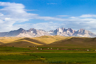
The central Afghan highlands, or the Afghan Highlands, is a geographic region of Afghanistan. Stretching from the Sabzak Pass near Herat in the west to the Little Pamir in the northeast, it includes the main Hindu Kush range and forms a western extension of the Himalayas. It is a highland area of more than 1,500 m above sea level, mostly situated between 2,000 and 3,000 m, with some peaks rising above 6,400 m. Usually, the valley bottoms in the area are used for cereal and horticultural production, and the mountains and high plateaus are used as pasture in summer for grazing sheep, goats, cattle, and camels. Its total area is about 414,000 km2.
, as Afghan President Ashraf Ghani has noted, Afghanistan is itself a Central Asian country.
{{cite book}}
: |website=
ignored (help)Afghanistan has abundant water resources. It produces 80 billion cubic meters of water a year, pumping 60 billion cubic meters of it to the neighbors — particularly Pakistan.