Continent | Asia |
---|---|
Region | Middle East |
Coordinates | 24°N54°E / 24°N 54°E |
Area | Ranked 114th |
• Total | 83,600 km2 (32,300 sq mi) |
• Land | 100% |
• Water | 0% |
Coastline | 1,318 km (819 mi) |
Borders | total: 867 km (539 mi) |
Highest point | Jabal ar Rahrah 1,691 m (5,548 ft) [1] |
Lowest point | Persian Gulf 0 m |
Longest river | None |
Largest lake | Lake Zakher |
Climate | arid; mild, pleasant winters; very hot, humid summers |
Terrain | mountainous and barren desert covered with loose sand and gravel |
Natural resources | petroleum, natural gas, marine resources |
Natural hazards | haze, dust storms, sandstorms common |
Environmental issues | limited natural freshwater resources are increasing dependence on large-scale desalination facilities |
Exclusive economic zone | 58,218 km2 (22,478 sq mi) |
The United Arab Emirates is situated in the Middle East and West Asia, bordering the Gulf of Oman and the Persian Gulf, between Oman and Saudi Arabia; it is at a strategic location along the northern approaches to the Strait of Hormuz, a vital transit point for world crude oil. [2] The UAE lies between 22°50′ and 26° north latitude and between 51° and 56°25′ east longitude. [3] It shares a 19 km (12 mi) border with Qatar on the northwest, a 530 km (330 mi) border with Saudi Arabia on the west, south, and southeast, and a 450 km (280 mi) border with Oman on the southeast and northeast. [3]
The land border with Qatar in the Khawr al Udayd area is a source of long-running dispute [3] (in fact, whether it even shares a land border with Qatar is in dispute). The total area of the UAE is approximately 83,600 square kilometres (32,300 square miles). [2] The country's exact size is unknown because of disputed claims to several islands in the Persian Gulf, because of the lack of precise information on the size of many of these islands, and because most of its land boundaries, especially with Saudi Arabia, remain undemarcated. [3] The largest emirate, Abu Dhabi, accounts for 87 percent of the UAE's total area (72,732 km2 (28,082 sq mi)). [3] The smallest emirate, Ajman, encompasses only 259 km2 (100 sq mi). [3]
The UAE stretches for more than 650 km (400 mi) along the southern shore of the Persian Gulf. [3] Most of the coast consists of salt pans that extend far inland. [3] A recent global remote sensing analysis suggested that there were 637 km2 of tidal flats in the United Arab Emirates, making it the 40th ranked country in terms of tidal flat extent. [4] The largest natural harbor is at Dubai, although other ports have been dredged at Abu Dhabi, Sharjah, and elsewhere. [3] Numerous islands are found in the Persian Gulf, and the ownership of some of them has been the subject of international disputes with both Iran and Qatar. [3] The smaller islands, as well as many coral reefs and shifting sandbars, are a menace to navigation. [3] Strong tides and occasional windstorms further complicate ship movements near the shore. [3]
These northern emirates on the Persian Gulf and Gulf of Oman are part of the Gulf of Oman desert and semi-desert ecoregion. [5]
South and west of Abu Dhabi, vast, rolling sand dunes merge into the Rub' al Khali (Empty Quarter) of Saudi Arabia. [3] The desert area of Abu Dhabi includes two important oases with adequate underground water for permanent settlements and cultivation. [3] The extensive Liwa Oasis is in the south near the undefined border with Saudi Arabia, and about 200 km (120 mi) to the northeast is Al Buraymi Oasis, which extends on both sides of the Abu Dhabi-Oman border. [3]
Prior to withdrawing from the area in 1971, Britain delineated the internal borders among the seven emirates in order to pre-empt territorial disputes that might hamper formation of the federation. [3] In general, the rulers of the emirates accepted the British intervention, but in the case of boundary disputes between Abu Dhabi and Dubai, and also between Dubai and Sharjah, conflicting claims were not resolved until after the UAE became independent. [3] The most complicated borders were in the Western Mountains, where five of the emirates contested jurisdiction over more than a dozen enclaves. [3]
The UAE also extends for about 90 km (56 mi) along the Gulf of Oman, an area known as Al-Batinah coast. [3] The Western Hajar Mountains (Jibāl Al-Ḥajar Al-Gharbī), rising in places to 2,500 m (8,200 ft), separate Al-Batinah coast from the rest of the UAE. [3] Beginning at the UAE-Oman border on the Persian Gulf coast of the Ras Musandam (Musandam Peninsula), the Western Mountains extend southeastward for about 150 km (93 mi) to the southernmost UAE-Oman frontier on the Gulf of Oman. [3] The range continues as the Eastern Hajar Mountains (Jibāl Al-Ḥajar Ash-Sharqī) for more than 500 km (310 mi) into Oman. [3] The steep mountain slopes run directly to the shore in many places. [3] Nevertheless, there are small harbors at Dibba Al-Hisn, Kalba, and Khor Fakkan on the Gulf of Oman. [3] In the vicinity of Fujairah, where the mountains do not approach the coast, there are sandy beaches. [3]
The climate of the UAE generally is very hot and sunny. [3] The hottest months are July and August, when average maximum temperatures reach above 48 °C (118.4 °F ) on the coastal plain. [3] In the Western Hajar Mountains, temperatures are considerably cooler, a result of increased altitude. [3] Average minimum temperatures in January and February are between 10 and 14 °C (50.0 and 57.2 °F). [3] During the late summer months, a humid southeastern wind known as the sharqi makes the coastal region especially unpleasant. [3] The average annual rainfall in the coastal area is less than 120 mm (4.7 in), but in some mountainous areas annual rainfall often reaches 350 mm (13.8 in). [3] Rain in the coastal region falls in short, torrential bursts during the summer months, sometimes resulting in floods in ordinarily dry wadi beds. [3] The region is prone to occasional, violent dust storms, which can severely reduce visibility. [3] The Jebel Jais mountain cluster in Ras Al Khaimah has experienced snow only four times (2004, 2009, 2017 and 2020) since records began. [6] [7]
Climate data for Dubai (1977–2015 normals) | |||||||||||||
---|---|---|---|---|---|---|---|---|---|---|---|---|---|
Month | Jan | Feb | Mar | Apr | May | Jun | Jul | Aug | Sep | Oct | Nov | Dec | Year |
Record high °C (°F) | 31.8 (89.2) | 37.5 (99.5) | 41.3 (106.3) | 43.5 (110.3) | 47.0 (116.6) | 47.9 (118.2) | 48.5 (119.3) | 48.8 (119.8) | 45.1 (113.2) | 42.4 (108.3) | 38.0 (100.4) | 33.2 (91.8) | 48.8 (119.8) |
Mean daily maximum °C (°F) | 23.9 (75.0) | 25.4 (77.7) | 28.9 (84.0) | 33.3 (91.9) | 37.7 (99.9) | 39.8 (103.6) | 40.9 (105.6) | 41.3 (106.3) | 38.9 (102.0) | 35.4 (95.7) | 30.6 (87.1) | 26.2 (79.2) | 33.5 (92.3) |
Daily mean °C (°F) | 19.1 (66.4) | 20.5 (68.9) | 23.6 (74.5) | 27.5 (81.5) | 31.4 (88.5) | 33.4 (92.1) | 35.5 (95.9) | 35.9 (96.6) | 33.3 (91.9) | 29.8 (85.6) | 25.4 (77.7) | 21.2 (70.2) | 28.1 (82.5) |
Mean daily minimum °C (°F) | 14.3 (57.7) | 15.5 (59.9) | 18.3 (64.9) | 21.7 (71.1) | 25.1 (77.2) | 27.3 (81.1) | 30.0 (86.0) | 30.4 (86.7) | 27.7 (81.9) | 24.1 (75.4) | 20.1 (68.2) | 16.3 (61.3) | 22.6 (72.6) |
Record low °C (°F) | 7.7 (45.9) | 7.4 (45.3) | 11.0 (51.8) | 13.7 (56.7) | 15.7 (60.3) | 21.3 (70.3) | 24.1 (75.4) | 24.0 (75.2) | 22.0 (71.6) | 15.0 (59.0) | 10.8 (51.4) | 8.2 (46.8) | 7.4 (45.3) |
Average precipitation mm (inches) | 18.8 (0.74) | 25.0 (0.98) | 22.1 (0.87) | 7.2 (0.28) | 0.4 (0.02) | 0.0 (0.0) | 0.8 (0.03) | 0.0 (0.0) | 0.0 (0.0) | 1.1 (0.04) | 2.7 (0.11) | 16.2 (0.64) | 94.3 (3.71) |
Average precipitation days | 5.5 | 4.7 | 5.8 | 2.6 | 0.3 | 0.0 | 0.5 | 0.5 | 0.1 | 0.2 | 1.3 | 3.8 | 25.3 |
Mean monthly sunshine hours | 251 | 241 | 270 | 306 | 350 | 345 | 332 | 326 | 309 | 307 | 279 | 254 | 3,570 |
Mean daily sunshine hours | 8.1 | 8.6 | 8.7 | 10.2 | 11.3 | 11.5 | 10.7 | 10.5 | 10.3 | 9.9 | 9.3 | 8.2 | 9.8 |
Source 1: Dubai Meteorological Office [8] | |||||||||||||
Source 2: UAE National Center of Meteorology [9] |
Climate data for Abu Dhabi | |||||||||||||
---|---|---|---|---|---|---|---|---|---|---|---|---|---|
Month | Jan | Feb | Mar | Apr | May | Jun | Jul | Aug | Sep | Oct | Nov | Dec | Year |
Record high °C (°F) | 33.7 (92.7) | 38.1 (100.6) | 43.0 (109.4) | 44.7 (112.5) | 46.9 (116.4) | 48.8 (119.8) | 52.7 (126.9) | 49.2 (120.6) | 47.7 (117.9) | 43.0 (109.4) | 38.0 (100.4) | 33.4 (92.1) | 52.7 (126.9) |
Mean daily maximum °C (°F) | 24.1 (75.4) | 26.0 (78.8) | 29.5 (85.1) | 34.5 (94.1) | 39.3 (102.7) | 40.8 (105.4) | 42.1 (107.8) | 42.7 (108.9) | 40.4 (104.7) | 36.5 (97.7) | 31.1 (88.0) | 26.3 (79.3) | 34.4 (94.0) |
Daily mean °C (°F) | 18.8 (65.8) | 19.6 (67.3) | 22.6 (72.7) | 26.4 (79.5) | 31.2 (88.2) | 33.0 (91.4) | 34.9 (94.8) | 35.3 (95.5) | 32.7 (90.9) | 29.1 (84.4) | 24.5 (76.1) | 20.8 (69.4) | 27.4 (81.3) |
Mean daily minimum °C (°F) | 13.2 (55.8) | 14.6 (58.3) | 17.5 (63.5) | 20.8 (69.4) | 23.8 (74.8) | 26.1 (79.0) | 28.8 (83.8) | 29.5 (85.1) | 26.6 (79.9) | 23.2 (73.8) | 18.7 (65.7) | 15.8 (60.4) | 21.5 (70.8) |
Record low °C (°F) | 8.0 (46.4) | 5.0 (41.0) | 8.4 (47.1) | 11.2 (52.2) | 16.0 (60.8) | 19.8 (67.6) | 22.2 (72.0) | 23.8 (74.8) | 19.0 (66.2) | 12.0 (53.6) | 10.5 (50.9) | 7.1 (44.8) | 5.0 (41.0) |
Average precipitation mm (inches) | 7.0 (0.28) | 21.2 (0.83) | 14.5 (0.57) | 6.1 (0.24) | 1.3 (0.05) | 0 (0) | 0 (0) | 1.5 (0.06) | 0 (0) | 0 (0) | 0.3 (0.01) | 5.2 (0.20) | 57.1 (2.24) |
Average precipitation days (≥ 0.2 mm) | 1.2 | 2.8 | 2.8 | 1.2 | 0.1 | 0.0 | 0.0 | 0.1 | 0.0 | 0.0 | 0.2 | 1.5 | 9.9 |
Average relative humidity (%) | 68 | 67 | 63 | 58 | 55 | 60 | 61 | 63 | 64 | 65 | 65 | 68 | 63 |
Average dew point °C (°F) | 12 (54) | 12 (54) | 12 (54) | 14 (57) | 16 (61) | 20 (68) | 22 (72) | 21 (70) | 22 (72) | 19 (66) | 16 (61) | 13 (55) | 17 (62) |
Mean monthly sunshine hours | 246.1 | 232.6 | 251.1 | 280.5 | 342.2 | 336.9 | 314.2 | 307.5 | 302.4 | 304.7 | 286.6 | 257.6 | 3,462.4 |
Source 1: NOAA (1971–1991) [10] | |||||||||||||
Source 2: Climate Yearly Report (2003-2020) [11] Source 3: Time and Date (dewpoints, between 2005-2015) [12] |
Date palms, as well as acacia and eucalyptus trees, are commonly found growing at the region's oases. Within the desert itself, the flora is much more sparse and primarily consists of grasses and thornbushes.
The region's indigenous fauna had previously come close to extinction due to intensive hunting, which led to a 1970s conservation program on the Bani Yas island by Sheikh Zayed bin Sultan Al Nahyan; this resulted in the survival of Arabian oryxes and leopards, among others. [13] The region's coastal fish consist mainly of mackerel, perch and tuna, as well as sharks and whales.
Area:
Land boundaries:
Coastline: 1,318 km (819 mi) [2]
Maritime claims:
Elevation extremes:
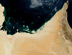
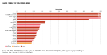
Oman is a country on the southeast coast of the Arabian Peninsula, situated in West Asia, bordering the Arabian Sea, Gulf of Oman, and Persian Gulf, between Yemen and the United Arab Emirates (UAE). The coast of Oman was an important part in the Omani empire and sultanate.
The United Arab Emirates is a country in the eastern part of the Arabian Peninsula located on the southeastern coast of the Persian Gulf and the northwestern coast of the Gulf of Oman. The UAE consists of seven emirates and was founded on 2 December 1971 as a federation, after UK armed forces left the region. Six of the seven emirates declared their union on 2 December 1971. The seventh, Ras al Khaimah, joined the federation on 10 February 1972. The seven sheikdoms were formerly known as the Trucial States, in reference to the truce treaties established with the British in the 19th century.
The United Arab Emirates (UAE), or simply the Emirates, is a country in West Asia, in the Middle East. Located at the eastern end of the Arabian Peninsula, it shares borders with Oman and Saudi Arabia; as well as maritime borders in the Persian Gulf with Qatar and Iran. The United Arab Emirates is an elective monarchy formed from a federation of seven emirates. As of 2023, the UAE has an estimated population of 9.97 million. Emirati citizens are estimated to form 11.6% of the population; the remaining residents are expatriates, the majority of whom are South Asian. Islam is the official religion and Arabic is the official language. Abu Dhabi is the country's capital, while Dubai, the most populous city, is an international hub.
Al Ain is a border city on the eastern side of Tawam oasis and the seat of the administrative division, the Al Ain Region, in the Emirate of Abu Dhabi, United Arab Emirates. The city is bordered to the east by the Omani town of Al-Buraimi in the Al Buraimi Governorate. It is the largest inland city in the Emirates, the fourth-largest city, and the second-largest in the Emirate of Abu Dhabi. The freeways connecting Al-Ain, Abu Dhabi, and Dubai form a geographic triangle in the country, each city being roughly 130 kilometres (81 mi) from the other two.
E 11 is a highway in the United Arab Emirates (UAE). The longest road in the Emirates, it stretches from the Al Batha border crossing at the Saudi Arabia–UAE border in al-Silah in the al-Dhafra region of the Emirate of Abu Dhabi and ends at the Oman–UAE border crossing of al-Darah in al-Jeer, Emirate of Ras al-Khaimah, running roughly parallel to UAE's coastline along the Persian Gulf. The road forms the main artery in some emirates' main cities, where it assumes various alternate names —Sheikh Maktoum Bin Rashid Road and Sheikh Khalifa bin Zayed Road in Abu Dhabi, Sheikh Zayed Road in Dubai, Al Ittihad Road in Sharjah Emirate and Ajman Emirate, and Sheikh Muhammad bin Salem Road in Ras al-Khaimah.
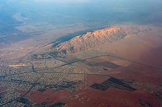
Jabal Hafeet is a mountain in the region of Tawam, on the border of the United Arab Emirates and Oman, which may be considered an outlier of the Hajar Mountains in Eastern Arabia. Due to its proximity to the main Hajar range, the mountain may be considered as being part of the Hajar range. To the north is the UAE city of Al Ain, in the Eastern Region of the Emirate of Abu Dhabi, and the adjacent Omani town of Al-Buraimi.
Al Buraimi Governorate is one of the 11 governorates of Oman. The area was part of Ad Dhahirah Region until October 2006, when a new governorate was created from the Wilayats (Provinces) of Al Buraymi and Mahdah. A third wilayat, As-Sunaynah, was created from parts of the two. Dr. Hamad bin Ahmed Al Busaidi has been governor since 2020.
Wadi Wurayah is a 12,700-hectare (31,000-acre) wadi between the towns of Masafi, Khor Fakkan, and Bidiyah in the United Arab Emirates. It has been designated as Ramsar Wetland of International Importance.
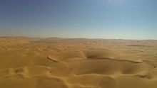
The Gulf of Oman desert and semi-desert is a coastal ecoregion on the Persian Gulf and the Gulf of Oman in Oman and the United Arab Emirates at the northeastern tip of the Arabian Peninsula. The climate is hot and dry, with gravelly plains and savanna with thorny acacia trees inland from the coast. Along the coast there are mixture of habitats that include mangrove swamps, lagoons and mudflats. The mangrove areas are dominated by Avicennia marina and the savanna by Prosopis cineraria and Vachellia tortilis. Masirah Island is an important breeding area for the loggerhead sea turtle and other sea turtles also occur here, as well as a great variety of birds, some resident and some migratory. There are some protected areas, but in general the habitats have been degraded by the grazing of livestock, especially camels and goats; they are also at risk from oil spills, off-road driving and poaching.
The military history of the United Arab Emirates describes the military history of the United Arab Emirates Armed Forces. Prior to the union of the emirates, different tribal confederations formed the de facto military force which was dominant in the area now known as the United Arab Emirates. The Bani Yas and Al Qawasim were the most significant of those tribal confederations. The official formation of the military began with the formation of the Truical Oman Levies by the British Empire on 11 May 1951 as the area was under a British protectorate.
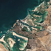
Dubai is situated on the Persian Gulf coast of the United Arab Emirates and is roughly at sea level. The emirate of Dubai shares borders with Abu Dhabi in the south, Sharjah in the northeast, and the Sultanate of Oman in the. Hatta, a minor exclave of the emirate, is surrounded on three sides by Oman and by the emirates of Ajman and Ras Al Khaimah. The Persian Gulf borders the western coast of the emirate. Dubai is positioned at 25.2697°N 55.3095°E and covers an area of 1,588 sq mi (4,110 km2), which represents a significant expansion beyond its initial 1,500 sq mi (3,900 km2) designation due to land reclamation from the sea.
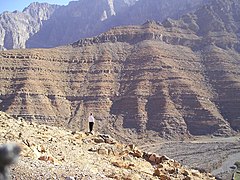
The Hajar Mountains are one of the highest mountain ranges in the Arabian Peninsula, shared between northern Oman and eastern United Arab Emirates. Also known as "Oman Mountains", they separate the low coastal plain of Oman from the high desert plateau, and lie 50–100 km (31–62 mi) inland from the Gulf of Oman.
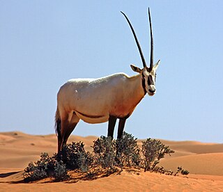
The wildlife of the United Arab Emirates is the flora and fauna of the country on the eastern side of the Arabian Peninsula and the southern end of the Persian Gulf. The country offers a variety of habitats for wildlife including the coast, offshore islands, mangrove areas, mudflats, salt pans, sand and gravel plains, sand dunes, mountain slopes, wadis and rocky summits. Because the terrain is so varied, it supports a greater number of species of plants and animals than might be expected in a small country.
The geology of the United Arab Emirates includes very thick Paleozoic, Mesozoic and Cenozoic marine and continental sedimentary rocks overlying deeply buried Precambrian. The region has extensive oil and gas resources and was deformed during the last several million years by more distant tectonic events.
Tawam, also Tuwwam, Tu'am, or "Al-Buraimi Oasis", is a historical oasis region in Eastern Arabia that stretched from, or was located between, the Western Hajar Mountains to the Persian Gulf coast, nowadays forming parts of the United Arab Emirates and western Oman. It is marked by the twin settlements of Al Ain and Al-Buraimi on the UAE-Omani border.
Mezyad is a settlement in the Eastern Region of the Emirate of Abu Dhabi, to the south of the main part of Al Ain City, on the border of the U.A.E. and Oman. It is known for having a historical fort, and is part of a desert park, which also includes a necropolis and Mount Hafeet nearby. The park can be called either "Mezyad Desert Park" or "Jebel Hafeet Desert Park".
The Saudi Arabia–United Arab Emirates border is 457 km (284 mi) in length and runs from the Persian Gulf coast in the west to the tripoint with Oman in the east.
Al Hajar montane woodlands is a temperate grasslands, savannas and shrublands ecoregion in the Hajar Mountains of the eastern part of the Arabian Peninsula, which extends across portions of Oman and the U.A.E.
{{cite encyclopedia}}
: CS1 maint: postscript (link)