Geography of Trinidad and Tobago

Last updated

Geography of Trinidad and Tobago
Trinidad Topography.png
Region Caribbean
Coordinates 11°00′N61°00′W / 11.000°N 61.000°W / 11.000; -61.000
Area
  Total5,128 km2 (1,980 sq mi)
Coastline362 km (225 mi)
Highest point El Cerro del Aripo
940 m
Map of Trinidad and Tobago Td-map.gif
Map of Trinidad and Tobago

Trinidad and Tobago is an archipelagic republic in the southern Caribbean between the Caribbean Sea and the North Atlantic Ocean, northeast of Venezuela. They are southeasterly islands of the Lesser Antilles, Monos, Huevos, Gaspar Grande (or Gasparee), Little Tobago, and St. Giles Island. Trinidad is 11 km (6.8 mi) off the northeast coast of Venezuela and 130 km (81 mi) south of the Grenadines.[ citation needed ] The island measures 4,768 km2 (1,841 sq mi) in area (comprising 93.0% of the country's total area) with an average length of 80 km (50 mi) and an average width of 59 km (37 mi).[ citation needed ] The island appears rectangular in shape with three projecting peninsular corners. [1] Tobago is 30 km (19 mi) northeast of Trinidad and measures about 298 km2 (115 sq mi) in area, or 5.8% of the country's area, 41 km (25.5 mi) in length and 12 km (7.5 mi) at its greatest width.[ citation needed ] The island is cigar-shaped in appearance, with a northeast–southwest alignment.

Contents

Physical geography

Trinidad is traversed by three distinct mountain ranges that are a continuation of the Venezuelan coastal cordillera. [1] The Northern Range, an outlier of the Andes Mountains of Venezuela, consists of rugged hills that parallel the coast. [1] This range rises into two peaks. [1] The highest, El Cerro del Aripo, is 940 metres (3,084 ft) high; the other, El Tucuche, reaches 936 metres (3,071 ft). [1] The Central Range extends diagonally across the island and is a low-lying range with swampy areas rising to rolling hills; its maximum elevation is 325 metres (1,066 ft). [1] The Caroni Plain, composed of alluvial sediment, extends southward, separating the Northern Range and Central Range. [1] The Southern Range consists of a broken line of hills with a maximum elevation of 305 metres (1,001 ft). [1]

There are numerous rivers and streams on the island of Trinidad; the most significant are the Ortoire River, 50 kilometres (31.1 mi) long, which extends eastward into the Atlantic, and the 40-kilometre (24.9 mi)-long Caroni River, reaching westward into the Gulf of Paria. [1] Most of the soils of Trinidad are fertile, with the exception of the sandy and unstable terrain found in the southern part of the island. [1]

Tobago is mountainous and dominated by the Main Ridge, which is 29 kilometres (18 mi) long with elevations up to 550 meters. [1] There are deep, fertile valleys running north and south of the Main Ridge. [1] The southwestern tip of the island has a coral platform. [1] Although Tobago is volcanic in origin, there are no active volcanoes. [1] Forestation covers 43% of the island. [1] There are numerous rivers and streams, but flooding and erosion are less severe than in Trinidad. [1] The coastline is indented with numerous bays, beaches, and narrow coastal plains. [1]

Tobago has several small satellite islands. [1] The largest of these, Little Tobago, is starfish shaped, hilly, and 1.2 km2 (0.46 sq mi). [1]

Because it was once part of continental South America, Trinidad has an assortment of tropical vegetation and wildlife considerably more varied than that of most Caribbean islands. [1] Tobago has a generally similar but less varied assortment. [1]

Geology

Geologically, the islands are not part of the Lesser Antilles Volcanic Arc. [1] Rather, Trinidad was once part of the South American mainland and is situated on its continental shelf, and Tobago is part of a sunken island arc chain related to the Pacific-derived Caribbean Plate. [1] The islands are separated from the continent of South America by the Gulf of Paria; Bocas del Dragón, a 19-kilometre (11.8 mi)-wide northern passage; and Serpent's Mouth, a 14-kilometre (8.7 mi)-wide southern passage. [1]

The Northern Range consists mainly of Upper Jurassic and Cretaceous metamorphic rocks. [2] The Northern Lowlands (East–West Corridor and Caroni Plains) consist of younger shallow marine clastic sediments.[ citation needed ] South of this, the Central Range fold and thrust belt consists of Cretaceous and Eocene sedimentary rocks, with Miocene formations along the southern and eastern flanks.[ citation needed ] The Naparima Plains and the Nariva Swamp form the southern shoulder of this uplift.[ citation needed ]

The Southern Lowlands consist of Miocene and Pliocene sands, clays, and gravels.[ citation needed ] These overlie oil and natural gas deposits, especially north of the Los Bajos Fault.[ citation needed ] The Southern Range forms the third anticlinal uplift.[ citation needed ] It consists of several chains of hills, most famous being the Trinity Hills.[ citation needed ] The rocks consist of sandstones, shales, siltstones and clays formed in the Miocene and uplifted in the Pleistocene.[ citation needed ] Oil sands and mud volcanoes are especially common in this area.[ citation needed ]

Political geography

Regional corporations and municipalities of Trinidad and Tobago Regional corporations and municipalities of Trinidad and Tobago.svg
Regional corporations and municipalities of Trinidad and Tobago

Trinidad is split into 14 regional corporations and municipalities, consisting of 9 regions and 5 municipalities, which have a limited level of autonomy.[ citation needed ] The various councils are made up of a mixture of elected and appointed members. Elections are due to be held every three years with the last elections held in 2019.[ citation needed ] The island of Tobago is administered by the Tobago House of Assembly.[ citation needed ]

Climate

Koppen climate map of the islands of the West Indies, with the climate of Trinidad and Tobago visible in the southeast corner. Koppen-Geiger Map Caribbean present.svg
Köppen climate map of the islands of the West Indies, with the climate of Trinidad and Tobago visible in the southeast corner.

The country lies in the tropics, enjoying a generally pleasant maritime tropical climate influenced by the northeast trade winds. [1] In Trinidad the annual mean temperature is 26 °C (78.8 °F), and the average maximum temperature is 34 °C (93.2 °F). [1] The highest temperature ever was 37.8 degrees Celsius. The lowest (coldest felt) temperature recorded in Trinidad was 16.1 °C (61.0 °F) in January 1964.[ citation needed ] The humidity is high, particularly during the rainy season, when it averages 85 to 87%. [1] The island receives an average of 2,110 millimeters (83.1 in) of rainfall per year, usually concentrated in the months of June through December, when brief, intense showers frequently occur. [1] Precipitation is highest in the Northern Range, which may receive as much as 3,810 millimeters (150 in). [1] During the dry season, drought plagues the island's central interior. [1] Tobago's climate is similar to Trinidad's but slightly cooler. [1] Its rainy season extends from June to December; the annual rainfall is 2,500 millimeters (98.4 in). [1] The islands lie outside the hurricane belt; [1] [3] despite this, Hurricane Flora damaged Tobago in 1963. The hurricane killed 18 people on Tobago and caused $30:million in crop and property damages (1963 USD). [4] Tropical Storm Alma hit Trinidad in 1974, causing damage before reaching full strength. [1] Wind gusts reached 91 mph (147 km/h) at the Savonette gas field during the storm. [5]

Climate data for Port of Spain
MonthJanFebMarAprMayJunJulAugSepOctNovDecYear
Record high °C (°F)33.2
(91.8)
33.0
(91.4)
34.9
(94.8)
34.9
(94.8)
35.3
(95.5)
34.4
(93.9)
33.5
(92.3)
34.2
(93.6)
37.0
(98.6)
35.5
(95.9)
33.8
(92.8)
33.2
(91.8)
37.0
(98.6)
Mean daily maximum °C (°F)28.0
(82.4)
28.9
(84.0)
30.3
(86.5)
31.0
(87.8)
33.1
(91.6)
31.5
(88.7)
31.3
(88.3)
31.7
(89.1)
32.2
(90.0)
32.2
(90.0)
31.5
(88.7)
31.1
(88.0)
31.1
(87.9)
Mean daily minimum °C (°F)17.0
(62.6)
19.2
(66.6)
20.7
(69.3)
22.0
(71.6)
23.0
(73.4)
23.3
(73.9)
23.0
(73.4)
23.0
(73.4)
23.1
(73.6)
22.6
(72.7)
22.3
(72.1)
21.0
(69.8)
21.7
(71.0)
Record low °C (°F)14.6
(58.3)
16.1
(61.0)
16.7
(62.1)
17.2
(63.0)
18.9
(66.0)
19.7
(67.5)
18.3
(64.9)
18.9
(66.0)
19.4
(66.9)
19.4
(66.9)
17.9
(64.2)
15.7
(60.3)
14.6
(58.3)
Average rainfall mm (inches)42.9
(1.69)
39.8
(1.57)
16.9
(0.67)
27.7
(1.09)
67.5
(2.66)
155.6
(6.13)
193.6
(7.62)
244.0
(9.61)
190.5
(7.50)
143.3
(5.64)
210.5
(8.29)
75.7
(2.98)
1,408
(55.43)
Average rainy days (≥ 0.1 mm)1110661120211916151813166
Average relative humidity (%)81807777798484848485868482
Mean monthly sunshine hours 241.3231.3248.3237.5233.2183.7205.9212.5197.1207.4197.7214.52,610.4
Source 1: World Meteorological Organization [6]
Source 2: NOAA (sun, extremes and humidity) [7]
Climate data for Scarborough, Tobago
MonthJanFebMarAprMayJunJulAugSepOctNovDecYear
Mean daily maximum °C (°F)29
(85)
30
(86)
31
(87)
31
(88)
31
(88)
31
(87)
30
(86)
31
(87)
31
(87)
31
(87)
30
(86)
29
(85)
30
(86)
Mean daily minimum °C (°F)22
(72)
22
(72)
23
(73)
24
(75)
24
(76)
24
(76)
24
(75)
24
(75)
24
(75)
24
(75)
23
(74)
23
(73)
23
(74)
Average precipitation mm (inches)48
(1.9)
48
(1.9)
43
(1.7)
46
(1.8)
64
(2.5)
150
(5.8)
190
(7.4)
160
(6.4)
170
(6.7)
220
(8.7)
210
(8.1)
160
(6.3)
1,505
(59.27)
Source: Weatherbase [8]
Climate data for San Fernando
MonthJanFebMarAprMayJunJulAugSepOctNovDecYear
Mean daily maximum °C (°F)29.3
(84.7)
29.7
(85.5)
30.3
(86.5)
31.2
(88.2)
31.0
(87.8)
30.2
(86.4)
30.1
(86.2)
30.6
(87.1)
31.1
(88.0)
30.9
(87.6)
30.6
(87.1)
29.8
(85.6)
30.4
(86.7)
Daily mean °C (°F)25.0
(77.0)
25.0
(77.0)
25.6
(78.1)
26.5
(79.7)
26.9
(80.4)
26.3
(79.3)
26.2
(79.2)
26.4
(79.5)
26.7
(80.1)
26.6
(79.9)
26.3
(79.3)
25.5
(77.9)
26.1
(79.0)
Mean daily minimum °C (°F)20.7
(69.3)
20.4
(68.7)
20.9
(69.6)
21.8
(71.2)
22.8
(73.0)
22.5
(72.5)
22.4
(72.3)
22.3
(72.1)
22.4
(72.3)
22.4
(72.3)
22.0
(71.6)
21.2
(70.2)
21.8
(71.3)
Average rainfall mm (inches)77
(3.0)
42
(1.7)
43
(1.7)
56
(2.2)
84
(3.3)
193
(7.6)
214
(8.4)
235
(9.3)
182
(7.2)
157
(6.2)
184
(7.2)
132
(5.2)
1,599
(63)
Source: Climate-data.org [9]

Statistics

Trinidad and Tobago (orthographic projection).svg
Enlargeable comprehensive map TrinidadAndTobago2021OSM.png
Enlargeable comprehensive map

Area:
total: 5,128 km2 [3]
land: 5,128 km2 [3]
water: negligible [3]

Coastline: 362 km [3]

Maritime claims:
contiguous zone:24  nmi (44.4 km; 27.6 mi) [3]
continental shelf:200 nmi (370.4 km; 230.2 mi) or to the outer edge of the continental margin [3]
exclusive economic zone:200 nmi (370.4 km; 230.2 mi) [3]
territorial sea:12 nmi (22.2 km; 13.8 mi) [3]

Terrain: mostly plains with some hills and low mountains [3]

Extreme points:

Northernmost point: Marble Island, Tobago [ citation needed ]

Southernmost point: Icacos, Siparia region, Trinidad Island [ citation needed ]

Westernmost point: Icacos, Siparia region, Trinidad Island [ citation needed ]

Easternmost point: Easternmost tip of Little Tobago, Tobago [ citation needed ]

Lowest point: Caribbean Sea 0 m[ citation needed ]

Highest point: El Cerro del Aripo, Trinidad 940 m[ citation needed ]

Natural resources: petroleum, natural gas, asphalt [3]

Land use:
arable land: 4.9%
permanent crops: 4.3%

permanent pasture: 1.4%

forest: 44%
other: 45.4% (2018 est.) [3]

Irrigated land: 70 km2 (2012) [3]

Total renewable water resources: 3.84 billion m³ (2017) [3]

See also

Related Research Articles

<span class="mw-page-title-main">Geography of the Dominican Republic</span>

The Dominican Republic is a country in the West Indies that occupies the eastern five-eighths of Hispaniola. It has an area of 48,670 km2, including offshore islands. The land border shared with Haiti, which occupies the western three-eighths of the island, is 376 km long. The maximum length, east to west, is 390 km from Punta de Agua to Las Lajas, on the border with Haiti. The maximum width, north to south, is 265 km from Cape Isabela to Cape Beata. The capital, Santo Domingo, is located on the south coast.

<span class="mw-page-title-main">Geography of Grenada</span> Geography of Grenada

Grenada is an island country located between the Caribbean Sea and Atlantic Ocean, north of Trinidad and Tobago. It is located at 12°07′N61°40′W. There are no large inland bodies of water on the island, which consists entirely of the state of Grenada. The coastline is 121 km long. The island has 15 constituencies and speaks English and Grenadian Creole. It is volcanic in origin and its topography is mountainous.

<span class="mw-page-title-main">Geography of Haiti</span>

The Republic of Haiti comprises the western three-eighths of the island of Hispaniola, west of the Dominican Republic. Haiti is positioned east of the neighboring island of Cuba, between the Caribbean Sea and the North Atlantic Ocean.

<span class="mw-page-title-main">Geography of Thailand</span>

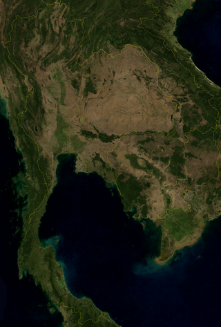
Thailand is in the middle of mainland Southeast Asia. It has a total size of 513,120 km2 (198,120 sq mi) which is the 50th largest in the world. The land border is 4,863 km (3,022 mi) long with Myanmar, Cambodia, Laos and Malaysia. The nation's axial position influenced many aspects of Thailand's society and culture. It controls the only land route from Asia to Malaysia and Singapore. It has an exclusive economic zone of 299,397 km2 (115,598 sq mi).

<span class="mw-page-title-main">Geography of Venezuela</span> Geography of Venezuela

Venezuela is a country in South America, bordering the Caribbean Sea and the North Atlantic Ocean, between Colombia and Guyana. It is situated on major sea and air routes linking North and South America. Located at the northernmost end of South America, Venezuela has a total area of 912,050 km2 (352,140 sq mi) and a land area of 882,050 km2 (340,560 sq mi). It is the 32nd largest country and is slightly smaller than Egypt, or half the size of Mexico. Shaped roughly like an inverted triangle, the country has a 2,800 km (1,700 mi) long coastline. It is bound on the north by the Caribbean Sea and the Atlantic Ocean, on the east by Guyana, on the south by Brazil, and on the west by Colombia. It has the 55th largest Exclusive Economic Zone of 471,507 km2 (182,050 sq mi). Its maritime territory borders Trinidad and Tobago, Dominica, the Dominican Republic, Grenada, St. Kitts and Nevis, St. Vincent and the Grenadines, France, the United Kingdom, the Netherlands, and the United States. Venezuela also claims the region of Guayana Esequiba, currently under the control of Guyana.

The Geography of Guyana comprises the physical characteristics of the country in Northern South America and part of Caribbean South America, bordering the North Atlantic Ocean, between Suriname and Venezuela, with a land area of approximately 214,969 square km. The country is situated between 1 and 9 north latitude and between 56 and 62 west longitude. With a 459 km (285 mi)-long Atlantic coastline on the northeast, Guyana is bounded by Venezuela on the west, Brazil on the west and south, and Suriname on the east.

<span class="mw-page-title-main">Geography of Barbados</span> Geography of Barbados

Barbados is a continental island in the North Atlantic Ocean and is located at 13°10' north of the equator, and 59°32' west of the Prime Meridian. As the easternmost isle of the Lesser Antilles in the West Indies, Barbados lies 160 kilometres (100 mi) east of the Windward Islands and Caribbean Sea. The maritime claim for Barbados is a territorial sea of 12 nmi, with an exclusive economic zone of 200 nmi which gives Barbados a total maritime area of 186,898 km2 (72,162 sq mi). Of the total EEZ area, 70,000 km2 is set aside for offshore oil exploration. A pending application to UNCLOS has placed for consideration a continental shelf 200 nmi to the east and south. To the west, most of Barbados' maritime boundaries consist of median lines with neighbours. These neighbours include: Martinique, and Saint Lucia to the northwest, Saint Vincent and the Grenadines to the west, Trinidad and Tobago and Venezuela to the southwest, and Guyana to the southeast.

<span class="mw-page-title-main">Tobago</span> Autonomous island in the Republic of Trinidad and Tobago

Tobago is an island and ward within the Republic of Trinidad and Tobago. It is located 35 kilometres (22 mi) northeast of the larger island of Trinidad and about 160 kilometres (99 mi) off the northeastern coast of Venezuela. It lies to the southeast of Grenada.

<span class="mw-page-title-main">Trinidad</span> Largest island of Trinidad and Tobago

Trinidad is the larger and more populous of the two major islands of Trinidad and Tobago. The island lies 11 km (6.8 mi) off the northeastern coast of Venezuela and sits on the continental shelf of South America. It is often referred to as the southernmost island in the West Indies. With an area of 4,768 km2 (1,841 sq mi), it is also the fifth largest in the West Indies.

<span class="mw-page-title-main">Gulf of Paria</span> A shallow semi-enclosed inland sea between the island of Trinidad and the east coast of Venezuela

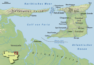
The Gulf of Paria is a 7,800 km2 (3,000 sq mi) shallow semi-enclosed inland sea located between the island of Trinidad and the east coast of Venezuela. It separates the two countries by as little as 15 km at its narrowest and 120 km at its widest points. The tides within the Gulf are semi-diurnal in nature with a range of approximately 1m. The Gulf of Paria is considered to be one of the best natural harbors on the Atlantic coast of the Americas. The jurisdiction of the Gulf of Paria is split between Trinidad and Venezuela with Trinidad having control over approximately 2,940 km2 (1,140 sq mi) (37.7%) and Venezuela the remainder (62.3%).

<span class="mw-page-title-main">Northern Range</span>

The Northern Range is the range of tall hills across north Trinidad, the major island in the Republic of Trinidad and Tobago. The hills range from the Chaguaramas peninsula on the west coast to Toco in the east. The Northern Range covers approximately twenty-five percent of the land area of Trinidad.

El Cerro del Aripo, at 940 metres (3,084 ft), is the highest point in the Republic of Trinidad and Tobago. It is part of the Aripo Massif and is located in the Northern Range on the island of Trinidad, northeast of the town of Arima.

<span class="mw-page-title-main">Caroni River (Trinidad and Tobago)</span> River in Trinidad and Tobago

The Caroni River is the largest river in Trinidad and Tobago, running for 40 km (25 mi) from its origins in the Northern Range on the island of Trinidad, through the northern lowlands of the Caroni Plains and enters the Gulf of Paria at the Caroni Swamp.

<span class="mw-page-title-main">Saint George County</span>

Saint George is a county in Trinidad and Tobago. It occupies the northwestern portion of the island of Trinidad and is bounded by the Caribbean Sea to the north, the Gulf of Paria to the west, Caroni County to the south and Saint David County and Saint Andrew County to the east. It occupies an area of 912 km2 (352 sq mi). The county includes the Bocas Islands and the towns of Port of Spain and Arima. It also includes the small town of Blanchisseuse and its attractive beach, backed by a forest-fringed lagoon. County Saint George is divided into six Wards: Diego Martin, Saint Ann's, Blanchisseuse, Tacarigua, Arima and San Raphael.

<span class="mw-page-title-main">Trinidad and Tobago</span> Country in the Caribbean

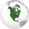
Trinidad and Tobago, officially the Republic of Trinidad and Tobago, is the southernmost island country in the Caribbean. Consisting of the main islands Trinidad and Tobago and numerous much smaller islands, it is situated 11 kilometres off the coast of northeastern Venezuela and 130 kilometres south of Grenada. It shares maritime boundaries with Barbados to the east, Grenada to the northwest and Venezuela to the south and west. Trinidad and Tobago is generally considered to be part of the West Indies. The island country's capital is Port of Spain, while its largest and most populous municipality is Chaguanas.

<span class="mw-page-title-main">Tunapuna–Piarco</span> Region

Tunapuna–Piarco is one of the 9 regions of Trinidad and Tobago. It is the most populous region in the country by total population and the fifth-largest by total land area. Geographically located in Northern Trinidad, Tunapuna–Piarco shares its borders with the regions of San Juan–Laventille to the west, Couva–Tabaquite–Talparo to the south, the Borough of Chaguanas to the south-west, Sangre Grande to the east and the Caribbean Sea to the north. The region also completely surrounds the Royal Chartered Borough of Arima, which is located in the south-eastern corner of the region.

<span class="mw-page-title-main">Outline of Trinidad and Tobago</span> Overview of and topical guide to Trinidad and Tobago

The following outline is provided as an overview of and topical guide to Trinidad and Tobago:

<span class="mw-page-title-main">Caroni Plain</span>

On the island of Trinidad in the Republic of Trinidad and Tobago, the Caroni Plain is a lowland area between the Northern Range and the Central Range. The lowland areas to the south of the Central Range are the Naparima Plain on the west and the Nariva Plain on the east. The lowland areas are either flat or consist of gently rolling hills. The 25-mile long Caroni river flows westward through the Caroni Plain and drains into the Caroni Swamp on the Gulf of Paria coast. The Caroni Plain was a major region of sugar and cocoa production in the 18th and 19th centuries and the first half of the 20th century.

<span class="mw-page-title-main">Trinidad and Tobago moist forests</span>

The Trinidad and Tobago moist forests ecoregion covers most of Trinidad Island and Tobago Island near the coast of South America where the southeastern Caribbean Sea meets the Atlantic Ocean. Small portions of the islands around river estuaries and coastal lowlands are mangroves or dry forests. Species diversity is very high, in particular for plants and birds. Tobago, being much smaller, has fewer species.

References

  1. 1 2 3 4 5 6 7 8 9 10 11 12 13 14 15 16 17 18 19 20 21 22 23 24 25 26 27 28 29 30 31 32 33 34 Meyerson, Beatrice Berle; Seyler, Daniel J.; Hornbeck, John F. (1987). "Trinidad and Tobago: Geography". In Meditz, Sandra W.; Hanratty, Dennis M. (eds.). Islands of the Commonwealth Caribbean: a regional study. Washington, D.C.: Federal Research Division, Library of Congress. pp. 174–177. OCLC   49361510. PD-icon.svg This article incorporates text from this source, which is in the public domain.{{cite encyclopedia}}: CS1 maint: postscript (link)
  2. Paleogeographic Evolution and Non-Glacial Eustacy, Northern South America. SEPM (Society for Sedimentary Geology). 1998. doi:10.2110/pec.98.58.0087. ISBN   978-1-56576-041-7. S2CID   131385286.
  3. 1 2 3 4 5 6 7 8 9 10 11 12 13 14 "Trinidad and Tobago". World Factbook . Central Intelligence Agency. May 3, 2021. Retrieved May 13, 2021.
  4. C. B. Daniel; R. Maharaj; G. De Souza (2002). "Tropical Cyclones Affecting Trinidad and Tobago, 1725 to 2000" (PDF). Trinidad and Tobago Meteorological Service. Archived from the original (PDF) on May 23, 2005. Retrieved November 28, 2006.
  5. Tropical Cyclones Affecting Trinidad and Tobago 1725-2000 (PDF) (Report). Trinidad and Tobago Meteorological Service via the Internet Wayback Machine. 2002-05-02. Archived from the original on December 23, 2005. Retrieved 2011-10-13.{{cite report}}: CS1 maint: unfit URL (link)
  6. "World Weather Information Service–Port of Spain". World Meteorological Organization. Retrieved 10 December 2013.
  7. "Piarco INTL AP Climate Normals 1961–1990". National Oceanic and Atmospheric Administration . Retrieved 10 December 2013.
  8. "Weatherbase: Historical Weather for Scarborough, Trinidad and Tobago". Weatherbase. 2013. Retrieved on April 15, 2013.
  9. "San Fernando climate". Climate-data.org. Retrieved February 29, 2020.