Physical geography
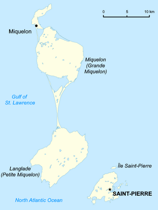
Saint Pierre and Miquelon is an archipelago of eight islands, Saint-Pierre (25 km2) and Miquelon-Langlade (216 km2) being the major ones. Collectively the area of the islands is 242 km2, which is about the size of Brooklyn in New York City. The total coastline is 120 km. The territory also includes the surrounding fishing areas in the North Atlantic Ocean.
Saint-Pierre
The island of Saint-Pierre is surrounded to the south-east by smaller dependencies, Petit Colombier, Île aux Marins, Île aux Pigeons and Île aux Vainqueurs, and Grand Colombier to the north. These islands have all been inhabited at one time or another. [2] The settlement of Saint Pierre on Saint Pierre Island is the largest settlement in Saint Pierre and Miquelon.
St. Pierre is separated from Miquelon-Langlade by a 6 kilometres (3.2 nmi) strait with very fierce currents. Fishermen call this section of ocean "The Mouth of Hell". The waters around these islands are very treacherous, and there have been over 600 shipwrecks along the coasts of the islands. The terrain is also described as mostly barren rock.
Miquelon-Langlade
The island(s) of Miquelon-Langlade consists of three formerly separate islands Miquelon (110 km2), Langlade (91 km2) and Le Cap. In the 18th century, an isthmus of sand called La Dune was formed naturally between Miquelon and Langlade. The isthmus was reinforced by hand with sand and Quaternary deposits to what is now a 13-kilometre (8.1 mi) sand dune. Along the isthmus, there are over 500 wrecked ships. [2]
What was originally the island Miquelon is now also called Grande Miquelon while Petite Miquelon refers to Langlade. [1] The settlement of Miquelon lies at the junction of the northwest corner of Miquelon Island and Le Cap.
Environment
Seals and other wildlife can be found in the Grand Barachois lagoon of Miquelon. Every spring, whales migrating to Greenland are visible off the coasts of Miquelon and St Pierre.
Trilobite fossils have been found on Langlade. There were a number of stone pillars off the island coasts called "L'anse aux Soldats" that have been eroded away and disappeared in the 1970s. [8]
Saint-Pierre and Miquelon (off the coast of Newfoundland)
Maritime claims:
exclusive economic zone:200 nautical miles (370.4 km; 230.2 mi)
territorial sea:12 nautical miles (22.2 km; 13.8 mi)
Elevation extremes:
lowest point: Atlantic Ocean 0 m
highest point: Morne de la Grande Montagne 240 m
Natural resources: fish, deepwater ports
Land use:
arable land: 13%
permanent crops: 0%
permanent pastures: 0%
forests and woodland: 4%
other: 83% (1993 est.)
Natural hazards: persistent fog throughout the year can be a maritime hazard
Environment - current issues: The fishing beds have been overfished, and may or may not recover.
Geography - note: vegetation scanty

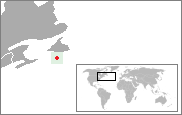
Saint Pierre and Miquelon, officially the Territorial Collectivity of Saint-Pierre and Miquelon, is a self-governing territorial overseas collectivity of France in the northwestern Atlantic Ocean, located near the Canadian province of Newfoundland and Labrador. An archipelago of eight islands, St. Pierre and Miquelon is a vestige of the once-vast territory of New France. Its residents are French citizens; the collectivity elects its own deputy to the National Assembly and participates in senatorial and presidential elections. It covers 242 km2 (93 sq mi) of land and had a population of 6,008 as of the March 2016 census.

Seychelles is a small island country east of the African continent located in the Sea of Zanj due north of Madagascar, with Antsiranana as its nearest foreign city. Seychelles lies between approximately 4ºS and 10ºS and 46ºE and 54ºE. The nation is an archipelago of 155 tropical islands, some granite and some coral. the majority of which are small and uninhabited. The landmass is only 452 km2 (175 sq mi), but the islands are spread wide over an exclusive economic zone of 1,336,559 km2 (516,048 sq mi). About 90 percent of the population of 100,000 live on Mahé, 9 percent on Praslin and La Digue. Around a third of the land area is the island of Mahé and a further third the atoll of Aldabra.

The geography of France consists of a terrain that is mostly flat plains or gently rolling hills in the north and west and mountainous in the south and the east. Metropolitan France has a total size of 551,695 km2 (213,011 sq mi). It is the third largest country in Europe by area and the largest in Western Europe.

The Gulf of St. Lawrence fringes the shores of the provinces of Quebec, New Brunswick, Nova Scotia, Prince Edward Island, Newfoundland and Labrador, in Canada, plus the islands Saint-Pierre and Miquelon, possessions of France, in North America.

Miquelon-Langlade is the larger but less populated of the two communes (municipalities) making up the French overseas collectivity of Saint Pierre and Miquelon, located to the south of Newfoundland in the Gulf of St. Lawrence. It consists of three geological islands: Miquelon, Langlade and Le Cap, connected with tombolos. The communal seat is the settlement of Miquelon, on the northern tip, where the entire island's permanent population of 580 is located. Miquelon Airport provides flights to Montreal and to nearby Saint-Pierre Airport.
The 1929 Grand Banks earthquake occurred on November 18, 1929. The shock had a moment magnitude of 7.2 and a maximum Rossi–Forel intensity of VI and was centered in the Atlantic Ocean off the south coast of Newfoundland in the Laurentian Slope Seismic Zone.
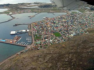
Saint-Pierre is the capital of the French overseas collectivity of Saint Pierre and Miquelon, off the coast of the Canadian island of Newfoundland. Saint-Pierre is the more populous of the two communes (municipalities) making up Saint Pierre and Miquelon.

Penmarch is a commune in the Finistère department of Brittany, northwestern France. It lies 18 km south-west of Quimper by road.

The flag of Saint Pierre and Miquelon is officially the flag of France, as Saint Pierre and Miquelon is a self-governing overseas collectivity of France.
Green Island is a rocky island near the mouth of Fortune Bay, Newfoundland. It is located about 10 km (6 mi) west of the Burin Peninsula of Newfoundland near Point May, and 10 km (6 mi) east of Saint Pierre Island in the French overseas collectivity of Saint Pierre and Miquelon.

The following outline is provided as an overview of and topical guide to Saint Pierre and Miquelon:

Saint Pierre Island, also spelt as Saint-Pierre Island, is one of the three main islands of Saint Pierre and Miquelon. It contains the town of Saint-Pierre, which lies on the island's east coast and is the main population centre of the island group. It is part of an overseas collectivity of France, and is located near the Canadian province of Newfoundland and Labrador.

Miquelon also known as Grande Miquelon, is one of the islands of the archipelago of Saint Pierre and Miquelon, an Overseas collectivity of France located in the Gulf of St. Lawrence in the Atlantic Ocean, 22 km (14 mi) south of the coast of Newfoundland. Miquelon is situated between Le Cap Island to the north and Langlade Island to the south.
The following is an alphabetical list of topics related to the French territorial collectivity of Saint Pierre and Miquelon.
Law enforcement in Saint Pierre and Miquelon is the responsibility of a branch of the French Gendarmerie Nationale. There are two gendarmerie stations in the archipegalo.

While Saint Pierre and Miquelon no longer has any functioning railways, today it has 114 km (71 mi) of highways plus 45 km (28 mi) of unpaved roads. Its only major harbour is at Saint-Pierre although there is a smaller harbour at Miquelon. The dependency has no merchant marine but has two airports; the runway at Saint-Pierre Airport is 1,800 metres (5,910 ft) long, and at Miquelon Airport, 1,000 metres (3,280 ft).
The Miquelon Island Important Bird Area is an area of open sea immediately off the coast of Miquelon Island in the small French archipelago of Saint Pierre and Miquelon off the southern coast of Newfoundland in the North Atlantic Ocean. The 4000 ha site lies off the north and east sides of the island from the waters around Cape Miquelon to the eastern side of La Dune isthmus. It has been identified as an Important Bird Area (IBA) by BirdLife International because it supports a wintering population of red-necked grebes.
Île aux Vainqueurs is a small uninhabited island located about 2 kilometres (1.2 mi) off the coast of Saint-Pierre and Miquelon, a self-governing territorial overseas collectivity of France and the last remaining part of New France in North America.
Île aux Pigeons is a small uninhabited island located about 2 kilometres (1.2 mi) off the coast of Saint-Pierre and Miquelon, a self-governing territorial overseas collectivity of France and the last remaining part of New France in North America.


