The National Oceanic and Atmospheric Administration is an American scientific and regulatory agency within the United States Department of Commerce that forecasts weather, monitors oceanic and atmospheric conditions, charts the seas, conducts deep sea exploration, and manages fishing and protection of marine mammals and endangered species in the U.S. exclusive economic zone.

A tornado warning is a severe weather warning product issued by regional offices of weather forecasting agencies throughout the world to alert the public when a tornado has been reported or indicated by weather radar within the parent severe thunderstorm. It can be issued after a tornado, funnel cloud and rotation in the clouds has been spotted by the public, storm chasers, emergency management or law enforcement, and indicates that residents in the affected areas should take immediate safety precautions.

A tornado watch is a severe weather watch product issued by national weather forecasting agencies when meteorological conditions are favorable for the development of severe thunderstorms capable of producing tornadoes. In addition to the potential for tornado development, thunderstorms that develop within the watch area may contain large hail, straight-line winds, intense rainfall and/or flooding that pose a similar damage risk as the attendant tornado threat. A watch must not be confused with a tornado warning.

A severe thunderstorm warning is a severe weather warning product issued by regional offices of weather forecasting agencies throughout the world to alert the public that severe thunderstorms are imminent or occurring. A severe thunderstorm warning is issued when Doppler weather radar, trained storm spotters or local emergency management personnel indicate that a thunderstorm is producing large hail and high winds capable of causing significant damage, and is expected to continue producing severe weather along the storm's projected track. Flooding is also sometimes caused by torrential rainfall produced by a thunderstorm.

The National Weather Service (NWS) is an agency of the United States federal government that is tasked with providing weather forecasts, warnings of hazardous weather, and other weather-related products to organizations and the public for the purposes of protection, safety, and general information. It is a part of the National Oceanic and Atmospheric Administration (NOAA) branch of the Department of Commerce, and is headquartered in Silver Spring, Maryland, within the Washington metropolitan area. The agency was known as the United States Weather Bureau from 1890 until it adopted its current name in 1970.

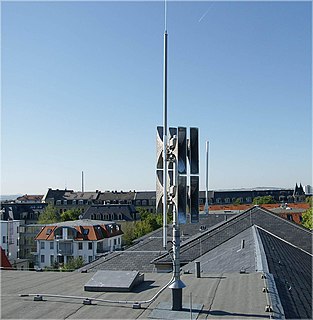
NOAA Weather Radio is an automated 24-hour network of VHF FM weather radio stations in the United States (U.S.) that broadcast weather information directly from a nearby National Weather Service office. The routine programming cycle includes local or regional weather forecasts, synopsis, climate summaries or zone/lake/coastal waters forecasts. During severe conditions the cycle is shortened into: hazardous weather outlooks, short-term forecasts, special weather statements or tropical weather summaries. It occasionally broadcasts other non-weather related events such as national security statements, natural disaster information, environmental and public safety statements, civil emergencies, fires, evacuation orders, and other hazards sourced from the Federal Communications Commission's (FCC) Emergency Alert System. NOAA Weather Radio uses automated broadcast technology that allows for the recycling of segments featured in one broadcast cycle seamlessly into another and more regular updating of segments to each of the transmitters. It also speeds up the warning transmitting process.
Tropical cyclone warnings and watches are alerts issued by national weather forecasting bodies to coastal areas threatened by the imminent approach of a tropical cyclone of tropical storm or hurricane intensity. They are notices to the local population and civil authorities to make appropriate preparation for the cyclone, including evacuation of vulnerable areas where necessary. It is important that interests throughout the area of an alert make preparations to protect life and property, and do not disregard it on the strength of the detailed forecast track. Tropical cyclones are not points, and forecasting their track remains an uncertain science.
An emergency population warning is a method whereby local, regional, or national authorities can contact members of the public en masse to warn them of an impending emergency. These warnings may be necessary for a number of reasons, including:

The Philippine Atmospheric, Geophysical and Astronomical Services Administration is the National Meteorological and Hydrological Services (NMHS) agency of the Philippines mandated to provide protection against natural calamities and to insure the safety, well-being and economic security of all the people, and for the promotion of national progress by undertaking scientific and technological services in meteorology, hydrology, climatology, astronomy and other geophysical sciences. Created on December 8, 1972, by reorganizing the Weather Bureau, PAGASA now serves as one of the Scientific and Technological Services Institutes of the Department of Science and Technology.
Hydrometeorology is a branch of meteorology and hydrology that studies the transfer of water and energy between the land surface and the lower atmosphere. Hydrologists often use meteorologists and data provided by meteorologists. As an example, a meteorologist might forecast 2–3 inches (51–76 mm) of rain in a specific area, and a hydrologist might then forecast what the specific impact of that rain would be on the local terrain.
A Regional Specialized Meteorological Centre (RSMC) is responsible for the distribution of information, advisories, and warnings regarding the specific program they have a part of, agreed by consensus at the World Meteorological Organization as part of the World Weather Watch.
A flood warning is closely linked to the task of flood forecasting. The distinction between the two is that the outcome of flood forecasting is a set of forecast time-profiles of channel flows or river levels at various locations, while "flood warning" is the task of making use of these forecasts to make decisions about whether warnings of floods should be issued to the general public or whether previous warnings should be rescinded or retracted.
A weather warning generally refers to an alert issued by a meteorological agency to warn citizens of approaching dangerous weather. A weather watch, on the other hand, typically refers to an alert issued to indicate that conditions are favorable for the development of dangerous weather patterns, although the dangerous weather conditions themselves are not currently present.

The 2019–20 South Pacific cyclone season was a slightly above-average season in which tropical cyclones formed within the South Pacific Ocean to the east of 160°E. The season officially ran from November 1, 2019 to April 30, 2020, however a tropical cyclone could form at any time between July 1, 2019 and June 30, 2020 and would count towards the season total. The season began on November 22 with the formation of Tropical Cyclone Rita, which would later become a severe tropical cyclone. The season has been near-average in terms of activity, with 8 tropical cyclones and 4 severe tropical cyclones forming during the season. The season featured Cyclone Harold, the first Category 5 severe tropical cyclone in the basin since Cyclone Gita, and one of the strongest since Cyclone Winston. During the season, tropical cyclones are officially monitored by the Fiji Meteorological Service (FMS), Australian Bureau of Meteorology (BOM) and New Zealand's MetService. The United States Armed Forces through the Joint Typhoon Warning Center (JTWC) also monitors the basin and issue unofficial warnings for American interests. The FMS attaches a number and an F suffix to tropical disturbances that form in or move into the basin while the JTWC designates significant tropical cyclones with a number and a P suffix. The FMS, BoM and MetService all use the Australian Tropical Cyclone Intensity Scale and estimate wind speeds over a period of ten minutes, while the JTWC estimated sustained winds over a 1-minute period, which are subsequently compared to the Saffir–Simpson hurricane wind scale (SSHWS)

The Malaysian Meteorological Department is an agency under the Ministry of Environment and Water (MEWA) which is responsible for providing various meteorological, climate and geophysical services to meet the needs of the nation in meteorological, climate and geophysical services for well-being, safety and sustainable development. MetMalaysia is responsible for monitoring the onshore, sea and air weather conditions continuously throughout the country. In addition, MetMalaysia issues forecasts, advice, weather and ocean alerts and climate surveys to reduce disaster risk. MetMalaysia also provides aviation meteorological services to launch aircraft operations and geophysical services to detect earthquakes and tsunami warnings for Malaysia.
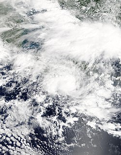
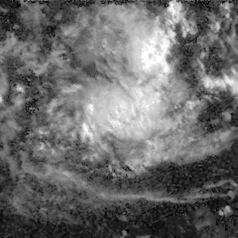
Tropical Cyclone Cempaka was a tropical cyclone that impacted the island of Java and Bali, Indonesia in November 2017. Although it did not make landfall and only developed to a Category 1 tropical cyclone, Cempaka managed to cause 41 deaths, with more than 20,000 people evacuated and causing around US$83.6 million in damages. Cempaka was the fourth cyclone to be registered in Indonesia by the Tropical Cyclone Warning Center of the Indonesian Meteorology, Climatology, and Geophysical Agency (BMKG) since 2008 and the first since Cyclone Bakung in 2014. It also came closer to making landfall in that country than any other cyclone on record.
The Indonesia is an island country in Southeast Asia and Oceania, located in the Pacific and Indian Ocean. The largest island nation in the world, the country is the home of over seventeen thousand islands.
