The East Riding of Yorkshire, or simply East Riding or East Yorkshire, is a ceremonial county and unitary authority area in the Yorkshire and the Humber region of England. It borders North Yorkshire to the north and west, South Yorkshire to the south-west, and Lincolnshire to the south.

The Yorkshire Wolds are low hills in the counties of the East Riding of Yorkshire and North Yorkshire in north-eastern England. The name also applies to the district in which the hills lie.

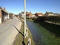
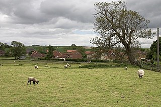
Wold Newton is a small Yorkshire Wolds village and civil parish in the East Riding of Yorkshire, England. It is situated approximately 9 miles (14 km) south of Scarborough and 9 miles (14 km) north-west of Bridlington. Wold Newton is located within the Great Wold Valley and the course of the Gypsey Race, a winterbourne chalk stream, passes through the south of the village. The village of Fordon is also part of the civil parish of Wold Newton. According to the 2011 UK census, Wold Newton parish had a population of 337, an increase on the 2001 UK census figure of 291.

Burton Agnes is a village and civil parish in the East Riding of Yorkshire, England. It is situated on the A614 road midway between Driffield and Bridlington.

Rudston is a small village and civil parish in the East Riding of Yorkshire, England. It is situated between Driffield and Bridlington approximately 6 miles west of Bridlington, and lies on the B1253 road. The Gypsey Race runs through the village, which lies in the Great Wold Valley. There are a number of Neolithic sites associated with the stream and its valley. It is the current Seat of the Clan Macdonald of Sleat, the head of the family residing at Thorpe Hall.

Kilham is a village and civil parish in the East Riding of Yorkshire, England. It is situated about 5 miles (8 km) north-east of Driffield town centre. According to the 2011 UK census, Kilham parish had a population of 1,088, an increase on the 2001 UK census figure of 1,010.

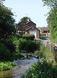
Chalk streams are rivers that rise from springs in landscapes with chalk bedrock. Since chalk is permeable, water percolates easily through the ground to the water table and chalk streams therefore receive little surface runoff. As a result, the water in the streams contains little organic matter and sediment and is generally very clear. The beds of the rivers are generally composed of clean, compacted gravel and flints, which are good spawning areas for Salmonidae fish species.

Burton Fleming is a village and civil parish in the East Riding of Yorkshire, England. It lies close to the border with North Yorkshire. The village is situated approximately 7 miles (11 km) north-west of Bridlington and 6 miles (10 km) south of Filey.

West Beck is the common name given to the upper section of the old River Hull, as it rises in the foothills of the Yorkshire Wolds. After reaching Frodingham Beck at Emmotland, it becomes called the River Hull. It is noteworthy for being the most northerly chalk stream in England. It provides fly fishing for wild brown trout and grayling.

The Malton and Driffield Junction Railway, later known as the Malton and Driffield branch was a railway line in Yorkshire that ran between the towns of Malton, North Yorkshire and Driffield in the East Riding of Yorkshire.

Dickering was a wapentake of the historic county called East Riding of Yorkshire in England, consisting of the north-east part of that county, including the towns of Bridlington and Filey; its territory is now partly in the modern East Riding and partly in North Yorkshire. It was established in 12th or 13th century by combining the three ancient Domesday hundreds of Burton, Huntou (Hunthow) and Torbar. The Wapentake of Dickering ceased to have much significance in the 19th century when the wapentakes were superseded by other administrative divisions for most local government purposes.
Duggleby is a hamlet in the Ryedale district of North Yorkshire, England. It was historically part of the East Riding of Yorkshire until 1974. It is 20 miles (32.2 km) north-east of York and 16 miles (25.7 km) south-west of Scarborough.

Weaverthorpe is a village and civil parish in the Ryedale district of North Yorkshire, England. It is 13 miles (21 km) south-west of Scarborough.

East Lutton is a hamlet in the Ryedale district of North Yorkshire, England. It is situated approximately 9 miles (14 km) east from Malton, and within the Yorkshire Wolds. It is historically part of the East Riding of Yorkshire. The village of West Lutton is 0.5 miles (0.8 km) to the west. The village lies in the Great Wold Valley and the course of the winterbourne stream the Gypsey Race passes through it.
West Lutton is a village in the Ryedale district of North Yorkshire, England. It is situated approximately 9 miles (14 km) east from Malton, and within the Yorkshire Wolds. It was historically part of the East Riding of Yorkshire until 1974. The hamlet of East Lutton is 0.5 miles (0.8 km) to the east. The village lies in the Great Wold Valley and the course of the winterbourne stream the Gypsey Race passes through it.
The Great Wold Valley is the largest and broadest of the valleys cutting into the Yorkshire Wolds in northern England. It carries the Gypsey Race, an intermittent stream, which runs from its source near Wharram-le-Street eastwards along and through the northern Yorkshire Wolds to reach the sea at Bridlington.
The East Riding of Yorkshire is a local government district with unitary authority status, and is a ceremonial county of England. It is named after the historic East Riding of Yorkshire which was one of three ridings alongside the North Riding and West Riding, which were constituent parts a Yorkshire ceremonial and administrative county until 1974. From 1974 to 1996 the area of the modern East Riding of Yorkshire constituted the northern part of Humberside.

Wold Newton Cricket Club represent and play in the village of Wold Newton in the East Riding of Yorkshire, England. Their ground is located off Laking Lane, heading out of the village towards Burton Fleming. Currently the first team plays in Division 2 of the Scarborough Beckett Cricket League,
A gypsey is a name given to intermittent springs and streams in the Yorkshire Wolds, England. Gypseys are streams formed from springs from the waterladen chalk that constitutes the Yorkshire Wolds. The springs flow in late winter or early spring, with the water emanating through unbroken turf.