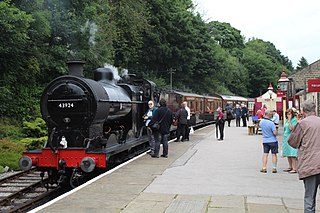
The Keighley & Worth Valley Railway (KWVR) is a 5-mile-long (8 km) heritage railway in the Worth Valley, West Yorkshire, England, which runs from Keighley to Oxenhope. It connects to the National Rail network at Keighley railway station.

Haworth is a village in West Yorkshire, England. Located in the Pennines, Haworth is 3 miles (5 km) south-west of Keighley, 8 miles north of Halifax, 10 miles (16 km) west of Bradford and 10 miles (16 km) east of Colne in Lancashire. The surrounding areas include Oakworth and Oxenhope. Nearby villages include Cross Roads, Stanbury and Lumbfoot.

Keighley is a market town and a civil parish in the City of Bradford Borough of West Yorkshire, England. It is the second largest settlement in the borough, after Bradford.

Stanbury is a village and former civil parish, now in the parish of Haworth and Stanbury, in the metropolitan borough of the City of Bradford in West Yorkshire, England. In 1931 the parish had a population of 453. The name Stanbury translates as Stone Fort from Old English.

The River Don is a river in South Yorkshire and the East Riding of Yorkshire, England. It rises in the Pennines, west of Dunford Bridge, and flows for 69 miles (111 km) eastwards, through the Don Valley, via Penistone, Sheffield, Rotherham, Mexborough, Conisbrough, Doncaster and Stainforth. It originally joined the Trent, but was re-engineered by Cornelius Vermuyden as the Dutch River in the 1620s, and now joins the River Ouse at Goole. Don Valley is a UK parliamentary constituency near the Doncaster stretch of the river.

Airedale is a valley, or dale, in North Yorkshire and West Yorkshire, England. It is named after the River Aire, which flows through it. The upper valley, from Malham Cove to Airton, is known as Malhamdale, named after the village of Malham. At Airton the valley widens and becomes Airedale proper. The river flows past Skipton on to Keighley, Bingley, Shipley, and Leeds.

Oakworth Hall is located in Oakworth, West Yorkshire, England. The manor house was rebuilt in the 17th century, but has a history dating back to 1066. The building overlooks the Worth Valley, facing south towards Haworth.

Worth Valley is a ward in the City of Bradford Metropolitan District Council, West Yorkshire. The population of the ward taken at the 2011 Census was 14,387. It is named after the River Worth that runs through the valley to the town of Keighley where it joins the River Aire. In the north it is bounded by North Yorkshire, in the west by Lancashire and in the south by Calderdale District.

Ingrow is a suburb of Keighley, West Yorkshire, England that lies on the River Worth. The name Ingrow comes from Old Scandinavian which means 'corner of land in the meadow.' The suburb is located on the A629 road and is 0.93 miles (1.5 km) south west of Keighley town centre.

Peasey Beck is a 19.6-kilometre-long (12.2 mi) beck flowing through Cumbria, England. It rises on Lambrigg Fell where it is known as the Sparishaw Beck, flows through Killington Reservoir and converges with Stainton Beck to form the River Bela at Milnthorpe. Prior to 1913, it was known as the River Beela throughout its length.

The Lea Valley Walk is a 50-mile (80 km) long-distance path located between Leagrave, the source of the River Lea near Luton, and the Thames, at Limehouse Basin, Limehouse, east London. From its source much of the walk is rural. At Hertford the path follows the towpath of the River Lee Navigation, and it becomes increasingly urbanised as it approaches London. The walk was opened in 1993 and is waymarked throughout using a swan logo.

Damems is a village near Keighley, within the City of Bradford Metropolitan District, West Yorkshire, England. It is in the BD22 postcode area and uses the 01535 dialling code. Until the mid-19th century it was also known as Dam Elms or Dam Ems.

Harden Beck is a stream that flows from Hewenden Reservoir, over Goit Stock Waterfall to the River Aire in Bingley, West Yorkshire. The route starts out further up the valley as Denholme Beck, Hewenden Beck and Hallas Beck. Its waters are fed by Thornton Moor Reservoir, Stubden Reservoir, Doe Park Reservoir and Hewenden Reservoir.
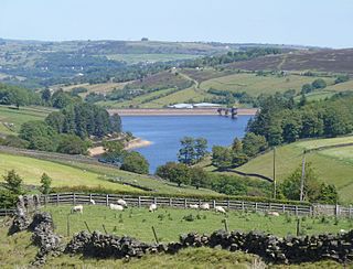
Lower Laithe Reservoir is a man-made upland reservoir that lies 1.2 miles (2 km) west of Haworth, West Yorkshire, England. The reservoir was initially approved under the Keighley Waterworks and Improvement Act of 1869 but work did not begin on its construction until 1911 and even then was delayed because of the First World War. The reservoir was officially opened in August 1925 in front of a crowd of over 8,000 people. Its final tally on cost was £500,000. The reservoir lies in the Sladen Valley and was often referred to as Sladen Valley Reservoir.

The Sea Cut (Scalby Beck) is a small river that enters the North Sea at Scalby Mills, Scarborough, North Yorkshire, England. The beck is fed from local streams in Scalby, Newby and Burniston and other watercourses draining off the nearby hills. It is also a bypass channel for the upper reaches of the River Derwent when it is under flood conditions.

Pickering Beck is a river that runs for over 18 miles (29 km) from its source in the North York Moors National Park through the town of Pickering and on to its confluence with Costa Beck at Kirby Misperton. It is a meandering river that is fed by numerous named and unnamed becks and streams which flow over sandstone and limestone beds and an alluvia of sand, clay silt and gravel. The beck is known for flooding and in recent times has been a beneficiary of funding and experimental flood protection schemes.

Hainworth is a hamlet 1 mile (2 km) south of Keighley in West Yorkshire, England. The hamlet faces north across the lower end of the Worth Valley with a steep wooded incline towards Keighley.

Ponden Reservoir is an artificial upland lake in the Worth Valley, near Stanbury, West Yorkshire, England. Ponden was built as a compensation reservoir after the nearby Watersheddles Reservoir (upstream) was used to divert water away from the River Worth. Ponden was needed to regulate the flow of water down the river into the downstream mills in the valley.

The Worth Valley is a geographic area in West Yorkshire, England, that extends eastwards from Crow Hill and Oxenhope Moor, providing drainage for the River Worth for nearly 10 miles (16 km) to the River Aire. It is a side valley to Airedale, with the River Worth being a major tributary of the River Aire. The Worth Valley was important for its contribution to the textiles industry of the West Riding of Yorkshire and was furnished with several reservoirs to allow mills to operate within the valley. Most of the reservoirs are still in use into the modern day.

Watersheddles Reservoir is an upland artificial lake in Lancashire, England. The reservoir was opened in 1877 by the Keighley Corporation Water Works, and is now owned by Yorkshire Water. It supplies water to the Worth Valley and Keighley area and compounds several streams at the source of the River Worth.
 Small brown trout from the River Worth
 Footbridge over the River Worth near Lumbfoot
 Bronte Way footbridge over the infant River Worth
 Keighley - footpath alongside River Worth
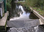 River Worth - Coney Lane, Keighley
 River Worth and Weir


