Protected areas of Tasmania consist of protected areas located within Tasmania and its immediate onshore waters, including Macquarie Island. It includes areas of crown land managed by Tasmanian Government agencies as well as private reserves. As of 2016, 52% of Tasmania's land area has some form of reservation classification, the majority is managed by the Tasmania Parks & Wildlife Service. Marine protected areas cover about 7.9% of state waters.
Landforms are categorized by characteristic physical attributes such as their creating process, shape, elevation, slope, orientation, rock exposure, and soil type.

Southwick Beach State Park is a New York State park that lies along an unusual stretch of sandy beach on the eastern shore of Lake Ontario. The park is 464 acres (188 ha) in size with a 3,500 foot (1,100 m) length of beach, and is visited annually by about 100,000 people. Immediately to the south is the Lakeview Wildlife Management Area, which extends the publicly accessible beach by several miles. They are in the Town of Ellisburg in Jefferson County, New York south of the lakeside community of Jefferson Park.

The Kankakee River is a tributary of the Illinois River, approximately 133 miles (214 km) long, in the Central Corn Belt Plains of northwestern Indiana and northeastern Illinois in the United States. At one time, the river drained one of the largest wetlands in North America and furnished a significant portage between the Great Lakes and the Mississippi River. Significantly altered from its original channel, it flows through a primarily rural farming region of reclaimed cropland, south of Lake Michigan.

The Southern Laurentian Channel is an ancient underground river in southern Ontario, Canada. The river predates the recent ice ages. The river valley was filled with glacial debris. Water still flows down this old valley—underground. The source of the aquifer is the Georgian Bay, approximately 200 kilometres (120 mi) away.

The Driftless Area is a region in southwestern Wisconsin, southeastern Minnesota, northeastern Iowa, and the extreme northwestern corner of Illinois, of the American Midwest. The region escaped the flattening effects of glaciation during the last ice age and is consequently characterized by steep, forested ridges, deeply carved river valleys, and karst geology characterized by spring-fed waterfalls and cold-water trout streams. Ecologically, the Driftless Area's flora and fauna are more closely related to those of the Great Lakes region and New England than those of the broader Midwest and central Plains regions. Colloquially, the term includes the incised Paleozoic Plateau of southeastern Minnesota and northeastern Iowa. The region includes elevations ranging from 603 to 1,719 feet at Blue Mound State Park, and covers 24,000 square miles (62,200 km2). The rugged terrain is due both to the lack of glacial deposits, or drift, and to the incision of the upper Mississippi River and its tributaries into bedrock.

The Scarborough Bluffs, also known as The Bluffs, is an escarpment in the Scarborough district of Toronto, Ontario, Canada. There are nine parks along the bluffs, with Bluffers Park being the only one with a beach. Forming much of the eastern portion of Toronto's waterfront, the Scarborough Bluffs stands above the shoreline of Lake Ontario. At its highest point, the escarpment rises 90 metres (300 ft) above the coastline and spans a length of 15 kilometres (9.3 mi).

Rome Sand Plains is a 15,000-acre (61 km2) pine barrens about five miles (8.0 km) west of the city center of Rome in Oneida County in central New York. It consists of a mosaic of sand dunes rising about 50 feet (15 m) above low peat bogs that lie between the dunes. The barrens are covered with mixed northern hardwood forests, meadows, and wetlands. About 4,000 acres (16 km2) are protected in conservation preserves. Pine barrens are typical of seacoasts; the Rome Sand Plains is one of only a handful of inland pine barrens remaining in the United States. A second inland pine barrens, the Albany Pine Bush, is also found in New York, located north and west of state's capital Albany.

Moraine State Park is a Pennsylvania state park on 16,725 acres (6,768 ha) in Brady, Clay, Franklin, Muddy Creek, and Worth townships in Butler County, Pennsylvania, in the United States.

Interstate Park comprises two adjacent state parks on the Minnesota–Wisconsin border, both named Interstate State Park. They straddle the Dalles of the St. Croix River, a deep basalt gorge with glacial potholes and other rock formations. The Wisconsin park is 1,330 acres (538 ha) and the Minnesota park is 298 acres (121 ha). The towns of Taylors Falls, Minnesota and St. Croix Falls, Wisconsin are adjacent to the park. Interstate Park is within the Saint Croix National Scenic Riverway and the Ice Age National Scientific Reserve. The western terminus of the Ice Age National Scenic Trail is on the Wisconsin side. On the Minnesota side, two areas contain National Park Service rustic style buildings and structures that are listed on the National Register of Historic Places.
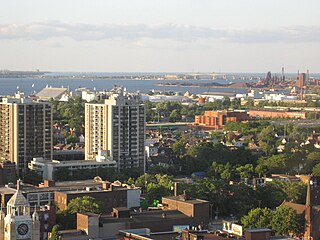
Hamilton is located on the western end of the Niagara Peninsula and wraps around the westernmost part of the Lake Ontario. Most of the city including the downtown section lies along the south shore. Situated in the geographic centre of the Golden Horseshoe, it lies roughly midway between Toronto and Buffalo. The two major physical features are Hamilton Harbour marking the northern limit of the city and the Niagara Escarpment running through the middle of the city across its entire breadth, bisecting the city into 'upper' and 'lower' parts.
The Toronto ravine system is a distinctive feature of the city's geography, consisting of a network of deep ravines which forms a large urban forest that runs through most of Toronto. The ravine system is the largest in any city in the world, with the Ravine and Natural Feature Protection Bylaw protecting approximately 110 square kilometres (42 sq mi) of public and privately-owned land. The ravine system has been presented as a central characteristic of the city, with the size of the ravine system leading Toronto to be described as "a city within a park".

The Iroquois County State Wildlife Area is an Illinois state park that occupies 2,480 acres (1,004 ha) in northeastern Iroquois County, near the border with Indiana. The nearest municipality is Beaverville, Illinois, and the nearest exit on a limited-access highway is Exit 302 on Interstate 57.

The Kankakee Outwash Plain is a flat plain interspersed with sand dunes in the Kankakee River valley in northwestern Indiana and northeastern Illinois of the United States. It is just south of the Valparaiso Moraine and was formed during the Wisconsin Glaciation. As the glacier, stopped at the Valparaiso Moraine, melted, the meltwater was carried away to the outwash plain. On the south side of the moraine, where the elevation drops, the meltwaters eroded away valleys, carrying sand and mud with them. As the muddy meltwater reached the valley where the slope lessened, the water slowed, depositing the sand on the outwash plain. This created a smooth, flat, and sandy plain. Before its draining, the Kankakee Marsh, located on the outwash plain, was one of the largest freshwater marshes in the United States.
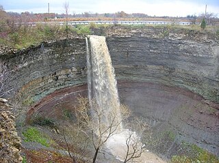
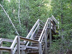
Devil's Punch Bowl is a 37-metre ribbon waterfall on the Niagara Escarpment, in the Stoney Creek community of Hamilton, Ontario, Canada. It is found in the Devil's Punchbowl Conservation Area, maintained by the Hamilton Conservation Authority, and features an escarpment access trail with connections to a recently improved section of the Bruce Trail. Stoney Creek's Dofasco 2000 Trail is nearby. The Punch Bowl is also known as Horseshoe Falls for the distinctive shape of the cliff-face, which somewhat resembles its much larger cousin in Niagara Falls.
The Oro Moraine is a glacial moraine in Simcoe County, Ontario, Canada. The moraine covers 141 square kilometres (54 sq mi) north of Barrie, Ontario. The moraine drains into Georgian Bay on Lake Huron, and the smaller Lake Simcoe.
Pringle Creek is a small watercourse that drains into Lake Ontario in Whitby, Ontario. It drains 2,847 hectares (10.99 sq mi).
Tooley Creek is a small watercourse that drains into Lake Ontario near Darlington, Ontario. It drains 1,050 hectares (4.1 sq mi).
The geology of North Dakota includes thick sequences oil and coal bearing sedimentary rocks formed in shallow seas in the Paleozoic and Mesozoic, as well as terrestrial deposits from the Cenozoic on top of ancient Precambrian crystalline basement rocks. The state has extensive oil and gas, sand and gravel, coal, groundwater and other natural resources.

Lynde Shores Conservation Area is a protected area located in Whitby, Ontario, Canada. Located on the northern shore of Lake Ontario, the conservation area composes the mouth of Lynde Creek and its surrounding marshlands, including Cranberry Marsh. The area is operated by the Central Lake Ontario Conservation Authority.