The Humber River is a river in Southern Ontario, Canada. It is in the Great Lakes Basin, is a tributary of Lake Ontario and is one of two major rivers on either side of the city of Toronto, the other being the Don River to the east. It was designated a Canadian Heritage River on September 24, 1999.

The Oak Ridges Moraine is an ecologically important geological landform in the Mixedwood Plains of south-central Ontario, Canada. The moraine covers a geographic area of 1,900 square kilometres (730 sq mi) between Caledon and Rice Lake, near Peterborough. One of the most significant landforms in southern Ontario, the moraine gets its name from the rolling hills and river valleys extending 160 km (99 mi) east from the Niagara Escarpment to Rice Lake, formed 12,000 years ago by advancing and retreating glaciers during the last glaciation period. Below the approximately 200 metre thick glacial derived sediments of the moraine lies thick bedrock successions of Precambrian rocks and up to 200 metres of Ordovician aged rock, capped by a regional unconformity of erosion and non-deposition to the Quaternary period. Rivers and lakes scatter the landscape and are important for creating habitat for the rich diversity of species of animals, trees and shrubbery. These are also the supply of fresh water to aquifers in the moraine through complex subterranean connections. Construction development nearby, and with expansion of communities around the moraine in need of potable water, it is a contested site in Ontario, since it stands in the path of major urban development. Conservation of the moraine is thus an important step for keeping aquifers in a safe drinkable condition while also protecting the natural ecosystems surrounding and within the moraine. This region has been subject to multiple decades of scientific research to study the origins of formation, and how early communities used the land. A larger focus currently is how to source potable water without removing the aquifer entirely.

The Rouge River is a river in Markham, Pickering, Richmond Hill and Toronto in the Greater Toronto Area of Ontario, Canada. The river flows from the Oak Ridges Moraine to Lake Ontario at the eastern border of Toronto, and is the location of Rouge Park, the only national park in Canada within a municipality. At its southern end, the Rouge River is the boundary between Toronto and southwestern Pickering in the Regional Municipality of Durham.
Palgrave is a Compact Rural Community and unincorporated place in the Town of Caledon, Regional Municipality of Peel in the Greater Toronto Area of Ontario, Canada. It is about 10 kilometres (6.2 mi) north of Bolton and about 50 kilometres (31 mi) northwest of Toronto. Palgrave is located east of Orangeville, south of Alliston, west of Newmarket and north of Brampton.
Ansnorveldt is a hamlet located at the northeastern extent of King Township, in Ontario, Canada. It is located in the Holland Marsh, north of Highway 9. Whereas most of King township is in the Oak Ridges—Markham electoral district, Ansnorveldt and all other portions of King north of Highway 9 are part of the York—Simcoe electoral district, represented federally by Scot Davidson of the Conservative Party of Canada and provincially by Caroline Mulroney of the Progressive Conservative Party of Ontario.
Pottageville is an unincorporated community located in northeastern King Township, in Ontario, Canada. It is near Schomberg. It is named for one of its early settlers, Edward Pottage.

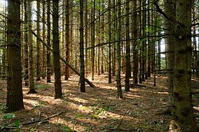
The Oak Ridges Moraine lies in Southern Ontario, Canada. It contains the headwaters of sixty-five rivers and streams. It has a wide diversity of woodlands, wetlands, watercourses, kettle lakes, kettle bogs, and significant flora and fauna. It is one of the few remaining continuous green corridors in southern Ontario: it remains thirty percent forested and is one of the last refuges for forest birds in all of southern Ontario.
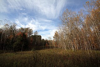
The politics of the Oak Ridges Moraine in southern Ontario, Canada, have centred on the question of how to preserve this extensive natural resource that is increasingly threatened by human modification. Although preservation of the moraine was first suggested in the 1940s, and intermittently over the subsequent fifty years, it was not until 1991 that the issue achieved prominence in political discourse. For the ensuing decade, use of the moraine was hotly contested between the interests of local residents, developers and environmentalists.

The Lake Simcoe Region Conservation Authority is a conservation authority established in 1951, and is among the oldest in the Canadian province of Ontario.
Hay Swamp is a provincially significant wetland complex, 1839 hectares in size, located in parts of the central land areas of the municipalities of Bluewater and South Huron, in southwestern Ontario, Canada. Approximately 13 kilometers (8.1 mi) in length and 2 kilometers (1.2 mi) in width, at its widest point; it consists of 15 extensively forested individual wetlands, situated on either side, of sections of both the upper drainage of the Ausable River and its tributary, Black Creek.
There are numerous natural areas in King, a township in Ontario, Canada. These areas are zones officially designated by the Government of Ontario that are within the township and exhibit provincially or regionally significant features representative of the region. The list of zones is defined and maintained by the provincial Ministry of Natural Resources Natural Heritage Information Centre.
Happy Valley Forest is a 6.48 square kilometre provincially significant ecological area, classified as an Area of Natural and Scientific Interest by the Ontario Ministry of Natural Resources. It consists of an upland forest on steeply rolling topography, various wooded swamps, and minor wetland areas. A few small kettle ponds are also present.
The Glenville Hills Kames is a 345 hectare provincially significant Earth Science Area of Natural and Scientific Interest in Ontario, Canada.
The Uxbridge Forest Kames is a 644-hectare (1,591-acre) provincially significant Earth Science Area of Natural and Scientific Interest in Ontario, Canada. The land is owned and managed by the Toronto and Region Conservation Authority.
Petticoat Creek is a stream in the cities of Pickering, Toronto and Markham in the Greater Toronto Area of Ontario, Canada. The creek is in the Great Lakes Basin, is a tributary of Lake Ontario, and falls under the auspices of the Toronto and Region Conservation Authority. Its watershed covers 26.77 square kilometres (10.34 sq mi), and the cumulative length of all its branches is 49 kilometres (30 mi). Land use in the watershed consists of 52% agricultural, 27% protected greenspace and 21% urban.
The Oro Moraine is a glacial moraine in Simcoe County, Ontario, Canada. The moraine covers 141 square kilometres (54 sq mi) north of Barrie, Ontario. The moraine drains into Georgian Bay on Lake Huron, and the smaller Lake Simcoe.

The Black River is a river in the Regional Municipality of York and the Regional Municipality of Durham in Central Ontario, Canada. It is part of the Great Lakes Basin, and is a tributary of Lake Simcoe; the entire watershed is under the auspices of the Lake Simcoe Region Conservation Authority.

Bowmanville Creek is a stream in the municipality of Clarington, Regional Municipality of Durham in south-central Ontario, Canada. It flows from the Oak Ridges Moraine to Lake Ontario at Bowmanville. The creek is under the auspices of the Central Lake Ontario Conservation Authority.

The Toronto waterway system comprises a series of natural and man-made watercourses in the Canadian city of Toronto. The city is dominated by a large river system spanning most of the city including the Don River, Etobicoke Creek, Highland Creek, Humber River, Mimico Creek and Rouge River.

Stephen's Gulch is a conservation area located in the municipality of Clarington, Ontario. The conservation area borders a large section of the Soper Creek, and contains 354 acres of deciduous forests as well as coniferous forests and swamps. The conservation area is also an important watershed area for Ontario.