Huguenot station

Last updated

Huguenot
MTA NYC logo.svg Staten Island Railway station (rapid transit)
Huguenot station - September 2020.jpg
Huguenot station in September 2020
General information
LocationHuguenot Avenue & West Terrace
Huguenot, Staten Island
Coordinates 40°32′01″N74°11′31″W / 40.5336°N 74.1919°W / 40.5336; -74.1919
Platforms2 side platforms
Tracks2
ConnectionsAiga bus trans.svg NYCT Bus: S55, SIM2, SIM24
Construction
Structure type Open-cut
Other information
Station code516
History
OpenedJune 2, 1860 [1]
Previous namesBloomingview
Huguenot Park
Services
Preceding station MTA NYC logo.svg Staten Island Railway Following station
Annadale
toward St. George
NYCS-bull-trans-SIR-Std.svg Prince's Bay
toward Tottenville
Location
Huguenot station

The Huguenot station is a Staten Island Railway station in the neighborhood of Huguenot, Staten Island, New York.

Contents

History

The station opened on June 2, 1860, with the opening of the Staten Island Railway from Annadale to Tottenville. [1] The station's original name was Bloomingview, [1] named after the former town of Bloomingview, which is present day Huguenot. [2] Afterwards the station was named "Huguenot Park," which was shortened to simply "Huguenot" by the Metropolitan Transportation Authority (MTA) shortly after it took control of the railway from the Baltimore and Ohio Railroad in 1971 (the MTA also shortened the name of the "Old Town Road" station to simply "Old Town" at that time).

In 2019, the MTA announced that this station would become ADA-accessible as part of the agency's 2020–2024 Capital Program. [3]

A request for proposals was put out on May 18, 2023 for the contract for a project bundle to make 13 stations accessible, including Huguenot. [4] A contract for two ramps at the station was awarded in December 2023. [5]

Station layout

The station is located on an open cut at Huguenot Avenue and has two side platforms. There is a steel and concrete canopy over the platforms at the stairs and an additional canopy is located about halfway down the northbound platform, [6] features used as part of SIR station upgrades and platform extensions in the 1990s. Some morning rush hour local trains originate here; a pair of switches south of the station are used to reverse the direction of these trains. A spur used for ballast trains branches off the southbound track across Huguenot Avenue from the station entrance. [7] [8] This stop provides access to the nearby Tottenville High School.

GroundStreet levelStation house, exit/entrance, buses, parking
Platform
level
Side platform
Southbound NYCS-bull-trans-SIR-Std.svg toward Tottenville (Prince's Bay)
Northbound NYCS-bull-trans-SIR-Std.svg toward St. George (Annadale)
Side platform

Exit

There are exit stairs at the south end, and a brick stationhouse built in 1939 on street level. [9] [10] A pedestrian overpass formerly existed at the north end. The MTA runs a park & ride lot at the station.

Related Research Articles

<span class="mw-page-title-main">Burnside Avenue station</span> New York City Subway station in the Bronx

The Burnside Avenue station is an express station on the IRT Jerome Avenue Line of the New York City Subway. Located at the intersection of Burnside and Jerome Avenues in the Morris Heights and Unniversity Heights neighborhoods of the Bronx, it is served by the 4 train at all times. It also serves as a rush hour short turn northern terminal for select 4 trains from Crown Heights–Utica Avenue.

<span class="mw-page-title-main">New Lots Avenue station (IRT New Lots Line)</span> New York City Subway station in Brooklyn

The New Lots Avenue station is the eastern terminal of the IRT New Lots Line of the New York City Subway. Located in East New York, Brooklyn, it is the terminal for the 3 train at all times except late nights, when the 4 train takes over service. During rush hours, occasional 2, 4, and 5 trains also stop here.

<span class="mw-page-title-main">46th Street–Bliss Street station</span> New York City Subway station in Queens

The 46th Street–Bliss Street station is a local station on the IRT Flushing Line of the New York City Subway. Located at the intersection of 46th Street and Queens Boulevard in Sunnyside, Queens, it is served by the 7 train at all times.

<span class="mw-page-title-main">New York City Subway stations</span> Rapid transit system in New York City

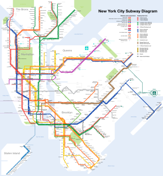
The New York City Subway is a rapid transit system that serves four of the five boroughs of New York City, New York: the Bronx, Brooklyn, Manhattan, and Queens. Its operator is the New York City Transit Authority, which is itself controlled by the Metropolitan Transportation Authority of New York. In 2015, an average of 5.65 million passengers used the system daily, making it the busiest rapid transit system in the United States and the 11th busiest in the world.

<span class="mw-page-title-main">Wakefield–241st Street station</span> New York City Subway station in the Bronx

The Wakefield–241st Street station is a terminal station on the IRT White Plains Road Line of the New York City Subway, located at the intersection of 241st Street and White Plains Road in the Wakefield neighborhood of the Bronx. It is served by the 2 train at all times. This station is geographically the northernmost station in the entire New York City Subway system.

<span class="mw-page-title-main">Bay Ridge–95th Street station</span> New York City Subway station in Brooklyn

The Bay Ridge–95th Street station is the southern terminal station on the BMT Fourth Avenue Line of the New York City Subway. Despite the name, the station is located in the neighborhood of Fort Hamilton at the intersection of 95th Street and Fourth Avenue in southwestern Brooklyn. It is served by the R train at all times. Geographically, this station is the westernmost New York City Subway station.

<span class="mw-page-title-main">Ozone Park–Lefferts Boulevard station</span> New York City Subway station in Queens

The Ozone Park–Lefferts Boulevard station is an elevated terminal station on the IND Fulton Street Line of the New York City Subway, located at the intersection of Lefferts Boulevard and Liberty Avenue in Queens. It serves as the terminus of the A route's Lefferts Boulevard branch. Despite its name, the station is not actually located in Ozone Park, but rather in the adjacent neighborhood of South Richmond Hill.

<span class="mw-page-title-main">Wilson Avenue station</span> New York City Subway station in Brooklyn

The Wilson Avenue station is a station on the BMT Canarsie Line of the New York City Subway. Located at the intersection of Wilson Avenue and Moffat Street in Brooklyn, it is served by the L train at all times.

<span class="mw-page-title-main">Tremont Avenue station</span> New York City Subway station in the Bronx

The Tremont Avenue station is an express station on the IND Concourse Line of the New York City Subway. Located at the intersection of East Tremont Avenue and Grand Concourse, it is served by the D train at all times and B train during rush hours only. It has three tracks and two island platforms.

<span class="mw-page-title-main">Woodhaven Boulevard station (BMT Jamaica Line)</span> New York City Subway station in Queens

The Woodhaven Boulevard station is an elevated station on the BMT Jamaica Line of the New York City Subway, located in Woodhaven, Queens. It is served by the J train at all times and the Z train during rush hours in the peak direction. As of December 2023, the westbound platform is temporarily closed.

<span class="mw-page-title-main">Norwood Avenue station</span> New York City Subway station in Brooklyn

The Norwood Avenue station is a skip-stop station on the BMT Jamaica Line of the New York City Subway. Located at the intersection of Norwood Avenue and Fulton Street in Cypress Hills, Brooklyn, it is served by the Z train during rush hours in peak direction and the J at all other times.

<span class="mw-page-title-main">Atlantic station (Staten Island Railway)</span>

Atlantic was a Staten Island Railway station in the neighborhood of Tottenville, Staten Island, New York. With the condition of the station having deteriorated after the 1990s, this station, and the Nassau station to the north, were replaced by a new station at Arthur Kill Road. When that station opened in January 2017, Atlantic station closed and subsequently demolished.

<span class="mw-page-title-main">Richmond Valley station</span> Staten Island Railway station

The Richmond Valley station is a Staten Island Railway station in the neighborhood of Richmond Valley, Staten Island, New York. Located at Richmond Valley Road and Amboy Road on the main line, the station is a mixture of open cut at the north end and grade level at the south end.

<span class="mw-page-title-main">Prince's Bay station</span> Staten Island Railway station

The Prince's Bay station is a Staten Island Railway station in the neighborhood of Prince's Bay, Staten Island, New York.

<span class="mw-page-title-main">Annadale station</span> Staten Island Railway station

The Annadale station is a Staten Island Railway station in the neighborhood of Annadale, Staten Island, New York.

<span class="mw-page-title-main">New Dorp station</span> Staten Island Railway station

The New Dorp station is a Staten Island Railway station in the neighborhood of New Dorp, Staten Island, New York. The station became fully compliant with the Americans with Disabilities Act of 1990 in 2023.

<span class="mw-page-title-main">Old Town station (Staten Island Railway)</span> Staten Island Railway station

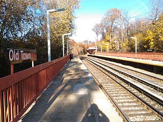
The Old Town station is a Staten Island Railway station in the neighborhood of Old Town, Staten Island, New York.

<span class="mw-page-title-main">Clifton station (Staten Island Railway)</span> Staten Island Railway station

The Clifton station is a Staten Island Railway station in the neighborhood of Clifton, Staten Island, New York. This station was the original terminal of the Staten Island Railway from 1860 until 1886. The station was known as Vanderbilt's Landing, and was used as a transfer point for passengers going to Manhattan via ferries to South Ferry.

<span class="mw-page-title-main">Richmond County Bank Ballpark station</span>

Richmond County Bank Ballpark, styled simply as Ball Park and BallPark on station signage, is a disused station on the Staten Island Railway, located at Wall Street and Richmond Terrace.

<span class="mw-page-title-main">Arthur Kill station</span> Staten Island Railway station

The Arthur Kill station is a station on the Staten Island Railway (SIR). The station opened on January 21, 2017, replacing the Atlantic and Nassau stations, which were the two stations in the poorest condition along the line at the time. It is located on Arthur Kill Road near Lion Street and Barnard Avenue, in the Tottenville neighborhood of Staten Island, New York. It has two tracks and two side platforms, and is ADA-accessible via ramps.

References

  1. 1 2 3 Irvin Leigh and Paul Matus (December 23, 2001). "SIRT The Essential History". p. 5. Retrieved March 3, 2009.
  2. http://www.statenislandhistory.com/old-town-names.html
  3. "Press Release - MTA Headquarters - MTA Announces 20 Additional Subway Stations to Receive Accessibility Improvements Under Proposed 2020-2024 Capital Plan". MTA. December 19, 2019. Retrieved December 25, 2019.
  4. "A37758 Design-Build Services for ADA Upgrades Package 5: Accessibility Upgrades at 13 Stations in the City of New York". mta.info. Metropolitan Transportation Authority. May 18, 2023. Retrieved May 10, 2024.
  5. "December 2023 MTA Board Action Items". Metropolitan Transportation Authority. December 20, 2023. pp. 46–47. Archived from the original on December 22, 2023. Retrieved March 2, 2024.
  6. Darlington, Peggy (June 2000). "Huguenot Canopies". nycsubway.org. Retrieved December 24, 2017.
  7. Rosenfeld, Robbie (October 16, 2013). "Track ballast loading". nycsubway.org. Retrieved December 24, 2017.
  8. "Part of Ward 5 Borough of Richmond Map". secretsi.com. 1873. Archived from the original on March 5, 2016. Retrieved December 24, 2017.
  9. Rosenfeld, Robbie (October 16, 2013). "Stationhouse". nycsubway.org. Retrieved December 24, 2017.
  10. "Map of NYC Subway Entrances". NYC Open Data. City of New York . Retrieved July 10, 2018.

Commons-logo.svg Media related to Huguenot (Staten Island Railway station) at Wikimedia Commons