North Shore Branch

Last updated

North Shore Branch
Bard Av SIRT jeh.JPG
The abandoned North Shore Branch. The Bayonne Bridge can be seen in the background.
Overview
StatusAbandoned
OwnerStaten Island Railway
Locale Staten Island, New York, U.S.
Termini
Stations14
Service
Type Rapid transit
Rail freight transport
System Staten Island Railway
Operator(s)Staten Island Railway
History
OpenedFebruary 23, 1886
ClosedMarch 31, 1953
Technical
Number of tracks2
Track gauge 4 ft 8+12 in (1,435 mm)
Electrification 1925

The North Shore Branch is an abandoned branch of the Staten Island Railway in New York City, which operated along Staten Island's North Shore from Saint George to Port Ivory. The line continues into New Jersey via the Arthur Kill Vertical Lift Bridge to Aldene Junction in Cranford .

Contents

The line started construction in 1884, and rapid transit service on the line started on February 23, 1886. Passenger service on the North Shore Branch ended on March 31, 1953, although freight service continued to run along part of the North Shore Branch until 1989. In 2005, freight service on the western portion of the line was reactivated, and there are proposals to reactivate the former passenger line for rail or bus service.

Operation

Trains on the branch used tracks 10 through 12 at the Saint George Terminal. Trains originally consisted of two and three cars during the AM and PM rush hours, and one car at other times; by the end of passenger service, trains used only one car. [1]

The fares on the branch were collected by the conductor on the train, who had to pull a cord, similar to how it was done with trolleys. The Baltimore & Ohio Railroad, which owned the branch, wanted to reduce service on the branch, and eventually abandon it. They purposely looked the other way when conductors skimmed money from the collected fares, allowing them to show a lower ridership to the Interstate Commerce Commission, and in return improve their chances for abandoning the branch. [2]

Route description

The overpass over Nicholas Avenue (looking east) between the Port Richmond Viaduct and the open-cut section of the line. SIRT Nichholas Av overpass jeh.JPG
The overpass over Nicholas Avenue (looking east) between the Port Richmond Viaduct and the open-cut section of the line.

The North Shore branch of the SIRT began at Saint George Terminal, using the northernmost platform and tracks of the terminal. [3] After running through the St. George Freight Yard (near the modern Ballpark Station), the line ran on the shore of the Kill Van Kull from New Brighton to West Brighton. The line ran on land between St. George and New Brighton, and on a ballast-filled wood trestle supported by a wood retaining wall through Livingston and West Brighton. Though the right-of-way is distinguishable, little evidence of this portion of the line exists today, except for abandoned tracks and supports, much of which has eroded into the kill. [4] [5]

Beyond West Brighton near a NYCDEP water pollution control facility, the line rose onto a reinforced concrete trestle known as the Port Richmond Viaduct, crossing Bodine Creek and running for about a mile through the Port Richmond neighborhood. [6] [7] West of Nicholas Avenue near Port Richmond High School, the line entered an open cut, crossing under the Bayonne Bridge approach and continued west to the Arlington Yard and station at South Avenue. [8] Rapid transit service continued via a northern spur to Port Ivory; freight service passed the current Howland Hook Marine Terminal (adjacent to Port Ivory) and crossed the Arthur Kill Vertical Lift Bridge to Cranford Junction in New Jersey. [9] The right-of-way from the Port Richmond Viaduct to Arlington Yard has remained intact and in good condition, though the former station sites and infrastructure are dilapidated and need rehabilitation or replacement should passenger service be reactivated. [10]

History

A map of the Staten Island Rapid Transit Company from 1885 A Map of the Staten Island Rapid Transit Company from 1885.png
A map of the Staten Island Rapid Transit Company from 1885

Opening

The Baltimore & Ohio Railroad, operators of the SIRT until 1971, began construction on the line in 1884. [11] In order to build the North Shore Branch, property needed to be acquired along the North Shore of Staten Island. About 2 miles (3.2 km) of rock fill along the Kill Van Kull needed to be built to deal with opposition from property owners in Sailor's Snug Harbor. [12] In order to get property for the line to pass over the cove at Palmer's run, the company had to undergo a contest in litigation. [13] [14] In Port Richmond, some property was acquired, displacing businesses and homes. [15] On the northwestern corner of Staten Island, the B&O purchased a farm and renamed it "Arlington"; the B&O built a freight yard on the farm by 1886. [15]

The SIR was leased to the B&O for 99 years in 1885. [16] [17] The proceeds of the sale were used to complete the terminal facilities at St. George, pay for 2 miles (3.2 km) of waterfront property, complete the Rapid Transit Railroad, build a bridge over the Kill Van Kull at Elizabethport, and build other terminal facilities. [18] The North Shore Branch opened for service on February 23, 1886, up to Elm Park cutting travel times to 39 minutes from an hour and a half via the ferry system. [13] The Saint George Terminal opened on March 7, 1886, and all SIR lines were extended to this station. [19] [20] On March 8, 1886, the South Beach Branch opened for passenger service to Arrochar. [21] The remainder of the North Shore Branch to its terminus at Erastina was opened in the summer of 1886. [1] The new lines opened by the B&O railroad were called the Staten Island Rapid Transit Railway, while the original line from Clifton to Tottenville was called the Staten Island Railway. [11] [22] In 1889–1890 a station was put up at the South Avenue grade crossing at Arlington in 1889–1890, where trains were turned on their way back to St. George. [23]

Baltimore & Ohio viaduct under construction over the Arthur Kill connecting Staten Island and New Jersey Baltimore & Ohio Viaduct Under Construction Over the Arthur Kill Connecting Staten Island and New Jersey.png
Baltimore & Ohio viaduct under construction over the Arthur Kill connecting Staten Island and New Jersey

Various proposals were made by the B&O for a railroad between Staten Island and New Jersey. The accepted proposal consisted of a 5.25-mile (8.45 km) line from the Arthur Kill to meet the Jersey Central at Cranford, through Union County and the communities of Roselle Park and Linden. [15] Construction on this road started in 1889, [15] and the line was finished in the latter part of that year. [1] Congress passed a law on June 16, 1886, authorizing the construction of a 500-foot (150 m) swing bridge over the Arthur Kill, after three years of effort by Erastus Wiman. [24] [25] The start of construction was delayed for nine months by the need for approval of the Secretary of War, [1] [25] and another six months due to an injunction from the State of New Jersey. [25] This required construction to continue through the brutal winter of 1888 [24] [25] because Congress had set a completion deadline of June 16, 1888, two years after signing the bill. [25] The bridge was completed three days early on June 13, 1888, at 3 p.m. [26] [25] At the time of its opening, the Arthur Kill Bridge was the largest drawbridge ever constructed in the world. There were no fatalities in the construction of the bridge. [25] On January 1, 1890, [1] the first train operated from Saint George Terminal to Cranford Junction. [27] Once the Arthur Kill Bridge was completed, pressure was brought upon the United States War Department by the Lehigh Valley Railroad and the Pennsylvania Railroad to have the newly built bridge torn down and replaced with a bridge with a different design, claiming that it was an obstruction for the navigation of the large numbers of coal barges past Howland Hook on the Arthur Kill. They were not successful in these efforts, however. [28]

1900s

Viaduct station at Tower Hill SIRT Grove & Sharpe Avs jeh.JPG
Viaduct station at Tower Hill

In 1905, Procter & Gamble opened a large plant near Arlington Yard, later called Port Ivory, resulting in additional traffic. The line's electrification project was completed on Christmas Day of 1925, [29] [30] cutting ten minutes off of travel time from Arlington to Saint George. [31]

In the 1930s, the SIRT began several projects to remove grade crossings along the formerly surface-level right-of-way, constructing the current concrete viaduct and open-cut sections of the line. On February 25, 1937, the Port Richmond–Tower Hill viaduct was completed, becoming the largest grade crossing elimination project in the United States. [32] The viaduct was more than 1 mile (1.6 km) long, and spanned eight grade crossings on the North Shore Branch of the SIRT. The opening of the viaduct marked the final part of a $6 million grade crossing elimination project on Staten Island, which eliminated 34 grade crossings on the north and south shores of Staten Island. [32] While the viaduct was being constructed, service on the branch was operated on one track. [33] With the opening of the viaduct, the stations at Port Richmond and Tower Hill reopened as elevated stations. [34] Arthur S. Tuttle, state director of the PWA, cut ribbons to dedicate the reopened stations, and rode over the 1 mile (1.6 km) of the viaduct and the 7 miles (11 km) of the route project in a two car train. [34] The project eliminated 37 grade crossings [34] including ones at several dangerous intersections and the 8-foot-high (2.4 m) crossing over Bodine Creek. [35] Around this time, the Lake Avenue and Harbor Road stations were constructed. [30]

In the 1940s, freight and World War II traffic helped pay off some of the debt the SIRT had accumulated, briefly making the SIRT profitable. During the second World War, all of the east coast military hospital trains were handled by the SIRT, with some trains stopping at Arlington on Staten Island to transfer wounded soldiers to a large military hospital. The need to transport war material, POW trains, and troops, made the stretch of the Baltimore & New York Railway between Cranford Junction and the Arthur Kill extremely busy. The B&O also operated special trains for important officials such as Winston Churchill. [15]

In 1945, SIRT purchased the property of the B&NY and merged it with the Staten Island Railway. [15] [36] The line had been worked with B&O and SIRT equipment since it opened in 1890. [15] By 1949, there were no longer any staffed offices along the line except at Arlington. All of the stations on the line, with the exception of Harbor Road, Lake Avenue, Livingston and Snug Harbor, had waiting rooms and agents. The stations without waiting rooms were flag stops; the train would only stop if there was someone waiting at the station. [30] The station at Port Ivory, which was used for workers of the Procter & Gamble Plant and was only open for the morning and evening rush hour, closed around the year 1950. [30]

This poster, from March 1953, was for a protest against the planned discontinuance of service on the North Shore and South Beach Branches of the SIRT. Citizens Mass Meeting in Protest Against Discontinuance of Passenger Service on North Shore and South Beach Rapid Transit Lines March 17, 1953.jpg
This poster, from March 1953, was for a protest against the planned discontinuance of service on the North Shore and South Beach Branches of the SIRT.

SIRT discontinued passenger service on the North Shore Branch to Arlington at midnight on March 31, 1953, along with service on the South Beach Branch. Passenger service had ceased because of city-operated bus competition, though the branch continued to carry freight. [1] [37] [38] The third rail on the line was removed by 1955. [39]

On October 21, 1957, four years after North Shore Branch passenger trains ended, the very last SIRT special—a train from Washington carrying Queen Elizabeth II and Prince Philip to the Staten Island Ferry from a state meeting in Washington, D.C., with President Eisenhower—crossed the Arthur Kill Vertical Lift Bridge. [1] [40] There was a royal train and a press train and they traveled over the Reading Railroad and the B&O to get to Camp Kilmer in New Jersey. Since British royalty was being transported, the movement was done in secrecy with high security. The trains reached the Camp by traveling via the Port Reading Branch of the Reading Railroad. In order to travel to Staten Island, which required traveling over the Arthur Kill swing bridge, the two trains had to be reconfigured. Done at the Camp, the two diesel locomotives in the front were dropped from the two consists, allowing the trains to pass over the bridge, which had a limited load capacity. Awaiting the return of the equipment from Staten Island, the two diesel trains were sent to Cranford Junction. On the morning of October 21, the press train, consisting of 10 cars, left the Camp in New Jersey and traveled to the SIRT via the Lehigh Valley Railroad. The royal train, which was constructed by Pullman Standard, followed an hour later. These two trains terminated at the Stapleton freight yard, which was cleaned up for the occasion. [1] Each of the trains were hauled back to Cranford Junction by a SIRT switcher after the Queen's motorcade left the yard. The trains, that afternoon, then went south to Baltimore. [15]

Freight service

In November 1957, the Arthur Kill swing bridge was damaged by an Esso oil tanker, and was replaced by a state-of-the-art, single track, 558 foot vertical lift bridge in 1959. [41] The 2,000 ton lift span was prefabricated, then floated into place. [1] The new bridge was raised 135 feet and since the new bridge aided navigation on the Arthur Kill, the United States government assumed 90% of the $11 million cost of the project. [42] Freight trains started crossing the bridge when it opened on August 25, 1959. [43]

The B&O became part of the larger C&O system through a merger with the Chesapeake and Ohio Railway. The freight operation on the island was renamed the Staten Island Railroad Corporation in 1971. The B&O and C&O became isolated from their other properties in New Jersey and Staten Island, with the creation of Conrail on April 1, 1976, by merger of bankrupt lines in the northeast United States. [41] As a result, their freight service was truncated to Philadelphia, however, for several years afterward, one B&O freight train a day ran to Cranford Junction, with B&O locomotives running through as well. By the year 1973, the Jersey Central's car float yard at Jersey Central was closed. Afterwards, the car float operation of the B&O was brought back to Staten Island at Saint George Yard. This car float operation was taken over by the New York Dock Railway in September 1979, and was ended the following year. [15] Only a few isolated industries on Staten Island were using rail service for freight, meaning that the yard at Saint George was essentially abandoned. [41] The C&O system was forced to sell the Staten Island Railroad to the New York, Susquehanna & Western Railroad, which was owned by the Delaware Otsego Corporation in April 1985, due to a lack of business. [1] [37] The Susquehanna then embargoed the track east of Elm Park on the North Shore Branch, ending rail freight traffic to Saint George. [1] In 1990, Procter & Gamble, the line's largest customer, closed. [1] This led to a large drop in freight traffic, with the last freight train over the bridge coming in 1990, [43] and all operations ending altogether on July 25, 1991, when the Arthur Kill bridge was taken out of service. [1] [44] Afterwards, the North Shore Branch and the Arthur Kill Bridge were taken over by CSX. The line as well as the bridge were purchased again in 1994, this time by the New York City Economic Development Corporation (NYCEDC), whose purchase was followed by a decade of false starts. [43]

During the early 2000s, plans for reopening the Staten Island Rapid Transit line in New Jersey were announced by the New York Port Authority. Since the Central Railroad of New Jersey became a New Jersey Transit line, a new junction would be built to the former Lehigh Valley Railroad. In order for all New England and southern freight to pass through the New York metropolitan area, a rail tunnel from Brooklyn to Staten Island, and a rail tunnel from Brooklyn to Greenville, New Jersey were planned. [15] On December 15, 2004, a $72 million project to reactivate freight service on Staten Island and to repair the Arthur Kill Vertical Lift Bridge was announced by the NYCEDC and the Port Authority of New York and New Jersey. [43] Specific projects on the Arthur Kill Vertical Lift Bridge included repainting the steel superstructure and rehabilitating the lift mechanism. [43] In June 2006, the freight line connection from New Jersey to the Staten Island Railway was completed, and became operated in part by the Morristown and Erie Railway under contract with the State of New Jersey and other companies. [45]

The Arthur Kill Vertical Lift Bridge was renovated in 2006 and began regular service on April 2, 2007, sixteen years after the bridge closed. [46] A portion of the North Shore Line was rehabilitated, and the Arlington Yard was expanded. [47] Soon after service restarted on the line, Mayor Michael Bloomberg officially commemorated the reactivation on April 17, 2007. [48] Along the remainder of the North Shore Branch, there are still tracks and rail overpasses in some places. [4] [5]

Possible reactivation for passenger service

The Regional Plan Association's A Framework for Transit Planning in the New York Region released in 1986 recommended extending the proposed Second Avenue Subway from Manhattan under Water Street to Staten Island via Liberty State Park in New Jersey. The line would have descended into bedrock at Pine Street, stop at South Ferry, and would have emerged under Liberty State Park in Communipaw, New Jersey with a transfer to the proposed Hudson–Bergen Light Rail. From there it would have run along the Jersey Central's line to Constable Hook, and then pass through a tunnel under the Kill Van Kull and connect with the North Shore Branch in New Brighton. They proposed several stops in Bayonne and Jersey City and a stop on Richmond Terrace. This 10 miles (16 km)-long line was estimated to take slightly less time than the Staten Island Ferry, but would result in passengers spending less time waiting and transferring. [49] :155

The New York City Department of Transportation undertook a study called North Shore Transit Corridor, which proposed using the right-of-way as a guided busway, which would decrease travel times to and from St. George for bus routes from across the island. Specially equipped buses were to enter and leave the guideway at Howland Hook, Morningstar Road, Broadway or Bard Avenue, and operate nonstop to the ferry, or with a local stop near St. George. The study estimated that the guided busway would carry 12,000 passengers in the peak direction in the peak hour, compared to 9,000 for a regular busway, 18,000 for light rail, and 24,000 for heavy rail. The guided busway was estimated to cost $20.5 million to construct, lower than the $20.8 million estimate for the busway, and the $36 million and $38.5 million estimates for heavy rail and light rail, respectively. [49] :152–154

A report completed by the New York City Department of City Planning (DCP) in 1991, which analyzed the potential use of inactive railroad rights-of-way for transit service, recommended that the North Shore Branch be reactivated for use by heavy rail in two phases. As part of the first phase, St. George would be connected with Arlington Yard, where an intermodal facility could divert express bus and car passengers that went to Manhattan via the Verrazzano-Narrows Bridge. The second phase would connect the yard with the New Jersey Transit system and the Travis Branch, providing alternate ways of getting to Manhattan and capturing the reverse commuter market from Staten Island to New Jersey. The DCP's Staten Island Reverse Commute UTMA Study projected 419 work trips from Staten Island to Woodbridge and Edison in New Jersey, and expected that number to increase if the line was extended using the Staten Island Railroad Company Line in New Jersey and the Amtrak Northeast Corridor. [49] :157

That same year, the Revitalizing the Staten Island Railroad study was conducted by the New York Cross Harbor Railroad Terminal Corporation, which recommended restoring the line from St. George to Cranford in Union County, New Jersey, with connections at Elizabeth Arch for the Northeast Corridor and North Jersey Coast Line of New Jersey Transit. [49] :156

In 2001, a few hundred feet of the easternmost portion of the North Shore Branch were reopened west to the Richmond County Bank Ballpark station to provide passenger service to the new Richmond County Bank Ballpark, home of the Staten Island Yankees minor-league baseball team. [50] This service was discontinued in 2010, but the tracks and station remain in place. [50]

In 2003, Borough President James Molinaro and the Port Authority commissioned a study on the feasibility of rebuilding the North Shore line and restoring passenger service to St. George. [11] In a 2006 report, the Staten Island Advance explored the restoration of passenger services on 5.1 miles (8.2 km) of the North Shore Branch between St. George Ferry Terminal and Arlington station. The study needed to be completed to qualify the project for an estimated $360 million, but a preliminary study found that daily ridership could exceed 15,000. [51] Chuck Schumer, a senator from New York state, asked for $4 million in federal funding. [52] A similar study, performed in 2009, explored the possibility of expanding the Hudson Bergen Light Rail line over the Bayonne Bridge and along the West Shore (including the Travis Branch right-of-way), adding service to Staten Island Teleport and West Shore Plaza, and creating the possibility of a rail belt line around the island. [53] Mayor Michael Bloomberg included reactivation of the North Shore line in his 2009 campaign for mayor, and the MTA hired SYSTRA Consulting in 2009 to think of further options for the North Shore Line's right-of-way. [11]

An approximately 1-mile (1.6 km) portion of the western end is used for freight service as part of the Howland Hook Marine Terminal transloading system called ExpressRail, which opened in 2007 and connects to the Chemical Coast after crossing over the Arthur Kill Vertical Lift Bridge. A smaller eastern portion provided seasonal service to the passenger station for RCB Ballpark, where the Staten Island Yankees play. This service operated from June 24, 2001 to June 18, 2010. [54] As of 2008, restoration was being discussed along this mostly abandoned 6.1-mile (9.8 km) line as part of the Staten Island light rail plan. [55]

In 2012, the Metropolitan Transportation Authority released an analysis of transportation solutions for the North Shore, which included proposals for the reintroduction of heavy rail, light rail, or bus rapid transit using the North Shore line's right-of-way. Other options included transportation systems management which would improve existing bus service, and the possibility of future ferry and water taxi services. Bus rapid transit was the preferred option for its cost and relative ease of implementation, which would require $352 million in capital investment. The analysis evaluated the alternatives according to their ability to "Improve Mobility", "Preserve and Enhance the Environment, Natural Resources and Open Space", and "Maximize Limited Financial Resources for the Greater Public Benefit". [56] Since 2015, the MTA has been planning to utilize the old right-of-way for bus rapid transit. [57] The 2012 plans included the West Shore/Teleport extension, which would add seven new stations, including two new stops in the vicinity of the former Arlington terminal. [58] In July 2018, the MTA indicated that it was retaining a consultant to advise on an environmental impact assessment for the bus rapid transit line on the North Shore Branch. [59]

Station list

MilesNameOpenedClosedNotes
0 St. George March 7, 1886 [60]
0.1 RCB Ballpark June 24, 2001 [50] June 18, 2010 [61] Operated as an extension of Main Line service via the former North Shore right-of-way.
0.7 New Brighton February 23, 1886 [13] March 31, 1953 [38]
1.2 Sailors' Snug Harbor February 23, 1886 [13] March 31, 1953 [38]
1.8 Livingston February 23, 1886 [13] March 31, 1953 [38]
2.4 West New Brighton February 23, 1886 [13] March 31, 1953 [38]
3.0 Port Richmond February 23, 1886 [13] March 31, 1953 [38]
3.4 Tower Hill February 23, 1886 [13] March 31, 1953 [38]
3.9 Elm Park February 23, 1886 [13] March 31, 1953 [38]
4.3 Lake Avenue 1937 [62] March 31, 1953 [38]
4.6 Mariners Harbor Summer 1886 [13] March 31, 1953 [38] Formerly named Erastina [63]
4.9 Harbor Road 1935–1937 [62] March 31, 1953 [38]
5.2 Arlington 1889–1890 [23] March 31, 1953 [38]
6.1 Port Ivory 1906 [30] [62] 1948 [30]
Arlington Yard 1905 [30] [62]

Notes and references

Notes

  1. 1 2 3 4 5 6 7 8 9 10 11 12 13 Pitanza 2015.
  2. Henderson, John (1992). Gotham Turnstiles: A Visual Depiction of Rapid Transit in the New York Metropolitan Area from 1958–1968. H&M Productions. ISBN   978-0-9629037-8-6 . Retrieved November 23, 2015.
  3. Savino 2013.
  4. 1 2 Public Meeting 2010; Rail Alignment Drawings 2010; Alternatives Analysis Report 2012; Staten Island Borough President et al. 2004.
  5. 1 2 McIntosh, Elise G. (August 15, 2009). "Bloomberg optimistic about North Shore rail". silive.com . Staten Island Advance . Retrieved July 31, 2015.
  6. Staten Island Borough President et al. 2004; Minn 2009; New York Times & February 26, 1937.
  7. "Open S.I. Viaduct: Longest in Nation". Brooklyn Daily Eagle . February 26, 1937. Retrieved July 19, 2015 via Newspapers.com.
  8. Pitanza 2015; Public Meeting 2010; Rail Alignment Drawings 2010; Alternatives Analysis Report 2012; Department of City Planning 2010.
  9. Pitanza 2015; Public Meeting 2010.
  10. Savino 2013; Public Meeting 2010; Alternatives Analysis Report 2012; Staten Island Borough President et al. 2004; Minn 2009; Department of City Planning 2010.
  11. 1 2 3 4 Minn 2009.
  12. Pitanza 2015; Preston 1887; Bommer 2011.
  13. 1 2 3 4 5 6 7 8 9 10 Preston 1887.
  14. Matteo, Thomas (April 22, 2015). "B&O Railroad had strong presence on Staten Island for 100 years". Staten Island Advance . Staten Island, New York. Retrieved August 1, 2015.
  15. 1 2 3 4 5 6 7 8 9 10 Bommer 2011.
  16. Pitanza 2015; Roess et al. 2013; Harwood 2002.
  17. Reynolds, Kirk; Oroszi, Dave (November 12, 2008). Baltimore and Ohio. ISBN   978-0-7603-2929-0.
  18. "Affairs of Railroads: The Baltimore & Ohio Railroad Enters New York" (PDF). The New York Times . November 22, 1885. Retrieved July 3, 2015.
  19. Roess et al. 2013; Harwood 2002.
  20. "History". cuny.edu. Archived from the original on October 18, 2015.
  21. Roess et al. 2013; Leigh et al. 2002; Morris 1900; New York Times & September 1888.
  22. Moody's Investors 1905
  23. 1 2 "Edward Bommer SIRT". Google Docs. December 2, 2015. Retrieved December 17, 2015.
  24. 1 2 Harwood 2002.
  25. 1 2 3 4 5 6 7 New York Times & June 14, 1888
  26. Leigh et al. 2002; Morris 1900; New York Times & September 1888.
  27. New York Times & January 2, 1890
  28. Bommer 2011; Harwood 2002.
  29. Minn 2009; Leigh et al. 2002.
  30. 1 2 3 4 5 6 7 "Gary Owen's S.I.R.T. North Shore Line Page". gretschviking.net.
  31. "Electric Trains", December 25, 1925.
  32. 1 2 New York Times & February 26, 1937.
  33. "spicker613". Flickr – Photo Sharing!.
  34. 1 2 3 "Opens S.I. Viaduct; Longest in Nation". Brooklyn Daily Eagle. February 26, 1937. Retrieved August 25, 2015.
  35. Pitanza 2015; Minn 2009; New York Times & February 26, 1937; Leigh et al. 2002.
  36. "Small Freight Road Merged" (PDF). The New York Times . February 2, 1945. Retrieved July 5, 2015.
  37. 1 2 Drury, George H. (1994). The Historical Guide to North American Railroads: Histories, Figures, and Features of more than 160 Railroads Abandoned or Merged since 1930. Waukesha, Wisconsin: Kalmbach Publishing. pp. 312–314. ISBN   0-89024-072-8.
  38. 1 2 3 4 5 6 7 8 9 10 11 12 "The Old Order Passeth: Rails Surrender To Roads: Passenger Runs on Two Lines of SIRT Will End at Midnight". Staten Island Advance. March 31, 1953. Retrieved October 14, 2015.
  39. Pitanza 2015; Leigh et al. 2002.
  40. "Stations of the Staten Island Railway Pt. 1". Forgotten New York. January 8, 2007. Retrieved October 8, 2015.
  41. 1 2 3 Pitanza 2015; Bommer 2011.
  42. Stover, John F. (1995). History of the Baltimore and Ohio Railroad. Purdue University Press. ISBN   978-1-55753-066-0 . Retrieved November 1, 2015.
  43. 1 2 3 4 5 "Arthur Kill Railroad Lift Bridge". New York Area Roads, Crossings and Exits. August 25, 1959. Retrieved October 8, 2015.
  44. "Arthur Kill Railroad Lift Bridge" . Retrieved February 24, 2009.
  45. "New Jersey short line to operate county-owned lines". July 8, 2002. Retrieved March 7, 2009.
  46. "New York City welcomes back Staten Island Railroad". April 19, 2007. Retrieved March 7, 2009.
  47. "NYCEDC – About Us – Our Projects – Completed Projects – Staten Island Railroad Reactivation". Archived from the original on August 20, 2008. Retrieved March 7, 2009.
  48. "Mayor Bloomberg Officially Reactivates the Staten Island Railroad" (Press release). New York City Mayor's Office. April 17, 2007. Retrieved January 28, 2010.
  49. 1 2 3 4 An Assessment of the Transit Service Potential of Inactive Railroad Rights-of-way and Yards Final Report. New York City Department of City Planning. October 1991.
  50. 1 2 3 Wagner, Michael (June 24, 2001). "'Baseball Extra' to shuttle fans to new ballpark". Staten Island Advance.
  51. Yates, Maura; Helsel, Phil (July 12, 2008). "Reality check for Staten Island's rail plans" . Retrieved February 24, 2009.
  52. "Staten Island North Shore and West Shore Light Rails". Door to Door Realty. February 22, 1999. Retrieved October 13, 2015.
  53. Alternatives Analysis Report 2012.
  54. "MTA Board Approves Service Changes". Metropolitan Transportation Authority. Archived from the original on May 15, 2010. Retrieved May 15, 2010.
  55. Yates, Maura; Helsel, Phil (July 12, 2008). "Reality check for Staten Island's rail plans" . Retrieved February 24, 2009.
  56. Alternatives Analysis Report 2012; Alternatives Analysis 2012; Capital Needs Assessment 2015.
  57. Capital Program 2015–2019 2015.
  58. Alternatives Analysis Report 2012; Alternatives Analysis 2012.
  59. "Transit & Bus Committee Meeting" (PDF). Metropolitan Transportation Authority. July 23, 2018. pp. 185–186. Retrieved July 23, 2018.
  60. "Staten Island's Rapid Transit: The New System Which Lessens Time and Increases Facilities" (PDF). The New York Times . March 9, 1886. Retrieved July 24, 2015.
  61. "MTA Board Approves Service Changes". Metropolitan Transportation Authority. Archived from the original on May 15, 2010. Retrieved May 15, 2010.
  62. 1 2 3 4 Leigh et al. 2002.
  63. "Mariners Harbor Playground Highlights : NYC Parks". www.nycgovparks.org. Retrieved September 21, 2016.

Related Research Articles

<span class="mw-page-title-main">Staten Island Railway</span> Rapid transit line in New York City

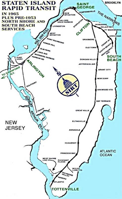
The Staten Island Railway (SIR) is a rapid transit line in the New York City borough of Staten Island. It is owned by the Staten Island Rapid Transit Operating Authority (SIRTOA), a subsidiary of the Metropolitan Transportation Authority, and operated by the New York City Transit Authority Department of Subways. SIR operates 24 hours a day, seven days a week, providing local service between St. George and Tottenville, along the east side of the island. There is currently only one line on the island, and there is no direct rail link between the SIR and the New York City Subway system, but SIR riders do receive a free transfer to New York City Transit bus and subway lines, and the line is included on official New York City Subway maps. Commuters on the railway typically use the Staten Island Ferry to reach Manhattan. The line is accessible from within the Ferry Terminal, and most of its trains are timed to connect with the ferry. In 2022, the system had a ridership of 3,757,700, or about 14,800 per weekday as of the first quarter of 2023.

<span class="mw-page-title-main">Port Ivory, Staten Island</span>

Port Ivory is a coastal area in the northwestern corner of Staten Island, New York City, New York, United States. It is located on Newark Bay near the entrances the Kill van Kull in the east and Arthur Kill in the west. It is bordered by Arlington to the east, Old Place to the south, Newark Bay to the north, and the Arthur Kill to the west.

Staten Island light rail proposals refer to two projects in the New York City borough of Staten Island. These proposals are among the several light rail projects that have been floated in New York City in recent years. Neither proposal was funded in the Metropolitan Transportation Authority's 2015–2019 Capital Plan, but $4 million was allocated to a study for it.

<span class="mw-page-title-main">Richmond Valley station</span> Staten Island Railway station

The Richmond Valley station is a Staten Island Railway station in the neighborhood of Richmond Valley, Staten Island, New York. Located at Richmond Valley Road and Amboy Road on the main line, the station is a mixture of open cut at the north end and grade level at the south end.

Linden Yard is the name of two separate railroad freight yards in Linden, New Jersey, United States. One is owned by the Staten Island Railway (SIR) and the other is managed by Conrail Shared Assets Operations along the Northeast Corridor (NEC) right of way.

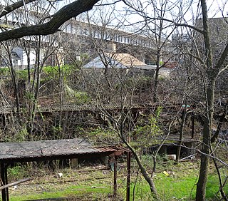
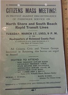
Arlington was a station on the abandoned North Shore Branch of the Staten Island Railway, in Staten Island, New York. Located in an open-cut 5.2 miles (8.4 km) from the St. George Terminal, it had two tracks and one island platform. For a few years before its closure in 1953, it was the western terminus of the North Shore Line; before then, the terminus was the Port Ivory station to the west, though most trains terminated at Arlington. It was located in the Arlington and Mariners Harbor sections of Staten Island, near the Arlington Yard, under the South Avenue overpass, between Arlington Place and Brabant Street.

New Brighton was a station on the abandoned North Shore Branch of the Staten Island Railway. It had two tracks and two side platforms. It was located in the New Brighton section of Staten Island, at the north end of Westervelt Avenue and Richmond Terrace. It was the closest original North Shore station to the Saint George Terminal, 0.7 miles (1.1 km) from the station.

<span class="mw-page-title-main">Sailors' Snug Harbor station</span>

Sailors' Snug Harbor is a former station on the abandoned North Shore Branch of the Staten Island Railway. It had two tracks and two side platforms. Located in the Livingston section of Staten Island north of Richmond Terrace, the station was approximately 1.2 miles (1.9 km) from Saint George Terminal. It is at the northernmost end of the Snug Harbor Cultural Center and Botanical Garden.

<span class="mw-page-title-main">West New Brighton station</span>

West New Brighton, also referred to as West Brighton, is a station on the abandoned North Shore Branch of the Staten Island Railway. It had two side platforms and two tracks. It was located at-grade in the West New Brighton section of Staten Island, north of Richmond Terrace between North Burgher Avenue and Broadway. The station site is 2.4 miles (3.9 km) from the Saint George terminus. No trace of the station exists today.

<span class="mw-page-title-main">Port Richmond station</span>

Port Richmond is a station on the abandoned North Shore Branch of the Staten Island Railway. Located in Port Richmond on a concrete trestle at Park Avenue and Church Street, it has two tracks and an island platform. The station is located approximately 3 miles (4.8 km) from Saint George Terminal.

Harbor Road was a station on the abandoned North Shore Branch of the Staten Island Railway in Mariners Harbor, Staten Island, New York. The station, located under the overpass at the highest point of Harbor Road, was built in an open-cut with two tracks and one island platform. It was located 4.9 miles (7.9 km) from the Saint George terminal. The station was opened during the SIRT grade crossing elimination project of 1935 – 1937. It closed on March 31, 1953, along with the South Beach Branch and the rest of the North Shore Branch. The station was demolished in 2004 during a reconstruction of the rail system for reactivated freight service by the nearby Howland Hook Marine Terminal.

<span class="mw-page-title-main">Tower Hill station (Staten Island Railway)</span>

Tower Hill is a station on the abandoned North Shore Branch of the Staten Island Railway, located in Tower Hill between the Port Richmond and Elm Park neighborhoods. The station lies between Treadwell and Sharpe Avenues about 3.4 miles (5.5 km) from the Saint George Terminal, with two tracks and an island platform. It is one of the three best-preserved stations on the line, the other two being Port Richmond and the line's western terminus at Arlington, in Mariners Harbor.

<span class="mw-page-title-main">Elm Park station (Staten Island Railway)</span>

Elm Park is a station on the abandoned North Shore Branch of the Staten Island Railway (SIR). The station is located in an open cut under the Bayonne Bridge approach in Elm Park, Staten Island, at Morningstar Road between Innis Street and Newark Avenue. It has two tracks and two side platforms. The station is approximately 3.9 miles (6.3 km) from the Saint George terminal of the SIR.

<span class="mw-page-title-main">Livingston station (Staten Island Railway)</span>

Livingston is a former station on the abandoned North Shore Branch of the Staten Island Railway. Located north of Richmond Terrace at Bard Avenue in the Livingston section of Staten Island, it had two tracks and two side platforms. The site is 1.8 miles (2.9 km) from the Saint George terminal. Closed in 1953, the station was demolished, with few remnants of the site today.

<span class="mw-page-title-main">Arlington Yard</span> Freight rail yard on Staten Island, New York City

<span class="mw-page-title-main">Staten Island Tunnel</span> Abandoned and incomplete subway tunnel in New York City

The Staten Island Tunnel is an abandoned, incomplete railway/subway tunnel in New York City. It was intended to connect railways on Staten Island to the BMT Fourth Avenue Line of the New York City Subway, in Brooklyn, via a new crossing under the Narrows. Planned to extend 10,400 feet (3,200 m), the tunnel would have been among the world's longest at the time of its planning, in the late 19th and early 20th centuries.

<span class="mw-page-title-main">South Beach Branch</span> Former railroad branch in Staten Island, New York

The South Beach Branch, also called the East Shore Sub-Division, is an abandoned branch of the Staten Island Railway in New York City, which operated along Staten Island's East Shore from Clifton to Wentworth Avenue. This 4.1-mile (6.6 km) double-tracked branch left the Main Line at 40°37′08″N74°04′18″W, south of the Clifton station, and lay to the east of the Main Line.

<span class="mw-page-title-main">Travis Branch</span> Railroad branch in Staten Island, New York

The Travis Branch is a branch of the Staten Island Railway in New York City, that operates from Arlington Yard to Fresh Kills, which is used for freight transportation along the West Shore, Staten Island.

<span class="mw-page-title-main">History of the Staten Island Railway</span> Aspect of history surrounding the Staten Island Railway

The Staten Island Railway (SIR) is the only rapid transit line in the New York City borough of Staten Island and is operated by the Staten Island Rapid Transit Operating Authority, a unit of the Metropolitan Transportation Authority. The railway was historically considered a standard railroad line, but today only the western portion of the North Shore Branch, which is disconnected from the rest of the SIR, is used by freight and is connected to the national railway system.

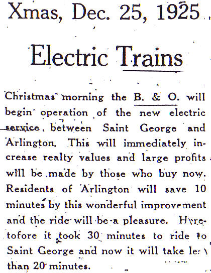
The Baltimore and New York Railway was a railroad line built by the Baltimore and Ohio Railroad (B&O) from Cranford, New Jersey, to the western side of the Arthur Kill Bridge in New Jersey, connecting with the North Shore Branch of Staten Island Rapid Transit. The line was built to provide the B&O access to a terminal in New York City, in Staten Island. Today, the line is used by CSX Transportation for freight trains.

References