Clifton station (Staten Island Railway)

Last updated

Clifton
MTA NYC logo.svg Staten Island Railway station (rapid transit)
Tottenville Local at Clifton, Staten Island Railway.jpg
Tottenville Local arriving at Clifton
General information
LocationBay Street & Townsend Avenue
Clifton, Staten Island
Coordinates 40°37′17″N74°04′17″W / 40.6215°N 74.0715°W / 40.6215; -74.0715 (Clifton Station)
Platforms2 side platforms
Tracks2
ConnectionsAiga bus trans.svg NYCT Bus: S51, S81
Construction
Structure type Embankment / Elevated
Other information
Station code504
History
OpenedApril 23, 1860 [1]
Previous names Vanderbilt's Landing
Vanderbilt Avenue
Services
Preceding station MTA NYC logo.svg Staten Island Railway Following station
Stapleton
toward St. George
NYCS-bull-trans-SIR-Std.svg Grasmere
toward Tottenville
Former services
Preceding station Staten Island Railway Following station
Terminus South Beach Branch Bachmann
Closed 1937
Location
Clifton station (Staten Island Railway)

The Clifton station is a Staten Island Railway station in the neighborhood of Clifton, Staten Island, New York. This station was the original terminal of the Staten Island Railway from 1860 until 1886. The station was known as Vanderbilt's Landing, and was used as a transfer point for passengers going to Manhattan via ferries to South Ferry.

Contents

History

Vanderbilt Avenue station, Clifton, early 20th century Vanderbilt Ave. Station, Clifton, Staten Island (view of red-roofed station with people out front, signs reading Vanderbilt Ave. on platform) (NYPL b15279351-104914).tiff
Vanderbilt Avenue station, Clifton, early 20th century

This station was originally known as Vanderbilt's Landing and opened on April 23, 1860 with the opening of the Staten Island Railway, and was the northern terminal for the line. The line extended from Vanderbilt's Landing to Eltingville. [1] [2] [3] The station was also once known as Vanderbilt Avenue. [4] It also included a ferry port with ferries to Stapleton, Tompkinsville, and South Ferry in Manhattan. [5] The port was replaced by Saint George Terminal on March 7, 1886, which was also the day before Clifton became the northern terminus of the South Beach Branch, a status it maintained until 1953.

In 2019, the Metropolitan Transportation Authority announced that this station would become ADA-accessible as part of the agency's 2020–2024 Capital Program. [6]

Station layout

Clifton station is located at Norwood Avenue and Bay Street on the main line. It is located on an embankment with side platforms and beige canopies.

The SIR's Clifton Yard is next to the northbound track, with yard leads and signals north of Clifton station. South of the station are the remains of the South Beach Branch turnout and a dismantled bridge. [7] To the south, a spur on a pair of I-beams on concrete pillars is the location of an old coal, concrete, and lumber business. South of this station, the SIR main line turns southwest to Tottenville, and no longer runs along the harbor front.

Due to the wide space from trains caused by the platform's curvature, the last car for St. George-bound trains do not open here. [8]

Platform
level
Side platform
Southbound NYCS-bull-trans-SIR-Std.svg toward Tottenville (Grasmere)
NYCS-bull-trans-SIR-Std.svg rush hour express does not stop here
Northbound NYCS-bull-trans-SIR-Std.svg toward St. George (Stapleton)
NYCS-bull-trans-SIR-Std.svg AM rush express does not stop here →
Side platform
GroundStreet levelExit/entrance, buses

Exits

Northbound entrance, Bay Street Clifton Sta SIRT jeh.JPG
Northbound entrance, Bay Street

The north end has exits on both platforms that lead to Bay Street. The southbound platform has winding stairs to Townsend Avenue while the northbound platform has stairs under the right-of-way to Norwood Avenue. The northbound platform also has a second staircase on Bay and Edgewater Streets, which is not present on the southbound side. [9]

On Bay Street (sidewalk level) and facing the platform above, are remains of the original steps up to the old station platform, which became inaccessible when the platforms were extended in the 1990s. On the southbound side there is a station house on the outside, but only a shelter on the platform. Some of the boarded up windows and layout of the brick shelter suggest that it was originally a station house.

Related Research Articles

<span class="mw-page-title-main">Staten Island Railway</span> Rapid transit line in New York City

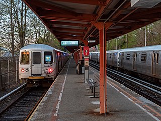
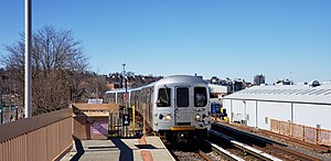
The Staten Island Railway (SIR) is a rapid transit line in the New York City borough of Staten Island. It is owned by the Staten Island Rapid Transit Operating Authority (SIRTOA), a subsidiary of the Metropolitan Transportation Authority, and operated by the New York City Transit Authority Department of Subways. SIR operates 24 hours a day, seven days a week, providing local service between St. George and Tottenville, along the east side of the island. There is currently only one line on the island, and there is no direct rail link between the SIR and the New York City Subway system, but SIR riders do receive a free transfer to New York City Transit bus and subway lines, and the line is included on official New York City Subway maps. Commuters on the railway typically use the Staten Island Ferry to reach Manhattan. The line is accessible from within the Ferry Terminal, and most of its trains are timed to connect with the ferry. In 2023, the system had a ridership of 6,151,400, or about 19,500 per weekday as of the fourth quarter of 2023.

<span class="mw-page-title-main">St. George Terminal</span> Transit center in Staten Island, New York

St. George Terminal is a ferry, railway, bus, and park and ride transit center in the St. George neighborhood of Staten Island, New York City. It is located at the intersection of Richmond Terrace and Bay Street, near Staten Island Borough Hall, SIUH Community Park and Richmond County Supreme Court. St. George is a rare example of a rail-boat connection in the United States.

<span class="mw-page-title-main">Tottenville station</span> Staten Island Railway station

The Tottenville station is a Staten Island Railway rapid transit station in the neighborhood of Tottenville, Staten Island, New York City. Located near Main Street and Arthur Kill Road, it is the southern terminus on the main line and the southernmost railway station in both New York City and New York State.

<span class="mw-page-title-main">Atlantic station (Staten Island Railway)</span>

Atlantic was a Staten Island Railway station in the neighborhood of Tottenville, Staten Island, New York. With the condition of the station having deteriorated after the 1990s, this station, and the Nassau station to the north, were replaced by a new station at Arthur Kill Road. When that station opened in January 2017, Atlantic station closed and subsequently demolished.

<span class="mw-page-title-main">Nassau station</span>

The Nassau station was a Staten Island Railway station located roughly between the neighborhoods of Tottenville and Charleston, in Staten Island, New York. The station was built sometime after 1924 in order to serve the Nassau Smelting & Refining Company, and had a siding so that freight could be transferred to and from the factory. The station platforms were extended in 1971 as part of the modernization of the rail line. However, the condition of the station deteriorated after the 1990s, and this station, along with the Atlantic station to the south, were replaced by a new station at Arthur Kill Road. When that station opened in January 2017, Nassau station closed. The station was subsequently demolished.

<span class="mw-page-title-main">Richmond Valley station</span> Staten Island Railway station

The Richmond Valley station is a Staten Island Railway station in the neighborhood of Richmond Valley, Staten Island, New York. Located at Richmond Valley Road and Amboy Road on the main line, the station is a mixture of open cut at the north end and grade level at the south end.

<span class="mw-page-title-main">Pleasant Plains station</span> Staten Island Railway station

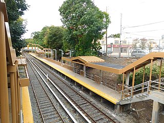
The Pleasant Plains station is an elevated Staten Island Railway station in the neighborhood of Pleasant Plains, Staten Island, New York.

<span class="mw-page-title-main">Huguenot station</span> Staten Island Railway station

The Huguenot station is a Staten Island Railway station in the neighborhood of Huguenot, Staten Island, New York.

<span class="mw-page-title-main">Annadale station</span> Staten Island Railway station

The Annadale station is a Staten Island Railway station in the neighborhood of Annadale, Staten Island, New York.

<span class="mw-page-title-main">Eltingville station</span> Staten Island Railway station

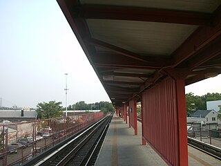
The Eltingville station is an elevated Staten Island Railway station in the neighborhood of Eltingville, Staten Island, New York. It is located at Richmond Avenue on the main line.

<span class="mw-page-title-main">Great Kills station</span> Staten Island Railway station

The Great Kills station is a Staten Island Railway station in the neighborhood of Great Kills, Staten Island, New York. It is located on an open cut west of Giffords Lane and Amboy Road on the main line. It has two side platforms and turquoise blue canopies and walls.

<span class="mw-page-title-main">Oakwood Heights station</span> Staten Island Railway station

The Oakwood Heights station is a Staten Island Railway station in the neighborhood of Oakwood, Staten Island, New York.

<span class="mw-page-title-main">New Dorp station</span> Staten Island Railway station

The New Dorp station is a Staten Island Railway station in the neighborhood of New Dorp, Staten Island, New York. The station became fully compliant with the Americans with Disabilities Act of 1990 in 2023.

<span class="mw-page-title-main">Grant City station</span> Staten Island Railway station

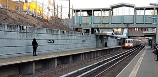
The Grant City station is a Staten Island Railway station in the neighborhood of Grant City, Staten Island, New York.

<span class="mw-page-title-main">Dongan Hills station</span> Staten Island Railway station

The Dongan Hills station is a Staten Island Railway station in the neighborhood of Dongan Hills, Staten Island, New York.

<span class="mw-page-title-main">Stapleton station</span> Staten Island Railway station

The Stapleton station is an elevated Staten Island Railway station in the neighborhood of Stapleton, Staten Island, New York, located at Bay Street and Prospect Street on the main line.

<span class="mw-page-title-main">Tompkinsville station</span> Staten Island Railway station

The Tompkinsville station is a Staten Island Railway station in the neighborhood of Tompkinsville, Staten Island, New York. It is located at Victory Boulevard and Bay Street on the railroad's main line. This is one of two stations on the line that require fare payment to enter or exit, the other being St. George.

<span class="mw-page-title-main">Hylan Boulevard</span> Boulevard in Staten Island, New York

Hylan Boulevard is a major northeast-southwest boulevard in the New York City borough of Staten Island, and the longest street in a single borough in the city. It is approximately 14 miles (23 km) long, and runs from the North Shore neighborhood of Rosebank, then along the entire East Shore, to the South Shore neighborhood of Tottenville. It was renamed in 1923 for New York City mayor John F. Hylan, before which it was known as Southfield Boulevard and the northern segment as Pennsylvania Avenue.

<span class="mw-page-title-main">History of the Staten Island Railway</span>

The Staten Island Railway (SIR) is the only rapid transit line in the New York City borough of Staten Island and is operated by the Staten Island Rapid Transit Operating Authority, a unit of the Metropolitan Transportation Authority. The railway was historically considered a standard railroad line, but today only the western portion of the North Shore Branch, which is disconnected from the rest of the SIR, is used by freight and is connected to the national railway system.

References

  1. 1 2 Irvin Leigh and Paul Matus (December 23, 2001). "SIRT The Essential History". p. 4. Archived from the original on January 4, 2009. Retrieved March 3, 2009.
  2. Poster for opening of Staten Island Railway
  3. "Staten Island News". The New York Times. August 25, 1860. ISSN   0362-4331 . Retrieved November 18, 2015.
  4. "Vanderbilt Avenue Staten Island Rapid Transit station". silive.com. Retrieved February 25, 2018 via Staten Island Museum.
  5. "New York City and Vicinity Rail Map 1860". brooklynrail.net. Retrieved December 24, 2017.
  6. "Press Release - MTA Headquarters - MTA Announces 20 Additional Subway Stations to Receive Accessibility Improvements Under Proposed 2020-2024 Capital Plan". MTA. December 19, 2019. Archived from the original on April 21, 2020. Retrieved December 25, 2019.
  7. Owen, Gary. "Gary Owen's SIRT Page". gretschviking.net. Retrieved March 1, 2009.
  8. "Please use the first three cars to enter or exit the train at the following stations". web.mta.info. Metropolitan Transportation Authority. Retrieved December 24, 2017.
  9. "Map of NYC Subway Entrances". NYC Open Data. City of New York . Retrieved July 10, 2018.

Commons-logo.svg Media related to Clifton (Staten Island Railway station) at Wikimedia Commons