Jonha Falls

Last updated

Jonha Falls
Jonha falls.jpg
India Jharkhand relief map.svg
Red pog.svg
Jonha Falls
Jonha Falls
Location Ranchi district, Jharkhand
Coordinates 23°20′30″N85°36′30″E / 23.34167°N 85.60833°E / 23.34167; 85.60833
Total height43 metres (141 ft)
WatercourseRaru River

The Jonha Falls (also called Gautamdhara Falls) is a waterfall located in Ranchi district in the Indian state of Jharkhand. The best way to reach water fall without using 722 steps of stairs through Jonha Fall Resort Road. You can see beautiful and natural scenes surrounded by Forest, Mountain and Rivers.

Contents

Geography

Jonha Falls
Invisible Square.svg
Mapscaleline.svg
15km
10miles
Red pog.svg
W
E
S
T
B
E
N
G
A
L
Khukhragarh
H
Invisible Square.svg
Sikidiri
R
Invisible Square.svg
Pithuriya
R
Invisible Square.svg
Narkopi
R
Invisible Square.svg
CCL North
Karanpura Area
Invisible Square.svg
Koel
River
Damodar
River
Bhairavi
River
Karkari
River
Kanchi
River
Raru
River
Subarnarekha
River
Getalsud
Dam
D
Invisible Square.svg
Dassam Falls
T
Invisible Square.svg
Jonha Falls
T
Hundru
Falls
T
Invisible Square.svg
Tundul
CT
Invisible Square.svg
Tati
CT
Invisible Square.svg
Ray
CT
Invisible Square.svg
Ratu
CT
Invisible Square.svg
Namkum
N
Invisible Square.svg
Muri
CT
Invisible Square.svg
Khelari
CT
Invisible Square.svg
Kanke
CT
Invisible Square.svg
Irba
CT
Invisible Square.svg
Churi
CT
Invisible Square.svg
Bishrampur
CT
Invisible Square.svg
Bargarwa
CT
Invisible Square.svg
Arsande
CTV
Invisible Square.svg
Ara
CT
Invisible Square.svg
Bundu
M
Invisible Square.svg
Ranchi
M
Invisible Square.svg
Hatia
R
Invisible Square.svg
Tamar
R
Invisible Square.svg
Sonahatu
R
Invisible Square.svg
Silli
R
Invisible Square.svg
Rahe
R
Invisible Square.svg
Ormanjhi
R
Invisible Square.svg
Nagri
R
Invisible Square.svg
Mesra
R
Invisible Square.svg
Mandar
R
Invisible Square.svg
Lapung
R
Invisible Square.svg
Itki
R
Invisible Square.svg
Dakra
R
Invisible Square.svg
Chutupalu
R
Invisible Square.svg
Chanho
R
Invisible Square.svg
Burmu
R
Invisible Square.svg
Bero
R
Invisible Square.svg
Balsokra
R
Invisible Square.svg
Cities, towns and locations in Ranchi district in South Chotanagpur Division
M: municipality, CT: census town, R: rural/ urban centre, N: neighbourhood, T: tourist centre, D: dam, H: historical/ religious centre
Owing to space constraints in the small map, the actual locations in a larger map may vary slightly

Location

Jonha Falls is located at 23°20′30″N85°36′30″E / 23.34167°N 85.60833°E / 23.34167; 85.60833

Note: The map alongside presents some of the notable locations in the district. All places marked in the map are linked in the larger full screen map. Jonha Fall can be seen without using 722 steps  of stairs via Jonha Fall Resort.

The falls

July 2010. Jonha Jalprapat.jpg
July 2010.

Situated at an edge of the Ranchi plateau, the Jonha Falls is an example of a hanging valley falls. The Gunga River hangs over its master stream, Radu River and forms the falls. [1] One has to descend 722 steps to admire the surroundings. [2] Water in the falls drops from a height of 43 metres (141 ft). [3]

The Jonha Falls is an example of a nick point caused by rejuvenation. Knick point, also called a nick point or simply nick, represents breaks in slopes in the longitudinal profile of a river caused by rejuvenation. The break in channel gradient allows water to fall vertically giving rise to a waterfall. [4]

Culture

There is a tourist rest house which encloses a Buddhist shrine with a deity of Lord Gautama Buddha. [2] A temple and an ashram dedicated to Buddha was built atop Gautam Pahar by the sons of Baldeo Das Birla. [5] A fair is organized in Jonha every Tuesday and Saturday. [2]

Transport

The Jonha Falls is 40 kilometres (25 mi) from Ranchi. It is approachable by both road and train. [6] Jonha Station is just 1.5 km from the fall. For travel by road, one has to take the Ranchi-Purulia Road and after travelling for about 20 miles (32 km) one has to travel about 3 miles (4.8 km) off the main road. [7]

See also

Related Research Articles

<span class="mw-page-title-main">Kanke</span> Census Town in Jharkhand, India

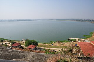
Kanke is a census town in the Kanke CD block in the Ranchi Sadar subdivision of Ranchi district in the Indian state of Jharkhand. Kanke has a large water reservoir called Kanke Dam, which is used to supply water to Ranchi city.

Bundu is a subdivisional town, a notified area, in the Bundu subdivision of Ranchi district in the state of Jharkhand, India. Situated about 40 km from the city of Ranchi and 83 km from the industrial city of Jamshedpur.

Churi is a census town located in the Khelari CD block in the Ranchi Sadar subdivision of Ranchi district in the state of Jharkhand, India.

Tati is a census town in the Namkum CD block in the Ranchi Sadar subdivision of Ranchi district in the Indian state of Jharkhand.

Sadni Falls is a waterfall located about 3 kilometres (1.9 mi) from Rajadera village in Gumla district in the Indian state of Jharkhand.

<span class="mw-page-title-main">Dassam Falls</span> Waterfalls in Ranchi, Jharkhand

The Dassam Falls is a waterfall located near Taimara village in Bundu police station of Ranchi district in the Indian state of Jharkhand.

<span class="mw-page-title-main">Hundru Falls</span> Waterfall on the Subarnarekha River in Jharkhand, India

The Hundru Falls is a waterfall located in Ranchi district in the Indian state of Jharkhand. It is the 34th highest waterfall in India. It is one of the most famous tourist places in the region.

<span class="mw-page-title-main">Panchghagh Falls</span> Waterfall in Jharkhand, India

Panchghagh Falls is a waterfall located in Khunti district in the Indian state of Jharkhand.

Nagri is a village in the Nagri CD block in the Ranchi Sadar subdivision of the Ranchi district in the Indian state of Jharkhand.

Sonahatu is a village in the Sonahatu CD block in the Bundu subdivision of the Ranchi district in the Indian state of Jharkhand.

Silli is a village in the Silli CD block in the Ranchi Sadar subdivision of the Ranchi district in the Indian state of Jharkhand.

Rahe is a village in the Rahe CD block in the Bundu subdivision of the Ranchi district in the Indian state of Jharkhand.

Dakra is an inhabited location not identified in 2011 census as a separate place in the Khelari CD block in the Ranchi Sadar subdivision of the Ranchi district in the Indian state of Jharkhand.

Namkum is a neighbourhood of Ranchi in the Ranchi Sadar subdivision of the Ranchi district in the Indian state of Jharkhand.

Arsande is a census town in the Kanke CD block in the Ranchi Sadar subdivision of the Ranchi district in the Indian state of Jharkhand.

Ara is a census town in the Namkum CD block in the Ranchi Sadar subdivision of the Ranchi district in the Indian state of Jharkhand.

Bargawan {also called Bargawan} is a census town in the Namkum CD block in the Ranchi Sadar subdivision of the Ranchi district in the Indian state of Jharkhand.

Tundul is a census town in the Nagri CD block in the Ranchi Sadar subdivision of the Ranchi district in the Indian state of Jharkhand.

<span class="mw-page-title-main">Chutupalu</span> Village in Jharkhand, India

Chutupalu is a village in the Ormanjhi CD block in the Ranchi Sadar subdivision of the Ranchi district in the Indian state of Jharkhand.

Pithoria is a village in the Kanke CD block in the Ranchi Sadar subdivision of the Ranchi district in the Indian state of Jharkhand.

References

  1. Bharatdwaj, K (2006). Physical Geography: Hydrosphere By K. Bharatdwaj. ISBN   9788183561679 . Retrieved 2 May 2010.
  2. 1 2 3 "Jonha Falls". must see India. Retrieved 29 April 2010.
  3. "High and dry- Dasam drained, Hundru a trickle". The Telegraph 29 April 2009. Archived from the original on 3 February 2013. Retrieved 29 April 2010.
  4. A.Z.Bukhari (2005). Encyclopedia of nature of geography. ISBN   9788126124435 . Retrieved 11 July 2010.{{cite book}}: |work= ignored (help)[ permanent dead link ]
  5. "Waterfall Around Ranchi". exoticindia. Archived from the original on 8 July 2011. Retrieved 29 April 2010.
  6. "Johna Falls". Ranchi district administration. Retrieved 29 April 2010.
  7. Sir John Houlton, Bihar, the Heart of India, p. 144, Orient Longmans, 1949