Bishrampur, Jharkhand

Last updated

Bishrampur
India Jharkhand location map.svg
Red pog.svg
Bishrampur
Location in Jharkhand, India3
India location map 3.png
Red pog.svg
Bishrampur
Bishrampur (India)
Coordinates: 23°40′38″N85°00′15″E / 23.6771°N 85.0043°E / 23.6771; 85.0043 Coordinates: 23°40′38″N85°00′15″E / 23.6771°N 85.0043°E / 23.6771; 85.0043
CountryFlag of India.svg  India
State Jharkhand
District Ranchi
Government
  Type Federal democracy
Area
  Total5.79 km2 (2.24 sq mi)
Population
 (2011)
  Total4,487
  Density770/km2 (2,000/sq mi)
Languages (*For language details see Khelari block#Language and religion)
  Official Hindi, Urdu
Time zone UTC+5:30 (IST)
PIN
829210
Telephone/ STD code 06530
Vehicle registration JH 01
Literacy75.97%
Lok Sabha constituency Ranchi
Vidhan Sabha constituency Kanke
Website ranchi.nic.in

Bishrampur is a census town in the Khelari CD block in the Ranchi Sadar subdivision of the Ranchi district in the Indian state of Jharkhand.

Contents

Geography

Cities, towns and locations in Ranchi district in South Chotanagpur Division
M: municipality, CT: census town, R: rural/ urban centre, N: neighbourhood, T: tourist centre, D: dam, H: historical/ religious centre
Owing to space constraints in the small map, the actual locations in a larger map may vary slightly

Location

Bishrampur is located at 23°40′38″N85°00′15″E / 23.6771°N 85.0043°E / 23.6771; 85.0043 .

Area overview

The map alongside shows a part of the Ranchi plateau, most of it at an average elevation of 2,140 feet above sea level. Only a small part in the north-eastern part of the district is the lower Ranchi plateau, spread over Silli, Rahe, Sonahatu and Tamar CD blocks, at an elevation of 500 to 1,000 feet above sea level. There is a 16 km long ridge south-west of Ranchi. There are isolated hills in the central plateau. The principal river of the district, the Subarnarekha, originates near Ratu, flows in an easterly direction and descends from the plateau, with a drop of about 300 feet at Hundru Falls. Subarnarekha and other important rivers are marked on the map. The forested area is shaded in the map. [1] A major part of the North Karanpura Area and some fringe areas of the Piparwar Area of the Central Coalfields Limited, both located in the North Karanpura Coalfield, are in Ranchi district. [2] [3] There has been extensive industrial activity in Ranchi district, since independence. [4] Ranchi district is the first in the state in terms of population. 8.83% of the total population of the state lives in this district - 56.9% is rural population and 43.1% is urban population. [5]

Note: The map alongside presents some of the notable locations in the district. All places marked in the map are linked in the larger full screen map.

Demographics

According to the 2011 Census of India, Bishrampur had a total population of 4,487, of which 2,321 (52%) were males and 2,166 (48%) were females. Population in the age range 0–6 years was 663. The total number of literate persons in Bishrampur was 2,905 (75.97% of the population over 6 years). [6]

Infrasturcture

According to the District Census Handbook 2011, Ranchi, Bishrampur covered an area of 5.79 km2. Among the civic amenities, it had 9 km roads with open drains, the protected water supply involved uncovered well, tap water from untreated sources, river infiltration gallery. It had 771 domestic electric connections. Among the medical facilities, it had 1 hospital, 6 dispensaries, 6 health centres, 8 family welfare centre, 8 maternity and child welfare centres, 8 maternity homes, 3 nursing homes, 1 medicine shop. Among the educational facilities it had 6 primary schools, 6 middle schools, 2 secondary schools, the nearest senior secondary school at Bukbuka 2 km away. An important commodity it produced was coal. It had the branch office of 1 nationalised bank. [7]

Economy

The projects of the North Karanpura Area of Central Coalfields Ltd. in North Karanpura Coalfield are: Churi underground, Dakra Bukbuka opencast, K.D.H. opencast, Karkatta opencast, Rohini opencast, Purnadih opencast. [8]

Education

Uttari Karnpura Shramik Mahavidyalaya was established at Dakra in 1990. [9] [10] [11]

Related Research Articles

<span class="mw-page-title-main">Kanke</span> Census Town in Jharkhand, India

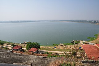
Kanke is a census town in the Kanke CD block in the Ranchi Sadar subdivision of Ranchi district in the Indian state of Jharkhand. Kanke has a large water reservoir called Kanke Dam, which is used to supply water to Ranchi city.

Bundu is a subdivisional town, a notified area, in the Bundu subdivision of Ranchi district in the state of Jharkhand, India. Situated about 40 km from the city of Ranchi and 83 km from the industrial city of Jamshedpur.

Churi is a census town located in the Khelari CD block in the Ranchi Sadar subdivision of Ranchi district in the state of Jharkhand, India.

Khalari is a census town in the Khelari CD block in the Ranchi Sadar subdivision of the Ranchi district in the Indian State of Jharkhand. It is an area rich in coal.

Khelari is a community development block that forms an administrative division in the Ranchi Sadar subdivision of the Ranchi district, Jharkhand state, India.

Burmu is a village in the Burmu CD block in the Ranchi Sadar subdivision of the Ranchi district in the Indian state of Jharkhand.

Nagri is a village in the Nagri CD block in the Ranchi Sadar subdivision of the Ranchi district in the Indian state of Jharkhand.

Sonahatu is a village in the Sonahatu CD block in the Bundu subdivision of the Ranchi district in the Indian state of Jharkhand.

Lapung is a village in the Lapung CD block in the Ranchi Sadar subdivision of the Ranchi district in the Indian state of Jharkhand.

Chanho is a village in the Chanho CD block in the Ranchi Sadar subdivision of the Ranchi district in the Indian state of Jharkhand.

Mandar is a village in the Mandar CD block in the Ranchi Sadar subdivision of the Ranchi district in the Indian state of Jharkhand.

Silli is a village in the Silli CD block in the Ranchi Sadar subdivision of the Ranchi district in the Indian state of Jharkhand.

Rahe is a village in the Rahe CD block in the Bundu subdivision of the Ranchi district in the Indian state of Jharkhand.

Dakra is an inhabited location not identified in 2011 census as a separate place in the Khelari CD block in the Ranchi Sadar subdivision of the Ranchi district in the Indian state of Jharkhand.

Namkum is a neighbourhood of Ranchi in the Ranchi Sadar subdivision of the Ranchi district in the Indian state of Jharkhand.

Ray is a census town in the Khelari CD block in the Ranchi Sadar subdivision of the Ranchi district in the Indian state of Jharkhand.

Ara Gate is a census town in the Namkum CD block in the Ranchi Sadar subdivision of the Ranchi district in the Indian state of Jharkhand.

Bargarwa {also called Barganwa} is a census town in the Namkum CD block in the Ranchi Sadar subdivision of the Ranchi district in the Indian state of Jharkhand.

<span class="mw-page-title-main">Chutupalu</span> Village in Jharkhand, India

Chutupalu is a village in the Ormanjhi CD block in the Ranchi Sadar subdivision of the Ranchi district in the Indian state of Jharkhand.

Narkopi is a village in the Bero CD block in the Ranchi Sadar subdivision of the Ranchi district in the Indian state of Jharkhand.

References

  1. "District Census Handbook, Ranchi, Series 21, Part XII A" (PDF). Pages 10-11: Physiography, Drainage. Directorate of Census Operations Jharkhand. Retrieved 19 September 2021.
  2. "Central Coalfields Limited". Areas – North Karanpura. CCL. Retrieved 19 September 2021.
  3. "Central Coalfields Limited". Areas – Piparwar. CCL. Retrieved 19 September 2021.
  4. "District Census Handbook, Ranchi, Series 21, Part XII A" (PDF). Page 14: Industry. Directorate of Census Operations Jharkhand. Retrieved 19 September 2021.
  5. "District Census Handbook, Ranchi, Series 21, Part XII A" (PDF). Pages 10-11: Physiography, Drainage. Directorate of Census Operations Jharkhand. Retrieved 19 September 2021.
  6. "District Census Handbook, Ranchi , Series 21, Part XII B" (PDF). Rural PCA-C.D. blocks wise Village Primary Census Abstract, location no. 373458, page 28-29. Directorate of Census Operations Jharkhand. Retrieved 11 September 2021.
  7. "District Census Handbook Ranchi, Census of India 2011, Series 21, Part XII A" (PDF). Pages 675-681. Directorate of census Operations, Jharkhand. Retrieved 10 September 2021.
  8. "Central Coalfields Limited". Areas – North Karanpura. CCL. Retrieved 27 December 2020.
  9. "Uttari Karnpura Shramik Mahavidyalaya". UKSM. Retrieved 7 September 2021.
  10. "Uttar Karanpur Shramik Mahavidyalaya". Shiksha. Retrieved 7 September 2021.
  11. "Affiliated Colleges". Ranchi University. Retrieved 9 September 2021.