Nagfeni

Last updated

Nagfeni
Village
India Jharkhand location map.svg
Red pog.svg
Nagfeni
Location in Jharkhand, India
India location map 3.png
Red pog.svg
Nagfeni
Nagfeni (India)
Coordinates: 23°07′31″N84°40′53″E / 23.125324°N 84.681267°E / 23.125324; 84.681267
CountryFlag of India.svg  India
State Jharkhand
District Gumla
Government
  Type Federal democracy
Population
 (2011)
  Total1,700
Languages *
   Official Hindi, Urdu
Time zone UTC+5:30 (IST)
PIN
835224
Telephone/ STD code 06523
Vehicle registration JH 07
Literacy75.07%
Lok Sabha constituency Lohardaga
Vidhan Sabha constituency Sisai
Website gumla.nic.in

Nagfeni is a village in the Sisai CD block in the Gumla subdivision of the Gumla district in the Indian state of Jharkhand.

Contents

Geography

Nagfeni
Invisible Square.svg
Mapscaleline.svg
15km
10miles
Red pog.svg
C
H
H
A
T
T
I
S
G
A
R
H
North Karo
River
Sankh River
South Koel
River
Palkot
Wildlife
Sanctuary
T
Invisible Square.svg
Sadni
Falls
T
Invisible Square.svg
Nagfeni
H
Navratangarh
H
Invisible Square.svg
Marda
H
Invisible Square.svg
Serangdag
B
Invisible Square.svg
Jalim
B
Invisible Square.svg
Gurdari
B
Invisible Square.svg
Toto
CT
Invisible Square.svg
Ghaghra
CT
Invisible Square.svg
Gumla
M
Invisible Square.svg
Sisai
R
Invisible Square.svg
Raidih
R
Invisible Square.svg
Palkot
R
Invisible Square.svg
Kamdara
R
Invisible Square.svg
Jari
R
Invisible Square.svg
Dumri
R
Invisible Square.svg
Chainpur
R
Invisible Square.svg
Bishunpur
R
Invisible Square.svg
Bharno
R
Invisible Square.svg
Cities, towns and locations in Gumla district in South Chotanagpur Division
M: municipality, CT: census town, R: rural/ urban centre, H: historical/ religious centre, T: tourist centre, B: Bauxite mining centre
Owing to space constraints in the small map, the actual locations in a larger map may vary slightly

Location

Nagfeni is located at 23°07′31″N84°40′53″E / 23.125324°N 84.681267°E / 23.125324; 84.681267

Area overview

The map alongside presents a rugged area, consisting partly of flat-topped hills called pat and partly of an undulating plateau, in the south-western portion of Chota Nagpur Plateau. Three major rivers – the Sankh, South Koel and North Karo - along with their numerous tributaries, drain the area. The hilly area has large deposits of Bauxite. 93.7% of the population lives in rural areas. [1] [2]

Note: The map alongside presents some of the notable locations in the district. All places marked in the map are linked in the larger full screen map.

Demographics

According to the 2011 Census of India, Nagfeni had a total population of 1,700, of which 855 (50%) were males and 845 (50%) were females. Population in the age range 0–6 years was 300. The total number of literate persons in Nagfeni was 1,051 (75.07% of the population over 6 years). [3]

(*For language details see Sisai block#Language and religion)

Culture

There is a big rock in the shape of snake 'nag'. According to a popular legend, Maharaj Mutuk Nath Sah Deo was saved by a nag or cobra. He founded the Nagvanshi dynasty, that held sway over parts of the area now known as Jharkhand for many centuries. [4] [5]

Nagfeni is situated 14 km from Gumla on National Highway 43 (old numbering NH 23). The temples of Jagannath, Subhadra and Balarama were built in 1761. On the occasion of Makar Sankranti, thousands of devotees have a bath in the South Koel River before entering the temples on the banks of the river. [6]

Ratha Yatra celebrated in the month of Ashadha (June–July) is an important event of the village. [4]

Related Research Articles

Gumla is a city which is the district headquarters in the Gumla subdivision of the Gumla district in the state of Jharkhand, India.

<span class="mw-page-title-main">Ghaghra</span> Census Town in Jharkhand, India

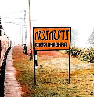
Ghaghra is a census town in the Ghaghra CD block in the Gumla subdivision of the Gumla district in the Indian state of Jharkhand.

<span class="mw-page-title-main">Navratangarh</span> Historic site in Jharkhand, India

Navratangarh (Doisagarh) was one of the capitals of the Nagvanshi dynasty, who ruled parts of what is now the state of Jharkhand, India. It is located in Sisai block of Gumla district. It is said that king Durjan Shah shifted his capital from Khukhragarh to Navratangarh. He constructed the fort between 1636 and 1639. The palace was a five-storeyed structure with its "water-gate" and garh-khai (moat) arrangement. It has a kiaclmy (court), a treasury house and a prison-cell with its underground dungeon. It was declared national heritage in 2009.

<span class="mw-page-title-main">Palkot Wildlife Sanctuary</span>

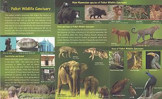
Palkot Wildlife Sanctuary is a wildlife sanctuary located near Palkot. It is spread over Gumla and Simdega districts of Jharkhand in India.

Bishunpur is a village in the Bishunpur CD block in the Gumla subdivision of the Gumla district in the Indian state of Jharkhand.

Sisai is a village in the Sisai CD block in the Gumla subdivision of the Gumla district in the Indian state of Jharkhand.

Bharno is a village in the Bharno CD block in the Gumla subdivision of the Gumla district in the Indian state of Jharkhand.

Kamdara is a village in the Kamdara CD block in the Basia subdivision of the Gumla district in the Indian state of Jharkhand.

Basia is a village in the Basia CD block in the Basia subdivision of the Gumla district in the Indian state of Jharkhand.

Chainpur is a village in the Chainpur CD block in the Chainpur subdivision of the Gumla district in the Indian state of Jharkhand.

Dumri is a village in the Dumri CD block in the Chainpur subdivision of the Gumla district in the Indian state of Jharkhand.

Jari is a village in the Albert Ekka (Jari) CD block in the Chainpur subdivision of the Gumla district in the Indian state of Jharkhand.

Raidih is a village in the Raidih CD block in the Gumla subdivision of the Gumla district in the Indian state of Jharkhand.

Palkot is a village in the Palkot CD block in the Basia subdivision of the Gumla district in the Indian state of Jharkhand.

Jalim is a village/ Bauxite mining site in the Bishunpur CD block in the Bishnupur subdivision of the Gumla district in the Indian state of Jharkhand.

Gurdari is a village/ Bauxite mining centre in the Bishunpur CD block in the Gumla subdivision of the Gumla district in the Indian state of Jharkhand.

Serangdag is a village/ Bauxite mining centre in the Ghaghra CD block in the Gumla subdivision of the Gumla district in the Indian state of Jharkhand.

Marda is a village in the Raidih CD block in the Gumla subdivision of the Gumla district in the Indian state of Jharkhand.

Toto is a census town in the Gumla CD block in the Gumla subdivision of the Gumla district in the Indian state of Jharkhand.

Chainpur subdivision is an administrative subdivision of the Gumla district in the South Chotanagpur division in the state of Jharkhand, India.

References

  1. "District Census Handbook, Gumla, Series 21, Part XII A" (PDF). page 7: Natural Divisions, Page 38: 2011 Census Findings–Population and its Distribution. Directorate of Census Operations Jharkhand. Retrieved 29 October 2021.
  2. "Chota Nagpur plateau". Britannica. Retrieved 29 October 2021.
  3. "District Census Handbook, Gumla, Series 21, Part XII B" (PDF). Rural PCA-C.D. blocks wise Village Primary Census Abstract, location no. 375686, pages 84-85. Directorate of Census Operations Jharkhand. Retrieved 25 October 2021.
  4. 1 2 "District Census Handbook, Gumla, Series 21, Part XII A" (PDF). Pages 67-68: Brief Description of places of Religious, Historical and Archaeological importance in villages and places of Tourist interest in the Towns of the District. Directorate of Census Operations Jharkhand. Retrieved 25 October 2021.
  5. "Brief Industrial Profile of Gumla district" (PDF). Page 4: Tourist Place. MSME Development Institute Ranchi. Retrieved 25 October 2021.
  6. "Thousands of faithful visit Nagfeni". Times of India, 15 January 2013. Retrieved 25 October 2021.