The geography of Ukraine varies greatly from one region of the country to another, with the majority of the country lying within the East European Plain. Ukraine is the second-largest European country, after Russia. Its various regions have diverse geographic features ranging from highlands to lowlands, as well as climatic range and a wide variety in hydrography.

Transport in Ukraine includes ground transportation, water, air transportation, and pipelines. The transportation sector accounts for roughly 11% of the country's gross domestic product and 7% of total employment.

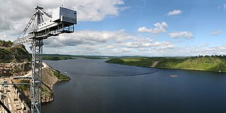
The Dnieper, also called Dnipro, is one of the major transboundary rivers of Europe, rising in the Valdai Hills near Smolensk, Russia, before flowing through Belarus and Ukraine to the Black Sea. Approximately 2,200 km (1,400 mi) long, with a drainage basin of 504,000 square kilometres (195,000 sq mi), it is the longest river of Ukraine and Belarus and the fourth-longest river in Europe, after the Volga, Danube, and Ural rivers.

The Pripyat or Prypiat is a river in Eastern Europe, approximately 761 km (473 mi) long. It flows east through Ukraine, Belarus, and Ukraine again, draining into the Dnieper.

The Seversky Donets or Siverskyi Donets, usually simply called the Donets, is a river on the south of the East European Plain. It originates in the Central Russian Upland, north of Belgorod, flows south-east through Ukraine and then again through Russia to join the river Don, about 100 km (62 mi) from the Sea of Azov. The Donets is the fourth-longest river in Ukraine, and the largest in eastern Ukraine, where it is an important source of fresh water. It gives its name to the Donets Basin, known commonly as the Donbas, an important coal-mining and industrial region in Ukraine.
The Bug or Western Bug is a major river in Eastern Europe that flows through Belarus, Poland, and Ukraine, with a total length of 774 kilometres (481 mi). A tributary of the Narew, the Bug forms part of the border between Belarus and Poland for 178 kilometres (111 mi) and part of the border between Ukraine and Poland for 185 kilometres (115 mi).

The Desna is a river in Russia and Ukraine, a major left-tributary of the Dnieper. Its name means "right hand" in the Old East Slavic language. It has a length of 1,130 km (702 mi), and its drainage basin covers 88,900 km2 (34,324 sq mi).
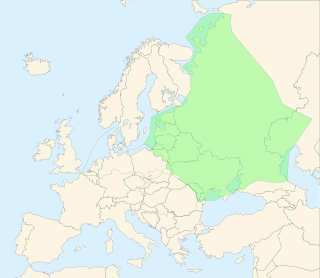
The East European Plain is a vast interior plain extending east of the North European Plain, and comprising several plateaus stretching roughly from 25 degrees longitude eastward. It includes Volhynian-Podolian Upland on its westernmost fringe, the Central Russian Upland, and, on the eastern border, encompasses the Volga Upland. The plain includes also a series of major river basins such as the Dnepr Basin, the Oka–Don Lowland, and the Volga Basin. At the southeastern point of the East European Plain are the Caucasus and Crimean mountain ranges. Together with the North European Plain, and covering the Baltic states, European Russia, Belarus, Ukraine, Moldova, southeastern Romania, and, at its southernmost point, the Danubian Plain in Northern Bulgaria, it constitutes the majority of the Great European Plain, the greatest mountain-free part of the European landscape. The plain spans approximately 4,000,000 km2 (2,000,000 sq mi) and averages about 170 m (560 ft) in elevation. The highest point of the plain, located in the Valdai Hills, is 346.9 metres (1,138.1 ft).
The Bureya is a south-flowing, left tributary of the Amur river in Russia. It is 623 kilometres (387 mi) long, and has a drainage basin of 70,700 square kilometres (27,300 sq mi). Its name comes from the Evenk word birija, meaning river.

The Zarubintsy or Zarubinets culture was a culture that, from the 3rd century BC until the 1st century AD, flourished in the area north of the Black Sea along the upper and middle Dnieper and Pripyat Rivers, stretching west towards the Southern Bug river. Zarubintsy sites were particularly dense between the Rivers Desna and Ros as well as along the Pripyat river. It was identified around 1899 by the Czech-Ukrainian archaeologist Vikentiy Khvoyka and is now attested by about 500 sites. The culture was named after finds of cremated remains in the village of Zarubyntsi on the Dnieper.

Ivankovo Reservoir or Ivankovskoye Reservoir, informally known as the Moscow Sea, is the uppermost reservoir on the Volga, in Moscow and Tver Oblasts of Russia, located some 130 km (81 mi) north of Moscow. The dam of the reservoir is situated in the town of Dubna. The town of Konakovo is located on its southern coast. The reservoir is connected to the Moskva by the Moscow Canal, and is the principal fresh water source for the city of Moscow. Its area is 327 km2 (126 sq mi), and the area of its drainage basin is 41,000 km2 (16,000 sq mi).

The racer goby is a species of goby native to fresh, sometimes brackish, waters, of the Black Sea basin. It is a Ponto-Caspian relict species. The species is placed a monotypic genus, Babka, which was once considered a subgenus of genus Neogobius, but was then elevated to genus-status based on the molecular analysis.

Muravsky Trail or Murava Route was an important trade route and an invasion route of the Crimean Nogays during the Russo-Crimean Wars of the 16th and early 17th centuries. As described in the Book to the Great Chart of Muscovy (1627), the route went north from the Tatar fortress of Or Qapı (Perekop), the gateway of the Crimean peninsula, east of the Dnieper, to the Russian fortress of Tula, 193 km south of Moscow.
The Ubort is a river in Zhytomyr Oblast (Ukraine) and Gomel Region (Belarus), a right tributary to the Pripyat in the Dnieper river basin. It is 292 kilometres (181 mi) long, and has a drainage basin of 5,820 square kilometres (2,250 sq mi).
Caspiosoma caspium is a species of Ponto-Caspian goby native to the deltas of rivers inflows to the north-western Black Sea: Dnieper up to Berislav, also in the Dnieper-Bug Estuary and Berezan Estuary, Danube, Dniester with the estuary, Cuciurgan Reservoir. Found in the delta of the Don River, Volga, central and northern parts of the Caspian Sea and rivers flowing into the Sea of Azov. It can be found at depths of from 2 to 8 metres. This species can reach a length of 4.5 centimetres (1.8 in) TL. It is currently the only known member of its genus.

The Kiyevka is a river in Primorsky Krai, Russia.

Voronizh is an urban-type settlement in Shostka Raion, Sumy Oblast, Ukraine. It is located on the banks of the Osota, a left tributary of the Desna, in the drainage basin of the Dnieper. Voronizh belongs to Shostka urban hromada, one of the hromadas of Ukraine. Population: 6,560.

The Krasna is a river in Ukraine, a tributary on the left bank of the Donets River, within the Don River Basin.
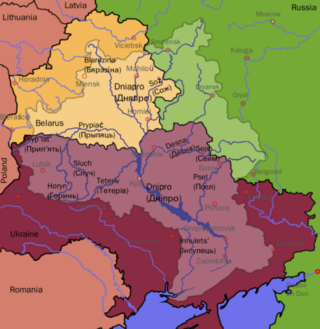
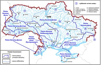
The Dnieper Basin is the drainage basin of the Dnieper River, covering an area of 531,817 square kilometres (205,336 sq mi). Its water resources compose around 80% of the total for all Ukraine.
 The Dnieper River passes through many cities — notably Kyiv, the capital of Ukraine. In Kyiv, more than seven bridges cross the river.
 A map of the Southern Buh flowing through Ukraine (in Lithuanian).
 Kalmius river, Donetsk