List of mountains, peaks and hills in Hong Kong

Last updated

The following is a list of mountains, peaks and hills in Hong Kong .

Contents

In the romanisation system used by the Hong Kong Government known as Standard Romanisation, 'shan' and 'leng' are the transliterations of the Cantonese words for 'mount' (山) and 'ridge' (嶺), respectively. 'Toi', 'kong', 'fung' and 'koi' also correspond to 'mount' in English and 'teng' corresponds to 'peak'. It is this system which is used in the list below.

Highest peaks of Hong Kong

RankNameHeight (m)Country parkLocationNotes
1 Tai Mo Shan 957 Tai Mo Shan Country Park Central New Territories MacLehose Trail Section 8. The actual peak is inside an army base and not accessible to the public.
2 Lantau Peak
(Fung Wong Shan)
934 Lantau South Country Park Central Lantau Island Highest publicly accessible summit. Lantau Trail Section 3
3 Sunset Peak
(Tai Tung Shan)
869 Lantau South Country Park Southern Lantau Island Lantau Trail Section 2
4 Sze Fong Shan 785 Tai Mo Shan Country Park Central New Territories MacLehose Trail Section 8
5 Miu Ko Toi 779 Tai Mo Shan Country Park Central New Territories Second highest peak on Tai Mo Shan [1]
6 Wo Yeung Shan 767 Tai Mo Shan Country Park Central New Territories
7 Lin Fa Shan 766 Lantau North Country Park Central Lantau Island Lantau Trail Section 2
8 Nei Lak Shan 754 Lantau North Country Park Southern Lantau Island Lantau Trail Section 3
9 Yi Tung Shan 749 Lantau North Country Park Eastern Lantau Island Lantau Trail Section 2
10 Ma On Shan 702 Ma On Shan Country Park Eastern New Territories
11 Yin Ngam Teng 679 Tai Mo Shan Country Park Central New Territories
12 The Hunch Backs
(Ngau Ngak Shan)
677 Ma On Shan Country Park Eastern New Territories
13 Wo Kong Tong (lower)656 Tai Mo Shan Country Park Central New Territories
14 Grassy Hill 647 Tai Mo Shan Country Park Central New Territories
15 Wong Leng 639 Pat Sin Leng Country Park Northeastern New Territories
16 Buffalo Hill 606 Ma On Shan Country Park Eastern New Territories
17 West Buffalo Hill 604 Ma On Shan Country Park Eastern New Territories
18 Kowloon Peak
(Fei Ngo Shan)
602 Ma On Shan Country Park Eastern Kowloon
19 Shun Yeung Fung 591 Pat Sin Leng Country Park Northeastern New Territories Part of Pat Sin Leng.
20 Tiu Shau Ngam 589 Ma On Shan Country Park Eastern New Territories
21 Chau Ma Kong 588 Tai Mo Shan Country Park Eastern New Territories
22= Cheung Shan 585 Ma On Shan Country Park Eastern Kowloon Also known as Middle Hill
22= Lo Tin Teng 585 Lam Tsuen Country Park Northwestern New Territories
24 Castle Peak 583NoneWestern New Territories west of Tuen Mun Also known as Ching Shan or Pui To Shan
25 Lin Fa Shan 579 Tai Lam Country Park Tsuen Wan District
26 Tate's Cairn 577 Ma On Shan Country Park Northeastern Kowloon Also known as Tai Lo Shan.
27 Kai Kung Leng (Tai Lo Tin)572 Lam Tsuen Country Park Northwestern New Territories
28 Tai To Yan 566 Lam Tsuen Country Park Northwestern New Territories
29 Wong Chuk Shan [2] 560 Ma On Shan Country Park Eastern New Territories
30Ngoc Yiu Chiu Tin

鱷魚朝天

559 Tai Lam Country Park Tsuen Wan District Not included before Nov 2023, but measured to have > 30m of prominence, an International standard for an independent mountain. In English its name is "Crocodile towards the Sky".
31= Victoria Peak 552 Pok Fu Lam Country Park Hong Kong Island Named for British monarch Queen Victoria; also known as Mount Austin (named for former Colonial Secretary John Gardiner Austin), and locally as The Peak. The Peak was once a volcano.
31= Kwun Yam Shan 552 Tai Mo Shan Country Park Central New Territories
33 Lai Pek Shan 550 Pat Sin Leng Country Park Northeastern New Territories
34 Tung Shan 544 Ma On Shan Country Park Eastern Kowloon
35 Chung Li Fung 543 Pat Sin Leng Country Park Northeastern New Territories Part of Pat Sin Leng.
36 Shek Nga Shan 540 Ma On Shan Country Park Eastern New Territories
37 Kau Nga Ling 539 Lantau South Country Park Southern Lantau Island
38 Pyramid Hill 536 Ma On Shan Country Park Eastern New Territories Also known as Tai Kam Chung.
39 Tung Yeung Shan 533 Ma On Shan Country Park Northeastern Kowloon
40= Needle Hill 532 Shing Mun Country Park Central New Territories Also known as Cham Shan.
40= Mount Parker 532 Tai Tam Country Park Hong Kong Island
42= Kao Lao Fung 530 Pat Sin Leng Country Park Northeastern New Territories Part of Pat Sin Leng.
42= Kuai Li Fung 530 Pat Sin Leng Country Park Northeastern New Territories Part of Pat Sin Leng.
44= Pok To Yan 529 Lantau South Country Park Southern Lantau Island
44=Ping Fung Shan 屏風山529 Pat Sin Leng Country Park Northeastern New Territories
46 Fu Yung Pit 515 Ma On Shan Country Park Northeastern Kowloon
47 Hsien Ku Fung 514 Pat Sin Leng Country Park Northeastern New Territories Part of Pat Sin Leng
48= Sheung Tsz Fung 510 Pat Sin Leng Country Park Northeastern New Territories Part of Pat Sin Leng
48= Tsao Kau Fung 510 Pat Sin Leng Country Park Northeastern New Territories Part of Pat Sin Leng
50 Kau Keng Shan 507 Tai Lam Country Park Western New Territories
51Luk Ngo Leng

轆牛嶺

503 Tai Lam Country Park Tsuen Wan District Not included before Nov 2023, but measured to have > 80m of prominence, more than the 30m International standard for an independent mountain.
52 Mount Kellett 501 Aberdeen Country Park Hong Kong Island named after British naval officer and explorer Henry Kellett
53 Lion Rock 495 Lion Rock Country Park Northern Kowloon
54 High West 494 Pok Fu Lam Country Park Hong Kong Island
55 Sze Tse Tau Shan 494 Lantau South Country Park Southern Lantau Island
56 Robin's Nest 492 Robin's Nest Country Park Northern New Territories Also known as Hung Fa Leng ('Red Flower Ridge').
57 Ling Wui Shan 490 Lantau South Country Park Lantau Island
58= Choi Wo Fung 489 Pat Sin Leng Country Park Northeastern New Territories Part of Pat Sin Leng.
58= Hung Fa Chai 489 Robin's Nest Country Park Northeastern New Territories Also known on old Admiralty charts as Ben Nevis.
60 Temple Hill 488 Lion Rock Country Park line of mountains dividing Sha Tin from Kowloon Also known as Tsz Wan Shan.
61 Kwai Tau Leng 486 Pat Sin Leng Country Park Northeastern New Territories
62 Por Kai Shan 482 Lantau North Country Park southeast of Tung Chung and facing Urmston Road
63 Shek Uk Shan 481 Sai Kung West Country Park Sai Kung, New Territories
64 Pak Tai To Yan 480 Lam Tsuen Country Park Northwestern New Territories
65= Muk Yue Shan 479 Lantau North Country Park on Lantau Island north side of Shek Pik Reservoir
65= Mount Gough 479 Hong Kong Island east of Victoria Peak and north of Aberdeen Country Park Hugh Gough, 1st Viscount Gough, British Commander-in-Chief, China and Commander-in-Chief, India
67 Shek Lung Kung 473 Tai Lam Country Park near Ting Kau and south of Hoi Pui Reservoir
68 Sharp Peak
(Nam She Tsim)
468 Sai Kung East Country Park
69 Tai Hom Sham 466 Lantau South Country Park
70 Lo Fu Tau 465 Lantau North Country Park
71 Tin Fu Tsai Shan 461 Tai Lam Country Park near Ting Kau
72 Keung Shan 459 Lantau South Country Park north of Tai Long Wan Tsuen
73 Beacon Hill 457 Lion Rock Country Park
74Shek Lung Tsai 獨本舟右 or 石壟仔454 Ma On Shan Country Park
75 Ngam Tau Shan 451 Sai Kung West Country Park
76 Cheung Shan 449on Lantau Island
77 Cheung Yan Shan 443on Lantau Island
78 Cloudy Hill
(Kau Lung Hang Shan)
440 Pat Sin Leng Country Park Central New Territories, north of Hong Lok Yuen and Tai Po Industrial Estate
79 Mount Cameron 439 Aberdeen Country Park likely named for Major General William Gordon Cameron, British Army officer and former Administrator of Hong Kong
80 Unicorn Ridge 437 Lion Rock Country Park line of mountains dividing Sha Tin from Kowloon
81 Mount Butler 436 Tai Tam Country Park on Hong Kong Island
82Kwun Yam Shan434on Lantau Island
83 Violet Hill
(Tsz Lo Lan Shan)
433on Hong Kong Island
84 Jardine's Lookout 433on Hong Kong Island named for British hong William Jardine (Jardine Matheson)
85 Razor Hill
(Che Kwu Shan)
432near Pik Uk, Ta Ku Ling, Tseung Kwan O, and Tai Po Tsai
86 Mount Nicholson 430on Hong Kong Island
87 Sham Hang Lek 430on Lantau Island
88 Middle Kau Nga Ling 428on Lantau Island
89 Siu Ma Shan 424on Hong Kong Island
90 Ngau Yee Shek Shan 422 Sai Kung West Country Park
91 Tiu Tang Lung 416 Plover Cove Country Park
92 Luk Chau Shan 414 Ma On Shan Country Park
93Man Tau Tun 饅頭墩413 Lion Rock Country Park line of mountains dividing Sha Tin from Kowloon
94 Cham Tin Shan 411 Ma On Shan Country Park north of Ngau Chi Wan
95 Pai Ngak Shan 409 Sai Kung Easy Country Park north of High Island Reservoir
96 Tai Cham Koi 408 Sai Kung East Country Park north of High Island Reservoir
97 Luk Shan 407near the Tai Po Kau Nature Reserve
98= Tai Sheung Tok 399 [3] Ma On Shan Country Park near Ngau Chi Wan
98= Kai Kung Shan 399 Sai Kung West Country Park
98= Kau To Shan
(Cove Hill)
399east of Shing Mun Country Park and south of Tai Po Kau in Sha Tin
98= Nui Po Shan
(Turret Hill)
399 Ma On Shan Country Park near Sha Tin
102 Tsim Mei Fung 395 Ma On Shan Country Park
103 Kon Shan 394
104 Wa Mei Shan 391 Sai Kung West Country Park
105 The Twins South 386on Hong Kong Island
106 Lui Ta Shek 379 Sai Kung West Country Park
107 Lau Fa Tung 378on Lantau Island
108 Yuen Tau Shan 375near Tuen Mun
109= Nga Ying Shan 374on Lantau Island
109= Kai Kung Shan 374 Lam Tsuen Country Park
111 Mount Hallowers
(Tam Chai Shan)
372 Sai Kung West Country Park
112 Tai Mun Shan 370near Big Wave Bay (aka. Tai Long Wan near Chek King on the Sai Kung Peninsula)
113= Golden Hill
(Kam Shan)
369 Kam Shan Country Park
113= Fan Kei Tok 369 Plover Cove Country Park
115 Tin Mei Shan 366 Sai Kung East Country Park northwest corner of High Island Reservoir
116 The Twins North 363on Hong Kong Island
117 Bird's Hill
(Lung Shan)
360near Pat Sin Leng Country Park and near Kwan Tei Temple
118 Mount Stenhouse
(Shan Tel Tong)
353on Lamma Island likely named for Edinburgh suburb Stenhouse Village
119 Mount Collinson 348on Hong Kong Island Colonel Thomas Bernard Collinson, a Royal Engineers surveyor in Hong Kong (1821–1902)
120 Hebe Hill
(Tsim Fung Shan)
346 Ma On Shan Country Park
121= High Junk Peak
(Tiu Yue Yung)
344 Clear Water Bay Country Park
121= Cheung Lin Shan 344on Hong Kong Island
123 Tsim Fung Shan 339on Lantau Island
124 Shek Sze Shan 338on Lantau Island
125 Smuggler's Ridge 337 Kam Shan Country Park part of Gin Drinker's Line
126 Tsing Yi Peak
(Sam Chi Heung)
334on Tsing Yi Island
127 Miu Tsai Tun 333in Clearwater Bay
128 D'Aguilar Peak
(Hok Tsui Shan)
325 Shek O Country Park Shek O British Army Major-General George Charles D'Aguilar, Lieutenant Governor of Hong Kong
129 Wo Liu Tun 324on Lantau Island
130 Sze Shan 322on Lantau Island
131 Tai Tun 317 Sai Kung West Country Park
132 Sai Wan Shan 314 Sai Kung East Country Park facing High Island Reservoir
133= Pottinger Peak 312on Hong Kong Island Sir Henry Pottinger, first British Governor of Hong Kong (Chief of British Forces in Hong Kong) and East India Company Colonel
133= Kwai Au Shan 312 Ma On Shan Country Park south of Hebe Hill and north east of Ngau Tau Kok
135 Eagle's Nest
(Tsim Shan)
305near Kam Shan Country Park
136 Black Hill 304located between Yau Tong and Tiu Keng Leng facing Junk Bay; named for former administrator Major General Wilsone Black, British Army officer
137= Lo Yan Shan 303on Lantau Island
137= Mount Newland 303in Plover Cove Country Park (Kwun Yam Tung)
139= Tai Che Tung 302on Lantau Island
139= Tap Chai Shan 302on Lantau Island otherwise known as Temple Crag
141 Wai Mei Leng 300in Plover Cove Country Park

Lesser Hills

There are numerous smaller hills that dot Hong Kong and some that have disappeared with re-development:

NameHeight (m)Country parkLocationNotes
Amah Rock 251 Lion Rock Named after Mazu (goddess). Not a hill, but a rock at the top of a hill. The rock itself is about 15 metres tall.
Mount Davis 269 Kennedy Town Named for John Francis Davis, former British Governor of Hong Kong
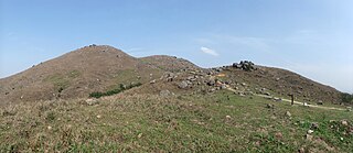
Chiu Keng Wan Shan 247Between Yau Tong and Tiu Keng Leng
Devil's Peak 222 Lei Yue Mun
Braemar Hill 200 North Point
Leighton Hill < 100 Causeway Bay and Happy Valley
Morrison Hill < 100 Wan Chai Named for John Robert Morrison, Chinese interpreter and British linguist and Colonial Secretary. The hill was levelled Praya at the time of the Praya East Reclamation Scheme in the 1920s, which used its constituent rock/earth to reclaim land from the harbour, extending the shoreline away from the area.
Mount Parish Causeway Bay and Happy Valley named for Commodore John E. Parish, commander of China Station 1873–1876

Volcanoes

Removed hills

See also

Related Research Articles

<span class="mw-page-title-main">Kowloon Peak</span> Mountain in Kowloon, Hong Kong

Kowloon Peak, also known as Fei Ngo Shan, is a 602 m (1,975 ft) tall mountain in the northeast corner of New Kowloon, Hong Kong, situated in Ma On Shan Country Park. It is the tallest mountain in Kowloon, and is crossed by both the Wilson Trail and the MacLehose Trail. On the lower slopes of Tung Yeung Shan about 1.1 miles to the north is the Gilwell Campsite, belonging to The Scout Association.

<span class="mw-page-title-main">Lantau Peak</span> Mountain on Lantau Island, Hong Kong

Lantau Peak or Fung Wong Shan is the second highest peak in Hong Kong and the highest point on Lantau Island, with a height of 934 metres (3,064 ft) above the Hong Kong Principal Datum, or around 933 metres (3,061 ft) above mean sea level.

<span class="mw-page-title-main">Kau Keng Shan</span> Hill in Tuen Mun, Hong Kong

Kau Keng Shan is a hill in Tuen Mun, the New Territories, Hong Kong and stands opposite from Castle Peak. Kau Keng Shan has a height of 507 metres (1,663 ft). During the Ming dynasty era (1368–1644), the area around the hill was used as a defence position against foreign forces, in particular the Portuguese, who had occupied Tuen Mun from 1514 to 1521.

<span class="mw-page-title-main">Temple Hill (Hong Kong)</span>

Temple Hill, also known as Tsz Wan Shan, is a hill between New Kowloon and the New Territories, Hong Kong. It peaks at 488 m. Beneath its south side is the residential area of Tsz Wan Shan and Buddhist temples. Sha Tin Pass runs between the hill and Unicorn Ridge. The summit of the hill is located within Sha Tin District.

<span class="mw-page-title-main">Sze Fong Shan</span>

Sze Fong Shan, located in Tai Po District of the New Territories, is the fourth highest peak in Hong Kong. With a height of 784 m (2,572 ft), it is northeast of Tai Mo Shan. The Eighth Stage of the MacLehose Trail passes near it.

<span class="mw-page-title-main">Lin Fa Shan</span>

Lin Fa Shan is the seventh highest mountain in Hong Kong. With a height of 766 m on Lantau Island, it is situated between Mui Wo and Sunset Peak.

<span class="mw-page-title-main">Yi Tung Shan</span>

Yi Tung Shan is the ninth highest mountain in Hong Kong. It is situated east of Sunset Peak on Lantau Island, and is 747 m in height. Stage 2 of The Lantau Trail runs along the north side of its peak.

<span class="mw-page-title-main">High West</span>

High West or Sai Ko Shan, is a mountain on Hong Kong Island with a height of 494 m (1,621 ft)

<span class="mw-page-title-main">Mount Butler</span>

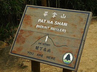
Mount Butler or Pat Na Shan is a 436 m high hill on Hong Kong Island, Hong Kong.

<span class="mw-page-title-main">Chiu Keng Wan Shan</span>

Chiu Keng Wan Shan is a hill that lies between the communities of Yau Tong and Tiu Keng Leng, Hong Kong.

Miu Ko Toi is a peak in Hong Kong. It is situated in New Territories and stands at a height of 779 metres (2,556 ft) above the sea level. It is one of the subpeaks of the tallest mountain Tai Mo Shan and the fifth highest summit in Hong Kong.

<span class="mw-page-title-main">Shek O Peak</span>

Shek O Peak or Ta Lan Tsing Teng Shan is a hill in southern Hong Kong. It is the tallest hill along the Dragon's Back trail.

<span class="mw-page-title-main">Ping Shan, Kowloon</span>

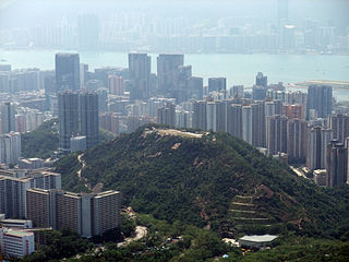
Ping Shan is a hill in Kwun Tong District, eastern Kowloon that lies between the communities of Ngau Chi Wan, Kowloon Bay and Jordan Valley, Hong Kong. Most of it was the Ping Shan Stone Quarry before redevelopedment into a new neighbourhood with numerous public housing estates and schools. Being unlabelled in most maps, it was often mistaken as part of the forementioned neighbourhoods and Ngau Tau Kok.

<span class="mw-page-title-main">Sai Wan Shan (Sai Kung)</span> Mountain of Hong Kong

Sai Wan Shan is a hill that lies within Sai Kung East Country Park, south of Tai Long Wan, on the Sai Kung Peninsula in Hong Kong. It has a height of 314 metres (1,030 ft) above sea level. The hill is reasonably easy for hikers and is a popular site for hiking in Hong Kong. A portion of MacLehose Trail Stage 2 is built along the ridge of this hill.

<span class="mw-page-title-main">Tin Wan Shan</span>

Tin Wan Shan is a hill in southern Hong Kong.

<span class="mw-page-title-main">Tiu Shau Ngam</span>

Tiu Shau Ngam, is a mountain in Hong Kong with a height of 589 metres (1,932 ft). It is located north of Ma On Shan, the tallest mountain in the region.

<span class="mw-page-title-main">Ling Kok Shan</span>

Ling Kok Shan is the second highest peak on Lamma Island in Hong Kong, after Mount Stenhouse, with a height of 250 metres (820 ft) above sea level.

<span class="mw-page-title-main">Shum Wan Shan</span> Peak in Hong Kong

Shum Wan Shan is a peak in Kwun Tong, Hong Kong. There is a water pumping station on Shum Wan Shan.

<span class="mw-page-title-main">Keung Shan</span> Mountain on Lantau Island, Hong Kong

Keung Shan is a peak in Hong Kong, on southwestern Lantau Island, with a height of 459 metres (1,506 ft) above sea level.

<span class="mw-page-title-main">Wa Mei Shan</span> Mountain in Lam Tsuen Country Park, Hong Kong

Wa Mei Shan is a mountain in northeastern Hong Kong on Sai Kung Peninsula. It is located within Tai Po District.

References

  1. 落探員. "Wildtrekking.net" 妙高台 [Miu Ko Toi] (in Chinese). Retrieved 29 September 2009.
  2. "GeoInfo Map.Map of Hong Kong provided by HKSARG". www.map.gov.hk. Retrieved 22 May 2020.
  3. Ovalles, César; Rechsteiner, Carl E. Jr., eds. (12 February 2015). Analytical Methods in Petroleum Upstream Applications. CRC Press. p. 752. ISBN   9781482230864.
  4. "Supervolcano discovery took years of digging - the Standard". Archived from the original on 7 January 2013. Retrieved 23 December 2012. [www.youtube.com/watch?v=vAtoOdZ-Pr0]
  5. "Current & Upcoming Events". Kadoorie Farm & Botanic Garden.
  6. http://geolsoc.org.hk/_newsletters/VOL%252014.2_Mar2008.pdf https://www.facebook.com/permalink.php?id=231062983601269&story_fbid=673694836004746&