In chronostratigraphy, a stage is a succession of rock strata laid down in a single age on the geologic timescale, which usually represents millions of years of deposition. A given stage of rock and the corresponding age of time will by convention have the same name, and the same boundaries.

Stratigraphy is a branch of geology concerned with the study of rock layers (strata) and layering (stratification). It is primarily used in the study of sedimentary and layered volcanic rocks. Stratigraphy has three related subfields: lithostratigraphy, biostratigraphy, and chronostratigraphy.
The lithology of a rock unit is a description of its physical characteristics visible at outcrop, in hand or core samples, or with low magnification microscopy. Physical characteristics include colour, texture, grain size, and composition. Lithology may refer to either a detailed description of these characteristics, or a summary of the gross physical character of a rock. Examples of lithologies in the second sense include sandstone, slate, basalt, or limestone.

An unconformity is a buried erosional or non-depositional surface separating two rock masses or strata of different ages, indicating that sediment deposition was not continuous. In general, the older layer was exposed to erosion for an interval of time before deposition of the younger layer, but the term is used to describe any break in the sedimentary geologic record. The significance of angular unconformity was shown by James Hutton, who found examples of Hutton's Unconformity at Jedburgh in 1787 and at Siccar Point in Berwickshire in 1788, both in Scotland.

In geology and related fields, a stratum is a layer of rock or sediment characterized by certain lithologic properties or attributes that distinguish it from adjacent layers from which it is separated by visible surfaces known as either bedding surfaces or bedding planes. Prior to the publication of the International Stratigraphic Guide, older publications have defined a stratum as either being either equivalent to a single bed or composed of a number of beds; as a layer greater than 1 cm in thickness and constituting a part of a bed; or a general term that includes both bed and lamina. Related terms are substrate and substratum (pl.substrata), a stratum underlying another stratum.
A geological formation, or simply formation, is a body of rock having a consistent set of physical characteristics (lithology) that distinguishes it from adjacent bodies of rock, and which occupies a particular position in the layers of rock exposed in a geographical region. It is the fundamental unit of lithostratigraphy, the study of strata or rock layers.
A stratigraphic unit is a volume of rock of identifiable origin and relative age range that is defined by the distinctive and dominant, easily mapped and recognizable petrographic, lithologic or paleontologic features (facies) that characterize it.
Sequence stratigraphy is a branch of geology, specifically a branch of stratigraphy, that attempts to discern and understand historic geology through time by subdividing and linking sedimentary deposits into unconformity bounded units on a variety of scales. The essence of the method is mapping of strata based on identification of surfaces which are assumed to represent time lines, thereby placing stratigraphy in chronostratigraphic framework allowing understanding of the evolution of the earth's surface in a particular region through time. Sequence stratigraphy is a useful alternative to a purely lithostratigraphic approach, which emphasizes solely based on the compositional similarity of the lithology of rock units rather than time significance. Unconformities are particularly important in understanding geologic history because they represent erosional surfaces where there is a clear gap in the record. Conversely within a sequence the geologic record should be relatively continuous and complete record that is genetically related.
Relative dating is the science of determining the relative order of past events, without necessarily determining their absolute age. In geology, rock or superficial deposits, fossils and lithologies can be used to correlate one stratigraphic column with another. Prior to the discovery of radiometric dating in the early 20th century, which provided a means of absolute dating, archaeologists and geologists used relative dating to determine ages of materials. Though relative dating can only determine the sequential order in which a series of events occurred, not when they occurred, it remains a useful technique. Relative dating by biostratigraphy is the preferred method in paleontology and is, in some respects, more accurate. The Law of Superposition, which states that older layers will be deeper in a site than more recent layers, was the summary outcome of 'relative dating' as observed in geology from the 17th century to the early 20th century.
Chronostratigraphy is the branch of stratigraphy that studies the ages of rock strata in relation to time.

In geology, a graded bed is a bed characterized by a systematic change in grain or clast size from bottom to top of the bed. Most commonly this takes the form of normal grading, with coarser sediments at the base, which grade upward into progressively finer ones. Such a bed is also described as fining upward. Normally graded beds generally represent depositional environments which decrease in transport energy as time passes, but these beds can also form during rapid depositional events. They are perhaps best represented in turbidite strata, where they indicate a sudden strong current that deposits heavy, coarse sediments first, with finer ones following as the current weakens. They can also form in terrestrial stream deposits.
In geology, a suite is a lithodemic unit consisting of two or more lithodemes of a single genetic class.

In geology, a bed is a layer of sediment, sedimentary rock, or volcanic rock "bounded above and below by more or less well-defined bedding surfaces". Specifically in sedimentology, a bed can be defined in one of two major ways. First, Campbell and Reineck and Singh use the term bed to refer to a thickness-independent layer comprising a coherent layer of sedimentary rock, sediment, or pyroclastic material bounded above and below by surfaces known as bedding planes. By this definition of bed, laminae are small beds that constitute the smallest (visible) layers of a hierarchical succession and often, but not always, internally comprise a bed.
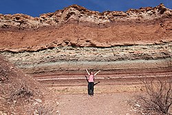
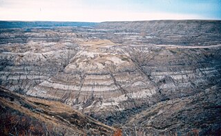
A stratigraphic section is a sequence of layers of rocks in the order they were deposited. It is based on the principle of original horizontality, which states that layers of sediment are originally deposited horizontally under the action of gravity.
In stratigraphy and geology, an eonothem is the totality of rock strata laid down in the stratigraphic record deposited during a certain eon of the continuous geologic timescale. The eonothem is not to be confused with the eon itself, which is a corresponding division of geologic time spanning a specific number of years, during which rocks were formed that are classified within the eonothem. Eonothems have the same names as their corresponding eons, which means during the history of the Earth only four eonothems were formed. Oldest to newest these are the Hadean, Archean, Proterozoic, and Phanerozoic. A rock stratum, fossil or feature present in the "upper Phanerozoic" eonothem would therefore have originated within the "later Phanerozoic" eon. In practice, the rock column is discontinuous:
Technically, a complete geologic record doesn't occur anywhere. For such a record to develop would require the area to have been receiving sedimentary deposits continually ever since the origin of the earth. Nowhere is such a situation known to exist. If it did exist, we could not effectively look at the strata because they would still be buried, and modern strata would continue to be deposited on top of them. The earth's surface has been far too dynamic to allow that to occur anywhere. No area has been in such a static condition throughout the earth's long history. Areas that have had sediment deposited on them at one time are later uplifted and eroded. In some places this has occurred many times. There is ample evidence to prove such a sequence of events.
Magnetostratigraphy is a geophysical correlation technique used to date sedimentary and volcanic sequences. The method works by collecting oriented samples at measured intervals throughout the section. The samples are analyzed to determine their characteristic remanent magnetization (ChRM), that is, the polarity of Earth's magnetic field at the time a stratum was deposited. This is possible because volcanic flows acquire a thermoremanent magnetization and sediments acquire a depositional remanent magnetization, both of which reflect the direction of the Earth's field at the time of formation. This technique is typically used to date sequences that generally lack fossils or interbedded igneous rock. It is particularly useful in high-resolution correlation of deep marine stratigraphy where it allowed the validation of the Vine–Matthews–Morley hypothesis related to the theory of plate tectonics.
The Buntsandstein or Bunter sandstone is a lithostratigraphic and allostratigraphic unit in the subsurface of large parts of west and central Europe. The Buntsandstein predominantly consists of sandstone layers of the Lower Triassic series and is one of three characteristic Triassic units, together with the Muschelkalk and Keuper that form the Germanic Trias Supergroup.
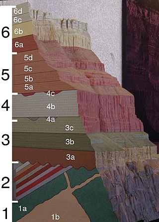
A stratigraphic column is a representation used in geology and its subfield of stratigraphy to describe the vertical location of rock units in a particular area. A typical stratigraphic column shows a sequence of sedimentary rocks, with the oldest rocks on the bottom and the youngest on top.
A geological contact is a boundary which separates one rock body from another. A contact can be formed during deposition, by the intrusion of magma, or through faulting or other deformation of rock beds that brings distinct rock bodies into contact.
Geological perspective correlation is a theory in geology describing geometrical regularities in the layering of sediments. Seventy percent of the Earth's surface are occupied by sedimentary basins – volumes consisted of sediments accumulated during million years, and alternated by long interruptions in sedimentation (hiatuses). The most noticeable feature of the rocks, which filled the basins, is layering (stratification). Stratigraphy is a part of Geology that investigates the phenomenon of layering. It describes the sequence of layers in the basin as consisted of stratigraphic units. Units are defined on the basis of their lithology and have no clear definition. Geological Perspective Correlation (GPC) is a theory that divided the geological cross-section in units according strong mathematical rule: all borders of layers in this unit obey the law of perspective geometry.
Sedimentation layers are mainly created in shallow waters of oceans, seas, and lakes. As new layers are deposited the old ones are sinking deeper due to the weight of accumulating sediments. The content of sedimentary layers, their order in the sequence, and geometrical characteristics keep records of the history of the Earth, of past climate, sea-level and environment. Most knowledge about the sedimentary basins came from exploration drilling when searching for oil and gas. The essential feature of this information is that each layer is penetrated by the wells in a number of scattered locations. This raises the problem of identifying each layer in all wells – the geological correlation problem The identification is based on comparison of 1) physical and mineralogical characteristics of the particular layer (lithostratigraphy), or 2) petrified remnants in this layer (biostratigraphy). The similarity of layers is decreasing as the distance between the cross-sections increases that leads to ambiguity of the correlation scheme that indicates which layers penetrated at different locations belong to the same body. To improve the results geologists take in consideration the spatial relations between layers, which restricted the number of acceptable correlations. The first restriction was formulated in XVII century: the sequence of layers is the same in any cross-section. The second one was discovered by Haites in 1963: In an undisturbed sequence of layers (strata) the thicknesses of any layer observed in two different locations obey the law of perspective geometry, i.e. the perspective ratio K = H1/H2 is the same for all layers in this succession. This theory attracted attention around the world., and particularly in Russia The theory is also a basis of the method of graphical correlation in biostratigraphy widely used in oil and coal industries.