North Miami Beach, Florida

Last updated

North Miami Beach, Florida
North Miami FL Fulford by the Sea Entrance04.jpg
North Miami Beach in April 2011
North Miami Beach, Florida (city seal).png
Nicknames: 
NMB
Motto: 
"Where People Care"
Miami-Dade County Florida Incorporated and Unincorporated areas North Miami Beach Highlighted.svg
Location in Miami-Dade County and the state of Florida
North Miami Beach.gif
U.S. Census Bureau map showing city limits
Coordinates: 25°55′49″N80°10′11″W / 25.93028°N 80.16972°W / 25.93028; -80.16972
Country Flag of the United States.svg  United States of America
State Flag of Florida.svg  Florida
County Flag of Miami-Dade County, Florida.png Miami-Dade
Settled (Fulford-By-The-Sea) 1881 [2]
Incorporated (Town of Fulford) 1926
Incorporated (City of Fulford) 1927
Incorporated (City of North Miami Beach) June 15, 1931
Government
  Type Commission-Manager
   Mayor Evan S. Piper [3]
   Vice Mayor Jay R. Chernoff
   Commissioners Daniela Jean,
Fortuna Smukler,
McKenzie Fleurimond,
Phyllis Smith, and
Michael Joseph
   City Manager Mario A. Diaz
   City Clerk Andrise Bernard
Area
[4]
  Total5.37 sq mi (13.91 km2)
  Land4.84 sq mi (12.55 km2)
  Water0.53 sq mi (1.36 km2)  6.43%
Elevation
10 ft (3 m)
Population
 (2020) [5]
  Total43,676
  Density9,016.52/sq mi (3,481.18/km2)
Time zone UTC-5 (EST)
  Summer (DST) UTC-4 (EDT)
ZIP Codes
33160, 33162, 33169, 33179, 33181
Area code(s) 305, 786, 645
FIPS code 12-49475 [6]
GNIS feature ID287838 [7]
Website www.citynmb.com

North Miami Beach (commonly referred to as NMB) is a city in Miami-Dade County, Florida, United States. The City of North Miami Beach is part of the Miami metropolitan area of South Florida. Originally named "Fulford-by-the-Sea" in 1926, after Captain William H. Fulford of the U.S. Coast Guard, the city was renamed "North Miami Beach" in 1931. The population was 43,676 at the 2020 US census. [5]

Contents

History

The first non-indigenous settlement was platted in 1881, and was called Fulford-By-The-Sea. [2]

In the 1920s, Carl G. Fisher built an all-wooden racetrack with stands for 12,000 spectators, known as the Fulford–Miami Speedway. This event, held on February 22, 1926, dubbed the Carl G. Fisher Cup Race, was a forerunner to the auto races at Sebring and Daytona. In September 1926, after just one race, the track was destroyed by the 1926 Miami Hurricane. [8]

The hurricane of 1926 essentially ended the South Florida real estate boom, and in an effort to alleviate their losses and the damage to the city, local residents came together as the Town of Fulford. In 1927, it was incorporated as the City of Fulford. [9]

Geography

The approximate coordinates for the City of North Miami Beach is located in northeastern Miami-Dade County at 25°55′49″N80°10′1″W / 25.93028°N 80.16694°W / 25.93028; -80.16694 . [10]

It is bordered to the southeast by the city of North Miami, to the southwest by unincorporated Golden Glades, to the west by the city of Miami Gardens, to the north by unincorporated Ojus, to the northeast by the city of Aventura, and to the east across the Intracoastal Waterway by the city of Sunny Isles Beach.

U.S. Route 1 (Biscayne Boulevard) runs through the east side of the city, leading south 11 miles (18 km) to downtown Miami and north 14 miles (23 km) to Fort Lauderdale. Interstate 95 runs along the northwest border of the city, with access from Exit 12.

According to the United States Census Bureau, the city has a total area of 5.37 square miles (13.9 km2). 4.4 square miles (11 km2) of it are land and 0.53 square miles (1.4 km2) of it (9.78%) are water. [4]

Although the North Miami Beach boundaries once stretched to the Atlantic Ocean, the city no longer has any beaches within its limits. They are now a short distance away, within the city of Sunny Isles Beach across the Intracoastal Waterway.

Climate

North Miami Beach has a tropical climate, similar to the climate found in much of the Caribbean. It is part of the only region in the 48 contiguous states that falls under that category. More specifically, it generally has a tropical rainforest climate (Köppen climate classification: Af), bordering a tropical monsoon climate (Köppen climate classification: Am). [11]

Climate data for North Miami Beach, Florida, 1991–2020 normals, extremes 2000present
MonthJanFebMarAprMayJunJulAugSepOctNovDecYear
Record high °F (°C)86
(30)
88
(31)
92
(33)
94
(34)
95
(35)
98
(37)
98
(37)
97
(36)
95
(35)
94
(34)
90
(32)
88
(31)
98
(37)
Mean maximum °F (°C)83.2
(28.4)
85.3
(29.6)
87.3
(30.7)
89.5
(31.9)
91.5
(33.1)
93.8
(34.3)
93.3
(34.1)
93.5
(34.2)
92.6
(33.7)
90.8
(32.7)
86.3
(30.2)
84.0
(28.9)
95.1
(35.1)
Mean daily maximum °F (°C)75.2
(24.0)
77.0
(25.0)
79.1
(26.2)
82.5
(28.1)
85.4
(29.7)
88.3
(31.3)
89.6
(32.0)
90.0
(32.2)
88.5
(31.4)
85.5
(29.7)
80.5
(26.9)
77.3
(25.2)
83.3
(28.5)
Daily mean °F (°C)67.1
(19.5)
69.0
(20.6)
71.3
(21.8)
75.2
(24.0)
78.5
(25.8)
81.5
(27.5)
82.7
(28.2)
83.1
(28.4)
82.0
(27.8)
79.0
(26.1)
73.4
(23.0)
69.7
(20.9)
76.0
(24.4)
Mean daily minimum °F (°C)59.0
(15.0)
61.0
(16.1)
63.6
(17.6)
67.9
(19.9)
71.7
(22.1)
74.7
(23.7)
75.8
(24.3)
76.2
(24.6)
75.4
(24.1)
72.5
(22.5)
66.3
(19.1)
62.2
(16.8)
68.8
(20.4)
Mean minimum °F (°C)43.7
(6.5)
47.1
(8.4)
51.3
(10.7)
58.8
(14.9)
64.3
(17.9)
70.7
(21.5)
71.6
(22.0)
72.5
(22.5)
72.1
(22.3)
63.6
(17.6)
54.3
(12.4)
49.7
(9.8)
41.3
(5.2)
Record low °F (°C)35
(2)
37
(3)
41
(5)
52
(11)
54
(12)
68
(20)
67
(19)
70
(21)
68
(20)
54
(12)
45
(7)
36
(2)
35
(2)
Average precipitation inches (mm)2.30
(58)
2.72
(69)
2.67
(68)
3.54
(90)
5.68
(144)
9.03
(229)
8.30
(211)
9.28
(236)
10.26
(261)
7.34
(186)
4.55
(116)
2.66
(68)
68.33
(1,736)
Average precipitation days (≥ 0.01 in)7.06.66.26.510.816.517.617.018.014.09.38.2137.7
Source: NOAA (mean maxima/minima 20062020) [12] [13]

Surrounding areas

Demographics

Historical population
CensusPop.Note
1940 871
1950 2,129144.4%
1960 21,405905.4%
1970 30,54442.7%
1980 36,55319.7%
1990 35,359−3.3%
2000 40,78615.3%
2010 41,5231.8%
2020 43,6765.2%
U.S. Decennial Census [14]

2010 and 2020 census

North Miami Beach racial composition
(Hispanics excluded from racial categories)
(NH = Non-Hispanic)
RacePop 2010 [15] Pop 2020 [16] % 2010% 2020
White (NH)7,6307,62118.38%17.45%
Black or African American (NH)16,25114,46439.14%33.12%
Native American or Alaska Native (NH)58460.14%0.11%
Asian (NH)1,3731,4913.31%3.41%
Pacific Islander or Native Hawaiian (NH)1640.04%0.01%
Some other race (NH)1723660.41%0.84%
Two or more races/Multiracial (NH)8101,1611.95%2.66%
Hispanic or Latino (any race)15,21318,52336.64%42.41%
Total41,52343,676

As of the 2020 U.S. census, there were 43,676 people, 13,617 households, and 9,548 families residing in the city. [17]

As of the 2010 U.S. census, there were 41,523 people, 13,681 households, and 9,462 families residing in the city. [18]

2000 census

As of 2000, 37.6% had children under the age of 18 living with them. 44.3% were married couples living together, 19.5% had a female householder with no husband present, and 29.9% were non-families. 23.9% of all households were made up of individuals, and 8.6% had someone living alone who was 65 years of age or older. The average household size was 2.89 and the average family size was 3.44.

As of the census of 2000, there were 40,786 people, 13,987 households, and 9,804 families residing in the city. The population density was 3,174.9 inhabitants per square kilometre (8,223/sq mi). There were 15,350 housing units at an average density of 1,194.9 per square kilometre (3,095/sq mi). The racial makeup of the city was 46.68% White (24.8% were Non-Hispanic White), [19] 38.97% African American, 0.29% Native American, 4.04% Asian, 0.07% Pacific Islander, 4.61% from other races, and 5.34% from two or more races. Hispanic or Latino of any race were 30.02% of the population.

As of 2000, there were 13,987 households out of which 37.6% had children under the age of 18 living with them, 44.3% were married couples living together, 19.5% had a female householder with no husband present, and 29.9% were non-families. 23.9% of all households were made up of individuals and 8.6% had someone living alone who was 65 years of age or older. The average household size was 2.89 and the average family size was 3.44.

In 2000, the city the population was spread out with 27.3% under the age of 18, 9.4% from 18 to 24, 30.9% from 25 to 44, 21.1% from 45 to 64, and 11.3% who were 65 years of age or older. The median age was 34 years. For every 100 females there were 91.6 males. For every 100 females age 18 and over, there were 86.3 males.

In 2000, the median income for a household in the city was $31,377, and the median income for a family was $35,047. Males had a median income of $26,278 versus $22,110 for females. The per capita income for the city was $14,699. About 18.4% of families and 20.5% of the population were below the poverty line, including 25.1% of those under age 18 and 18.2% of those age 65 or over.

As of 2000, English was the first language for 38.50% of all residents, while Spanish accounted for 31.97%, French Creole 19.32%, French 2.33%, Chinese 1.55%, Portuguese 1.20%, Hebrew 0.87%, Russian 0.65%, Yiddish 0.56%, and Italian 0.52% of the population. [20]

As of 2000, North Miami Beach had the fourth highest percentage of Haitian residents in the US, with 19.9% of the US populace. [21] It had the forty-seventh highest percentage of Colombian residents in the US, at 2.83% of the city's population, [22] and the sixty-seventh highest percentage of Cuban residents in the US, at 4.92% of the city's population. [23] It also had the sixtieth most Dominicans in the US, at 2.39% (tied with Virginia Gardens,) [24] while it had the twenty-ninth highest percentage of Bahamians (tied with Munford, Alabama,) at 1.1% of all residents. [25] North Miami Beach's Jamaican community had the twenty-first highest percentage of residents, which was at 5.5% of all residents. [21] It's also home to the twenty-eighth highest percentage of Peruvian residents in the US, at 1.8% of the population (tied with Richmond West.) [26]

North Miami Beach has a middle class Haitian American, Chinese American, and Jewish American community who were born in the U.S. or abroad.[ citation needed ]

Chinatown

Despite Asians making up only 3.41% of North Miami Beach's population as of 2020, the city's main commercial artery along NE 167th street converging into North Miami Beach Boulevard and then becoming 163rd street, has taken the unofficial name of "Chinatown" due to the large concentration of Asian owned and operated businesses in the area. The area has been referred to unofficially as "Chinatown" since the early 1990s by both locals and North Miami Beach city officials. As of late, even Miami-Dade County officials have begun to reference the area as Chinatown. Local guides and Miami websites have called 163rd street Miami's unofficial Chinatown.

Attractions

Map of North Miami Beach's neighborhoods Nmbhoods.jpg
Map of North Miami Beach's neighborhoods

Attractions in the vicinity of North Miami Beach include a line of popular Atlantic Ocean beaches, Ancient Spanish Monastery, Oleta River State Park, Greynolds Park, East Greynolds Park, Fulford-by-the-Sea Monument, and Aventura Mall.

North Miami Beach's has a historic 12th century medieval Spanish monastery, the St. Bernard de Clairvaux Church. This stone building around a patio, the cloisters of the Monastery of St. Bernard de Clairvaux, was built in Sacramenia, Segovia, Spain in the 12th century. It was purchased by William Randolph Hearst in the 1920s, dismantled and shipped to the United States, and reassembled after Hearst's death in North Miami Beach in the 1950s. It is a tourism attraction and a popular spot for weddings.

Parks and recreation

In 1966, a major accomplishment was the completion of the tennis complex and two community centers, Victory Park and Uleta Community Center.

In 1968, the Washington Park Community Center [27] was built, and the Allen Park Youth Center [28] was completed in 1973.

North Miami Beach expanded its parks in the 1980s as a result of the city commission making strides to benefit the community.

The city now has the Judge Arthur I. Snyder Tennis Center. It includes twelve lighted clay Hydrogrid tennis courts, six lighted lay-kold hard tennis courts, four racquetball courts, and two paddleball courts. The center also has a clubhouse and pro-shop, a picnic area, and lounge and shower facilities. [29]

Government and infrastructure

North Miami Beach is governed by a commission-manager system [30] in the form of a Mayor, Commission, and a professional City Manager. In this type of a government, commission members are the leaders and policy makers in the community. This form of government was implemented in 1958, after a new charter was voted on. [9]

The mayor is elected citywide and serves up to two consecutive two-year terms. [31]

There is an elected mayor and six-member city commission, with the city manager, city clerk, and city attorney being appointed positions that are responsible for implementing the policies of the city commission. [31]

The Federal Bureau of Investigation (FBI) Miami field office was previously in North Miami Beach. It moved to Miramar on December 8, 2014. [32]

In 1993, in an effort to promote neighborhood stability throughout the city, North Miami Beach built a state-of-the-art police station and redeveloped infrastructure in the Government Center neighborhood.

The bond program Proud Neighborhoods took place in September 2000 and had 67 different projects. This allowed for the improvement of streets, sidewalks, lighting and landscaping in every neighborhood of the city. It took five years but it brought substantial improvements.

In the wake of the nearby Surfside condominium building collapse on June 24, the city stepped up building inspections and enforcement, and on July 2, condemned a 10-story condominium, Crestview Towers. [33]

Education

Primary and secondary schools

Miami-Dade County Public Schools serves North Miami Beach.

Public elementary schools

Public middle schools

Public high schools

Prior to the opening of North Miami Beach High and Krop, students from North Miami Beach were assigned to Miami Beach High School and Miami Norland High School. [34]

Private schools

Colleges and universities

Public libraries

North Miami Beach Public Library (NMB Library), also referred to as the Lafe Allen Public Library, is a 23,000 square foot facility located at 1601 NE 164th Street in North Miami Beach, Florida. The library's collection currently contains over 60,000 items, including both fiction and non-fiction materials, DVDs, audio books, compact discs, newspapers, magazines, and foreign language materials. Digital services include access to e-materials and reference resources, such as Florida Electronic Library, Newsbank, Reference USA, World Book, NoveList Plus, and more. [35]

In 1959, the North Miami Beach Library was initially opened inside of a storefront on NE 163rd Street as a branch of the Miami-Dade Public Library System (then known as the City of Miami Library system). This location was relocated and expanded to two storefronts at the corner of NE 19th Avenue and NE 169th Street the following year. [36] In 1961, however, the city ended its attachment with the City of Miami Library system and became an independent library. During this time, the library was merely a staff of two. The staff had a minor budget of 25,000 to build the collection for the library. After residents of the City of North Miami Beach voted to build a permanent location for the library in 1964, a new building was constructed on 164th Street and opened in 1965. Renovations to this facility in 1981 and 1994 grew the branch from its original 10,000 square feet to make room for the library's expanding collection. The last reservation took place in 1994 and granted the facility its current dimensions at over 23,000 square feet.

The NMB Library offers a variety of services to the residents of North Miami Beach, such as access to study and meeting rooms, employment resources, early literacy programs, voter registration forms, citizenship materials, and passport assistance. Computers, printers, copiers, scanners, and fax machine services are also available. The library's dedicated teen area, known as the Discovery District, is a space specifically designed to provide library patrons aged 13–19 with a place to read, study, or work on school projects. [37] Access to computers, 3D printers, virtual reality, and zSpace for educational and recreational purposes is also provided.

Notable people

Related Research Articles

<span class="mw-page-title-main">Cooper City, Florida</span> City in Florida

Cooper City is a city in Broward County, Florida, United States. The city is named for Morris Cooper, who founded the community in 1959. It's part of the Miami metropolitan area of South Florida. The city's population was 34,401 at the 2020 census.

Miami Gardens was a census-designated place (CDP) in Broward County, Florida, United States. The population was 2,706 at the 2000 census.

<span class="mw-page-title-main">Miramar, Florida</span> City in Florida, United States

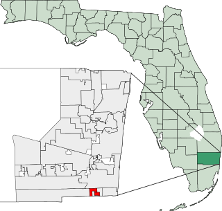
Miramar is a city in southern Broward County, Florida, United States. It is a key suburb of the Miami metropolitan area, which was home to 6.14 million people in 2020. As of the 2020 census, the population was 134,721, making it the second-largest city in Broward County, the fourth-largest city in the Miami metro area, and the 11th-largest city in Florida.

<span class="mw-page-title-main">North Lauderdale, Florida</span> City in Florida

North Lauderdale is a city in Broward County, Florida, United States. It is a principal city of the Miami metropolitan area. As of the 2020 census, the city's population was 44,794.

<span class="mw-page-title-main">Pembroke Park, Florida</span> Town in the state of Florida, United States

Pembroke Park is a town in Broward County, Florida, United States. The town took its name from its location along Pembroke Road. It is part of the South Florida metropolitan area. Almost one-half of its residents live in mobile homes. As of the 2020 census, the population was 6,260.

<span class="mw-page-title-main">Pembroke Pines, Florida</span> City in Broward County, Florida, United States

Pembroke Pines is a city in southern Broward County, Florida, United States. The city is located 22 miles (35 km) north of Miami. It is a suburb of and the fourth-most populous city in the Miami metropolitan area. The population of Pembroke Pines was 171,178 at the 2020 census.

<span class="mw-page-title-main">Tamarac, Florida</span> City in Florida, United States

Tamarac is a city in Broward County, Florida, United States. It is part of the Miami metropolitan area. At the 2020 census, the city had a population of 71,897.

<span class="mw-page-title-main">Aventura, Florida</span> City in Florida

Aventura is a planned suburban city in northeastern Miami-Dade County, Florida, United States, 15 miles (24 km) north of Miami and part of the Miami metropolitan area of South Florida. The city is especially known for Aventura Mall, the third largest mall in the United States by total square feet of retail space and the largest mall in Florida.

<span class="mw-page-title-main">Bunche Park, Florida</span> Neighborhood of Miami Gardens in Miami-Dade, Florida, United States

Bunche Park is a neighborhood in Miami Gardens, Florida, United States. It was formerly a census-designated place.

<span class="mw-page-title-main">Carol City, Florida</span> Neighborhood of Miami Gardens in Miami-Dade, Florida, United States

Carol City is a neighborhood in Miami Gardens, Florida, United States. The population was 61,233 at the 2010 census. It was formerly a census-designated place.

<span class="mw-page-title-main">Golden Beach, Florida</span> Town in Florida

Golden Beach is a town in Miami-Dade County, Florida, United States, between the Intracoastal Waterway and Atlantic Ocean. The town is part of the Miami metropolitan area of South Florida. As of the 2020 US census, the town had a population of 961.

<span class="mw-page-title-main">Golden Glades, Florida</span> Census-designated place in Florida

Golden Glades is a census-designated place (CDP) in Miami-Dade County, Florida, United States. It is part of the Miami metropolitan area of South Florida. The population was 32,499 at the 2020 US census.

<span class="mw-page-title-main">Goulds, Florida</span> Census-designated place in Florida

Goulds is an unincorporated community and census-designated place (CDP) in Miami-Dade County, Florida, United States. The area was originally populated as the result of a stop on the Florida East Coast Railroad. The railroad depot was located near the current Southwest 224th Street. The community was named after its operator, Lyman Gould, who cut trees for railroad ties. It is part of the Miami metropolitan area of South Florida. As of the 2020 US census, the population stood at 11,446, up from 10,103 in 2010 US census.

<span class="mw-page-title-main">Ives Estates, Florida</span> Census-designated place in Florida

Ives Estates is a census-designated place (CDP) in Miami-Dade County, Florida. It is part of the Miami metropolitan area of South Florida. The population was 25,005 at the 2020 census, up from 19,525 in 2010.

<span class="mw-page-title-main">Naranja, Florida</span> Census-designated place in Florida

Naranja is an unincorporated community and census-designated place (CDP) in Miami-Dade County, Florida, United States. Many orange groves were once located in this area, so the community name came from the Spanish word for orange, naranja, though the pronunciation among the local residents is "Na-Ran-Jah". Naranja was also a stop for the Florida East Coast Railroad that once ran through this area. It is part of the Miami metropolitan area of South Florida. The population was 13,509 at the 2020 census, up from 8,303 in 2010.

<span class="mw-page-title-main">North Miami, Florida</span> City in Florida

North Miami is a suburban city located in northeast Miami-Dade County, Florida, United States, about 10 miles (16 km) north of Miami. The city lies on Biscayne Bay and hosts the Biscayne Bay Campus of Florida International University.. Originally the "Town of Arch Creek", the area was incorporated as the "Town of Miami Shores", which was renamed the "Town of North Miami" in 1931. It was reincorporated as a city in 1953. The city is part of the Miami metropolitan area of South Florida.

<span class="mw-page-title-main">Ojus, Florida</span> Census-designated place in Florida

Ojus is a census-designated place and formerly incorporated town in Miami-Dade County, Florida, United States. It is part of the Miami metropolitan area of South Florida. The population was 19,673 at the 2020 census, up from 18,036 in 2010.

<span class="mw-page-title-main">Sunny Isles Beach, Florida</span> City in Florida

Sunny Isles Beach is a city located on a barrier island in northeast Miami-Dade County, Florida, United States. The city is part of the Miami metropolitan area of South Florida, and is bounded by the Atlantic Ocean on the east and the Intracoastal Waterway on the west. As of the 2020 census, it had a population of 22,342.

<span class="mw-page-title-main">Lantana, Florida</span> Town in the state of Florida, United States

Lantana is a town in Palm Beach County, Florida, United States. It is 37 miles (60 km) north from Fort Lauderdale and 62 miles (100 km) north of Miami. This town is part of the Miami metropolitan area of South Florida. The population was 11,504 at the 2020 United States Census.

<span class="mw-page-title-main">West Park, Florida</span> City in Florida

West Park, officially the City of West Park, is a municipality in Broward County, Florida, United States. It was created on March 1, 2005. West Park is part of Miami metropolitan area of South Florida. It is located in the southeastern part of the county and consists of the neighborhoods of Carver Ranches, Lake Forest, Miami Gardens, and Utopia. A large portion of the city lies west of the town of Pembroke Park, so the new city was called "West Park". The city has a population of 15,130 as of the 2020 census.

References

  1. "Article I. Incorporation and Boundaries". City of North Miami Beach. Archived from the original on November 18, 2012. Retrieved December 9, 2012.
  2. 1 2 "From Farms and Fields to the Future:: The Incredible History of North Miami Beach". Amazon .
  3. "Mayor Evan S. Piper". citynmb.com. Retrieved April 3, 2024.
  4. 1 2 "2022 U.S. Gazetteer Files: Florida". United States Census Bureau. Retrieved December 27, 2022.
  5. 1 2 "P1. Race – North Miami Beach city, Florida: 2020 DEC Redistricting Data (PL 94-171)". U.S. Census Bureau. Retrieved December 27, 2022.
  6. "U.S. Census website". United States Census Bureau . Retrieved January 31, 2008.
  7. "US Board on Geographic Names". United States Geological Survey. October 25, 2007. Retrieved January 31, 2008.
  8. "Our History - City of North Miami Beach, Florida". Citynmb.com. Archived from the original on May 17, 2013. Retrieved July 20, 2013.
  9. 1 2 "Our History – City of North Miami Beach, Florida". www.citynmb.com. Retrieved April 18, 2016.
  10. "US Gazetteer files: 2010, 2000, and 1990". United States Census Bureau. February 12, 2011. Retrieved April 23, 2011.
  11. "Köppen Climate Classification Map: South Florida=Am/Aw=tropical wet & dry". Archived from the original on July 6, 2011.
  12. "NOWData - NOAA Online Weather Data". National Oceanic and Atmospheric Administration . Retrieved May 14, 2021.
  13. "Summary of Monthly Normals 19912020". National Oceanic and Atmospheric Administration . Retrieved May 14, 2021.
  14. "Decennial Census of Population and Housing by Decades". US Census Bureau.
  15. "P2 HISPANIC OR LATINO, AND NOT HISPANIC OR LATINO BY RACE - 2010: DEC Redistricting Data (PL 94-171) - North Miami Beach city, Florida". United States Census Bureau .
  16. "P2 HISPANIC OR LATINO, AND NOT HISPANIC OR LATINO BY RACE - 2020: DEC Redistricting Data (PL 94-171) - North Miami Beach city, Florida". United States Census Bureau .
  17. "S1101 HOUSEHOLDS AND FAMILIES - 2020: North Miami Beach city, Florida". United States Census Bureau .
  18. "S1101 HOUSEHOLDS AND FAMILIES - 2010: North Miami Beach city, Florida". United States Census Bureau .
  19. "Demographics of North Miami Beach, FL". MuniNetGuide.com. Retrieved October 30, 2007.
  20. "MLA Data Center Results of North Miami Beach, FL". Modern Language Association . Retrieved October 28, 2007.
  21. 1 2 "Ancestry Map of Haitian Communities". Epodunk.com. Retrieved October 28, 2007.
  22. "Ancestry Map of Colombian Communities". Epodunk.com. Retrieved October 28, 2007.
  23. "Ancestry Map of Cuban Communities". Epodunk.com. Retrieved October 28, 2007.
  24. "Ancestry Map of Dominican Communities". Epodunk.com. Retrieved October 28, 2007.
  25. "Ancestry Map of Bahamian Communities". Epodunk.com. Retrieved October 28, 2007.
  26. "Ancestry Map of Peruvian Communities". Epodunk.com. Retrieved October 28, 2007.
  27. Washington Park Community Center
  28. Allen Park Youth Center
  29. "Judge Arthur I. Snyder Tennis Center." City of North Miami Beach. Retrieved on March 12, 2010.
  30. "GOVERNMENT | North Miami Beach, FL". www.citynmb.com. Retrieved March 9, 2019.
  31. 1 2 "City of North Miami – Government". www.northmiamifl.gov. Retrieved April 18, 2016.
  32. "FBI Miami Division Moves to New Location." Federal Bureau of Investigation. December 8, 2014. Retrieved on June 9, 2015.
  33. Cetoute, Devoun; Wile, Rob (July 2, 2021). "North Miami Beach orders 10-story condo evacuated after report declares it unsafe". Miami Herald. Retrieved July 3, 2021.
  34. Bramson, Seth. From Farms and Fields to the Future: The Incredible History of North Miami Beach. Arcadia Publishing, June 1, 2012. ISBN   1614236410, 9781614236412. Google Books PT 125. "[...] and then on to North Miami Beach Senior High,[...] or Dr. Michael Krop Senior High,[...] to complete their secondary educations. (Prior to the opening of NMB and Krop, North Miami Beach's high school-age students went to North Miami or Norland High Schools.)"
  35. "About Us". North Miami Beach Public Library. Retrieved February 28, 2024.
  36. "The History of NMB Library". City of North Miami Beach. Retrieved April 19, 2020.
  37. "Discovery District". North Miami Beach Public Library. Retrieved February 28, 2024.