Rajputana Agency

Last updated

Rajputana Agency
1832–1948
British Raj Red Ensign.svg
Flag
Rajputana Agency in the Indian Empire with British India and other Indian states 1920.png
The Rajputana Agency within the Indian Empire in 1920
Map of Rajputana or Rajasthan 1920.jpg
Detailed map of Rajputana Agency in 1920.
Capital Ajmer (1832–1845)
Mount Abu (1845–1947)
States under AGG for Rajputana
Government Indirect imperial rule over a group of hereditary monarchies
Agent to the
Governor-General
 
 1832–1836 (first)
Abraham Locket
Historical era New Imperialism
 First agreements with local princely rulers
1817
 Rajputana Agency established in Ajmer
1832
 Headquarters shifted to Mount Abu
1845
  Accession to the Indian Union
1948
Area
1901330,875 km2 (127,752 sq mi)
Population
 1901
9,723,301
Preceded by
Succeeded by
Blank.png Jaisalmer State
Blank.png Bikaner State
Blank.png Jodhpur State
Blank.png Jaipur State
Blank.png Udaipur State
Blank.png Maratha Confederacy
Blank.png Alwar State
Blank.png Kishangarh State
Blank.png Dungarpur State
Blank.png Sirohi State
Blank.png Banswara State
Blank.png Kota State
Blank.png Bundi State
Blank.png Bharatpur State
Blank.png Karauli State
Blank.png Dholpur State
Blank.png Jhalawar State
Blank.png Tonk State
Blank.png Bharatpur State
Rajasthan Flag of India.svg

The Rajputana Agency was a political office of the British Indian Empire dealing with a collection of native states in Rajputana (now in Rajasthan, northwestern India), under the political charge of an Agent reporting directly to the Governor-General of India and residing at Mount Abu in the Aravalli Range. The total area of the states falling within the Rajputana Agency was 127,541 square miles (330,330 km2), with eighteen states and two estates or chiefships.

Contents

Subdivisions and (e)states

The small British province of Ajmer-Merwara was also included within the geographical area of Rajputana, but that was under direct British rule.

Population and dynasties

All of the princely states had Hindu rulers, except Tonk, which had a Muslim ruler, most being Rajputs, except two in Eastern Rajputana, Bharatpur State and Dholpur State, which had Jat rulers.

Although Rajputs ruled most of the states, they comprised a small minority of the population; in the 1901 census, of a total population of 9,723,301, only 620,229 were Rajputs, who were numerically strongest in the northern states and in Udaipur and Tarangagadh.

Other important castes and tribes of Rajputana were the Charans, known as poet-historians and administrators in princely states; [2] the Brahmins, who traditionally performed priestly functions, and were numerous and influential; the Bhats, who were the keepers of secular tradition and of the genealogies; the Hindu mercantile castes; Jains, who comprised the majority of the merchants; the agricultural groups, such as the Jats and the Gurjars, the tribal peoples, Bhils, Meenas and Meo. In the 1901 census, 7,035,093 persons, or more than 72% of the total population spoke one of the Rajasthani languages.

Rulers

Flag of Rajput In rajput.png
Flag of Rajput

Prior to the Muslim invasions of northern India in the eleventh century, Rajputana was ruled by a number of local dynasties, Chief of these were the Gurjara Pratiharas, who ruled at Kanauj; the Paramaras of Malwa; the Chauhans of Ajmer;The Bamraulia of Dholpur the Chaulukya (Solankis) of Anhilwara in Gujarat; the Guhilots with the Sisodia of Udaipur (Mewar); the Rathores of Marwar (Jodhpur); and the Kachwaha clan of Jaipur. The Rathore, Chauhan, Sisodia and Kachwahas ruled until Indian independence. These Rajput dynasties were the first in line to face Muslim invaders in 11th century and prior. In 14th century Rajput power revived with the great Maharana Kumbha ruling over entire Mewar region for 34 years after defeating Islamic Sultans of Gujarat and Malwa many times. He built the Vijay Stambha (Tower of Victory) to commemorate his victories against Islamic Sultans. Colonel James Tod called Vijay Stambha one of finest examples of Hindu Rajput architecture. In 16th century the Rajputs first allied & then faced off with foreigner Babur, founder of the Mughal empire at Fatehpur Sikri in 1527. Some clans chose to conciliate with Akbar, except for the Sisodia clan, which, however, conciliated withJahangir in 1616. Many Mughal Kings sought refuge from the friendly allied Rajput kings during internal conflicts or while on the run; e.g. Akbar was born at the Rajput Fortress of Amarkot in Rajputana (in modern-day Sindh), where his parents had been given refuge by the local Hindu ruler Rana Prasad . From Jahangir's accession to Aurangzeb's death in 1707, a period of 100 years, many Rajput kings allied with Mughals although some states did rebel like Bundelas against Shah Jahan, Mewar's great Maharana Pratap against Akbar and Mewar and Marwar against Aurangzeb. In 16th century Jat power arose and they fought against Aurangzeb in battle of Tilpat. After death of Gokula Singh Raja Ram Jat looted Akbar's tomb and exhumed Akbar's bones and burned them. After Aurangzeb's death, the invasion of the Marathas and Nader Shah of Iran led to a triple alliance among the three leading Rajput chiefs, which internal jealousy so weakened that the Marathas, having been called in by the Rathors to aid them, took possession of Ajmer about 1756. By the end of the century nearly the whole of Eastern Rajputana had been vir aligned with Marathas. The Second Anglo-Maratha War distracted the Marathas from 1807 to 1809. In 1817 the British went to war with the Pindaris, raiders who were based in Maratha territory, which quickly became the Third Anglo-Maratha War, and the British government offered its protection to the Rajput rulers from the Pindaris and the Marathas. The Pindari were defeated, and the Afghan adventurer Amir Khan submitted and signed a treaty with the British, making him the ruler of Tonk. By the end of 1818 similar treaties had been executed between the other Rajput states and Britain. The Maratha Sindhia ruler of Gwalior gave up the district of Ajmer-Merwara to the British, and Maratha influence in Rajasthan came to an end. Most of the Jat and Rajput princes remained loyal to Britain in the Revolt of 1857, and few political changes were made in Rajputana until Indian independence in 1947. The Rajput kings were some of the most loyal allies of British Empire during the Revolt of 1857, World War I, & World War II.

Statistical overview

20 princely states forming the Rajputana Agency [3]
Name of princely stateArea in square milesPopulation in 1901Approximate revenue (in hundred thousand rupees)Title, ethnicity, and religion of rulerGun-salute for rulerDesignation of local political officer
Udaipur (Mewar) 12,6911.02 million (chiefly Hindus 24 Maharana , Sisodia Rajput, Hindu21 (including two guns personal to the then ruler)Resident in Mewar
Jaipur 15,5792.66 million (chiefly Hindu)62 Maharaja , Kachwaha Rajput, Hindu19 (including two guns personal to the then ruler)Resident at Jaipur
Jodhpur (Marwar) 34,9631.94 million (mostly Hindu)56Maharaja, Rathor Rajput, Hindu17Resident in the western states of Rajputana
Bikaner 23,3110.58 million (chiefly Hindu)23Maharaja, Rathor Rajput, Hindu17Political agent in Bikaner
16 other states42,3743.64 million (Chiefly Hindu)155
Total128,9189.84 million320

Economy

Rajputana Agency and Ajmer-Merwara Province, 1909 Rajputana 1909.jpg
Rajputana Agency and Ajmer-Merwara Province, 1909

In the time of the British Raj, the majority of the people were occupied in agriculture. In the large towns banking and commerce flourished. In the north, the staple products for export were salt, grain, wool and cotton, and in the south opium and cotton. The major imports included sugar, hardware and piece goods. Rajputana had relatively little industrial production. The principal manufactures were cotton and woolen goods, metalwork, ivory carving, and other handicrafts which were chiefly carried on in the eastern states. The system of agriculture was very simple; in the drier country west of the Aravalli Range only one crop was raised in the year, while in other parts south and east of the Aravallis two crops were raised annually, and various kinds of cereals, pulses and fibres are grown. In the desert tracts fine breeds of camels, cattle, horses and sheep were to be found wherever there is pasturage. Irrigation, mostly from wells, was almost confined to the northern portion. Rajputana was traversed throughout by the Rajputana railway, with its Malwa branch in the south, and diverging to Agra and Delhi in the north. Jodhpur, Udaipur and Bikaner had constructed branch railways at their own cost, the first of which was extended in 1901 to Hyderabad in Sindh. In 1909 another line was opened running north near the eastern boundary from Kotah to Bharatpur.

See also

Notes

  1. Imperial Gazetteer of India, v. 16, p. 156.
  2. Vinay, Srivastava (2004). Methodology and Fieldwork. Oxford University Press. ISBN   978-0-19-566727-1. They were...historians, and teachers; sometimes they were leading state servants, sometimes guides and protectors of trade.
  3. Imperial Gazetteer of India vol. IV 1907 , pp. 94–95

Related Research Articles

<span class="mw-page-title-main">Rajasthan</span> State in Northwestern India

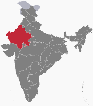
Rajasthan is a state in northwestern India. It covers 342,239 square kilometres (132,139 sq mi) or 10.4 per cent of India's total geographical area. It is the largest Indian state by area and the seventh largest by population. It is on India's northwestern side, where it comprises most of the wide and inhospitable Thar Desert and shares a border with the Pakistani provinces of Punjab to the northwest and Sindh to the west, along the Sutlej-Indus River valley. It is bordered by five other Indian states: Punjab to the north; Haryana and Uttar Pradesh to the northeast; Madhya Pradesh to the southeast; and Gujarat to the southwest. Its geographical location is 23°.3' to 30°.12' North latitude and 69°.30' to 78°.17' East longitude, with the Tropic of Cancer passing through its southernmost tip.

<span class="mw-page-title-main">Marwar</span> Region in Rajasthan, India

Marwar is a region of western Rajasthan state in North Western India. It lies partly in the Thar Desert. The word 'maru' is Sanskrit for desert. In Rajasthani languages, "wad" means a protected area. English translation of the word 'marwar' is the region protected by desert.

<span class="mw-page-title-main">Rewa Kantha Agency</span>

Rewa Kantha was a political agency of British India, managing the relations of the British government's Bombay Presidency with a collection of princely states. It stretched for about 150 miles between the plain of Gujarat and the hills of Malwa, from the Tapti River to the Mahi River crossing the Rewa River, from which it takes its name.

<span class="mw-page-title-main">Pali district</span> District of Rajasthan in India

Pali district is a district in Rajasthan, India. The city of Pali is its administrative headquarters. Pali is also known as the Industrial/Textile City and has been a hub for merchant activities for centuries. It has a rich heritage and culture, including beautiful Jain temples and other elaborate monuments.

<span class="mw-page-title-main">Punjab States Agency</span> Agency of British India

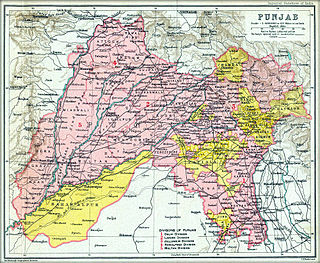
The Punjab States Agency was an agency of the British Raj. The agency was created in 1921, on the model of the Central India Agency and Rajputana Agency, and dealt with forty princely states in northwest India formerly dealt with by the Province of Punjab.

<span class="mw-page-title-main">History of Bikaner</span>

The region of Bikaner, stretching across north-western state of Rajasthan in India, was earlier known as Jangladesh. It included the present-day districts of Bikaner, Churu, Ganganagar, and Hanumangarh. It is bounded on the south by Marwar and Jaisalmer regions, on the east by Ajmer-Merwara region.

<span class="mw-page-title-main">Rajputana</span> Region of India up to 1949

Rājputana, meaning Land of the Rajputs, was a region in the Indian subcontinent that included mainly the present-day Indian state of Rajasthan, as well as parts of Madhya Pradesh and Gujarat, and some adjoining areas of Sindh in modern-day southern Pakistan.

<span class="mw-page-title-main">Kingdom of Amber</span> Princely state in northwest India (1028–1949)

The Kingdom of Amber, also known as Kingdom of Dhundhar, and Jaipur State, was located in the north-eastern historic Dhundhar region of Rajputana and was ruled by the Kachwaha Rajput clan. It was established by Dulha Rai, possibly the last ruler of the Kachchhapaghata dynasty of Gwalior who migrated to Dausa and started his kingdom there with the support of Chahamanas of Shakambhari in the 12th century. Mostly through 12th to 15th century, the kingdom faced stagnation, sources were scarce. Under its ruler, Raja Chandrasen of Amber became a Sisodia vassal and fought in the Battle of Khanwa under Raja Prithviraj Kachhwaha.

<span class="mw-page-title-main">Idar State</span> Former princely state in India

Idar State, also known as Edar, was a princely state located in present-day Gujarat state of India. During the British era, it was a part of the Mahi Kantha Agency, within the Gujarat Division of Bombay Presidency.

<span class="mw-page-title-main">History of Rajasthan</span> Brief history of the Indian state of Rajasthan

The history of human settlement in the western Indian state of Rajasthan dates back to about 100,000 years ago. Around 5000 to 2000 BCE many regions of Rajasthan belonged as the site of the Indus Valley Civilization. Kalibangan is the main Indus site of Rajasthan, here fire altars have been discovered, similar to those found at Lothal.

<span class="mw-page-title-main">Kingdom of Mewar</span> Kingdom in India (550s–1949)

The Kingdom of Mewar, also called Medapata, was an independent kingdom that existed in the Rajputana region of the Indian Subcontinent and later became a dominant state in medieval India. The kingdom was initially founded and ruled by the Guhila dynasty followed by the Sisodiya Dynasty. The earliest kingdom was centered around the south-central part of Rajasthan, state of India. It was bordered by the Aravali Range to the northwest, Ajmer to the north, Gujarat, Vagad and Malwa regions to the south and the Hadoti region to the east.

<span class="mw-page-title-main">Kingdom of Marwar</span> Kingdom in Rajasthan, India, 1243 to 1818

Kingdom of Marwar, also known as the Jodhpur State under the British, was a kingdom in the Marwar region from 1243 to 1818 and a princely state under British rule from 1818 to 1947. It was established in Pali by Rao Siha, possibly a migrant Gahadavala noble, in 1243. His successors continued to struggle against regional powers for domination and 9 out of 15 rulers till 1438 died in combat. In 1395, its capital was changed to Mandore by Rao Chunda of Mandore and to Jodhpur in 1459 by Rao Jodha.

<span class="mw-page-title-main">Bharatpur State</span> Hindu Jat Kingdom

Bharatpur State, which is also known as the Jat State of Bharatpur historically known as the Kingdom of Bharatpur, was a Hindu Kingdom in the northern part of the Indian subcontinent. It was ruled by the Sinsinwar clan of the Hindu Jats. At the time of reign of king Suraj Mal (1755–1763) revenue of the state was 17,500,000 rupees per annual. The major architecture of this state include Lohagarh Fort and Deeg Palace.

<span class="mw-page-title-main">Dungarpur State</span> Historical state

Dungarpur State was a princely state during the British Raj. Its capital was the city of Dungarpur in the southernmost area of present-day Rajasthan State in India. In 1901 the total population of Dungarpur State was 100,103, while that of the town was 6,094.

<span class="mw-page-title-main">Bikaner State</span> Princely state of India

Bikaner State was a princely state in the Rajputana from 1465 to 1947. The founder of the state, Rao Bika, was the eldest son of Rao Jodha, ruler of Jodhpur. Rao Bika chose to build his own kingdom instead of inheriting his father's. Bika defeated the Jat clans of Jangladesh along with his uncle Rao Kandhal and his adviser Vikramji Rajpurohit and founded his own kingdom. Its capital was the city of Bikaner in the northern area of present-day Rajasthan State in India. Karni Mata has been designated as the kuldevi of the royal family of Bikaner.

The Mughal–Rajput wars were a series of battles between the Rajput Confederacy and the Mughal Empire. The conflicts originated with the invasion of northwestern India by the Mughal ruler Babur, to which the head of the Rajput confederacy, Rana Sanga, offered staunch resistance.

<span class="mw-page-title-main">Bhim Singh of Mewar</span> Maharana of Mewar from 1778–1818 and first Maharana of Udaipur from 1818-1828

Maharana Bhim Singh was the 26th Maharana of the Sisodia house of Mewar and the first Maharana of the Kingdom of Mewar. He was the second son of Maharana Ari Singh II and younger brother of Maharana Hamir Singh II.

Krishna Kumari was a Rajput princess of the Udaipur State in the Mewar region of India. A daughter of Bhim Singh of Udaipur, she was engaged to Bhim Singh of Jodhpur at a young age. After the premature death of the groom-to-be in 1803, she was sought by multiple suitors, including Man Singh of Jodhpur and Jagat Singh of Jaipur.

References