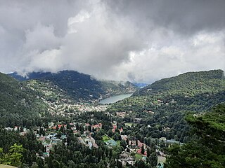
Nainital is a town and headquarters of Nainital district of Kumaon division, Uttarakhand, India. It is the judicial capital of Uttarakhand, the High Court of the state being located there and is the headquarters of an eponymous district. It also houses the Governor of Uttarakhand, who resides in the Raj Bhavan. Nainital was the summer capital of the United Provinces.
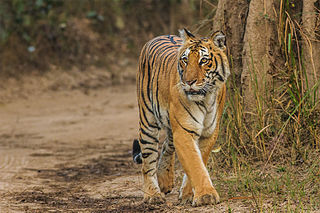
Jim Corbett National Park is a national park in India located in the Nainital district of Uttarakhand state. The first national park in India, it was established in 1936 during the British Raj and named Hailey National Park after William Malcolm Hailey, a governor of the United Provinces in which it was then located. In 1956, nearly a decade after India's independence, it was renamed Corbett National Park after the hunter and naturalist Jim Corbett, who had played a leading role in its establishment and had died the year before. The park was the first to come under the Project Tiger initiative.

Uttarakhand, formerly known as Uttaranchal, is a state in northern India. The state is divided into two divisions, Garhwal and Kumaon, with a total of 13 districts. The winter capital and largest city of the state is Dehradun, which is also a railhead. On 5 March 2020, Bhararisain, a town in the Gairsain Tehsil of the Chamoli district, was declared as the summer capital of Uttarakhand. The High Court of the state is located in Nainital, but is to be moved to Haldwani in future.

Almora is a district in the Kumaon Division of Uttarakhand state, India. The headquarters is at Almora. It is 1,638 meters above sea level. The neighbouring regions are Pithoragarh district to the east, Chamoli district to the west, Bageshwar district to the north and Nainital district to the south.

Udham Singh Nagar District is a district of Uttarakhand state in northern India. Rudrapur is the district headquarters. This district consists of nine Tehsils named Bajpur, Gadarpur, Rudrapur, Jaspur, Kashipur, Kichha, Khatima, Sitarganj, Nanakmatta. The district is located in the Terai region, and is part of Kumaon Division. It is bounded on the north by Nainital District, on the northeast by Champawat District, on the east by Nepal, and on the south and west by Bareilly, Rampur, Moradabad, Pilibhit and Bijnor District of Uttar Pradesh state. The district was created on 29 September 1995, by Mayawati government out of Nainital District. It is named for freedom fighter and Indian revolutionary Udham Singh.

Ranikhet is a hill station and cantonment town, near Almora Town in Almora district in the Indian state of Uttarakhand. It is the home of the Military Hospital, Kumaon Regiment (KRC) and Naga Regiment and is maintained by the Indian Army.

Mukteshwar is a village and tourist destination in the Nainital district of Uttarakhand, India. It sits high in the Kumaon Hills at an altitude of 2171 meters (7500 feet), 51 km from Nainital, 72 km from Haldwani, and 343 km from Delhi.

Pantnagar is a town and a university campus in Udham Singh Nagar District, Uttarakhand. Nainital, Kashipur, Rudrapur, Kiccha and Haldwani are the major cities surrounding Pantnagar.
Kashipur is a city of Udham Singh Nagar district in the Indian state of Uttarakhand, and one of its seven subdivisions. Located in the western part of Udham Singh Nagar district, it is Kumaun's third most populous city and the sixth most populous in Uttarakhand. According to the 2011 Census of India, the population is 121,623 for the city of Kashipur and 283,136 for Kashipur Tehsil. Kashipur also has IIM Kashipur, one of the thirteen Indian Institutes of Managements the government has set up during the Eleventh Five-year Plan.

Gadarpur is a post independence city and a municipal board in Udham Singh Nagar district in the state of Uttarakhand, India. This city was formed with the arrival of the refugees from Pakistan at the time of partition of 1947. The refugees settled here and started living here. The refugees are Punjabi which makes up a majority in the city.
Rudrapur is a city that serves as the headquarters of the Udham Singh Nagar district in the Indian state of Uttarakhand. Located at a distance of about 250 km (160 mi) northeast of New Delhi and 250 km (160 mi) south of Dehradun, Rudrapur is located in the fertile Terai plains in the southern part of Kumaon division over an area of 27.65 km2. With a population of 140,857 according to the 2011 census of India, it is the 5th most populous city of Uttarakhand.
Thakurdwara is a town in Moradabad district in the indian state of Uttar Pradesh.

Kausani is a hill station and Village situated in Bageshwar district in the state of Uttarakhand, India. It is famous for its scenic splendour and its spectacular 300 km-wide panoramic view of Himalayan peaks like Trisul, Nanda Devi and Panchchuli. Mahatma Gandhi called this place the 'Switzerland of India', due to similarity in landscapes.
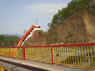
Garjiya Devi Temple is a hindu Devi temple located in the Garjiya village near Ramnagar, Uttarakhand, India, on the outskirts of the Corbett National Park. It is a sacred Shakti shrine where Garjiya Devi is the presiding deity. The temple is situated over a large rock in the Kosi river and is one of the most famous temples of the Nainital district, visited by thousands of devotees during Kartik Poornima, a Hindu holy day celebrated on the fifteenth lunar day of Kartik.

Pantnagar Airport is a domestic airport serving Pantnagar and its adjoining regions, located in the Udham Singh Nagar district in of Uttarakhand, India. It is operated by the Airports Authority of India. It is the nearest airport to the Kumaon division and is located in the middle of Haldwani and Rudrapur, the two largest cities of Kumaon. It is 26 km from Haldwani and from the Kumaon hill stations of Nainital (65 km), Bhimtal (50 km), Ranikhet (110 km) and Almora (120 km), Bareilly (65 km) and the Jim Corbett National Park (120 km).

Shree Moteshwar Mahadev, also known as Shree Bheem Shankar Mahadev, is an abode of Lord Shiva in Kashipur of Uttarakhand state, India. This place was known as the Dakini State in ancient days.
Betalghat is a small town and tehsil in Nainital district, Uttarakhand, India. As of 2011, it had a total population of 21265 spread over 4357 households.
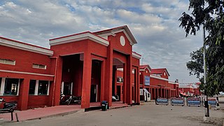
Haldwani railway station is a main railway station located in Haldwani in Nainital district of Uttarakhand State of India.
Ramnagar railway station is a small railway station in Nainital district, Uttarakhand. Its code is RMR. It serves Ramnagar city. The station consists of four platforms. The nearest airport is Pantnagar Airport at the distance of 55 km.
Aampokhra, or Aam Pokhra, is a village in Uttarakhand, northern India. It is located in Ramnagar tehsil of Nainital district, approximately 81 kilometers from Nainital, the headquarters of the district.


