Himalayan subtropical pine forests

Last updated
Himalayan subtropical pine forests
Pinus roxburghii Ranikhet.jpg
Ecoregion IM0301.png
Ecoregion territory (in purple)
Ecology
Realm Indomalayan
Biome Tropical and subtropical coniferous forests
Borders
Bird species469 [1]
Mammal species162 [1]
Geography
Area76,200 km2 (29,400 sq mi)
Countries
Conservation
Habitat loss86.65% [1]
Protected4.09% [1]

The Himalayan subtropical pine forests are a large subtropical coniferous forest ecoregion covering portions of Bhutan, India, Nepal, and Pakistan.

Contents

Geography

This huge pine forest stretches for 3000 km across the lower elevations of the great Himalaya range for almost its entire length including parts of Pakistan's Punjab Province in the west through Azad Kashmir, the northern Indian states of Jammu and Kashmir, Himachal Pradesh, Uttarakhand and Sikkim, Nepal and Bhutan, which is the eastern extent of the pine forest. Like so many Himalayan ecosystems the pine forests are split by the deep Kali Gandaki Gorge in Nepal, to the west of which the forest is slightly drier while it is wetter and thicker to the east where the monsoon rains coming off the Bay of Bengal bring more moisture. [2]

Flora

The predominant flora of the ecoregion is a thin woodland of drought-resistant Pinus roxburghii trees with a ground cover of thick grass, as regular fires do not allow a shrubby undergrowth to establish itself. The ground cover consists of Arundinella setosa, cogon grass ( Imperata cylindrica ) and Themeda anathera.

Pine forest mainly grows on south-facing slopes although in western Nepal there are areas facing in other directions. Some of the larger areas can be found in the lower elevations of Kangra and Una Districts of Himachal Pradesh and in Bhutan. It occurs in smaller patches in eastern Himachal Pradesh and lower Uttarakhand, in the more thinly populated western Nepal, and on the lower elevations (between 1,000 and 2,000m) of the Sivalik and Himachal ranges.

Fauna

Although there is not a rich variety of wildlife here when compared to tropical rainforest for example the region is important habitat, especially for birds. Wildlife includes tigers and leopards although in smaller numbers than in the lowland areas where herds of grazing antelopes provide food for them, whereas these slopes do not sustain grazing in large numbers. More typical animals of the pine forest are langurs and other animals of the Himalayas. Birds include the chestnut-breasted partridge and cheer pheasants that hide in the lush grass.

Conservation

These habitats are vulnerable to logging for firewood or conversion to grazing or farmland and more than half the area has been cleared or degraded which then allows the mountain water to wash away the soil quickly. The most profound changes can be seen in central and eastern Nepal, where the forest has been cleared for terrace farming. The protected areas of pine forest are small but include part of the larger Jim Corbett National Park.

See also

Related Research Articles

<span class="mw-page-title-main">Singalila National Park</span> National park of India on the Singalila Ridge in Darjeeling district, West Bengal

Singalila National Park is a National park of India located on the Singalila Ridge at an elevation of more than 2300 metres above sea level, in the Darjeeling district of West Bengal. It is well known for the trekking route to Sandakphu that runs through it.

<span class="mw-page-title-main">Terai–Duar savanna and grasslands</span>

The Terai–Duar savanna and grasslands is a narrow lowland ecoregion at the base of the Himalayas, about 25 km (16 mi) wide, and a continuation of the Indo-Gangetic Plain in India, Nepal and Bhutan. It is colloquially called Terai in the Ganges Basin east to Nepal, then Dooars in West Bengal, Bhutan and Assam east to the Brahmaputra River. It harbours the world's tallest grasslands, which are the most threatened and rare worldwide.

<span class="mw-page-title-main">Upper Gangetic Plains moist deciduous forests</span> Ecoregion in northern India

The Upper Gangetic Plains moist deciduous forests is a tropical and subtropical moist broadleaf forests ecoregion of northern India.

<span class="mw-page-title-main">Brahmaputra Valley semi-evergreen forests</span> Ecoregion of India and Bhutan

The Brahmaputra Valley semi-evergreen forests is a tropical moist broadleaf forest ecoregion of Northeastern India, southern Bhutan and adjacent Bangladesh.

<span class="mw-page-title-main">Geography of Himachal Pradesh</span>

The state of Himachal Pradesh is spread over an area 55,673 km2 (21,495 sq mi) and is bordered by Jammu and Kashmir and Ladakh on the north, Punjab on the southwest, Haryana on the south, Uttarakhand on the southeast, a small border with Uttar Pradesh in the south, and Tibet on the east. Entire Himachal Pradesh lies in the mountainous Himalaya region, rich in natural resources

<span class="mw-page-title-main">Himalayan subtropical broadleaf forests</span>

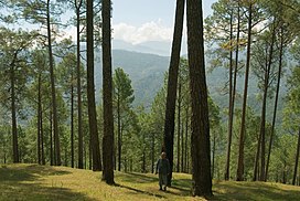
The Himalayan subtropical broadleaf forests is an ecoregion that extends from the middle hills of central Nepal through Darjeeling into Bhutan and also into the Indian States of Uttar Pradesh and Bihar. It represents the east–west-directed band of subtropical broadleaf forest at an altitude of between 500 and 1,000 m along the Outer Himalayan Range, and includes several forest types traversing an east to west moisture gradient.

<span class="mw-page-title-main">Eastern Himalayan broadleaf forests</span>

The Eastern Himalayan broadleaf forests is a temperate broadleaf forest ecoregion found in the middle elevations of the eastern Himalayas, including parts of Nepal, India, Bhutan and Myanmar. These forests have an outstanding richness of wildlife.

<span class="mw-page-title-main">Eastern Himalayas</span> Eastern half of the Himalayas mountain range

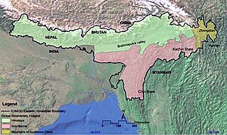
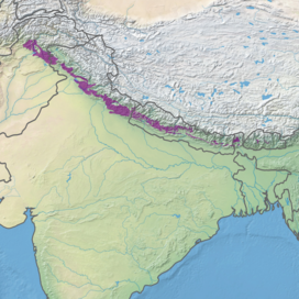
The Eastern Himalayas extend from eastern Nepal across Northeast India, Bhutan, the Tibet Autonomous Region to Yunnan in China and northern Myanmar. The climate of this region is influenced by the monsoon of South Asia from June to September. It is a biodiversity hotspot, with notable biocultural diversity.

<span class="mw-page-title-main">Western Himalayan alpine shrub and meadows</span>

The Western Himalayan alpine shrub and meadows is a montane grasslands and shrublands ecoregion of Nepal, India, and Tibet, which lies between the tree line and snow line in the western portion of the Himalaya Range.

<span class="mw-page-title-main">Eastern Himalayan alpine shrub and meadows</span> Ecoregion in the Eastern Himalayas

The Eastern Himalayan alpine shrub and meadows is a montane grasslands and shrublands ecoregion of Bhutan, China, India, Myanmar, and Nepal, which lies between the tree line and snow line in the eastern portion of the Himalaya Range.

<span class="mw-page-title-main">Northern Triangle temperate forests</span>

The Northern Triangle temperate forests is a temperate broadleaf and mixed forest ecoregion of thick forest covering the mountains of northern Myanmar.

<span class="mw-page-title-main">Western Himalayan broadleaf forests</span>

The Western Himalayan broadleaf forests is a temperate broadleaf and mixed forest ecoregion which is found in the middle elevations of the western Himalayas, including parts of Nepal, India, and Pakistan.

<span class="mw-page-title-main">Eastern Himalayan subalpine conifer forests</span>

The 'Eastern Himalayan subalpine conifer forests is a temperate coniferous forests ecoregion which is found in the middle and upper elevations of the eastern Middle Himalayas, in western Nepal, Bhutan, northern Indian states including Arunachal Pradesh and Sikkim and adjacent Myanmar.

<span class="mw-page-title-main">Northeastern Himalayan subalpine conifer forests</span> Ecoregion in Northeast Himalayas

The Northeastern Himalayan subalpine conifer forests are a temperate coniferous forests ecoregion of the middle to upper elevations of the eastern Himalayas and southeast Tibetan Plateau. The ecoregion occurs in southeastern Tibet Autonomous Region, China, in northern and eastern Arunachal Pradesh, India, and extreme eastern Bhutan.

<span class="mw-page-title-main">Northwestern Himalayan alpine shrub and meadows</span> Ecoregion in the Northwestern Himalayas

The Northwestern Himalayan alpine shrub and meadows is a montane grasslands and shrublands ecoregion of the elevations of the northwestern Himalaya of China, India, and Pakistan.

<span class="mw-page-title-main">Western Himalayan subalpine conifer forests</span>

The Western Himalayan subalpine conifer forests is a temperate coniferous forests ecoregion of the middle and upper elevations of the western Middle Himalayas of Nepal, India, and Pakistan.

<span class="mw-page-title-main">Southeastern mixed forests</span> Temperate broadleaf and mixed forests ecoregion of the United States

The Southeastern mixed forests are an ecoregion of the temperate broadleaf and mixed forest biome, in the lower portion of the Eastern United States.

The ecology of the Himalayas varies with climate, rainfall, altitude, and soils. The climate ranges from tropical at the base of the mountains to permanent ice and snow at the highest elevations. The amount of yearly rainfall increases from west to east along the southern front of the range. This diversity of climate, altitude, rainfall and soil conditions supports a variety of distinct plant and animal species, such as the Nepal gray langur

References

  1. 1 2 3 4 Hoekstra, J. M.; Molnar, J. L.; Jennings, M.; Revenga, C.; Spalding, M. D.; Boucher, T. M.; Robertson, J. C.; Heibel, T. J.; Ellison, K. (2010). Molnar, J. L. (ed.). The Atlas of Global Conservation: Changes, Challenges, and Opportunities to Make a Difference . University of California Press. ISBN   978-0-520-26256-0.
  2. "Himalayan subtropical pine forests". Terrestrial Ecoregions. World Wildlife Fund.